A Complete 180
Spring weather often sets the tone for the
summer to come. Last year flowers were blooming in March, an omen of
record summer heat and deepening drought. This spring's chill and freak
April snows may be a premonition of a radically different summer for
Minnesota, one characterized by cooler, wetter weather, with frequent
severe outbreaks & occasional heat spikes, but nothing like 2012.
A Year Without a Summer? Probably nothing that
dire, but something tells me you'll be checking Doppler online, and on
your smartphone, more often than you'd like. The upside? Water in our
lakes, and if hail holds off a potential bumper crop for corn, wheat and
beets.
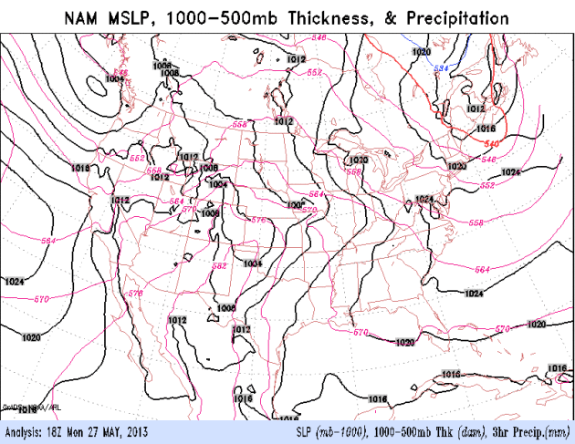
Why the shift? The jet stream, the main
superhighway for storms, is howling an average of 400-600 miles farther
south than last year at this time. The frontal boundary separating
chilly from blast-furnace heat may stall out near Minnesota into much of
June, possibly longer, increasing the risk of frequent storms.
The most intense T-storms will rumble south of
MSP today; the best chance of T-storms Thursday - then drying out &
cooling off by late week. No hot fronts in sight, just a soggy taste of
late April.
Mosquitoes are doing high-fives right about now.
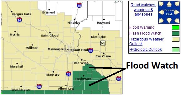
Flash Flood Watch. Monday's heavy rains over
southeastern Minnesota have left the soil saturated; any additional
heavy rain will quickly run off into streets and streams. Details from
the NWS:
A FLASH FLOOD WATCH MEANS THAT CONDITIONS MAY DEVELOP THAT LEAD
TO FLASH FLOODING. FLASH FLOODING IS A VERY DANGEROUS SITUATION.

DO NOT DRIVE YOUR VEHICLE INTO AREAS WHERE THE WATER COVERS THE
ROADWAY. THE WATER DEPTH MAY BE TOO GREAT TO ALLOW YOUR CAR TO
CROSS SAFELY. VEHICLES IN RISING WATER SHOULD BE ABANDONED
QUICKLY. IF YOUR VEHICLE STALLS...ABANDON IT AND SEEK HIGHER
GROUND IMMEDIATELY. RAPIDLY RISING WATER MAY ENGULF YOUR VEHICLE
AND ITS OCCUPANTS AND SWEEP THEM AWAY. MOVE TO HIGHER GROUND.

YOU SHOULD MONITOR LATER FORECASTS AND BE PREPARED TO TAKE ACTION
SHOULD FLASH FLOOD WARNINGS BE ISSUED.
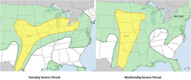
Nagging Severe Potential. Today's risk extends from
the Black Hills and Nebraska to Chicago, Detroit and Pittsburgh.
Wednesday the risk spreads north with a surge of warm, moist air,
reaching the Twin Cities and Eau Claire. Maps: NOAA SPC.
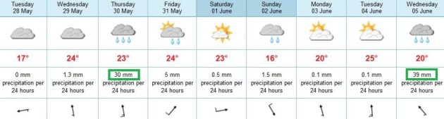
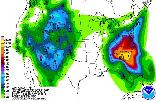
A Wet, Stormy Pattern. We seem to be stuck in a
cooler than average, wet, stormy rut, with no end in sight (looking out 2
weeks). ECMWF guidance shows the heaviest rain on Thursday, drying out a
little late Friday and Saturday - just light instability showers
Sunday. The next surge of warm, humid air may spark more heavy/severe
storms by the middle of next week.
No Need To Water Anytime Soon. The models have been
especially unreliable with this on-again, off-again warm frontal
passage. Warm fronts appear to tire before reaching our latitude, but if
you believe the models the best chance of heavy T-storms will come
Wednesday PM into Thursday.
A Tardy Warm Front. Warm air is pushing north much
slower than models were predicting a few days ago. I suspect today will
be mostly-dry; heaviest showers and T-storms pushing across Iowa toward
Chicago. The NAM model suggests that warm air will (finally) reach us
Wednesday, increasing the potential for strong to severe T-storms.
Serious puddle potential lingers into Thursday, then we dry out during
the day Friday.
Urban And River Flooding Risk. A nearly stationary
frontal boundary much of this week will result in repeated swarms of
strong to severe thunderstorms. A few of these storms will produce
large hail and damaging winds, but the most pervasive and widespread
risk across the Midwest will be flooding: both urban and river/stream.
Models print out as much as 4-6" of rain from Wichita and Kansas City
to Des Moines, the Quad Cities, Rockford, Chicago, Madison and
Milwaukee. Areas that normally enounter problems with sporadic flooding
will want to remain on alert this week.
Confidence level: moderate to high.
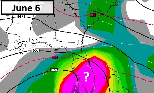
Potential Florida Soaker. Long-range models have
been fairly consistent spinning up a tropical wave or weak tropical
storm by the middle of next week. Although a full-fledged hurricane
seems unlikely, even tropical depressions are capable of copious rains
capable of significant flooding. Such may be the case the latter half
of next week across much of Florida. Models strengthen this system into
a possible tropical storm or hurricane well offshore, pulling it into
the Canadian Maritimes within 2 weeks. We'll see, but the fact that we
may be seeing tropical activity so early in the season confirms my
suspicions of a busy hurricane season for the Atlantic basin.
Confidence level: low.
Putting This Spring's Cold In Context. January thru
March was the 8th warmest period in over 100 years for the planet, but
it's human nature to look out the window and make assumptions. I get
it.
UCAR has a good overview of our chilly spring, placed in a larger context of a slowly warming atmosphere; here's an excerpt: "
What
led to this springtime string of cold and snow? It’s due in part to
the perfectly normal seasonal shift of the polar jet stream. The jet
often flows from west to east across the heart of the United States in
winter. By summer, it’s flowing mainly across Canada and the
northern tier of states. Spring and autumn are times of transition,
when the jet oscillates back and forth. Throughout the year, packets
of upper-level low pressure ride the jet stream, rippling along the
flow like waves and often bringing stormy weather with them.
Sometimes these atmospheric waves “break.” Southward dips in the jet
stream can become so large and deep that they snap off from the main
flow. The result: an upper low marooned hundreds of miles south of the
polar jet stream..."
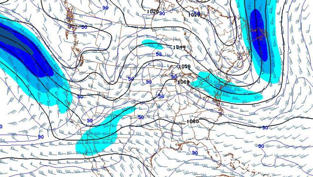
Image credit above: "
Cut-off centers
of low pressure loitered near California and the U.S. South early
this week, with the polar jet stream in a summerlike position across
northern Canada. Shown here are upper-level winds as of 8:00 a.m. EDT
on May 6." (Image courtesy
NOAA/NCEP Model Analysis & Guidance.)
After The Storm: Safe Rooms Need To Be Mandated In Perilous Places. Here's a portion of an Op-Ed at
The Pittsburgh Post-Gazette: "...
It
rankles that Oklahoma's U.S. senators, James Inhofe and Tom Coburn,
have voted against federal funding for other disaster relief, including
for victims of Hurricane Sandy. Yes, they had their reasons --
concerns for wasteful federal spending and deficits -- but a day of
reckoning comes for ingrate behavior. In Moore, it came in a terrifying
funnel cloud. Political ideology should have been blown away in this
storm. State and local governments in areas at risk should insist on
safe rooms, at least in all new construction. The cost might be high,
but so is the cost of repetitive tragedy. It is said that God helps
those who help themselves; federal aid ought to be predicated on it."
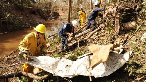
Sophisticated Tornado Warning System Saved A Lot Of Lives In Oklahoma. Here's a segment from
Business Insider: "
When a devastating tornado touched down in Moore, Oklahoma on May 20, locals had 16 minutes to get to safety before the mile-wide EF4 hit. Even that seemingly short warning system is enough to save a ton of lives. The Oklahoma City siren system, a network of 181 emergency warning sirens,
was state-of-the-art when it went online in April, 2002. It cost
$4.5 million to install the new system, which replaced the cold
war-era sirens that covered only the most densely populated parts of
the city..."
Photo credit: SUE OGROCKI / AP
Storm Shelters And Safe Rooms Save Lives When Tornadoes, Hurricanes Strike. Here's a portion of a timely article at
EHS Today: "...
High
wind speeds produce flying debris turning construction materials,
furniture, appliances and just about anything into deadly missiles. The
standard requires that walls, windows and doors are tested to
withstand flying projectiles.
Tornado storm shelters are required to
house people for 2 hours and include minimum requirements for
ventilation, sanitation facilities, a fire extinguisher, lighting and
other minimal power needs.
A storm shelter does not need to be a
separate space or structure. A shelter can be a “hardened” room inside a
building that normally is used for other purposes. For instance,
schools often use a classroom or group of classrooms, a gymnasium or
library as a shelter. The walls, doors, ceilings and windows are then
designed to withstand the higher wind loads and flying debris.
.."
Photo credit above: "
In Moore, Okla., there have been
dramatic examples of survivors who lived through the killer tornado
because the home or other building they were in had a safe room or
fortified basement." Jocelyn Augustino/FEMA
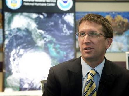
Hurricane Center Chief Focusing On Water Hazards. The power of moving water is overwhelming, as Sandy proved last year. Here's an excerpt from a story at
Ocala.com: "...
It
wasn’t just high winds that posed a threat and caused damage, said
National Hurricane Center Director Rick Knabb, who joined Florida’s
emergency managers earlier this month in Fort Lauderdale at the annual
Governor’s Hurricane Conference. “2012 was all about water, water,
water. Debby, Isaac, Sandy,” Knabb said. “It was storm surge from the
ocean, it was inland flooding, it was river flooding.” The hurricane
center has been working for several years to improve its storm surge
forecasts and public warnings about potential flooding risks far from
the coastline. The last season has added a sense of urgency to get
those upgrades ready by the 2015 season, Knabb said..."
Photo credit above: "
National Hurricane Center Director
Rick Knabb talks this month in Fort Lauderdale about the lessons
learned from Hurricane Sandy and expectations for the Atlantic storm
season that begins Saturday. Knabb and hurricane center forecasters
joined emergency managers at the annual Governor’s Hurricane Conference." (The Associated Press)
Weather Service To Add Major Might To Computing Power. With any luck I won't to rely on the European ECMWF model quite so much in the years ahead.
Kitsap Sun has the story - here's an excerpt: "...
After coming under fire for falling behind the capabilities of other nations,
the National Weather Service (NWS) is setting out to make an
unprecedented increase in its computing power over the next several
years, the agency announced this week. The computing boost will triple a
key measure of the agency's main weather model, and could yield
major improvements to its weather forecasting and warnings
capabilities. The program is made possible by recent funding from
Congress contained in the Hurricane Sandy
relief legislation, which was signed into law in January. The NWS
plans to use $25 million of the $48 million provided to it in the Sandy
supplemental bill, along with funds that are called for in President
Obama’s fiscal year 2014 budget proposal,
to bring about “unprecedented” computing upgrades — going from an
operational computing capacity of 213 peak teraflops at the end of the
current fiscal year, to 1,950 peak teraflops by the end of fiscal
year 2015, according to NWS Director Louis Uccellini..."
Climate Stories...
Climate Change: Human Disaster Looms, Says Research. Cheap, alarmist hype? I sure hope so. Here's an excerpt from
Climate Central: "...
Alexander
Otto, at the University of Oxford, lead author of the research, told
the Guardian that there was much that climate scientists could still not
fully factor into their models. He said most of the recent warming had
been absorbed by the oceans but this would change as the seas heat up.
The thermal expansion of the oceans is one of the main factors behind
current and projected sea level rises. The highest global average
temperature ever recorded was in 1998, under the effects of a strong El
Niño, a southern Pacific weather system associated with warmer and
stormy weather, which oscillates with a milder system called La Niña.
Since then the trend of average global surface temperatures has shown a
clear rise above the long-term averages – the 10 warmest years on
record have been since 1998 – but climate skeptics have claimed that
this represents a pause in warming..."
Photo credit: "
The trend of average global surface
temperatures has shown a clear rise above the long-term averages - the
10 warmest years on record have been since 1998." Credit: flickr/Global Jet.
Geoengineering: Our Last Hope, Or A False Promise? Tinkering with the atmosphere on a global scale - what can possibly go wrong? Here's a clip from an important
New York Times article on tinkering with the atmosphere, attempting to undo the impact of carbon pollution: "...
Geoengineering — the deliberate, large-scale intervention in the climate system to counter global warming
or offset some of its effects — may enable humanity to mobilize its
technological power to seize control of the planet’s climate system,
and regulate it in perpetuity. But is it wise to try to play God with
the climate? For all its allure, a geoengineered Plan B may lead us
into an impossible morass. While some proposals, like launching a cloud
of mirrors into space to deflect some of the sun’s heat, sound like
science fiction, the more serious schemes require no insurmountable
technical feats. Two or three leading ones rely on technology that is
readily available and could be quickly deployed..."
Century-Old Science Helps Confirm Global Warming. Here's an excerpt from
NASA's Jet Propulsion Laboratory: "
A
new NASA and university analysis of ocean data collected more than
135 years ago by the crew of the HMS Challenger oceanographic
expedition provides further confirmation that human activities have
warmed our planet over the past century. Researchers from the
University of Tasmania, Sandy Bay, Australia; and NASA's Jet
Propulsion Laboratory, Pasadena, Calif., combined the ship's
measurements of ocean temperatures with modern observations from the
international Argo array of ocean profiling floats. They used both as
inputs to state-of-the-art climate models, to get a picture of how
the world's oceans have changed since the Challenger's voyage..."
Image credit above: "
Drawing
of the HMS Challenger survey vessel preparing to measure ocean
temperatures by lowering thermometers deep into the ocean on ropes in
1872. A new NASA and University of Tasmania study combined the ship's
135-plus-year-old measurements of ocean temperatures with modern
observations to get a picture of how the world's ocean has changed
since the Challenger's voyage. The research reveals that warming of
Earth can be clearly detected since 1873, with the ocean absorbing the
majority of the heat." Image credit: NOAA.