Memorial Day Jackets
With a son in the Navy I now read the news with
new eyes. Brett's service gives me new appreciation for the men &
women who gave everything for this country. No, freedom isn't free.
Thank a veteran for their service today.
And yes, the weather could be better. At least
it didn't snow. Climate records show 2 Memorial Days since the mid-1800s
cold enough for flurries. Boating in heavy jackets; a friend reported
tiny icebergs on Gull lake as recently as last week.
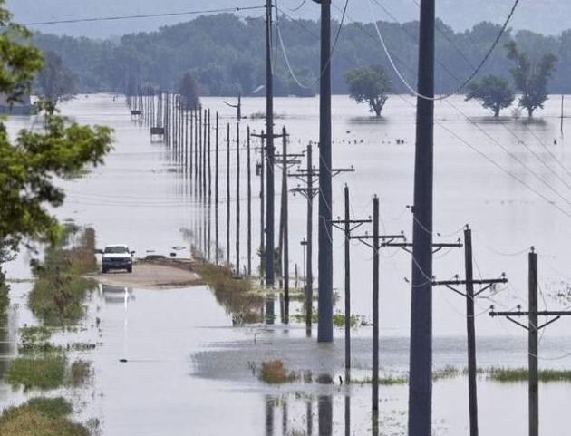
Warm frontal thunderstorms sparked flooding over
Iowa over the weekend; a few strong T-storms arrive by evening;
downpours most likely tonight & Tuesday. Today won't win any awards
with highs in the 60s to near 70. The sun may even pop out for 15
minutes.
No, I don't quite yet grasp the mutual attraction of holidays & puddles,either.
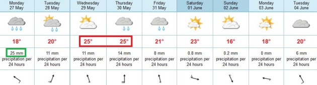
A stormy week is on tap as a slow-moving front
sloshes across the Upper Midwest. Models show drier, cooler weather
returning by next weekend.
The cool bias that kicked in back in February is
still with us. I see a cooler, stormier June, with a few severe storm
outbreaks.
At least our storms don't have names. GFS guidance hints at a possible tropical storm brushing Florida by June 6. Details below.
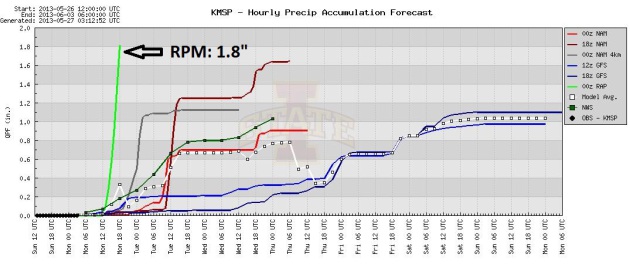
Memorial Day Soakers? The RAP (Rapid Scan) model
brings heavy showers and T-storms into the metro area by early morning
today, printing out nearly 2" of rain. Skies may brighten by afternoon,
but with the warm front almost directly overhead it'll be a close call
whether we can see any clearing. Other models print out over 1" of rain,
pulling in another band of heavy showers and thunderstorms by late
afternoon and evening. Yep, looks like a major holiday - possibly an
omen of a soggy (cooler) summer to come.
Ripe. The RAP model has a pretty good track record
lately, so I'm not discounting the band of warm frontat T-storms
forecast to drift into the metro area this morning. Confidence level:
low to moderate. Timing with warm frontal storms is always tricky, but
they usually flare up early morning and evening/overnight hours.
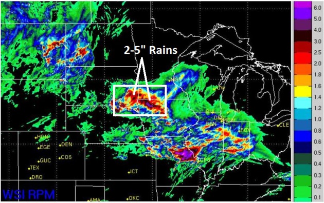
Flood Potential. WSI's high resolution 4 km.
RPM model prints out some 2-5" rains over the next 20 hours from near
SIoux Falls into far southwestern Minnesota and northwest Iowa.
A Stormy Week. ECMWF model data suggests today will
be the wettest day of a fairly soggy week (of course); temperatures
warming into the low 80s Wednesday and Thursday with a few strong/severe
T-storms possible. We dry out and cool off slightly by the weekend.
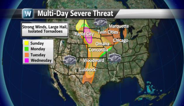 Severe Potential
.
A surge of Gulf moisture interacting with strong jet stream winds and
an eastbound cool front will spark strong to severe storms from Montana
across the Plains, Midwest, reaching the Great Lakes by Tuesday. For
Minnesota the best potential for hail and high winds may come Tuesday.
Graphic: WeatherNation TV.
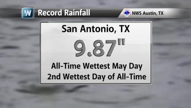 Serious Flash Flooding in San Antonio
. Nearly 10" of rain drenched San Antonio, Texas Saturday, the wettest May day on record - second wettest ever recorded. That's roughly 2-3 months of rain falling on the metro area in less than 24 hours.
Putting This Spring's Cold In Context. January thru
March was the 8th warmest period in over 100 years for the planet, but
it's human nature to look out the window and make assumptions. I get
it.
UCAR has a good overview of our chilly spring, placed in a larger context of a slowly warming atmosphere; here's an excerpt: "
What
led to this springtime string of cold and snow? It’s due in part to
the perfectly normal seasonal shift of the polar jet stream. The jet
often flows from west to east across the heart of the United States in
winter. By summer, it’s flowing mainly across Canada and the northern
tier of states. Spring and autumn are times of transition, when the
jet oscillates back and forth. Throughout the year, packets of
upper-level low pressure ride the jet stream, rippling along the flow
like waves and often bringing stormy weather with them. Sometimes
these atmospheric waves “break.” Southward dips in the jet stream can
become so large and deep that they snap off from the main flow. The
result: an upper low marooned hundreds of miles south of the polar jet
stream..."
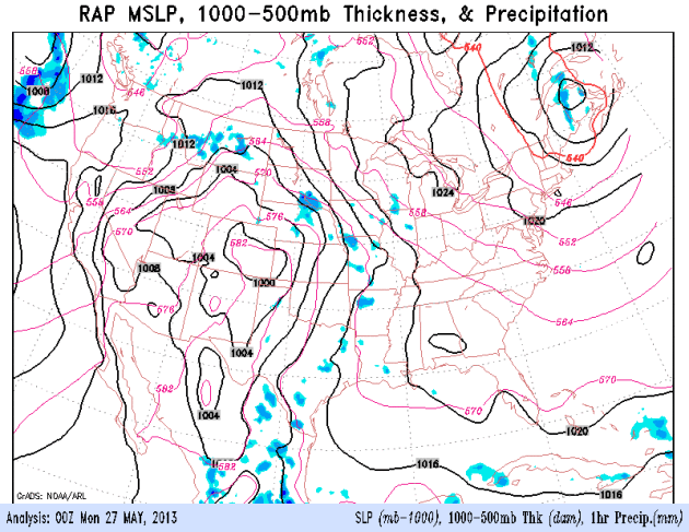
Image credit above: "
Cut-off centers
of low pressure loitered near California and the U.S. South early this
week, with the polar jet stream in a summerlike position across
northern Canada. Shown here are upper-level winds as of 8:00 a.m. EDT
on May 6." (Image courtesy
NOAA/NCEP Model Analysis & Guidance.)
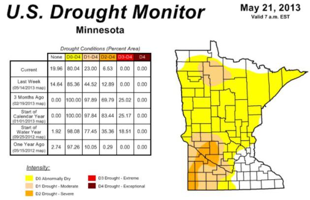
Drought Continues To Ease. The entire Twin Cities
and St. Cloud metro areas are officially out of the drought now,
lingering pockets of moderate to severe drought over southwestern
Minnesota, but conditions continue to improve statewide. Yes, this
spring has been a bust, but at least there's water in our lakes, and
look at how good your lawn looks! Details from the
Minnesota Climatology Working Group: "
The U. S. Drought Monitor, released on May 23 places portions of southwest Minnesota in the Severe Drought category (map at right).
Only 7 percent of Minnesota's landscape is in Severe Drought, a
substantial improvement over early April when 67 percent of Minnesota
was experiencing Extreme Drought or Severe Drought. The maximum
geographic extent of the present drought was late autumn 2012 through
mid-winter when 83 percent of the state was rated in the Extreme
Drought or Severe Drought categories..."
Sophisticated Tornado Warning System Saved A Lot Of Lives In Oklahoma. Here's a segment from
Business Insider: "
When a devastating tornado touched down in Moore, Oklahoma on May 20, locals had 16 minutes to get to safety before the mile-wide EF4 hit. Even that seemingly short warning system is enough to save a ton of lives. The Oklahoma City siren system, a network of 181 emergency warning sirens,
was state-of-the-art when it went online in April, 2002. It cost $4.5
million to install the new system, which replaced the cold war-era
sirens that covered only the most densely populated parts of the city..."
Photo credit: SUE OGROCKI / AP
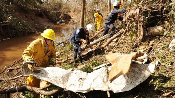
Storm Shelters And Safe Rooms Save Lives When Tornadoes, Hurricanes Strike. Here's a portion of a timely article at
EHS Today: "...
High
wind speeds produce flying debris turning construction materials,
furniture, appliances and just about anything into deadly missiles. The
standard requires that walls, windows and doors are tested to
withstand flying projectiles.
Tornado storm shelters are required to
house people for 2 hours and include minimum requirements for
ventilation, sanitation facilities, a fire extinguisher, lighting and
other minimal power needs.
A storm shelter does not need to be a
separate space or structure. A shelter can be a “hardened” room inside a
building that normally is used for other purposes. For instance,
schools often use a classroom or group of classrooms, a gymnasium or
library as a shelter. The walls, doors, ceilings and windows are then
designed to withstand the higher wind loads and flying debris.
.."
Photo credit above: "
In Moore, Okla., there have been
dramatic examples of survivors who lived through the killer tornado
because the home or other building they were in had a safe room or
fortified basement." Jocelyn Augustino/FEMA
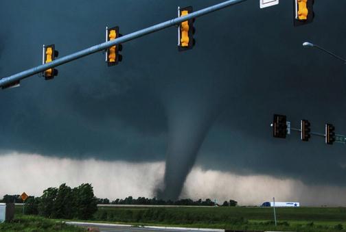
Racing The Clock And A Storm: A Way Of Life In Tornado Alley. Here's a clip from a
New York Times article
on how Oklahomans deal with tornado season, an amazing,
minute-by-minute account of the minutes leading up to Moore's EF-5: "...
In this breeding ground of Oklahoma tornadoes,
people prepare for the season with the care that the defensive
coordinator for their Sooners prepares for the inevitable autumn. They
develop family plans, hang on the words of meteorologists, and, in
places like Moore, become accustomed to the Saturday noontime testing
of emergency sirens. At the same time there exists disbelief that
the devastation visited upon neighbors could ever happen to them or,
that is, could ever happen to them again. Amid all the siren tests
and awareness and false alarms, the warning can still be a
half-hour, maybe a little more, maybe a little less. This means you
must stop what you are doing, shake off the disbelief, track down
loved ones and find shelter, all in the time it takes to watch a few
rounds of “Jeopardy!"...
Photo credit above: "
A handout photo of a tornado in
Newcastle, Okla., before it reached Moore, about 10 miles away, on May
20, 2013. With authorities saying they have likely recovered all the
bodies to be found beneath the rubble left by the Category 5
tornado, the focus turned to the long and expensive path of
recovering from one of the most catastrophic storms in Oklahoma's
history." (Nick Rutledge via The New York Times).
5 Myths About Tornadoes. Meteorologist Mike Smith makes some very good points in this story at
The Washington Post; here's an excerpt that caught my attention: "...
But
many misconceptions persist — misconceptions that can encourage bad
policy and put lives at risk. I’d like to dispel some of the myths.
1. Meteorologists aren’t any good at forecasting these storms.
How does 99.3 percent sound? In 2011, 553 people lost their
lives in tornadoes. For all but four of those victims (99.3 percent),
both a tornado watch and a tornado warning were in effect before the
storm arrived. Modern tornado warnings are Nobel Prize-worthy endeavors
that combine weather science, social science and technology. As
recently as 1990, people in the path of a tornado were lucky to get
five minutes’ warning. Now, thanks to advances in radar, computer
simulations and research on how tornadoes develop, the average “lead
time” is 12 minutes — and more than 15 minutes for major tornadoes. The
city of Moore had a stunning 36 minutes of warning..."
Tornadoes Were Just The Beginning. This Hurricane Season Is Going To Be Stormy. Here's an excerpt from
Time Magazine: "...
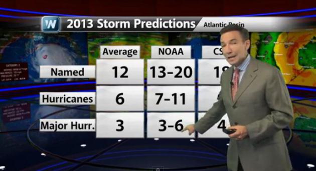
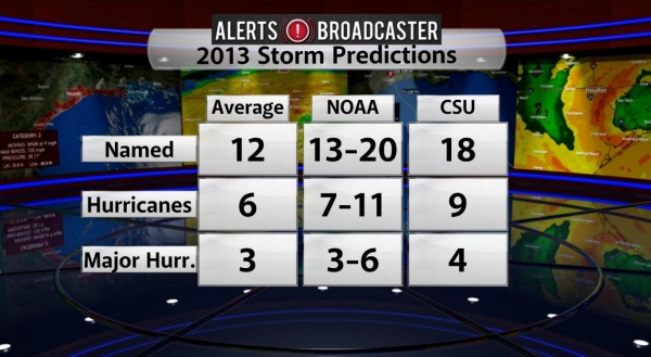
Altogether
NOAA predicts a 70% likelihood that 13 to 20 named storms—which
have winds that sustain at 39 mph or higher—will occur, of which 7
to 11 could become hurricanes (winds higher than 74 mph). Of those
three to six may become major hurricanes, which means Category 3 to
5, with winds above 11 mph. That’s all well above the average for an
Atlantic hurricane season, which lasts from June 1 to the end of
November. Why will this summer potentially be so stormy? For one, an
atmospheric climate pattern, including a strong African monsoon,
that’s been ongoing since 1995 will help supercharge the atmosphere
for tropical storms. Warmer-than-average water temperatures in the
tropical Atlantic and the Caribbean Sea will lead to more of the
wet, hot air that provides the fuel for hurricanes. And there is no
El Nino—the alternating climate pattern that means unusually warm
sea temperatures—which would usually suppress the formation of
hurricanes..."
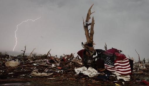
Photo credit above: "
Lightning in the sky over debris from the tornado that devastated Moore, Okla., Thursday, May 23, 2013." (AP Photo/Tulsa World, Mike Simons).
Hurricane Center Chief Focusing On Water Hazards. The power of moving water is overwhelming, as Sandy proved last year. Here's an excerpt from a story at
Ocala.com: "...
It
wasn’t just high winds that posed a threat and caused damage, said
National Hurricane Center Director Rick Knabb, who joined Florida’s
emergency managers earlier this month in Fort Lauderdale at the annual
Governor’s Hurricane Conference. “2012 was all about water, water,
water. Debby, Isaac, Sandy,” Knabb said. “It was storm surge from the
ocean, it was inland flooding, it was river flooding.” The hurricane
center has been working for several years to improve its storm surge
forecasts and public warnings about potential flooding risks far from
the coastline. The last season has added a sense of urgency to get
those upgrades ready by the 2015 season, Knabb said..."
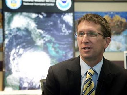
Photo credit above: "
National Hurricane Center Director
Rick Knabb talks this month in Fort Lauderdale about the lessons
learned from Hurricane Sandy and expectations for the Atlantic storm
season that begins Saturday. Knabb and hurricane center forecasters
joined emergency managers at the annual Governor’s Hurricane Conference." (The Associated Press)
2013 Atlantic Hurricane Season Expected To Be Active.
2012 saw 19 named storms, the 3rd busiest year on record. The last
major hurricane to hit the USA was Wilma in 2005. That 7 year stretch
(of no category 3+ hurricanes) is the longest on record, so we are
overdue for a significant hurricane landfall. NOAA came out with their
official predictions on Thursday; based on a variety of factors it
promises to be a very active hurricane season, details via
Climate Matters: "
NOAA
released its annual Atlantic Hurricane Season Predictions.
Meteorologist Paul Douglas shares the factors forecasters consider when
coming up with their numbers. What do you think of NOAA's
predictions?"
Here's an excerpt from from one of my corporate
Alerts Broadcaster Outlooks (issue Saturday morning):

Predicting hurricane track & intensity is as much art as
science; knowing which models to trust, and when. My meteorology
professors at Penn State would cringe to hear me say this, but
intuition and past history can play as big a role as model trends.
Predicting hurricane potential 3-4 months from now is equivalent to
forecasting what financial markets will be doing in late summer. Good
luck with that. But there are factors that lead me to believe that
this will be another above average year for tropical storms and hurricanes
in the Atlantic basin, with as many as 2-3 hurricanes hitting the
U.S. coastline by October. Here's the logic behind that prediction:
*
Hurricane Cycle. There is a natural 25-40 year
cycle for hurricanes - we entered the busy/active part of that cycle in
the mid-90s, so this is a significant factor.
*
Warm SST's. Sea surface temperatures are warmer
than average, to the tune of 1F. That may not sound like much, but
hurricanes get their strength from warm ocean water, and every 1F. of
warmth increases hurricane potential by 5-10%
*
No El Nino To Save Us. El Nino warming phases in
the equatorial Pacific tend to increase winds over the tropics; more
wind shear shreds developing tropical storms, reducing the threat of
hurricane development in the Atlantic and Gulf of Mexico. Right now
we are in an ENSO-neutral state, meaning no El Nino or La Nina in the
Pacific.
*
Feeling Lucky? The last major (category 3 or
stronger) hurricane to strike the USA was Wilma in 2005. The
intervening 7 year stretch with no category 3+ hurricane is the longest
on record for the USA. Last October we saw what a category 1 storm,
Sandy, coming at high tide and a full moon can do. Jet stream winds
are more erratic this year, more sweeping north/south dips and bulges
to prevailing steering winds aloft, which increases the potential
for tropical systems to penetrate unusually far north.
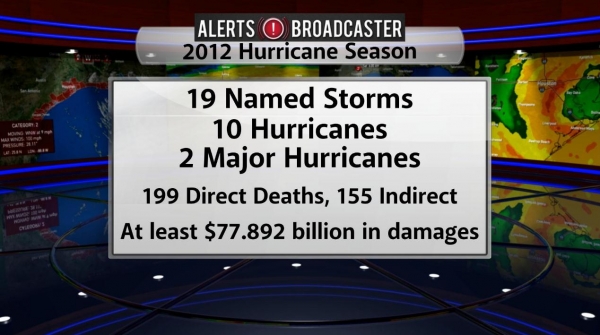
2012 Recap. Last year was very active in the
Atlantic basin with 19 tropical storms; 10 strengthened into
hurricanes; 2 of those became major hurricanes (but remained out at
sea). Damage estimates vary, but generally run in excess of $70
billion, the vast majority of that from Sandy.
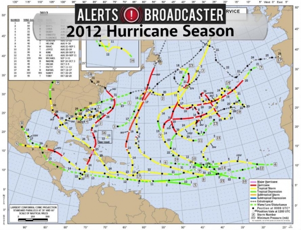
2012 Tropical Systems. NHC confirms 19 named
storms, the 3rd highest number on record in the Atlantic basin.
Mercifully most of those tropical storms and hurricanes remained out
over the open waters of the North Atlantic.
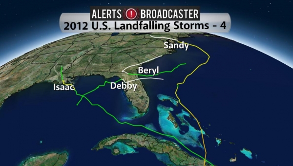
2012 U.S. Landfalling Storms. Only Isaac was a
full-fledged hurricane as it hit the U.S. coastline. Debby and Beryl
were tropical storms, and Sandy was "extra-tropical", technically not a
warm-core hurricane as it came ashore - although the distinction was
probably lost on waterlogged residents of New Jersey and metro New
York. In fact NOAA got a lot of grief for discontinuing Hurricane
Warnings before Sandy's landfall - this send the wrong message to
coastal residents who assumed the storm was weakening. Sandy was a
hybrid storm, a slowly weakening hurricane that was energized by a
Nor'easter, mutating into a storm 3 times larger than Katrina in 2005.
Slow movement and astronomical forcings whipped up a 900-mile wide
band of tropical storm force winds, the largest ever recorded,
compounding the storm surge problems for the northeast coast.
2013 Hurricane Prediction. I tend to agree with
both NOAA and CSU, Colorado State University, that we will experience
more hurricanes than usual again this year. The big question: will
prevailing winds guide those storms into the U.S. - or whisk them out
to sea, as was the case last year. For a variety of reasons, including
a more amplified north/south jet stream pattern (less of a westerly
wind bias aloft) I believe a higher percentage of tropical storms and
hurricanes will impact the Caribbean and U.S. in 2013. NOAA predicts
7-11 hurricanes, above the annual average of 6, and 3-6 major
hurricanes, category 3 or stronger.
* it's important to remember that, overall, climate change doesn't
seem to be triggering more hurricanes in the Atlantic, but since 1970
the number of category 3 or stronger hurricanes has roughly doubled;
it may be having a causal effect on hurricane intensity. Scientists
believe this may be linked to consistently warmer sea surface
temperatures. 90% of all warming is going into the oceans, and that has
implications for tropical development.
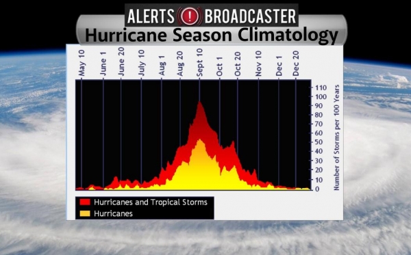
Hurricane Climatology. Think twice before booking a
Carnival Cruise on September 10, the date hurricanes are most likely
to reach the U.S. coastline, statistically. Atlantic basin
hurricanes have been observed every month of the year, but tend to
peak from late August into early October, when sea surface
temperatures in the Atlantic and Caribbean are warmest.
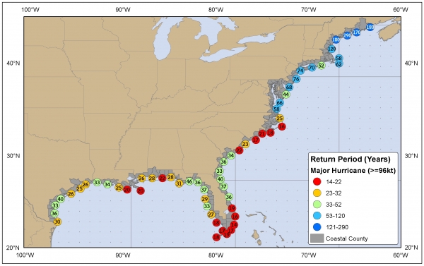
Return Frequence Of Major Category 3+ Hurricanes.
We compiled this map showing the probability of major (category 3 or
stronger) hurricanes along the U.S. coastaline. The red dots show the
locations of highest risk, based on past storm tracks: a return
frequency of 14-22 years for New Orleans, Mobile, much of south Florida
and the coastal Carolinas and Outer Banks.
Out On A Limb. Based on a variety of factors,
including prevailing winds, SST's, climatology and historical analogs,
this is my forecast for overall hurricane risk level in 2013; the
greatest potential for landfalling hurricanes and tropical storms from
south Florida northward to Savannah, Hilton Head and Charleston,
South Carolina. A moderate risk for landfalling hurricanes exists
from Galveston and New Orleans eastward to Mobile and Pensacola, with
a low to moderate risk from Virginia's Tidewater northward to Long
Island and Cape Cod.
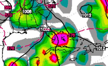
An Early Visit From Andrea? Latest GFS runs don't
look quite as impressive as they did on Saturday, but there's still a
chance of a tropical depression or weak tropical storm impacting south
Florida around June 6. Map above courtesy of WSI.
As Need For New Flood Maps Rises, Congress And Obama Cut Funding. Here's an excerpt from
OPB News: "...
Congress
has cut funding for updating flood maps by more than half since
2010, from $221 million down to $100 million this year. And the
president’s latest budget request would slash funding for mapping even
further to $84 million — a drop of 62 percent over the last four
years. In a little-noticed written response
to questions from a congressional hearing, FEMA estimated the cuts
would delay its map program by three to five years. The program “will
continue to make progress, but more homeowners will rely on flood
hazard maps that are not current,” FEMA wrote"...
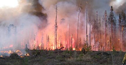
Sequester Cuts Wildfire Prevention, Sets Up Bigger Blazes.
Grist has another story that caught my eye - here's a portion: "...
Last year saw the third-worst wildfire season in five decades; the Southern California fire that threatened thousands of homes earlier
this month looks to be only the first flash of what the National
Oceanic and Atmospheric Administration announced last week will be an
above-average season for much of the Southwest. But the sequester took
a 7.5 percent bite out of the Forest Service’s budget, nearly half of which is
spent fighting wildfires. That means there will be 500 fewer pairs of
boots on the ground and 200,000 fewer acres treated to prevent fires;
the agency’s next proposed budget cuts preventative spending by a
further 24 percent..." (photo: DNR).
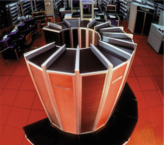
Weather Service To Add Major Might To Computing Power. With any luck I won't to rely on the European ECMWF model quite so much in the years ahead.
Kitsap Sun has the story - here's an excerpt: "...
After coming under fire for falling behind the capabilities of other nations,
the National Weather Service (NWS) is setting out to make an
unprecedented increase in its computing power over the next several
years, the agency announced this week. The computing boost will triple a
key measure of the agency's main weather model, and could yield major
improvements to its weather forecasting and warnings capabilities.
The program is made possible by recent funding from Congress contained
in the Hurricane Sandy
relief legislation, which was signed into law in January. The NWS
plans to use $25 million of the $48 million provided to it in the Sandy
supplemental bill, along with funds that are called for in President
Obama’s fiscal year 2014 budget proposal,
to bring about “unprecedented” computing upgrades — going from an
operational computing capacity of 213 peak teraflops at the end of the
current fiscal year, to 1,950 peak teraflops by the end of fiscal year
2015, according to NWS Director Louis Uccellini..."
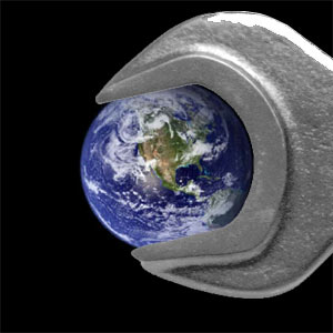
Climate Stories...
Geoengineering: Our Last Hope, Or A False Promise? Tinkering with the atmosphere on a global scale - what can possibly go wrong? Here's a clip from an important
New York Times article on tinkering with the atmosphere, attempting to undo the impact of carbon pollution: "...
Geoengineering — the deliberate, large-scale intervention in the climate system to counter global warming
or offset some of its effects — may enable humanity to mobilize its
technological power to seize control of the planet’s climate system, and
regulate it in perpetuity. But is it wise to try to play God with the
climate? For all its allure, a geoengineered Plan B may lead us into an
impossible morass. While some proposals, like launching a cloud of
mirrors into space to deflect some of the sun’s heat, sound like
science fiction, the more serious schemes require no insurmountable
technical feats. Two or three leading ones rely on technology that is
readily available and could be quickly deployed..."
Century-Old Science Helps Confirm Global Warming. Here's an excerpt from
NASA's Jet Propulsion Laboratory: "
A
new NASA and university analysis of ocean data collected more than 135
years ago by the crew of the HMS Challenger oceanographic expedition
provides further confirmation that human activities have warmed our
planet over the past century. Researchers from the University of
Tasmania, Sandy Bay, Australia; and NASA's Jet Propulsion Laboratory,
Pasadena, Calif., combined the ship's measurements of ocean
temperatures with modern observations from the international Argo array
of ocean profiling floats. They used both as inputs to
state-of-the-art climate models, to get a picture of how the world's
oceans have changed since the Challenger's voyage..."
Image credit above: "
Drawing
of the HMS Challenger survey vessel preparing to measure ocean
temperatures by lowering thermometers deep into the ocean on ropes in
1872. A new NASA and University of Tasmania study combined the ship's
135-plus-year-old measurements of ocean temperatures with modern
observations to get a picture of how the world's ocean has changed
since the Challenger's voyage. The research reveals that warming of
Earth can be clearly detected since 1873, with the ocean absorbing the
majority of the heat." Image credit: NOAA.
From Global Warming To Flouride: Why Do People Deny Science? Salon has a good story about the roots of denial; here's an excerpt: "...
Why
is it that ordinary citizens do not sit up and take notice of the
danger? Unfortunately, the focus remains mostly on “global warming”
instead of on the bigger concern—that we are disrupting the planet’s
climate in completely unpredictable ways. Because climate prediction
includes a significant degree of scientific uncertainty, this has
allowed skeptics to gain the upper hand and even corner some expert
scientists into difficult positions. A friend in the climate research
field privately admits that he and most of his colleagues are afraid to
stand up and speak out because of the vituperative attacks and massive
smear campaigns that they would inevitably suffer—as did Michael Mann
and others. But much research indicates that as forests disappear and
polar ice caps melt, etc., there are unpredictable feedback
mechanisms that will make global warming increasingly difficult to
tackle. Even more worrisome, there will likely be a tipping point
after which continued warming may become irreversible, no matter what
we do..."
Photo credit: "
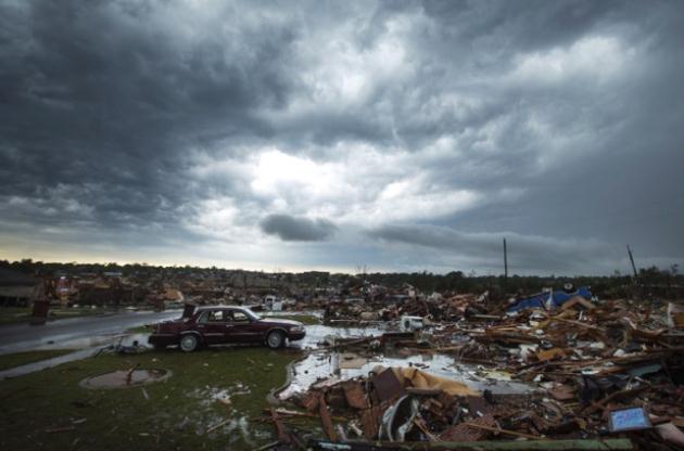
The clouds of a thunderstorm roll over neighborhoods heavily damaged in a tornado in Moore, Oklahoma, May 23, 2013." (Credit: Reuters/Lucas Jackson)
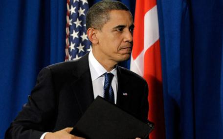
Where Is President Obama's Climate Agenda? Here's the intro to a story from
Politico:
"President Barack Obama began his second term with a ringing pledge to
tackle climate change — saying that “the failure to do so would
betray our children and future generations.” Four months later,
everyone’s still waiting. Instead of taking bold steps, Obama’s
environmental regulators are dodging questions about how they intend
to rein in the nation’s largest sources of greenhouse gases. They
missed a major deadline last month for rolling out rules for future
power plants, prompting environmental groups and several states to
threaten lawsuits. And the EPA has insisted to Congress that it’s not
even working on regulations for the next piece of the carbon puzzle —
the nation’s vast fleet of existing power plants..."
Photo credit: Politico, AP.
Insurers And Climate Change: The Truth Is More Complicated Than The Sound Bytes.
Insurance Journal has the story - here's a clip: "...
On
one hand, if one doubts the opinion of an overwhelming majority of
scientists, the insurance industry provides another major data point.
Given that accurate and unbiased weather forecasts are key to property
insurers’ business, the fact that the industry broadly accepts that
climate change is real and likely to be a problem should be taken
seriously by anyone who believes in the power of markets to aggregate
information. If insurers were not concerned about climate change, that
would be a very strong piece of evidence that politicians, the media
or scientists have hyped the issue beyond what it deserves. In fact,
every large property insurer incorporates climate change-related
projections into its own models. Every large property insurer that I
know of considers the likelihood of climate change-linked catastrophes
to be a future operational threat. Smaller property insurers do less
long-term planning and are less likely to make direct use of climate
change projections, but they still feel the impact of those
projections in terms of how much reinsurance they can buy and at what
price..."