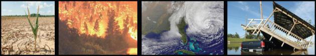
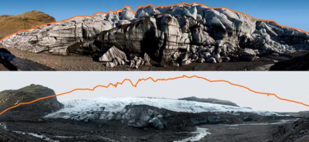
Jet stream 2.0
People are asking about recent weather extremes:
record drought to historic floods, virtually overnight - 18" snows in
May? "Is this the new normal?" Time will tell, but researchers
increasingly see a link with recent melting in the Arctic. If you've
seen the documentary film "Chasing Ice" you know what I'm referring to:
1.3 million square miles of ice lost in 30 years. Warming at the top of
the world may be reducing temperature contrasts, turning the jet stream
into a "sluggish estuary", according to Rutgers researcher Jennifer
Francis.
As jet stream winds slow weather patterns can
slow down and even stall, with more of a north-south component to wind
patterns evident since record melting in 2012. Details below.
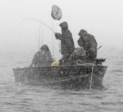
A rumble of thunder today gives way to light
rain Thursday. A gusty cool front arrives Saturday; highs in the 50s
with a rising barometer. Not sure the walleye will be biting, but it's
worth a shot.
Mother's Day looks better: bright sun, less wind - highs near 60F. No accumulating snow in sight.
Models hint at 80s next Tuesday, but no
sustained heat or humidity is brewing either. A big silver lining: May 8
and there have been no severe storms near the metro yet.
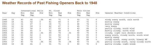
Fishing Opener Weather Over The Years. Pete Boulay at the
Minnesota Climatology Working Group has a great overview of past weather for Minnesota's Fishing Opener; here's an excerpt: "
Minnesota's
Fishing Opener weather is typified by partly cloudy to cloudy skies,
morning temperatures in the low 40's, and afternoon temperatures
climbing to near 70. Three out of four years are free of measurable
precipitation. A trace of snow has been reported in northern Minnesota
on at least five of the last 64 fishing openers. On at least four
occasions, some lakes were still frozen for the opener. Generally there
is enough wind to be felt on the face, maybe enough to 'fly' a flag.
Weather on Minnesota fishing opener dates is highly variable. 64 years
of fishing opener weather data are summarized here to offer a glimpse of
what is 'typical' and what is 'extreme'.
Opening day temperatures have started as low as 24 degrees at
International Falls (1996,2004), with freezing temperatures possible
even in Minneapolis (31 degrees in 1979). On the warm side, St. Cloud
saw 92 degrees in 1987, Minneapolis reported 91 in 1987, and
International Falls reached 88 in 1977. The average early morning
temperature varies from the high 30's in the northeast to the high 40's
along the southern border. The average afternoon temperature generally
ranges from the mid 60's along the northern border, to the low 70's in
the extreme south. Along the shore of Lake Superior, highs are held in
the mid 50's..."
Fishing Opener Weather Back To 1948. Sure, it's more than you ever wanted to know, but if you're really bored, troll through this page from
The Minnesota Climatology Working Group to see how much worse it could be this weekend.
Governor's Fishing Opener.
The Minnesota Historical Society has more details on why our governors probably live in mortal dread of The Fishing Opener.
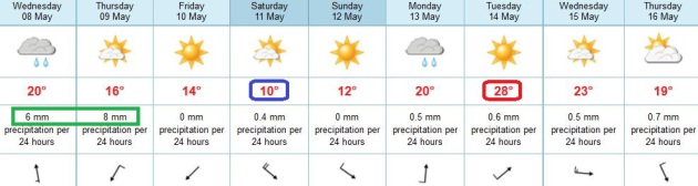
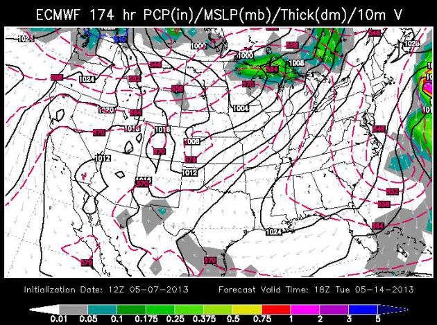
May (Mostly). ECMWF data suggests Thursday may be a
little wetter than today; skies dry out Friday - a few fleeting showers
Friday night as cooler air arrives. Saturday should be the chilliest
day: 50s south and some upper 40s far north. Winds ease Sunday with
bright sun and highs in the mid 50s to near 60F. The Euro suggests 80s
by Tuesday, then cooling off a bit the latter half of next week.
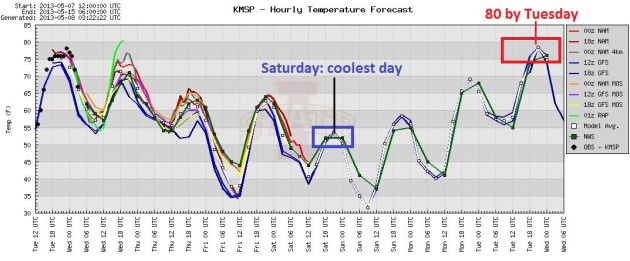
Slight Relapse. We cool off over the weekend, but
the U.S. models agree with the ECMWF simulation, showing a nice, almost
summerlike spike in temperature by Tuesday. Graphic: Iowa State.
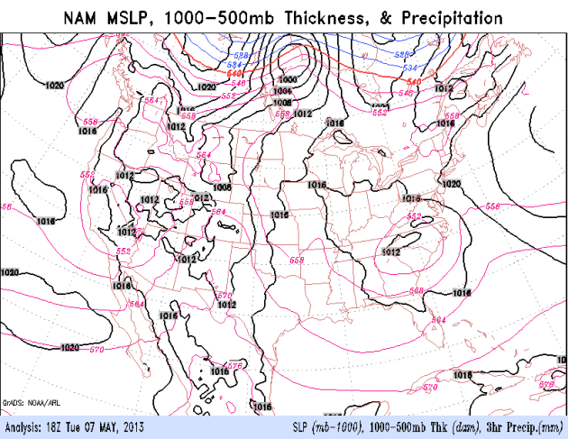
84 Hour NAM Model. Pacific moisture (that helped to
quench widlfires in California) will spread into Minnesota and the rest
of the Upper Midwest today; a few claps of thunder possible. Showers
spread up the east coast from a weakening cut-off low. By Saturday a
shot of chilly air is poised to sweep into the Upper Mississippi Valley
and Great Lakes. No, don't pack away the light jackets just yet.
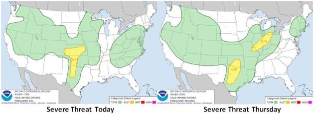
Slight Severe Risk. Hail and isolated tornadoes are
possible later today from Kansas into western Oklahoma and central
Texas. Thursday the risk remains from Dallas to Oklahoma City; another
risk area from St. Louis to Indianapolis and Detroit. Source: NOAA SPC.
Warming Trend. The European model forecast for
midday Tuesday (courtesy of WSI) shows a surge of warm air pushing into
southern and central Minnesota. Assuming the sun is out we should have
no problem topping 80F, followed by a cooler front by Wednesday.
Why Our Turbulent Weather Is Getting Even Harder To Predict. Amen to that. Changes in the Arctic may be having a ripple effect at lower latitudes, as described in this article at
The Guardian; here's an excerpt: ..."
As
the Arctic heats up disproportionately, so does the atmosphere at the
north pole and as it warms up, it rises. The net effect has been to
erode the gradient between the top of the atmosphere over the tropics
and the top of the atmosphere over the Arctic. Less air pours down
towards the north pole and less air is whipped up by Earth's rotation to
form the jet stream. It is becoming less of a stream and is behaving
more like a sluggish estuary that is meandering across the upper
atmosphere at middle latitudes." The effects of this meandering are now
being felt. As the jet stream slows, weather patterns tend to stick
where they are for longer. In addition, the modest waves in the stream
have increased in amplitude so that they curve north and south more
frequently, bringing more weather systems northwards and southwards.
Hence the cold conditions that have been brought south over Britain and
which have persisted for so long..." (Photo: Kevin Gould, NASA Earth Observatory).
This Isn't The Weather We Grew Up With. Everyone
wants a nice, tidy, 10 second TV soundbite explanation for why our
weather has gone mad. Connecting the dots is a bit more complicated than
that, but here's a good place to start, a story at
The Guardian, co-authored by University of St. Thomas climate scientist John Abraham. Here's an excerpt: "
What
does this mean to us? It means that we shouldn't be surprised to see
more severe weather that lasts for longer durations. Our weather can
be expected to whiplash from one extreme to another. In the U.S. we are
seeing some evidence of this. Alternating wet, snowy winters and warm
non-winters. Summers of either extreme heat and drought – or
unbelievable flooding. But don't just take my word for it. A leading
researcher in this area, Dr. Jennifer Francis says,
"The Arctic is warming two-to-three times faster than the rest
of the northern hemisphere -- the loss of sea ice, spring snow cover,
increased Greenland melting, and permafrost degradation are all
symptoms of and contributors to this warming. It's inconceivable that a
change of this scale and magnitude will not have substantial impacts
on the atmosphere, ocean, and land both within the Arctic and also
beyond the Arctic where millions of people live. These impacts will
affect not only the physical system -- such as weather patterns and
ocean circulation -- but also life on land and in the ocean. Exactly
how these effects play out is a wide-open topic of research..."
Photo credit above: Climate Nexus.
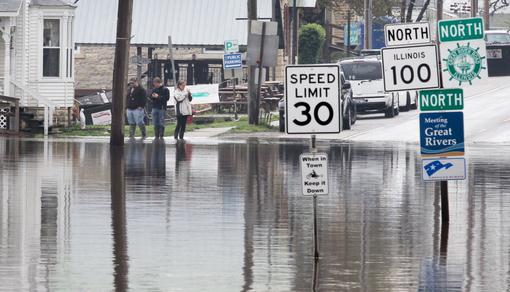
Farmers Whipsawed By Drought, Then Rain Across Region. Here's an excerpt from
St. Louis Today: "
Farmers
had crossed their fingers and said their prayers. But then they got
what they wanted. A decimating drought last year ravaged the country’s
corn crop and had farmers nervously hoping for a snowy winter or rainy
spring to replenish parched farmland. But now, after weeks of
above-average rain, much of the nation’s corn belt is a muddy mess,
leaving farmers frustrated and planting weeks behind schedule,
potentially cutting into this year’s expected record crop. “It’s just
mud out there. There’s no chance, whatsoever, of getting anything
done,” said Greg Guenther, who grows corn east of Belleville.
“Everyone’s worried and annoyed, because it really should be in the
ground, and we should be planting beans by now. Instead we’re just
looking at muddy fields...”
Photo credit above: "
Water covers the intersection of Illinois State Route 100 and Route 3 in Grafton, Illinois, on April 23, 2013." (Derik Holtmann/Belleville News-Democrat/MCT)
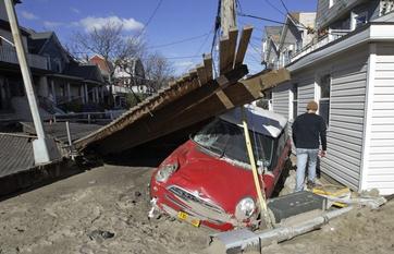
The Government Is Spending Way More On Disaster Relief Than Anybody Thought. There is no Magic Money Genie - at some point the cost of all these disasters trickle down to all of us.
The Washington Post Reports: "
Hurricanes, floods and droughts are putting an increasingly large strain on the federal budget. A new report
out Monday from the Center for American Progress finds that Congress
spent at least $136 billion on disaster relief between 2011 and
2013. That works out to $400 per household per year. And those costs
could rise in the years ahead — particularly if climate change leads to
more frequent extreme weather. But the most striking part of the
report? No one in the government even knew the full amount that
Congress had been spending on disaster relief — not the Federal
Emergency Management Agency, nor the Office of Management and Budget.
The authors had to pore over all the appropriations bills and
disaster-relief supplementals that Congress had passed between fiscal
year 2011 and fiscal year 2013 to make an estimate..."
Photo credit: "
As storm cleanup continues in the Rockaways
neightborhood of New York, a man walks by a piece of the Rockaways
boardwalk atop a car." (Kathy Willens / AP)
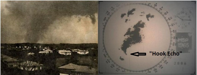
Minnesota's Deadliest Tornadoes. The Twin Cities National Weather Service has a
comprehensive summary
of the May 6, 1965 tornado outbreak with spun up F-4 tornadoes in the
immediate metro. Fridley was hit the hardest (by two separate F-4
twisters; winds approaching 200 mph). Here's an excerpt: "
The worst
tornadoes in Twin Cities history occurred in 1965, with five tornadoes
sweeping across the western and northern portions of the 7-county
region, and a sixth tornado just outside the metropolitan area. Four
tornadoes were rated F4, one was an F3, and the other produced F2
damage. Thirteen people were killed and 683 injured. Many more would
have been killed had it not been for the warnings of the U.S. Weather
Bureau, local officials, and the outstanding communications by local
radio and television stations. Many credit the announcers of WCCO-AM
with saving countless lives. It was also the first time in Twin Cities
history that civil defense sirens were used for severe weather...."
Image credit upper left: "
A photo taken by Minnetonka
resident H. B. Milligan of a tornado crossing to the west of the
junction of Hwy 7 and 101 on May 6, 1965. It is believed that this was
the tornado that touched down in Chanhassen at 6:27 p.m. and dissipated
in Deephaven at 6:43 pm. The photo was published in July 1965 by the
Minneapolis Tribune as part of the "Photos of the Week" feature, and
photographers received a $5 award."
Image credit upper right: "
Radar footage from 1965 was
recently discovered, and the 35mm film was converted to digital format,
although there was no method available to us other than a somewhat
crude technique. So we present them "as is," with little indication of
how distant the storm was from the radar, or without any map
backgrounds. It will take quite some time, but we hope some day to
assign high resolution map backgrounds and possibly filter the radar
echoes to highlight the most important storms. This will allow us to
study the event in greater detail and learn important lessons from this
historic tornado outbreak. The clock uses 24 hour timing, and is in
Central Standard Time. For example, 1800 would be 6:00 p.m. CST, and
2100 would be 9:00 p.m. CST."
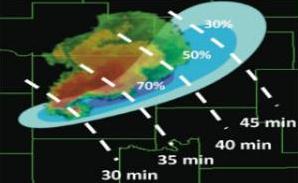
Warn On Forecast: Future of Weather Warnings. A
30-40 minute "Tornado Alert"? It's possible within the next 4-6 years.
Here's a good overview of NOAA's plans for tornado and severe storm
prediction in the years ahead from
KTBX.com: "...
He's
going about it by working on research that will hopefully bring on a
process called "Warn on Forecast." The idea is to forecast an individual
storm from before the time it becomes severe through an hour in the
future. Using a percentage basis, the theory is that a computer model
should be able to give us an idea where a tornado will be likely and
how it will move within that hour. After 5 minutes time, that same
model will recreate the forecast, taking in the newest data and radar
scans, and produce another updated forecast. Should a tornado be
possible, the percentage and confidence will increase and forecasters
should be able to issue a warning well ahead of the severe weather
event happening..."
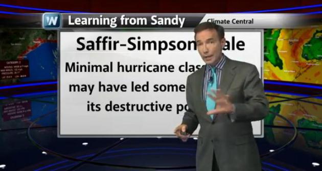
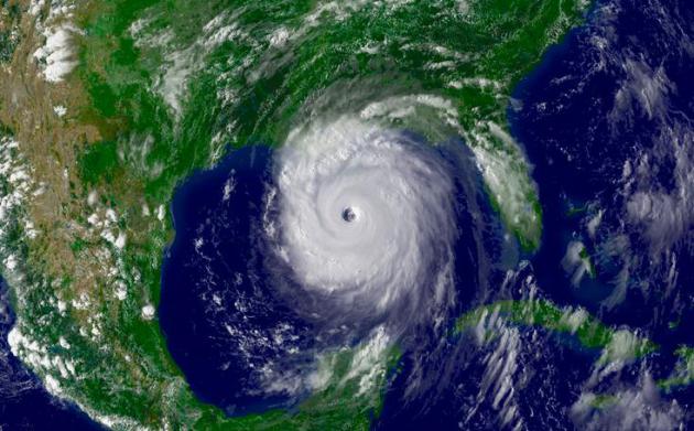
Hurricane Season Countdown: What We Learned In 2012.
Sandy was sobering on many levels. It turns out there may be a better
way to communicate the risk posed by a specific hurricane than the
Saffir-Simpson scale. Here's an overview of today's
Climate Matters video clip: "
Meteorologist
Paul Douglas previews the 2013 Atlantic hurricane season which is just
a few weeks away. Learn about a new scale called TIKE that could
compliment the Saffir-Simpson Scale."
Scientists Develop New Way Of Classifying Hurricanes. What is the "TIKE Index" and why should you care? Andrew Freedman at
Climate Central
reports on a new (and more accurate) way to measure the full impact of
hurricanes and their storm surges - the most damaging and deadly
component of these massive tropical systems. Here's an excerpt: "...
Now, a new study, published in the journal Monthly Weather Review
by scientists from Florida State University, proposes a new metric that
aims to complement Saffer-Simpson and other recently developed scales
by taking into account a storm's intensity, duration, and size. The
metric, known as "Track Integrated Kinetic Energy", or TIKE, builds from
an existing measure of storm integrated kinetic energy (IKE), which was
developed in 2007..."
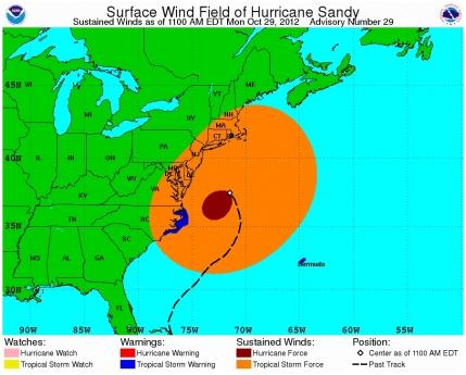
Graphic credit above: "
Hurricane
Sandy had a massive tropical storm force wind field that at one point
spanned the entire East Coast from North Carolina to Massachusetts." Credit: National Hurricane Center.
2012 Shows How Storm Predictions Can Miss The Mark.
Hurricane track forecasts are good, and getting better. Hurricane
intensity projections? Much more problematic. Here's an excerpt from a
story at
The Herald Tribune: "..
As
predictions go, 2012 was a good year — the NHC had a record-low margin
of error after verifying track predictions against the actual path of
storms. "Two-thousand twelve was a successful year, no matter how you
look at it," National Hurricane Center specialist John Cangialosi told
conference attendees. But calculating storm intensity proved less
reliable, and when the models were off, the consequent devastation to
unsuspecting coastal areas overshadowed any statistical victory. "We do
still make some occasional, big-time mistakes," he added. "There's no
better way to see that than to look at last year..."
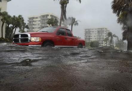
Photo credit above: "
Motorists drive through a flooded
section of Beach Road near Siesta Key Public Beach on une 28, 2012
after rain from Tropical Storm Debby filled streets and parking lots
with water on the Sarasota barrier island." HERALD-TRIBUNE ARCHIVE / 2012 / ELAINE LITHERLAND
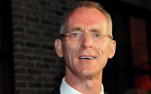
Hurricane Center Director: Water, Not Wind, Caused Most Serious Problems In 2012 Storm Season.
Never underestimate the power of rapidly moving water. People tend to
fixate on a hurricane's "category" (1-5) and wind speeds, when what they
should really be focused on is storm surge potential. Here's an excerpt
from AP and
The Washington Post: "
Last
year’s hurricane season drove home some big lessons, the nation’s
chief hurricane forecaster said Tuesday: Storm surge and flooding are
dangerous and difficult to predict, and sometimes it’s even harder to
communicate that sense of urgency to the public. It wasn’t just high
winds that posed a threat and caused damage, said National Hurricane
Center Director Rick Knabb, who joined Florida’s emergency managers in
Fort Lauderdale at the annual Governor’s Hurricane Conference. “2012
was all about water, water, water. Debby, Isaac, Sandy,” Knabb said.
“It was storm surge from the ocean, it was inland flooding, it was
river flooding...”
Photo credit above: J Pat Carter - Associated Press. "
National
Hurricane Center Director Rick Knabb talks, Tuesday, May 7, 2013 in
Fort Lauderdale, Fla, about the lessons learned from Superstorm Sandy
and expectations for the Atlantic storm season that begins June 1..."
In The Market For A Flying Car? Looks like science fiction may become a reality in the very near future. Check out this article at
gizmag.com: "
Although countless small companies have tried to commercially develop flying cars
over the past several decades, we’re still not seeing Blade
Runner-esque vehicles cruising over our rooftops ... yet. Terrafugia is
one of the groups currently trying to change that situation – a
fully-functioning prototype of its Transition
fixed-wing “roadable airplane” is currently undergoing flight tests,
and was recently cleared for civilian use by the US Federal Aviation
Authority. It still requires a runway for take-off and landing, though,
which kind of clashes with many peoples’ flying car fantasies. Well,
today Terrafugia announced its plans for a hybrid-drive
vertical-take-off-and-landing (VTOL) vehicle, known as the TF-X..."
Photo credit above: "
Terrafugia has announced its plans to develop a vertical-take-off-and-landing flying car, known as the TF-X." (Image: Terrafugia)
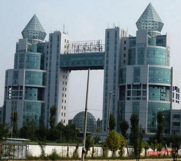
China's Architecture Just Keeps Getting More Bizarre. Here's an excerpt from an article at
Quartz: "...
Bizarre buildings have increasingly been piercing China’s skylines, earning the country a reputation for being “a playground for bad design.”
Unattractive Chinese buildings have become so commonplace that a
Chinese architectural firm, Archcy, has started surveying residents on
what they believe are the country’s 10 ugliest buildings (article in Chinese). One architect last year said choosing just 10 was “very hard” but a million he could do..."
Photo credit above: "
The Guiyang Science and Technology building in Guizhou, China has been voted one of the ugliest buildings in China in 2013." archcy.com
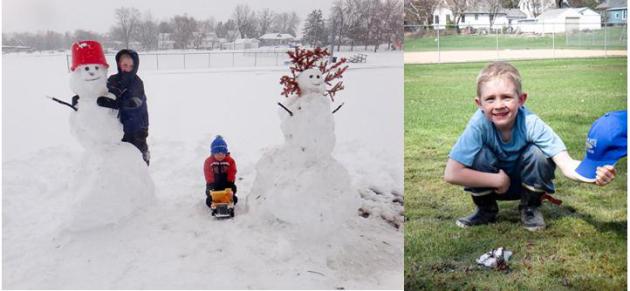
A Snowman's Rapid Demise. Thanks to Andrew and Jill
Dahl (hey, any relation to...never mind) for sending in these before and
after photos from southeastern Minnesota. The photo upper left was
taken Thursday, May 2. The photo on the right was taken just 96 hours
later. This has to be some sort of record for the fastest snowman
meltdown on record.
 Climate Stories....
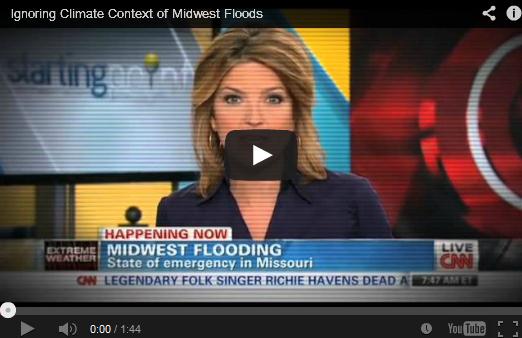
Video: What The Press Is Missing About Midwest Floods
Climate Stories....
Video: What The Press Is Missing About Midwest Floods. Here's an excerpt from
Media Matters: "
As Midwestern states assess the damage wrought by record flooding
in recent weeks, scientists tell Media Matters that the media has
missed an important part of the story: the impact of climate change. A
Media Matters analysis
finds that less than 3 percent of television and print coverage of the
flooding mentioned climate change, which has increased the frequency
of large rain storms and exacerbated flood risks. Seven out of eight
scientists interviewed by Media Matters agreed
that climate change is pertinent to coverage of recent flooding in the
Midwest. Princeton University climate scientist Michael Oppenheimer
told Media Matters it is "not only appropriate, but advisable" for the
press to note that rainstorms in the Midwest are increasing
in frequency and that climate models "suggest this trend will
continue," which will contribute to more flooding. Aquatic ecologist Don
Scavia added that this is the "new normal," and that the media is
"missing an important piece of information" by ignoring this trend..."
Arctic Ocean "Acidifying Rapidly". Here's an excerpt from a story running at
The BBC: "
Scientists from the Arctic Monitoring and Assessment Programme (AMAP) monitored widespread changes
in ocean chemistry in the region. They say even if CO2 emissions
stopped now, it would take tens of thousands of years for Arctic Ocean
chemistry to revert to pre-industrial levels. Many creatures, including
commercially valuable fish, could be affected. They forecast major
changes in the marine ecosystem, but say there is huge uncertainty over
what those changes will be..."
Can Humans Survive? Newsweek has the story - here's a clip: "...
No
matter what we do to control our fossil-fuel use and carbon output,
our climate has already been permanently changed for the next
millennium. To prevent the planet from becoming uninhabitable, we’ll
have to take our control of the environment a step further and become
geoengineers, using technology to shape geological processes. Though
“geoengineering” is the proper term here, I use the word “terraforming”
because it refers to making other planets more comfortable for humans.
As geoengineers, we aren’t going to “heal” the earth or return it to a
prehuman “state of nature.” That would mean submitting ourselves to the
vicissitudes of the planet’s carbon cycles, which have already caused
several mass extinctions. What we need to do is actually quite
unnatural: we must prevent the earth from going through its periodic
transformation into a greenhouse that is inhospitable to humans and the
food webs where we evolved. Put another way, we need to adapt the
planet to suit humanity."
Photo credit above: "
Are we in the first act of a mass
extinction that will end in the death of millions of plant and animal
species across the planet, including us?" (Eric Prine/Gallery Stock)
With Carbon Dioxide Approaching A New High, Scientists Sound The Alarm. 400 ppm. Here's an excerpt from
The International Herald Tribune: "
For the first time in human history, atmospheric carbon dioxide levels will surpass 400 parts per million, according Scripps Institution of Oceanography, which has been measuring carbon dioxide in the atmosphere at the Mauna Loa volcano in Hawaii
since 1958. “The 400-ppm threshold is a sobering milestone, and should
serve as a wake-up call for all of us to support clean energy
technology and reduce emissions of greenhouse gases, before it’s too
late for our children and grandchildren,” said Tim Lueker of the
Scripps Institution in a statement. The level of carbon dioxide in the
atmosphere is closely linked to global warming. The more carbon
dioxide, the higher global average temperatures have climbed, according
to climate science. (This graphic shows how global temperature and atmospheric carbon dioxide levels have been linked in the past 400,000 years)..."
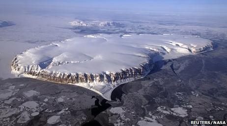
Arctic Melting Rapidly: Action Needed Now. If you
haven't seen the documentary "Chasing Ice" - and you still have an open
mind about climate change, spend the time, make the effort to see this
film. It may change the way you feel about this subject. Some people
still don't trust climate scientists. Hopefully they'll believe their
own eyes. Here's an excerpt from a
Huffington Post story: "
The Arctic sea ice is melting at a phenomenal rate and the London-based Arctic Methane Emergency Group (AMEG)
is calling for governments to put two and two together, and pull out
all stops to save the Arctic sea ice or humankind will face starvation
in the ensuing years ahead. This week, the White House will hear
evidence from Australian scientist, Carlos Duarte, that the Arctic sea
ice is on such a downward spiral that we may see a dramatic decline of sea ice over the next two years. Evidence
was given to the UK government last year from British scientists,
Peter Wadhams and John Nissen, that we could see minimal sea ice by
September 2015, simply extrapolating the sea ice volume trend.
Evidence from recent satellite images suggests that a record melt is in
progress this year. The plight of the Arctic was highlighted
to British MPs and the Met Office in a recent showing of the film
"Chasing Ice" at the House of Commons, London. The Arctic has recently
become an issue in the European Parliament..."
Suit Claiming Hurricane Katrina Related To Global Warming Goes Before Appeals Court.
Think Philip Morris (time 10,000). Nothing diminishes shareholder
confidence in fossil fuel companies faster than class action lawsuits.
Can the plaintiffs prove that higher greenhouse gas levels (and warmer
water in the Gulf of Mexico) fueled Katrina's explosive intensification
into a Category 4-5 storm in the Gulf of Mexico? Keep an eye on this one
and more to come; details from
The Louisiana Record: "
The
U.S Court of Appeals for the Fifth Circuit is set to issue its second
opinion in a drawn out climate change case that pits landowners against
energy companies. The suit, which accuses a number of companies of
contributing to global warming through greenhouse gas emissions, was
originally filed in a Mississippi district court in 2005 just 22 days
after Hurricane Katrina hit. In the original filing, 14 plaintiffs sued
eight named oil companies, 100 unnamed oil and refining companies and
31 coal companies. Through the course of the litigation, electric
utilities and chemical companies have been added as defendants. The
plaintiffs claim that there is a causal relationship between the
emissions, which increased the ferocity of Hurricane Katrina, and the
resulting destruction of their property. Multiple defendants in the suit
moved for a dismissal, alleging that the plaintiffs lacked standing
and that their claims presented nonjusticiable political questions..."
Bob Ingliss Going The Distance On Carbon Emissions Tax.
Bob Ingliss is a notable Republican, which makes his initiative
significant. He proposes putting a price on greenhouse gas pollution,
but in a way that is revenue neutral; a way that stimulates the economy
without growing the size of government. Here's an excerpt from
Politico: "
Former
Rep. Bob Inglis knows that his devotion to a carbon tax might have cost
him his job. But the South Carolina Republican has no regrets as he
dedicates his post-congressional career as well to the battle to
persuade fellow conservatives to embrace a revenue-neutral carbon tax.
“And really, I am the worst commercial for this, because I got my head
blown off trying to do it,” he told POLITICO, sitting at a coffee shop a
short walk from the Capitol. But he added, “Losing an election is not
the worst thing that can happen to you. Losing your soul is
considerably worse.” The controversial tax proposal has long won the
backing of many economists, who say it is the simplest and purest means
of reducing emissions blamed for contributing to climate change. And
while it has also won tentative backing from oil giants like Shell and
ExxonMobil, it’s been pilloried by many oil-state politicians and
conservatives, who say it would raise energy costs and hurt fossil fuel
industries..."