Jackets and Shorts
There is a natural pace to the weather; cold and warm air advancing and retreating, like ocean waves on the beach.
Lately those tsunami-like waves have been
breaking faster & harder: 145 Minnesota tornadoes in 2010, record
heat/drought in 2012, 18 inch April snows & icy Fishing Openers in
2013? It feels like Mother Nature is swerving down the highway,
careening from one extreme to the next.
Case in point: this week. We go from frost up
north Sunday to Fire Weather Watches today to 90F Tuesday. A Fire Watch
means low humidity and 40 mph winds may fan fast-moving wildfires,
especially Tuesday afternoon. T-storms may pop up here later today; a
sudden surge of heat & moisture may spark a few severe T-storms
tomorrow over Wisconsin.
Highs approach 90F tomorrow before cooling off
later this week. It's still a wet pattern; showers return late week with
potentially heavy rain next weekend - especially Sunday.
The pattern still looks like something out of
April. Sustained hot weather has been delayed - I still expect a cooler,
wetter, stormier summer than 2012.
Sick of "Sprinter" (an unholy marriage of spring
& winter?) A chilly bias means we're spending less time hiding in
basements. No MN tornadoes as of May 13.
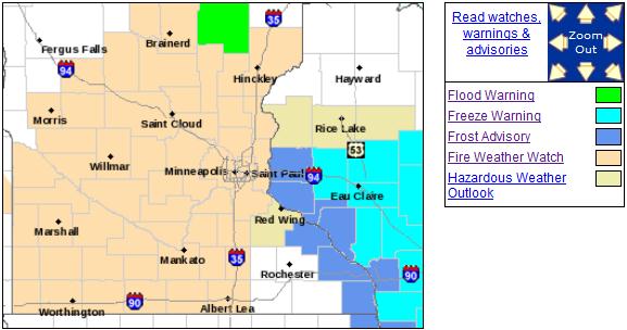
Fire And Ice. What a mixed-up weather map. Frost
Advisories and Freeze Warnings far southeastern Minnesota and Wisconsin,
while a Fire Weather Watch is posted for Tuesday, when 90F.
temperatures and low humidity may combine with strong 20-40 mph
southwest winds to increase the potential for rapidly moving brushfires.
Details from the Twin Cities National Weather Service:
...FIRE WEATHER WATCH FOR MUCH OF CENTRAL INTO SOUTH CENTRAL MINNESOTA
TUESDAY AFTERNOON INTO TUESDAY EVENING...

.HOT WEATHER CONDITIONS WILL ARRIVE TUESDAY...WITH TEMPERATURES
EXPECTED TO REACH THE MID 80S TO MID 90S. RED FLAG CONDITIONS
APPEAR LIKELY FROM WEST CENTRAL INTO SOUTH CENTRAL MINNESOTA
TUESDAY AFTERNOON AS MINIMUM RELATIVE HUMIDITY NEARS 25 PERCENT
AND COMBINES WITH SOUTH TO SOUTHWEST WINDS AROUND 20 MPH.
DEWPOINTS ARE EXPECTED TO BE INCREASING ON TUESDAY AFTERNOON...BUT
THERE REMAINS UNCERTAINTY ON HOW HIGH. IF DEWPOINTS CAN INCREASE
HIGHER THAN THE LOWER TO MID 50S THAT ARE CURRENTLY ANTICIPATED ON
TUESDAY AFTERNOON...THE FIRE DANGER COULD BE LESSENED SOMEWHAT.
ISOLATED SHOWERS AND THUNDERSTORMS ARE ALSO POSSIBLE TUESDAY
EVENING...MAINLY FROM SOUTH CENTRAL MINNESOTA INTO WEST CENTRAL
WISCONSIN.

...FIRE WEATHER WATCH IN EFFECT FROM TUESDAY AFTERNOON THROUGH
TUESDAY EVENING FOR WIND AND LOW RELATIVE HUMIDITY FOR MUCH OF CENTRAL
INTO SOUTH CENTRAL MINNESOTA...

THE NATIONAL WEATHER SERVICE IN TWIN CITIES/CHANHASSEN HAS ISSUED
A FIRE WEATHER WATCH FOR WIND AND LOW RELATIVE HUMIDITY...WHICH
IS IN EFFECT FROM TUESDAY AFTERNOON THROUGH TUESDAY EVENING.

* WINDS...STRONG SOUTH TO SOUTHWEST WINDS BECOMING WEST 15 TO 25
  MPH WITH GUSTS UP TO 40 MPH.

* RELATIVE HUMIDITY...AS LOW AS 22 PERCENT.

* IMPACTS...WILDFIRES COULD BECOME FAST MOVING IN A SHORT PERIOD
  OF TIME DUE TO THE STRONG WINDS...LOW HUMIDITY AND DRY FUELS.

PRECAUTIONARY/PREPAREDNESS ACTIONS...

A FIRE WEATHER WATCH MEANS THAT CRITICAL FIRE WEATHER CONDITIONS
ARE FORECAST TO OCCUR. LISTEN FOR LATER FORECASTS AND POSSIBLE
RED FLAG WARNINGS.
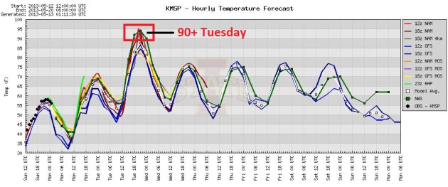
Heat Spike. All the models show 90-degree-plus highs
Tuesday afternoon. The only thing that could cool us off would be
convection: scattered T-storms, which are most likely tomorrow over
Wisconsin. Temperatures cool back down closer to average the latter half
of this week. Graphic: Iowa State.
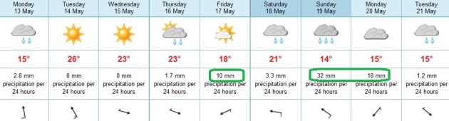
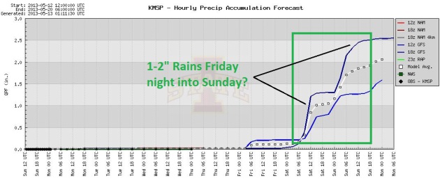
A Wet Pattern. Minnesota's drought should continue
to ease in the coming weeks; some good news for farmers and gardeners
balancing out the unusually late start to spring planting. The ECMWF
(European) model shows the best chance of heavier rains (and embedded
T-storms) Friday, again late Saturday into Sunday.
A Plan B Weekend? We may salvage part of Saturday
(70s with scattered showers and T-storms), but steadier, more widespread
rains are possible Sunday into Monday. A stray T-storm can't be ruled
out later today as a vigorous warm front approaches, but the best chance
of rain comes late week and next weekend.

From
Alerts Broadcaster (issued Sunday):
* Potential for tropical storm or hurricane development impacting the
USA in the next 2 weeks has diminished. Long-range guidance hints at
possible tropical development and very heavy rain for Cancun and
Mexico's Yucatan Peninsula, but the risk has dropped for the Caribbean
and Gulf of Mexico. We're watching it carefuly.
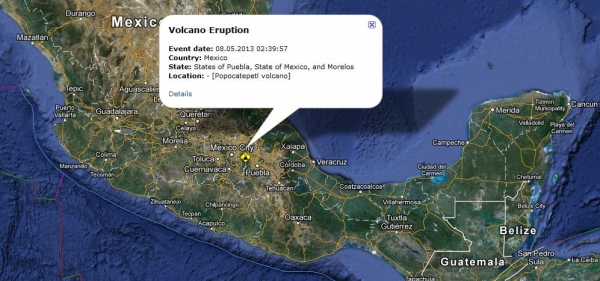
Volcanic Indications Near Mexico City. Mexican
authorities raised the alert level for the Popocatepetl volcano near
Mexico City on Sunday morning after observing an increased level of
explosive activity. The lava dome of Popocatepetl, some 50 miles to the
southeast of the capital, may expand and unleash increasingly powerful
explosions of ash and lava, Mexico's National Center for Disaster
Prevention said in a statement. The alert level for the towering
volcano was raised to yellow phase three from yellow phase two, on
orders from the country's Interior Ministry. It is the third-highest
warning on the center's seven-step scale. This change in activity in
the 5,450-meter (17,900-foot) volcano could provoke big explosions
capable of sending incandescent fragments out over considerable
distances, the center added. Source: RSOE EDIS.
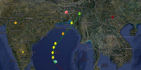
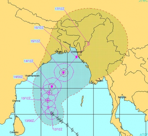
Cyclone Mahasen Aimed At Myanmar, Bangladesh.
Cyclone "Mahasen" is expected to become a Category 2 storm before
weakening as it approaches coastal Myanmar (Rakhine State) and
Bangladesh, with potential landfall late Monday night or Tuesday
morning, local time.
Storm Surge Potential. Although Mahasan is not
forecast to become a major cyclone (hurricane) a 5-8 foot storm surge
may come ashore over coastal Myanmar; closer to 2-5 feet for
Bangladesh, still capable of considerable coastal inundation. The
greatest threat is to tens of thousands of people in Myanmar refugee
camps. Source: Navy Joint Typhoon Warning Center.
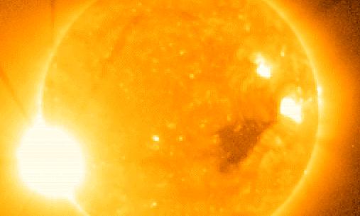
Solar Cycle Peaks Later This Year - Are You Prepared for Possible Disruptions to Power and Communications?
A potentially disruptive and damaging solar flare is reported on Earth
roughly once a decade. The Earth's rotation around the sun will place
it in a more vulnerable position later in 2013, directly exposed to the
most active portion of the sun and sunspots capable of sparking major
solar flares, including potentially damaging X-Flares, which can
disrupt communications, GPS signals, even the power grid. NASA has a
good overview (
"A Super Solar Flare")
detailing the last time the USA experienced a devastating X-Flare, the
"Carrington Event" in 1859. The odds of a similar event are small, but
not zero, and continuity managers should keep the peaking solar cycle
very much top of mind in the coming months. More details:
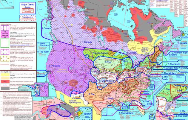
Dialect Map Of U.S. Shows How Americans Speak By Region (Image). This is pretty amazing and worth a closer look; here's an excerpt from
Huffington Post: "...
Aschmann's
research taught him some hilarious and fascinating things. For
example, did you know that in parts of New Jersey, the word "had"
doesn't rhyme with "bad?" (We're not quite sure how that's possible, but
hey, to each his own.) Among Aschmann's other findings:
The map isn't exactly new -- it's been around since at least
2010 -- but Aschmann has been steadily adding to it as people from all
over the U.S. send him audio samples of themselves speaking..."
* A close-up of the USA dialect map and detailed information on the impressive research that went into this is
here.
* image above: Tucson Urban Gardener.
Climate Stories...
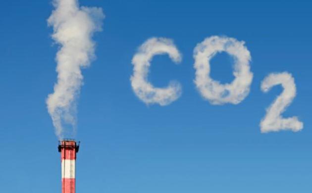
What's In A Number? New Carbon Dioxide Level Unseen In Human History. Here's an excerpt from
ABC News: "...
What
worries scientists in 2013 is not only the amount of CO2 in the
atmosphere, but how fast it continues to build up without showing any
sign of slowing or even stabilizing. Today's rate of carbon dioxide
increase is more than 100 times faster than the increase that occurred
when the last ice age ended, NOAA said today. At this rate, even 400
ppm will soon vanish in the rearview mirror. Unless emissions are
slowed, scientists tell us that babies being born today will enter
their thirties as the CO2 level reaches 450 ppm..." (Image credit
here).
Climate Sensitivity Stunner: Last Time CO2 Levels Hit 400 Parts Per Million The Arctic Was 14F Warmer. Here's an excerpt from
Think Progress: "...
At
the same time, a major new Science study of paleoclimate temperatures —
based on ”the longest sediment core ever collected on land in the
Arctic” – revealed what happened the last time we had similar CO2 levels:
“One of our major findings is that the Arctic was very warm in
the Pliocene [~ 5.3 to 2.6 million years ago] when others have
suggested atmospheric CO2 was very much like levels we see today. This
could tell us where we are going in the near future. In other words, the Earth system response to small changes in carbon dioxide is bigger than suggested by earlier models,” the authors state.
....How sensitive is the climate to increases in CO2, according to this “absolutely new knowledge” of paleoclimate temperatures?
Another significant finding to emerge from this first
continuous, high-resolution record of the Middle Pliocene is
documentation of sustained warmth with summer temperatures of about 59
to 61 degrees F [15 to 16 degrees C], about 8 degrees C [14 F] warmer
than today..."
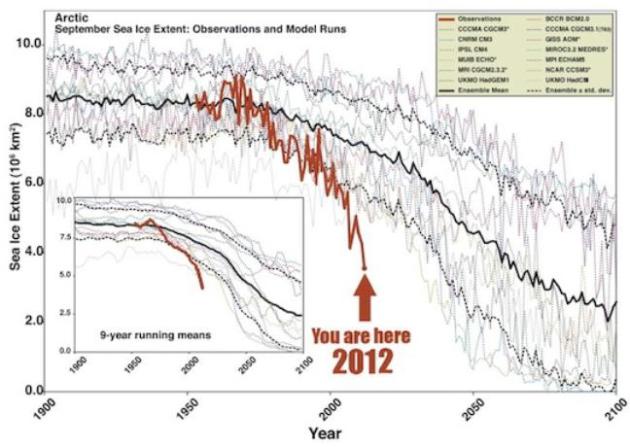
Graphic credit above: "
Arctic sea ice is melting much,
much faster than even the best climate models had projected (actual
observations in red). The reason is most likely unmodeled amplifying
feedbacks. The image (from Climate Crocks via Arctic Sea Ice Blog) comes from a 2007 GRL research paper by Stroeve et al."
Terrible News About Carbon And Climate Change. Let's
hope the markets respond (when a price is finally put on carbon
pollution, like any other form of pollution). Then wait for the climate
change-equivalent of Apple, Google or Tesla. Here's an excerpt of a post
at
The New Yorker: "...
We’ve failed collectively. As Ryan Lizza explained
in miserable detail in 2010, the United States government couldn’t
pass a tepid, eviscerated law. Activists have failed. We’ve all failed
morally: a problem created by the world’s rich will now crush the
world’s poor. In a grand sense it’s also a failure of the creators, and
deniers, of climate change: the Exxon-Mobils, say, or the Wall Street
Journal editorial page.
A victory isn’t worth much if your children and grandchildren will one
day think of you with anger and shame. How do we get out of this mess?
The political system seems hopeless. Yes, government regulation has
done much to relieve us of acid rain and smog. But global warming
combines two intractable problems. Reducing emissions mainly benefits
people who aren’t born and don’t vote. And it requires international
coördination, which is hopeless, and international law, which is
toothless. We should do things like build more public transportation,
which helps people here and now. We should design our cities for a
future with terrible weather. But solving the problem of climate change
through the U.N. is like a small man with olive oil on his hands
trying to pull a whale from the water...."
The True Cost Of Climate Change? Here's a look at
home changing climate and weather patterns (and availability of fresh
water) may impact species and biodiversity, from
Birdwatch: "
Accelerating
world climate change will radically decrease two thirds of common
plants and half the animals, says new research from the University of
East Anglia (UEA). Research published today in the journal Nature
Climate Change look at 50,000 globally widespread and common species,
and found that two thirds of the plants and half of the animals will
lose more than half of their climatic range by 2080, if nothing is done
to reduce the amount of global warming and slow it down. This means
that geographical ranges of common plants and animals will shrink
globally, and biodiversity will decline almost everywhere. Almost two
thirds of common plants and half the animals could see a dramatic
decline this century due to climate change..."
China "Moving To Lead On Climate Change", Says
Report. Wait, this is the same country that's been launching roughly one
new coal-fired power plant every week; a country where, at times, you
can't breathe the air, drink the water or eat the food? The Chinese
realize they have a serious environmental problem, and renewable energy
provides the only way out. Here's an excerpt from
Climate Central: "...
The
report says China and the U.S., the world’s two largest economies
which together produce about 37 percent of world emissions, are both on
track to meet their international commitments on climate change,
something they said in this month’s “historic agreement” they would
tackle together. “Today the energy giants are undoubtedly on the move,
which will fuel global momentum.” China earns praise for several
reasons. It is reducing its emissions growth, and in 2012 cut the
carbon intensity of its economy more than expected. After years of
strong growth in coal use, the rate of growth has declined
substantially. It is also “the world’s renewable energy powerhouse.”
Professor Flannery says: “China has halved its growth in electricity
demand… [and] is quickly moving to the top of the leader board on
climate change...”
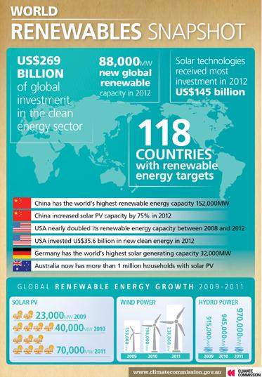
Graphic credit above: "
Global progress on renewable energy graphic." Credit: Climate Commission.