A Real Winter
15
inches of snow on the ground. No grumpy e-mails from snow lovers this
winter, for a change. So far MSP has picked up nearly 40 inches of
powder; 5 inches more than average, to date - and almost 17 inches more
than last winter as of February 4. And just about all of it came from a
cold conga-line of clippers. Each new reinforcing blast of Canadian
chill was preceded by a few inches of fluff.
It adds up, especially when steering winds direct from the Arctic Circle prevent any extended thaws.
If
anyone asks (doubtful) we just topped 5,000 heating degree days since
July 1, 2013. That means we've spent about 7.5 percent more heating our
homes & businesses than during an average winter. Whatever "average"
is.
While a parade of shovel-worthy storms pass south - Minnesota
enjoys cold and quiet weather into next week; 5 more subzero lows
between Thursday & Monday, followed by a thaw the middle of next
week.
At some point a higher sun angle will start to make a dent
in this stubborn, nagging whirlpool of cold air, what's left of the
much-maligned Polar Vortex.<p>Right now I see an extended spell of
30s, even a few 40s the 3rd week of February.
Yes, I'm ready for the Spring Vortex.
Storm Track Gets A Rude Southward Shove.
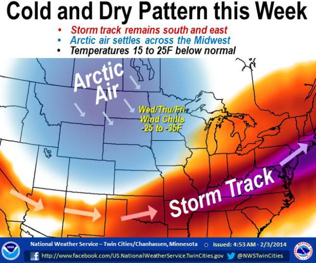
As much as the cold weather is annoying (and it is) it's saving us from
heavy-duty shoveling and even more painful commutes. When it's this
cold it usually means the core of the storm track is too far south/east
of Minnesota for significant snowfalls. That will be the case into at
least the middle of next week. Map: Twin Cities National Weather
Service.
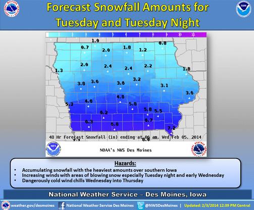
Close Call.
The Des Moines office of the National Weather Service has printed out
expected snowfall amounts across Iowa, as much as 4-6" for metro Des
Moines, with heavier amounts closer to the Missouri border.
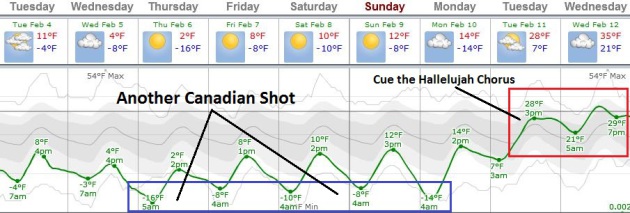
One More Cold Week - Then Improvement.
I can't promise blooming crocus or chirping robins anytime soon, but
data suggests we'll pull out of the worst of the Deep Freeze by the
third week of February. 30s will feel like sweet relief by the middle of
next week. ECMWF (European) guidance: Weatherspark.
Coastal Storm Potential Early Next Week?
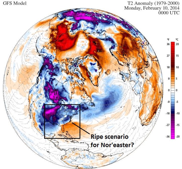
It's still early (it always is), but many of the ingredients may
converge for a significant coastal storm, even a full-fledged Nor'easter
next Sunday and Monday, as the latest surge of Canadian air approaches
the East Coast. Image above: Climate Reanalyzer.
2014: A Tale Of Meteorological Haves And Have-Nots.
The drought continues to deepen in California, while snowfall amounts
are trending well above average for many cities in the central and
eastern USA. Today's
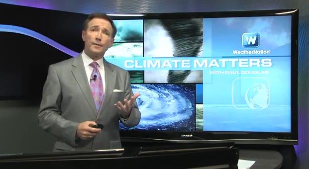
Climate Matters looks at the extremes setting up, speculating on what the big weather story in 2014 may be: "
WeatherNationTV
Chief Meteorologist Paul Douglas looks at the "conga line of storms"
that keep moving across the United States, one right after another. A
number of these systems have brought much above average snowfall to
Philadelphia and parts of the Northeast and Mid-Atlantic states. While
the East is wetter than average, the West finally saw rain after a
record setting 52 days without a drop in Sacramento. Will there be a
break in the pattern? Or will the drought end up being the biggest
weather story of 2014?"

Time Is Running Out For California Drought Relief.
Considering the wet season on the west coast spills over into early
March we still have a few weeks to make up for what some are calling the
worst drought since 1977, possibly longer. Here's an excerpt of a
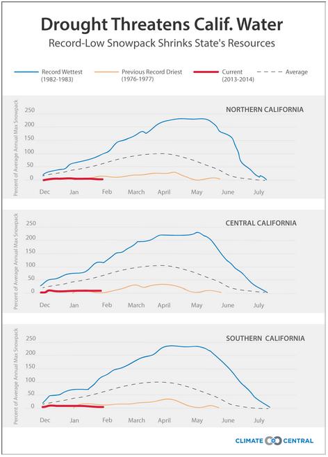
Climate Central post from meteorologist Andrew Freedman: "
The
California drought, now reaching into its 13th month, grows more
devastating with each passing day and there is no sign of significant
relief in sight. More than halfway through the state's wet season and
the Sierra Nevada snowcap
all but non-existent, California's prospects for making up its
precipitation deficit are slim. The snowcap will yield precious little
water and the state would need to get an average of about a foot or more
of rain in the next two months to make up the difference. Forecasts are
not offering much hope of that..."
Graphic credit above: "Comparison
of the water content in California's mountain snowpack so far this
year, compared to the state's wettest and driest years." (The data is divided by region.) Climate Central using CDWR data.
A Drier California Than Ever? Pretty Much.
The Los Angeles Times has the article - here's the introduction: "
The
last 12 months have been the driest on record in California, and this,
on the heels of two below-normal years, prompted Gov. Jerry Brown
to declare that the state is in a drought emergency. Ours is a state
that relies heavily on the winter storms that bring us the vast majority
of our water supply, and those storms have been blocked and diverted so
we have received virtually no significant water in more than a year.
The 2014 water year, which began Oct. 1, is on track to be even drier
than the devastating drought of 1976-77..."
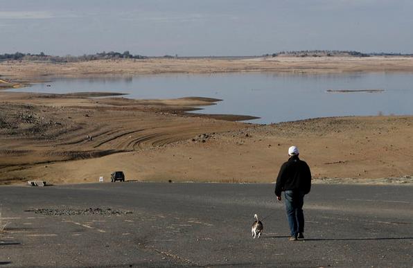
Photo credit above: "
The 2014 water year, which began Oct. 1, is on track to be even drier than the devastating drought of 1976-77."
(Rich Pedroncelli / Associated Press / January 31, 2014).
California Farmers Brace For Drought, Unemployment.
We've quickly gone from inconvenience to crisis mode with California's
drought - at this rate 2014 is going to be long, potentially historic
year, and I don't even want to think about the wildfire season to come.
Here's a clip from AP and
ABC News: "
Amid
California's driest year on record, the nation's leading agricultural
region is locked in drought and bracing for unemployment to soar,
sending farm workers to food lines in a place famous for its abundance.
One-third of the Central Valley's jobs are related to farming. Strains
on water supplies are expected to force farmers to leave fields
unplanted, creating a ripple effect on food processing plant workers,
truck drivers and those who sell fertilizer, irrigation equipment and
tractors..."
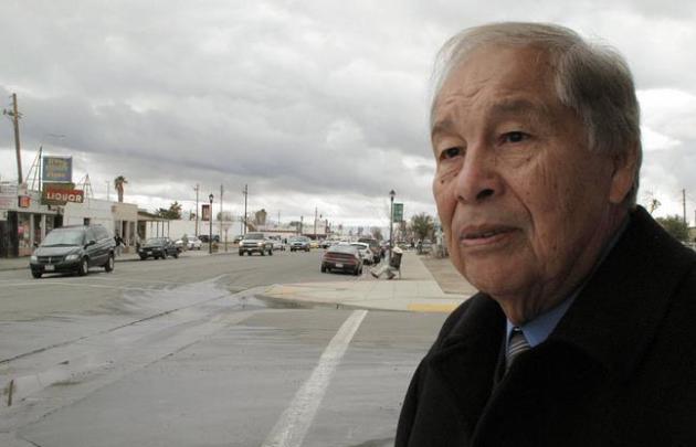
Photo credit above: "In
this Thursday Jan. 30, 2014 photo, Mendota, Calif. Mayor Robert Silva,
72, explains how the state’s drought is sure to drive up unemployment in
his rural farming town during an interview in Mendota. Five years ago,
the last dry year and height of the national recession, farm workers
lined up for free food as unemployment exceeding 40 percent in Mendota.
Silva fears that this year the food lines will be even longer." (AP Photo/Scott Smith).
Alerts Broadcaster Briefing: Excerpt of a
briefing issued Monday morning, February 3, 2014.
*
America's Snow Machine revs into high gear again this week with 2
distinct storms, one already impacting the Mid Atlantic, Northeast and
coastal New England; a second storm pushes across the Central Plains
into the Midwest and Ohio Valley Tuesday into Wednesday.
* Second
surge of snow spreads across Plains into Midwest today into Wednesday;
Chicago forecast to pick up 2-4" with heaviest snow bands probably
passing south of Windy City; greater potential for 6"+ amounts Kansas
City to Peoria to Indianapolis, Toledo, Detroit and Cleveland.
Latest Watches & Warnings.
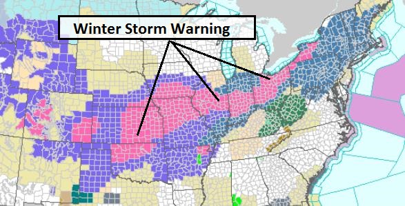
NOAA has issued Winter Storm Warnings from West Virginia, northern
Maryland and southern Pennsylvania into the metro New York City area for
today. Additional warnings have been posted from northwest Oklahoma and
eastern Kansas into metro Kansas City Tuesday and Wednesday as the
second storm gets going.
Storm Overview.
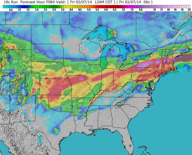
Today's storm puts down a heavy stripe of sloppy, wet snow from
Altoona, York and Lancaster into New York City. The second swath of
heavy snow (heaviest amounts in red and purple) sets up Tuesday PM into
Wednesday as a second storm takes a more northerly track.
Projected Amounts.
About 3-6" of slush will pile up in the New York City area by the time
the storm winds down mid-afternoon today, with 2-4" for Boston, heavier
amounts just inland. The second storm forecast to spin up Tuesday and
Wednesday may dump a foot of snow on eastern Kansas, southeast Nebraska,
northern Missouri into central Illinois. Although Chicago will miss the
heaviest snow bands, Indianapolis may pick up 6" or more of snow, along
with Terre Haute, South Bend, Toledo, Detroit and Cleveland.
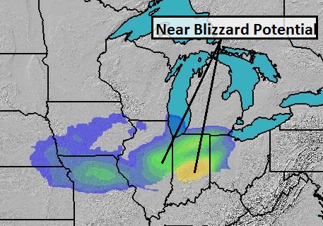
BPI: 9 PM Tuesday.
A burst of heavy snow and strong wind may create near-blizzard
conditions from Champaign-Urbana to Indianapolis late Tuesday, capable
of widespread travel delays (land and air). Right now it appears the
worst conditions will pass just south of Chicago Tuesday PM hours, but
it will be a close call, and travel into and out of O'Hare and Midway
will be impacted by a domino effect of air delays.
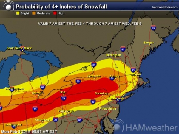
4"+ Snowfall Potential Tuesday - Wednesday.
The second storm pushes significant snow farther north tomorrow and
Wednesday, impacting Indianapolis, Toledo, Cleveland, Williamsport,
Elmira and Albany. The atmosphere should be warm enough for (mostly)
rain Wednesday from D.C. and Philadelphia to New York City.
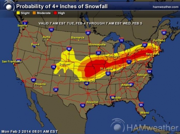
Probability of 4"+ Snows Tuesday - Wednesday.
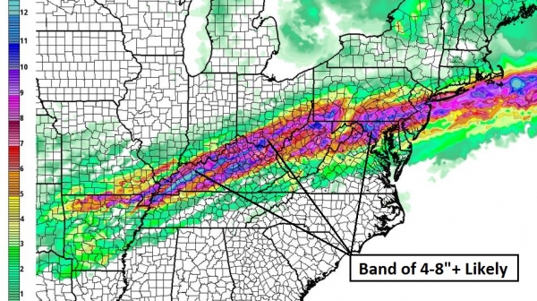
Here's a broader view of the second storm, and which metro areas stand
the greatest chance of seeing a plowable, 4"+ accumulation. Lincoln may
pick up 3-4", with the heaviest amounts from St. Joseph and Kansas City
to near Des Moines, Burlington and Bloomington (IL), pushing toward
Indianapolis and South Bend, reaching Toledo, Cleveland, Erie and
Buffalo Tuesday night into Wednesday.
Weekend Preview and Summary:
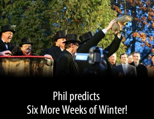
The groundhog's prediction of 6 more weeks of winter sounds about
right, gazing at the maps and model predictions. No quick spring this
year. Travel conditions improve dramatically Thursday and Friday, before
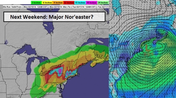
another rain/snow event impacts the East Coast Saturday and Sunday (map
above shows one early solution of next weekend's potential storm,
hinting at a major Nor'easter with strong coastal winds and very heavy
snows over interior New England). It's early to go into details, but
realize that the upcoming weekend may be filled with more unwelcome
weather drama across much of the Northeast, with the best chance of
wind/snow/rain/coastal flooding issues next Sunday and Monday.
Long-range
guidance shows a significant thaw east of the Rockies next week. The
next 36-48 hours will bring the most delays/cancellations and overall
weather headaches. Although I won't be referring to spring fever anytime
soon, conditions do improve, nationwide, by next week.
Paul Douglas - Senior Meteorologist - Alerts Broadcaster
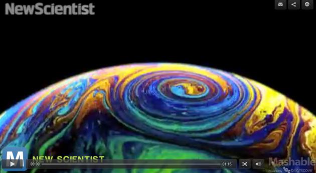
Scientists Think Bubbles May Hold The Key To Understanding Storms (Video). Thanks to my buddy Mike Huang for passing this one along. No, we don't know what we don't know. Here's a clip from
Mashable: "
Bubbles
might be fairly innocuous, but they may also hold a clue to
understanding a more sinister natural phenomena — storms. French
physicists at the University of Bordeaux are studying the behavior of
the soapy substance to more accurately predict the intensity of large storms on the scale of Hurricane Sandy.
The flow of liquid on the bubbles' membranes resembles the movements of
weather systems that travel over the Earth, according to a report in
the Daily Mail..."
China's Deceptively Weak (And Dangerous) Military. Here's an excerpt of an article at
The Diplomat that caught my eye: "...
The
Chinese military is dangerous in another way as well. Recognizing that
it will never be able to compete with the U.S. and its allies using
traditional methods of war fighting, the PLA has turned to
unconventional “asymmetric” first-strike weapons and capabilities to
make up for its lack of conventional firepower, professionalism and
experience. These weapons include more than 1,600 offensive ballistic and cruise missiles, whose very nature is so strategically destabilizing that the U.S. and Russia decided to outlaw them with the INF Treaty some 25 years ago..."
Image credit above: REUTERS/China Daily.
The Sochi Effect.
Talk about over-budget. The 2014 Winter Olympics is an accountant's
worst nightmare. Here's an excerpt from a mind-boggling story at
The New Yorker: "
Whatever
happens on the ice and snow of Sochi in the next couple of weeks, one
thing is certain: this Winter Olympics is the greatest financial
boondoggle in the history of the Games. Back in 2007, Vladimir Putin
said that Russia would spend twelve billion dollars on the Games. The
actual amount is more than fifty billion. (By comparison, Vancouver’s
Games, in 2010, cost seven billion dollars.)..."
The Ultimate Volvo Commercial. 3 million miles - on one vehicle? How is that even possible? Details from
The Truth About Cars.
You Probably Didn't See The Best Super Bowl Commercial. This gives new meaning to OVER THE TOP. Details (and the surreal 2:00 commercial spot) courtesy of
digg.com: "
It's
a shame that this Super Bowl commercial for a personal injury lawyer
named Jamie Casino only aired in Georgia because it was absolutely
insane... and awesome."
"Whoever Is Praying For Snow - Please Stop".
This is from my sister, who lives in Lancaster, Pennsylvania, where
they've picked up as much snow this winter as the Twin Cities.
Master Of The Obvious. No kidding, Phil. Although not officially sanctioned by NOAA, Punxatawney Phil does have his own
web site.
Climate Stories....
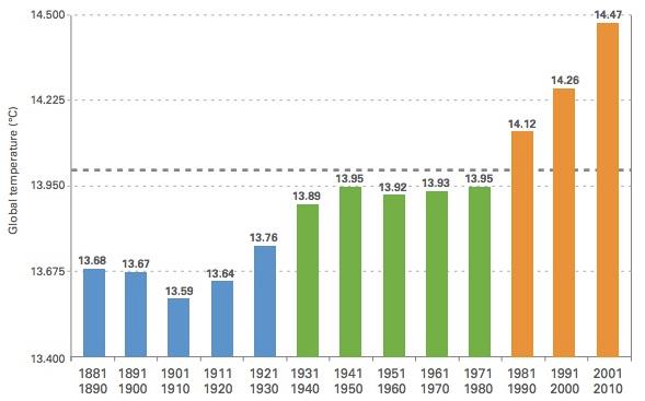
Groundhog Decade: We're Stuck In A Movie Where It's Always The Hottest Decade On Record. Here's the intro to a Joe Romm article at
ThinkProgress: "
Somewhere
on a Hollywood movie set for Groundhog Day, Part 2: Bill Murray wakes
up to find he’s just lived through the hottest decade on record, just as
he did in the 1990s, just as he did in the 1980s. And he keeps waking
up in the hottest decade on record, until he gains the kind of maturity
and wisdom that can only come from doing the same damn thing over and
over and over again with no change in the result. Ah, if only life were
like a movie. Somewhere in PA: Punxsutawney Phil saw the shadow of
unrestricted fossil-fuel pollution from Homo “sapiens” today. That means global warming for another six thousand weeks — and then some (see NOAA: Climate change “largely irreversible for 1000 years”)..."
Earth Talk: Cold Weather Doesn't Mean Global Warming Doesn't Exist.
Keeping a global perspective is difficult (we're all hard-wired to
react to rapid weather changes, not slow changes in climate over time),
but it's critical to keep a broad, global, long-term perspective. Here's
an excerpt from
The Santa Monica Daily Press: "
It's
tempting to think that the cold air and snow outside augur the end of
global warming, but don't rejoice yet. According to the Union of
Concerned Scientists (UCS), weather and climate are two very different
beasts: "Weather is what's happening outside the door right now, today a
snowstorm or a thunderstorm is approaching. Climate, on the other hand,
is the pattern of weather measured over decades..."
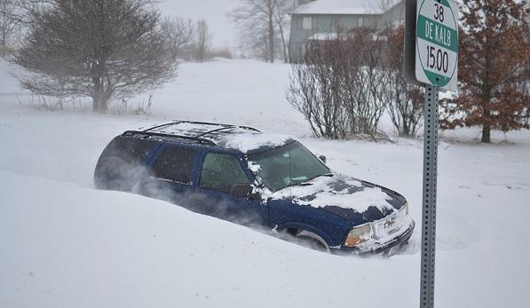
Photo credit above: "
The
harsh winter we are having shouldn’t be viewed as a refutation of
global warming, but rather as further evidence of a growing problem.
Pictured: Trying to get around in Cortland, Ill. on Jan. 4, 2014." (Michael Kappel, courtesy Flickr).
An Imminent Transition To A More Arid Climate In Southwestern North America.
In light of deepening drought across California and the southwestern
USA I stumbled upon this research paper from Richard Seager at the
Lamont-Doherty Earth Observatory of Columbia University. Here are a few take-aways from his research:
- Southwestern
North America and other subtropical regions are going to become
increasingly arid as a consequence of rising greenhouse gases.
- The
transition to a drier climate should already be underway and will
become well established in the coming years to decades, akin to
permanent drought conditions.
- This is a robust result
in climate model projections that has its source in well represented
changes in the atmospheric hydrological cycle related to both rising
humidity in a warmer atmosphere and poleward shifts of atmospheric
circulation features.
Floating
ice (light blue) and grounded ice (dark blue) in lakes of Alaska’s
North Slope near Barrow, as seen by ESA’s ERS-2 satellite in 2011.
Credit: Planetary Visions / University of Waterloo, Canada / ESA
Read more at http://www.redorbit.com/news/science/1113061766/winter-ice-is-on-the-decline-across-alaskan-lakes/#mUUJ2lR8DRBE3TAs.99
According to a new study from the
European Space Agency,
ice in northern Alaska’s lakes during winter months is on the decline.
Twenty years of satellite radar images in the study, which was published
in
The Cryosphere, show how shifts in our climate are affecting high-latitude regions.
[ Watch the video: Monitoring Lake Ice ]
Alterations
in air temperature and winter precipitation over the last 50 years have
affected the timing, interval and density of the ice cover on lakes in
the Arctic, the study said.
Read more at http://www.redorbit.com/news/science/1113061766/winter-ice-is-on-the-decline-across-alaskan-lakes/#mUUJ2lR8DRBE3TAs.99
The Psychology Of Climate Change.
I see a fair amount of denial, but many people understand what's
happening, and a percentage of them are impacted emotionally and
psychologically. It's hard not to look at the trends and not get
depressed, but I tell people the truth: we'll figure out solutions to
adapt and hopefully mitigate carbon pollution. In the end we won't have
much of a choice. Here's an excerpt from Doug Craig's always-excellent
Climate of Change at redding.com: "...
The
article indicates that levels of depression and anxiety will increse as
our climate becomes less stable. "According to a report released by the
National Wildlife Federation's Climate Education Program and the Robert
Wood Johnson Foundation in 2012, climate change-related events are
expected to cause an increase in mental and social disorders. Such
disorders as include depression, anxiety, post-traumatic stress
disorder, substance abuse, suicide and violence. The report is entitled
"The Psychological Effects of Global Warming on the United States: And
Why the U.S. Mental Health Care System is not Adequately Prepared..."
