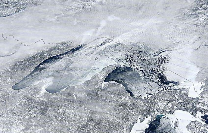
Visible Satellite of Ice on Superior
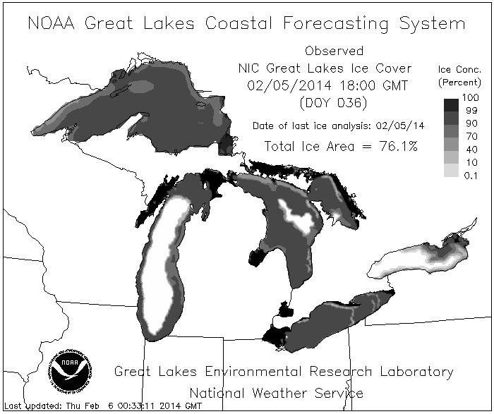
Here's a NOAA visible satellite image of Lake Superior taken on February 3rd. Note the big ice chunks over the central and eastern part of the lake. According to NOAA's Great Lakes Coastal Forecasting System, nearly 90% of Lake Superior is covered in ice!
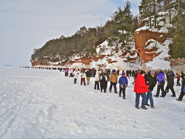
Bayfield Ice Caves Are Quite Popular
With all the ice on Lake Superior, the Bayfield Ice Caves are pretty popular this year! Take a look at this story from Circle Tour Adventures... Apparently, nearly 6000 people visited the Ice Caves last Saturday!
"This photo ran on the front page of the Ashland Daily Press today. To be frank, I’m a bit stunned. The National Park Services estimates that 6,000 people visited the mainland Sea Caves on Saturday alone. In big cities, this number might seem insignificant. But you have to remember that I live in a county with no stoplights and a TOTAL population of 15,000. In other words, this is insane."
See the full story HERE:
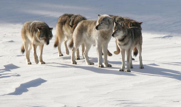
Lake Superior Ice Good For Wolves?
Now this is an interesting story from Isle Royale. Because of the great ice extent over Lake Superior this year, an ice bridge from Canada to the Island may be just enough for different wolves to move onto the island, which could help to add different DNA into the dwindling population that is currently there.
"The brutal cold we’ve experienced this winter might have an upside. Researchers who study the declining population of wolves on Isle Royale National Park in Lake Superior are watching the ice on the lake to see if a bridge will develop between the island and the shore of Ontario. If so — and it’s looking good — they hope it will entice new wolves to walk across the ice to the island and perhaps mate with the current Isle Royale population."
See the full story from LansingStateJournal.com HERE:
What you might now know about Isle Royale is that there is a pretty dynamic preditor-prey relationship between wolves and moose. This relationship has been studied for nearly 5 decades on the island and is considered to be: "The longest continuous study of any predator-prey system in the world."
Read more on the study from IsleRoyaleWolf.org HERE:
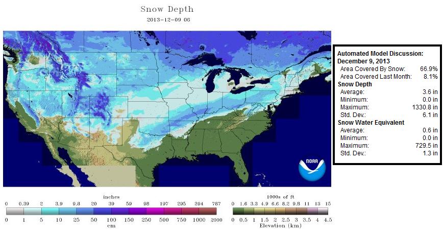
2nd Highest National Snow Coverage This Winter
As of February 6th, NOAA's NOHRSC showed nearly 64% national snow cover, which is the 2nd highest snow cover of the winter season.
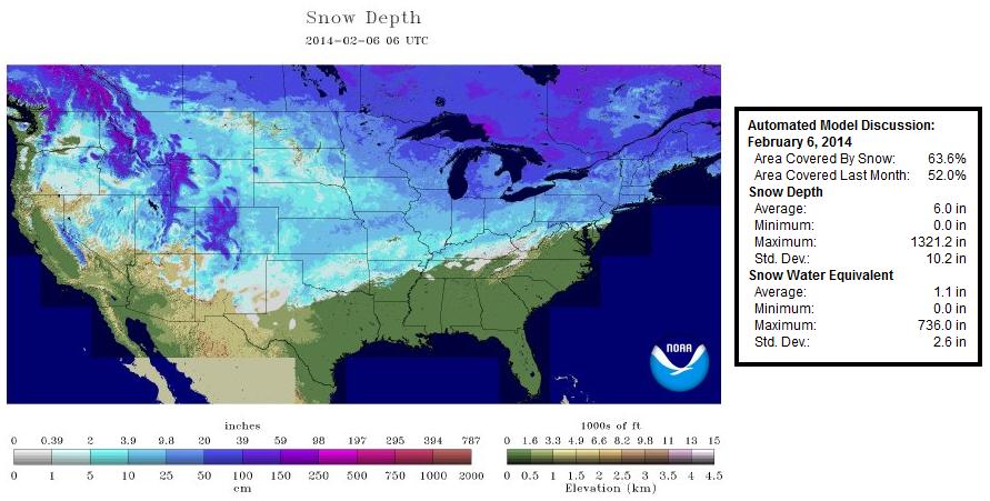
The highest national snow cover of the winter season so far occurred on December 9, 2013 when nearly 67% was covered in snow.
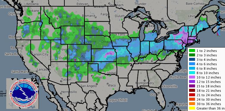
Snowfall Past 72 Hours
It's been a wild ride over the past week. We've seen 4 separate snow systems move across parts of the nation. The most significant one dumped up to 12"+ from the Central Plains to the Northeast Tuesday and Wednesday. The more recent one brought sleet & snow accumulations to parts of the Gulf Coast States on Thursday.
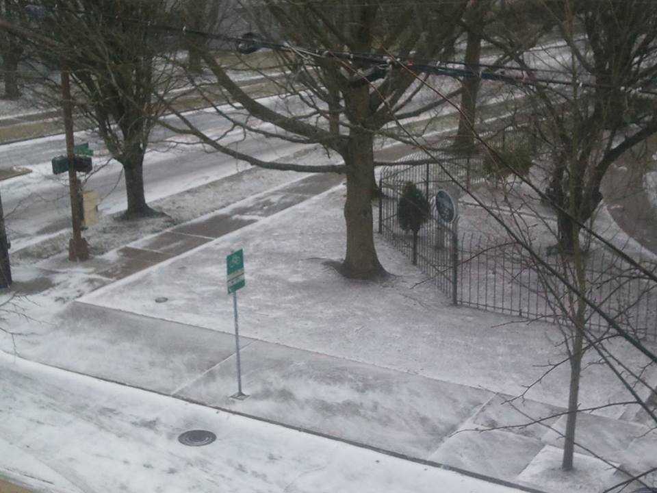
Here was the view from Ft. Worth, TX thanks to @NWS_Southern_US

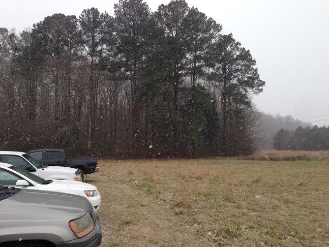
This was the view from Meridian, Mississippi thanks to my good friend Chris Misun who tells me this is the second time he has seen snow in one weeks time.
Major Snow in the Western U.S.
How about this! Snow in Portland, OR from Thursday thanks to Julie Generic who said it was coming down pretty good at the time these pictures were taken.

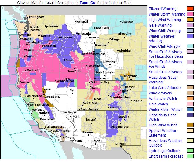
Western Winter Weather Headlines
Take a look at all the colors in the western U.S. - most of these are winter weather headlines where feet of snow can't be ruled out by the end of the weekend for some of the highest elevations.
See more from the NWS Western Region HERE:
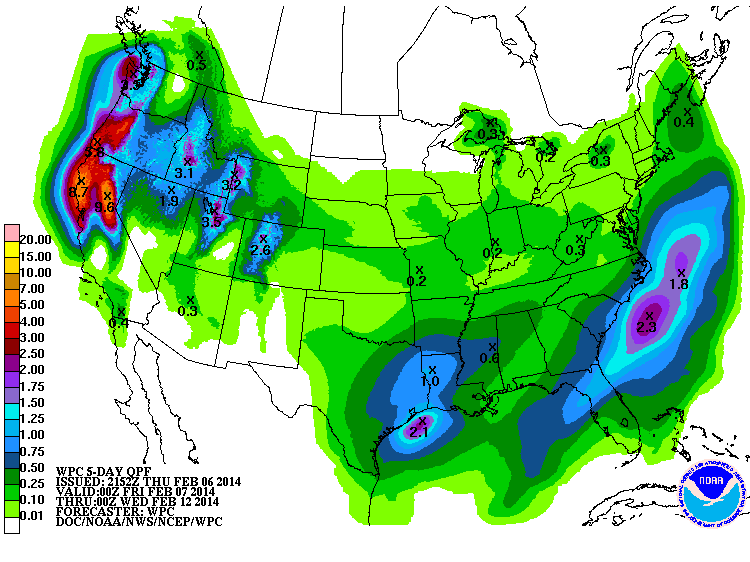
Much Needed Western Precipitation
According to NOAA's HPC 5 day precipitation forecast, there could be 5"+ total precipitation by PM Tuesday.
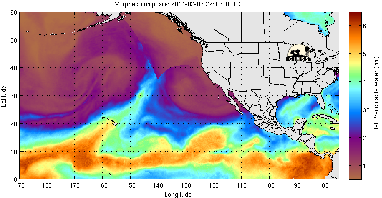
Atmospheric River in the Pacific Returns
Nice to see this return... it the atmospheric river! When this sets up, it tends to bring several inches of precipitation to the West Coast. Note the thin bright finger poking northeast from Hawaii. Another name for this is called the Pineapple Express because this river of moisture tends to extend from Hawaii to the West Coast. It's called the Pineapple Express because pineapples are grown in Hawaii!
What Is an Atmospheric River?
"Atmospheric Rivers (AR) are relatively narrow regions in the atmosphere that are responsible for most of the horizontal transport of water vapor outside of the tropics. While ARs come in many shapes and sizes, those that contain the largest amounts of water vapor, the strongest winds, and stall over watersheds vulnerable to flooding, can create extreme rainfall and floods. These events can disrupt travel, induce mud slides, and cause catastrophic damage to life and property. However, not all ARs cause damage – most are weak, and simply provide beneficial rain or snow that is crucial to water supply."
See more from NOAA's Earth System Research Laboratory HERE:
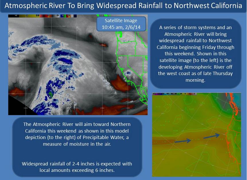
(image courtesy: @NWSEureka)
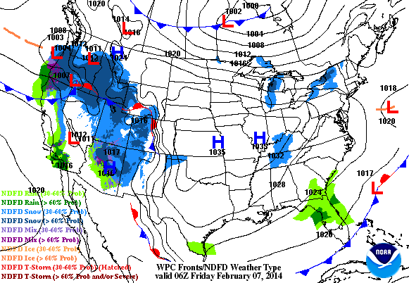
Weekend Storm System in the East?
Watch the end of the loop here and note the blue blob headed toward the Northeast. This system doesn't looks quite as impressive as it did earlier this week, but snow accumulations by late weekend are still in the works. Meanwhile, note the steady stream of significant moisture in the western U.S.!
Our active February continues, stay tuned for further updates. In the meantime have a great rest of your week/weekend ahead!
Twitter: @TNelsonWNTV