On Edge
I'm
exhausted - from banging my head against the wall. In a perfect world,
12 hours before a significant weather event, the weather models would
agree. No discrepancies. Meteorologists are confident; everyone is on
the same page!
Right.
Today's scenario is especially murky.
NOAA's NAM model kept the heaviest snow bands well east of Minnesota
yesterday, but last night's (00z) run finally came in line with guidance
from GFS and ECMWF, both hinting at very significant snowfall amounts
for the Twin Cities. Snow gets heavier as the day goes on, accumulating
at the rate of 1" an hour by afternoon and tonight. By Friday morning
there's a good chance many towns and suburbs within 30-40 miles of MSP
may wake up to 5-10" of new snow.
I suspect this will be the biggest snowfall of the winter, to date. Plan on significant delays and cancellations Friday morning, with travel slowly improving during the day tomorrow.
Blizzard
Warnings are posted just south of the Twin Cities, where high winds
accelerating into a rapidly deepening storm may reach 30-40 mph,
whipping up severe blowing & drifting. But our recent thaw has left
an icy crunch on top of the snow, which may prevent a worst-case
white-out towards Mankato, Northfield & Rochester. Be careful out
there later today and tonight
Next week will feel more like late
January, and any extended thaw in early March appears to be a cruel
hallucination, a meteorological mirage. I see a very (VERY) cold start
to March, with some recovery after March 5.
A gently used echo of
the Polar Vortex is about to pinwheel south the next 2 weeks,
temperatures bottoming out (again) roughly 1 week from now. Not as
extreme as a few weeks ago, but cold enough.
Isn't this fun?
One Tough Travel Day.
After a wet/slushy start, travel conditions gradually deteriorate as
the day goes on, with the worst travel coming from this afternoon into
tonight, when snow may accumulate at the rate of 1" an hour at times. I
expect school closings/delays Friday morning, followed by gradually
improving travel conditions as the day goes on tomorrow. Details on the
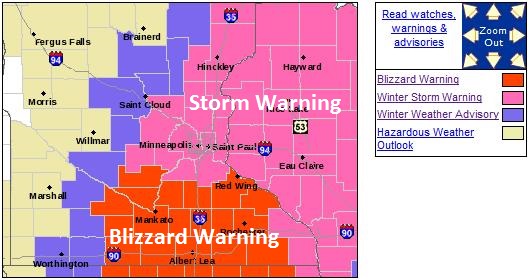
Blizzard Warning:
...SIGNIFICANT WINTER STORM TO AFFECT EASTERN AND SOUTHERN
MINNESOTA AND ALL OF WEST CENTRAL WISCONSIN THURSDAY AND THURSDAY
NIGHT...

A BLIZZARD WARNING IS IN EFFECT FOR ALL OF SOUTH CENTRAL AND
SOUTHEAST MINNESOTA...INCLUDING AREAS SOUTH OF A LINE ROUGHLY
FROM SLEEPY EYE...TO GAYLORD...TO NORTHFIELD...TO RED WING. THIS
INCLUDES INTERSTATE 35 SOUTH OF NEW MARKET... AND THE INTERSTATE
90 CORRIDOR BETWEEN FAIRMONT AND ALBERT LEA.

A WINTER STORM WARNING IS IN EFFECT FOR ALL OF EAST CENTRAL
MINNESOTA AND WEST CENTRAL WISCONSIN...INCLUDING THE ENTIRE
GREATER TWIN CITIES METRO AREA AND ADJACENT LOCATIONS TO THE
IMMEDIATE NORTH AND NORTHWEST OF THE METRO...AND ALL OF WEST
CENTRAL WISCONSIN.

TO THE WEST OF THE WARNING AREAS...A WINTER WEATHER ADVISORY IS
IN EFFECT FOR AREAS FROM SOUTHWEST MINNESOTA INTO CENTRAL
MINNESOTA FROM WALNUT GROVE AND REDWOOD FALLS...NORTH-
NORTHEASTWARD TO OLIVIA...LITCHFIELD... THE GREATER SAINT CLOUD
AREA...AND LITTLE FALLS AND LAKE MILLE LACS.

HEAVY SNOW AND STRONG WINDS WILL RAPIDLY SPREAD NORTHWARD ACROSS
THE ENTIRE AREA THURSDAY MORNING...AND PERSIST THROUGH THURSDAY
NIGHT. STRONG WEST TO NORTHWEST WINDS AND WIDESPREAD SEVERE
BLOWING AND DRIFTING SNOW AND WHITE OUT CONDITIONS WILL
OCCUR...ESPECIALLY ACROSS THE BLIZZARD WARNING AREA.
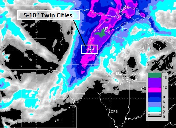
Very Plowable.
Models are finally converging on a similar solution, showing the
heaviest snow band over eastern Minnesota and the northwestern third of
Wisconsin, where some 5-10" amounts are possible, the best chance of a
cool foot from Eau Claire to Hayward and Herbster. Meanwhile St. Cloud
will pick up closer to 2-4" snow, with little or no snow from Windom to
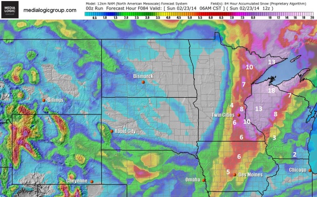
Alexandria to Wadena and Bemidji. NAM snowfall forecast courtesy of NOAA
and Ham Weather.
Biggest Snow Of The Winter?
The models have been flip-flopping back and forth, but now the NAM and
RPM models are both coming in line with GFS and ECMWF, hinting at a
(very) significant snowfall for much of southern and eastern Minnesota,
as much as 10" in some towns. The best chance of a cool foot: western
Wisconsin. 12 km RPM model solution above courtesy of WSI.
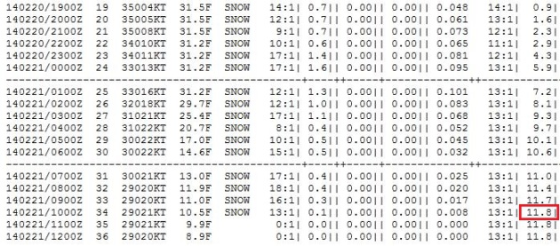
Cobb Method.
We're always trying to compensate (insert bad joke here) for snow
compaction and rain:snow ratios. The Cobb Method is one way to fine-tune
snowfall predictions, and the latest NAM outlook (corrected via Cobb)
shows a whopping 11.8" at MSP by 5 AM Friday morning. Not sure we'll see
quite that much, but feeling more confident we'll wind up in the 5-10"
range.
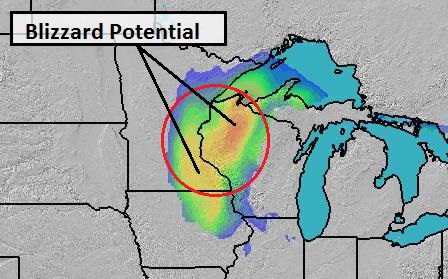
BPI: 9 PM Thursday Evening.
Our internal Blizzard Potential Index shows near-blizzard conditions
from the Twin Cities to Rochester at 9 PM this evening, a better chance
of white-out conditions from Eau Claire to Hayward, Wisconsin. Travel
conditions will get worse as the day goes on, with the worst driving
conditions this evening and tonight. Source: Ham Weather.
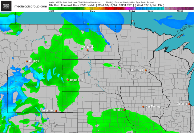
16 Hour Snow Burst.
A light mix is possible this morning, but by midday temperatures aloft
are cold enough for all snow, becoming more powdery as we head into
tonight with temperature dropping thru the 20s. Snow shuts off around 6
AM Friday morning, but I have a hunch many schools will be closed
tomorrow. Just a gut feel. 4 km NAM Future Radar product courtesy of
NOAA and Ham Weather.
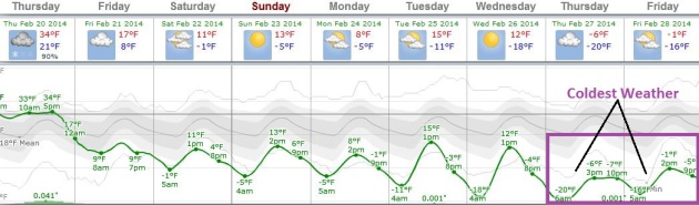
A Fleeting Thaw.
I hope you enjoyed 3 days of highs above 32F, because another Canadian
Smack is brewing; not as cold as a few weeks ago, but a week from now
highs may struggle to reach 0F in the metro with lows dipping to -10F,
even -15F in the suburbs. We've already enjoyed 44 subzero nights so far
this winter. I suspect we'll top 50 subzero nights before the winter is
finally over. Graph: Weatherspark.
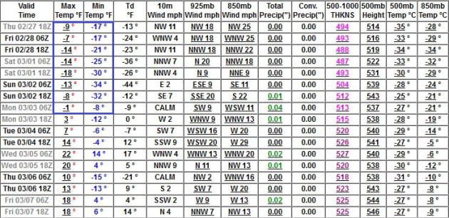
Numbing Late Next Week - Then Slow Recovery.
When I tell you that our weather is STUCK I'm not exaggerating. It's
remarkable how persistent this pattern has been, favoring drought in the
western USA, and unrelenting waves of polar chill east of the Rockies.
GFS data shows temperatures bottoming out late next week, followed by
20s after March 5. A numbing start to March, but it will get better. In
theory.
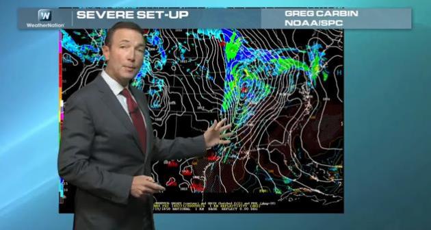
From Blizzards To Tornadoes.
The weather menu has something for everyone today; from blizzard
conditions tonight from Iowa into eastern Minnesota and western
Wisconsin to a few supercell T-storms and tornadoes over the Ohio and
Tennessee Valley, today's weather will not be for the faint of heart.
Here's a recap of today's edition of
Climate Matters: "
WeathernationTV
Chief Meteorologist Paul Douglas looks over the coming severe weather
outbreak for Thursday. As well as some storms on the Earth's surface, we
show the results of a storm from the Sun! The aurora was active on
Wednesday morning and we have viewer photos! On the severe side of
things, what part does melting snow and frozen ground play into it all?
When and what kind of weather can we expect with this system?"
Alerts Broadcaster Briefing: Wednesday afternoon, February 19, 2014.
*
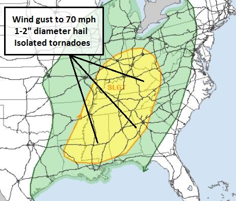
Severe thunderstorm outbreak still expected Thursday PM hours from the
Ohio Valley into the Mid South. A few isolated tornadoes are possible,
but the main risk is straight-line wind gusts to 70 mph and 1-2"
diameter hail.
* Rapid snow melt coupled with rain increases the
risk of urban, stream and river flooding, especially Indianapolis and
South Bend to Toledo and Cleveland by late week.
* Slight severe
risk for eastern USA Friday; strong to severe T-storms possible as far
north as New Jersey. Some straight-line wind damage possible Carolinas
to Georgia; tornado risk drops.
* Blizzard Warnings in effect for
much of Iowa and southern Minnesota. Potential for significant snow,
coupled with high winds and blowing/drifting late Thursday and Thursday
night across the Upper Midwest.
Thursday Severe Storm Risk.
SPC still has a "slight risk" of severe storms, implying an outbreak
Thursday PM hours. Most areas will experience gusty winds and 1-2"
diameter hail. A few tornadoes are possible, probably EF-0 or EF-1, best
chance from near Evansville south to Nashville and Huntsville late
afternoon hours tomorrow. The first severe outbreak of the season always
attracts attention, but right now I don't expect a widespread outbreak
of violent, long-track, long-lasting tornadoes. Source: NOAA SPC.
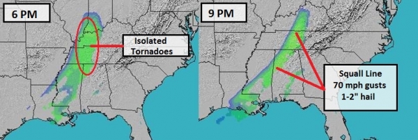
Thursday TPI.
Our in-house Tornado Potential Index shows an enhanced risk of (mostly
small/brief) tornadoes by late afternoon Thursday from near Evansville
and Bowling Green to Memphis and Nashville. A few supercell
thunderstorms capable of damaging hail and tornadoes are possible during
the late afternoon hours, especially Tennessee River Valley. Any
supercells congeal into more of a solid squall line by evening, with
60-70 mph wind gusts and 1-2" diameter hail the main concern from
Louisville to Knoxville to Huntsville. Strong storms reach Atlanta later
Thursday night, capable of pea-size hail. Source: Ham Weather.
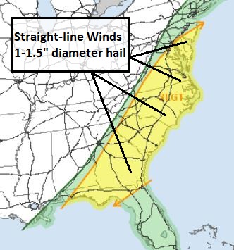
Friday Severe Risk.
The leading edge of colder air, coupled with lingering instability and
low-level moisture (dew points in the 60s) may spark more strong to
severe storms Friday from Cape May and Washington D.C. to Richmond,
Norfolk, Charlotte, Columbia and Atlanta - many of the same cities
impacted by heavy snow and ice less than 1 week ago. Serious
weather-whiplash. I expect any line of severe storms to be weaker than
tomorrow, but still capable of (minor/moderate) wind damage Friday.
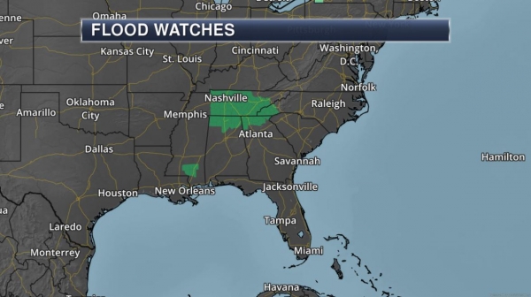
Potential For River Flooding.
The combination of rapidly melting snow, frost lingering in the ground
and expected rain may push a few streams and rivers out of their banks
later this week across the Ohio Valley. The greatest potential for
flooding runs from Champaign-Urbana to Indianapolis, Toledo and
Cleveland. Some urban flooding of low-lying and poor drainage areas may
also result in this zone. Be alert for flooded roads and bridges
tomorrow into Saturday. Source: NOAA.
Summary:
We're watching a variety of weather threats, including severe storms,
damaging winds and a risk of isolated tornadoes Thursday afternoon and
evening from the Ohio River southward to Nashville and Huntsville. Rapid
melting coupled with a squall line of heavy rain may result in urban
and river flooding from Indianapolis to Cleveland Thursday and Friday,
when a line of severe thunderstorms pushes across the East Coast. Deep
into the cold air blizzard conditions may impact travel from Iowa into
eastern Minnesota and western Wisconsin late tomorrow into Friday
morning.
The transitions form winter to spring always leaves Mother Nature in a foul mood. Today is Exhibit A.
Paul Douglas - Senior Meteorologist - Alerts Broadcaster
Fire Season Underway In Arizona, New Mexico.
Stating the obvious, it's a little early to be tracking wildfires,
considering this is still the (alleged) wet season for California and
the southwestern USA. Here's an excerpt from AP and
The Denver Post: "
Recent
warm weather, dry conditions and a spate of brush fires on the
outskirts of major cities in Arizona and New Mexico are prompting
warnings that the 2014 wildfire season is already underway.
In the Albuquerque area, Lt. Michael Everett of the Bernalillo County
Fire Department said fire conditions are already dangerous because
there's been little rain or snow. "It is starting early, and everybody
needs to be aware, just be very careful," Everett said..."
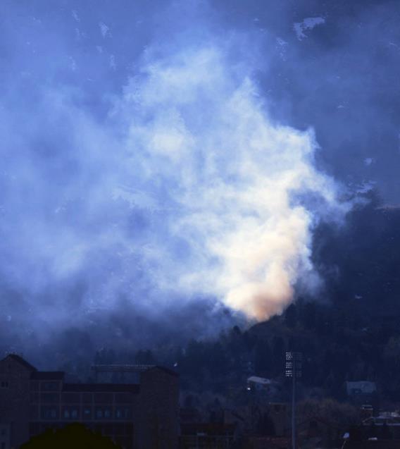
Photo credit above: "Smoke
ruses from a grass fire on Flagstaff Mountain in western Boulder, Colo.
on Tuesday Feb. 18, 2014. City officials say the fire, which has been
contained, started Tuesday afternoon on private property." (AP Photo/The Daily Camera, Paul Aiken).
Why Taxpayers Will Bail Out The Rich When The Next Storm Hits. Here's an excerpt of an investigative report from
NBC News that made me do a double-take: "
As
homeowners around the nation protest skyrocketing premiums for federal
flood insurance, the Federal Emergency Management Agency has quietly
moved the lines on its flood maps to benefit hundreds of oceanfront
condo buildings and million-dollar homes, according to an analysis of
federal records by NBC News. The changes shift the financial burden for
the next destructive hurricane, tsunami or tropical storm onto the
neighbors of these wealthy beach-dwellers — and ultimately onto all
American taxpayers..."
Climate Stories....
Vision Prize: Scientists Are Worried The IPCC Is Underestimating Sea Level Rise. Here's a snippet of a story running at
The Guardian: "...
The Vision Prize results
revealed that despite the much higher sea level rise estimates this
time around, the survey participants are worried that the IPCC is still
underestimating future sea level rise. 41 percent responded that it's
likely or very likely that sea level rise will exceed the IPCC highest
estimate, and 71 percent answering that it's at least as likely as not.
Conversely, only 5 percent responded that it's likely sea level rise
will be less than the IPCC lowest estimate, and 83 percent called this
scenario unlikely..."
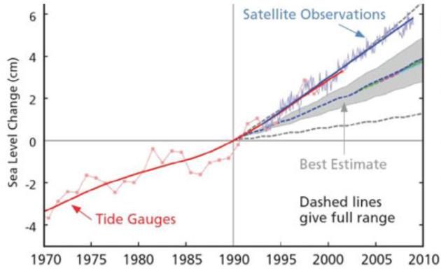
Graphic credit above: "
Graph
by Stefan Rahmstorf comparing measured sea level rise (red and blue) to
previous IPCC estimates (grey and dashed lines), showing sea level rise
is happening faster than expected."
How Big Oil Gave Up On The Climate.
The great irony, one of many, is that a rapidly shrinking summer ice
cap in the Arctic is making it easier for oil companies to explore and
drill for more oil, which will eventually be burned, with a subsequent
release of CO2 into the atmosphere, a process at least partially
responsible for disappearing summer ice up north.
Slate has the story - here's a clip: "...
For
true believers in the free market, Funk points out, there are two
possible responses to climate change. The first is to deny it. This is
becoming ever more awkward, however, as the evidence piles up. The
second response is to profit from it. The free market, these new
libertarians argue, will provide the perfect incentive for
forward-thinking businesses to find new ways to adapt to a hotter and
more turbulent world. So while the politicians are arguing over whether
climate change is real, a growing number of businesses are betting hard
that it is—and getting rich as they’re proved right..."
Photo credit above: "
Shell calls for action on climate change while exploring the Arctic for oil." Photo courtesy TJ Guiton/Creative Commons.
Billionaire Climate Change Activist Tom Steyer Plans $100 Million Ad Push In 2014. Details from
Huffington Post; here's an excerpt: "
Billionaire
retired investor Tom Steyer is planning a $100 million push to make
climate change a key issue in the 2014 midterm elections, the New York Times reports. According to the Times,
Steyer wants to make his group, NextGen Climate Action, a critical
player in this year's races by putting $50 million of his own funds into
the San Francisco-based group and seeking an additional $50 million
from outside donors. The former hedge fund manager reportedly met with
two dozen liberal donors earlier this month to offer details on his plan..."
5 Reasons Why Climate Change Is Back In The News. CNN has the story - here's a clip: "...
After
what seemed like a lull in political focus on the issue, why is
everyone talking about it this week? A convergence of events and factors
-- blizzards in the East and drought out West, an administration acting
on oft-stated intentions, the pending Keystone pipeline decision --
have renewed debate on a topic that alternately captures attention or
numbs the public..."
Utah Lawmaker: Our Atmosphere Needs More Carbon Dioxide. Yes, and my hamburger needs more arsenic and carcinogens.
The Salt Lake Tribune has the head-shaking story; here's an excerpt: "
Arguing
that we need more carbon dioxide, not less, in the atmosphere, Rep.
Jerry Anderson, R-Price, has proposed legislation that would limit the
state’s ability to regulate emissions of the greenhouse gas. HB229
narrows the definition of the term "air contaminants," clarifying that
"natural components of the atmosphere," including nitrogen, oxygen and
other stable, or noble gases, are not pollution..."

China Beats U.S. On Smart-Grid Spending For First Time.
Bloomberg Businessweek has the article - here's an excerpt: "...
Smart
grids allow power generators and users to monitor usage, helping
utilities adjust supply to demand and reducing costs by saving energy in
transmission. China has installed almost 250 million smart meters,
which enable customers to provide immediate feedback to utilities that
are able to use the data to set pricing and smooth fluctuations in
consumption..."