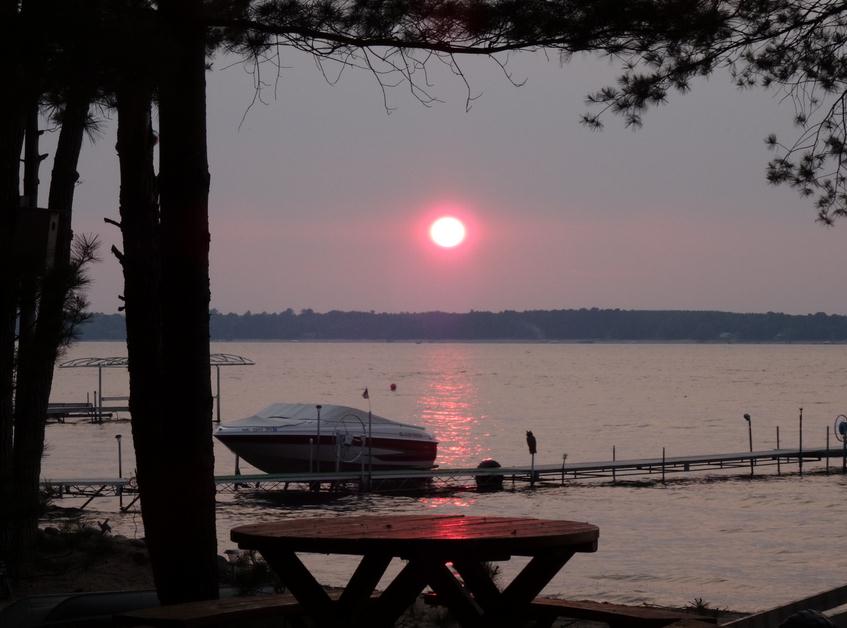
Crop Stress
People, pets & livestock certainly feel the
heat. So do corn and beans. Minnesota's crops are under increasing
stress, statewide. August rains have been spotty and fickle, heaviest
over northern counties.
"Have you seen the corn crop lately?" Rob Koch
asked me yesterday. He's one of a dozen on-air meteorologists I work
with, specializing in ag weather. "Everything is drying up rapidly -
this will impact yields" he said.
The Twin Cities metro picked up nearly 2 inches
of rain August 5-6 from severe storms. But much of that water fell in a
torrent, running off into streets & streams, not soaking into
topsoil. Since then it's been bone-dry across much of central/southern
Minnesota; little or no rain in 3 weeks.
I don't expect another historic drought, but moderate drought may creep back into southern farms shortly. Let it rain.
Expect slight relief today, a few T-storms
Thursday - warming into the low 90s Friday & Saturday before a
dramatic shift in the pattern. A strong cool front sweeps blast-furnace
heat & humidity out of Minnesota on Sunday as temperatures hold in
the 80s. 70-degree highs Labor Day, 40s up north early?
A/C to sweatshirts in the span of 36 hours this upcoming weekend.
More whiplash.
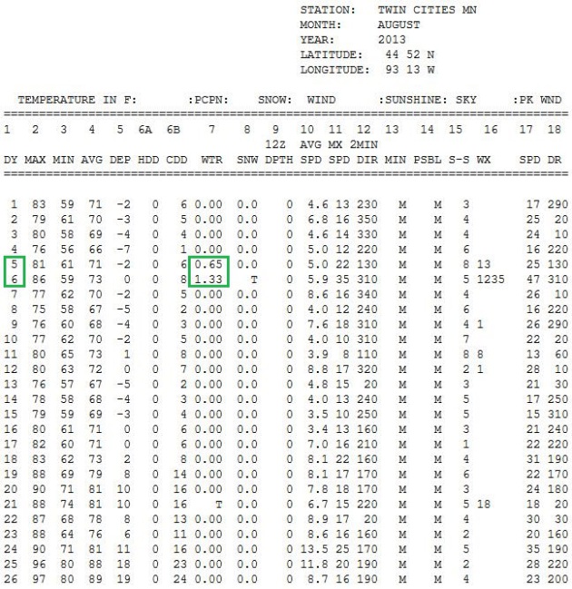
Sparse August Rains. Rainfall data, courtesy of
NOAA,
shows the state of our increasingly dry August. Nearly 2" of rain fell
August 5-6, since then it's been dry with only a TRACE of rain in the
Twin Cities metro. That's why crops are stressed. Farmers were hoping
for heat AND rain. We only got the heat.
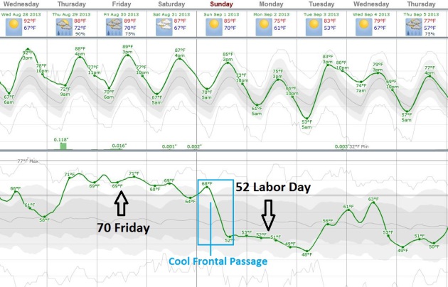
The End Is Near. To the heat wave. Sticky 70-degree
dew points linger into early Sunday, and then a vigorous cool frontal
passage pumps Canadian air into Minnesota. By Labor Day dew points reach
50-52F, meaning half as much water in the air. Highs next week: 70s to
low 80s, much closer to average. ECMWF temperature and dew point trends
courtesy of Weatherspark.
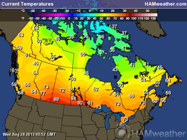
Canada Is Catching A Cold. After record warmth over
much of northern and western Canada much of July and early August the
lower sun angle is finally catching up with air temperatures. Tuesday
evening temperatures were in the 50s and 60s over much of Canada, some
20s and 30s showing up near the Arctic Circle. For the latest
temperature
click here; data courtesy of Ham Weather.
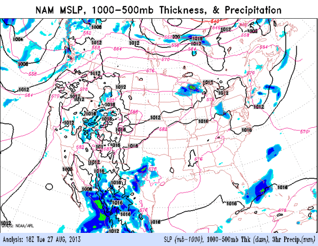
Heat Bubble Breaks Down By Labor Day. The nearly
stationary heat-pump high pressure ridge anchored over Missouri shows
signs of finally breaking down early next week. The best chance of
T-storms comes Thursday, another (smaller) chance of a little rain late
Saturday as Canadian air pushes south of the border. NAM model: NOAA.
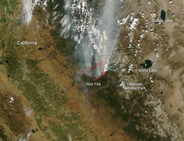
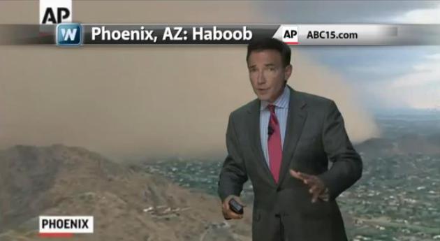 The Wild, Wild West
.
The contrasts out west are remarkable, a sharp dividing line separating
drought from flood. Throw in a few Los Angeles-size wildfires and an
occasional haboob and you have all the meteorological bases covered. In
today's edition of
Climate Matters
I examine the extreme contrats, and how smoke from the Rim Blaze at
Yosemite is showing up as far north as Minnesota (and Canada).
Rim Fire Update. Here's a good explanation (and additional links for current information) from
NASA: "
The
Rim Fire in northeastern California continues to burn on the
Stanislaus National Forest, Yosemite National Park, and the Bureau of
Land Management and State responsibility land. This fire began on
August 17, 2013 and its cause is still currently under investigation.
Over 224 square miles have been affected as of Sunday, August 25. It is
still only 7 percent contained. Inaccessible terrain, strong winds,
and dry conditions all present at this fire make for very difficult
fire fighting. The ability for this fire to create havoc spreads far
and wide, beyond even the area it is consuming. According to the San
Jose Mercury News, "Although the Rim Fire is more than 100 miles from
the Bay Area, it still could threaten San Francisco's electric supply
if it damages the power system originating in O'Shaughnessy Dam at
Hetch Hetchy reservoir..."
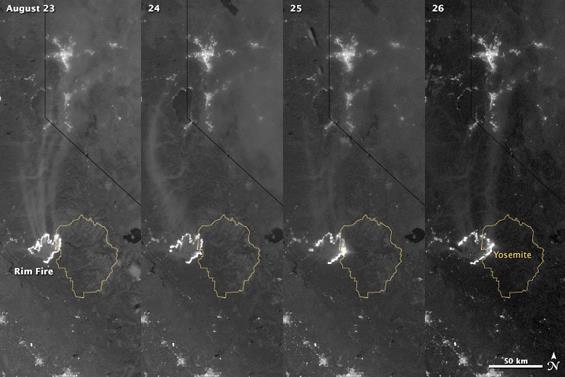
Update: California Rim Fire From Space.
Slate
has an interesting article and timelapse photo showing the spread and
intensification of one of California's largest wildfires on record;
here's a clip: "
Just a quick update to the huge Rim Fire burning in California: After I wrote the post that went up earlier today, NASA released new images of the fire taken from space. They are from the Suomi-NPP Earth-observing satellite,
taken with a camera that sees in both visible and infrared light. The
four frames show the same area over the course of four days, from Aug.
23 to Aug. 26. The thin yellow outline is Yosemite National Park, and
the fire is the thick jagged white line, detected via its heat (the
angled black line above is the California/Nevada border). You can see
the fire’s growth over time, spreading into Yosemite on the 25th and
taking firm hold there the next day..."
Photo credit above: "
The California Rim Fire seen via satellite in the visible and infrared. The growth is obvious. The city at the top is Reno, NV." Photo by
NASA/Jesse Allen and Robert Simmon/Sumi-NPP
Hurricane Season A Bust? Don't Be So Sure. I suspect
things will heat up in the tropics in September - but then again, the
way the last few years have gone with extreme weather, nothing would
surprise me. Here's a clip from
NPR: "
Back
in May, several independent forecast groups predicted an . But with
August drawing to a close, we've yet to see a single one. Despite being
hurricane-free so far, the National Oceanic and Atmospheric
Administration is that warned of between seven and 11 hurricanes from
the beginning of June to the end of November. But in case you should
think (or hope) that the 2013 hurricane season is a bust, Brian
McNoldy, a senior researcher at the University of Miami's , has done
some potentially sobering math: Writing for The Washington Post's
Capital Weather Gang blog, that while it's somewhat unusual to have no
hurricanes this late in the season, it's by no means unprecedented: It
happened in 1984, 2001 and 2002..." (Hurricane Rita file image courtesy of NOAA/NASA).
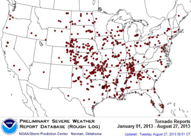
USA Having Calmest Year For Tornadoes In Over A Decade.
Cincinnati.com has a good overview of the state of tornadoes in the USA in 2013, here's the introduction: "
The
USA is seeing its quietest year for tornadoes in more than a decade. Of
course, for the victims of the savage EF-5 tornado that blasted Moore,
Okla., in May, the season was anything but quiet. That violent tornado
killed 24 people as it roared across the Oklahoma City suburbs.
Tornadoes have killed a total of 45 Americans this year, according to
data from the Storm Prediction Center. Forty-two of those killed were
in May. Still, the actual number of tornadoes is clearly low. "If we
estimate the 2013 count at about 610 tornadoes through Aug. 20, the
last year with fewer tornadoes through Aug. 20 was 2002, with 579,"
reports Gregory Carbin, warning coordination meteorologist with the
Storm Prediction Center in Norman, Okla..."
Map credit: tornado touchdowns since January 1, courtesy of
NOAA SPC.
Why Are Hurricanes Getting More Expensive.
Insurance.com has news of interesting statistics and trends in the insurance industry; here's an excerpt: "...
If
it seems as though the United States is experiencing more hurricanes
that are more destructive than ever before, it's not your imagination.
According to Munich Re—an insurance company for insurance
companies—North America's weather-related losses increased by five times
over the last three decades. Munich Re says climate change caused by
human actions is a big factor causing these changes. Nature is also
partly responsible. The number and severity of hurricanes seem to
naturally occur in cycles that last about 20 years and are spaced about
20 years apart. "The National Oceanographic and Atmospheric
Administration says we're in the middle of a cycle of more frequent
storms," says Lynne McChristian, a spokesperson for the Insurance
Information Institute. "We're in this decade of disasters." It's not
just now, either. "The long-term trend is increasing in frequency and
severity of national catastrophic events, such as hurricanes and
tornados," says Chris Hackett, director of personal lines policy for
the Property Casualty Insurers Association of America. "The top 12 most
costly hurricanes occurred in the last eight years...."
NASA's HS3 Mission Analyzes Saharan Dust Layer Over Eastern Pacific.
That dust layer, blowing off the Sahara Desert in northern Africa, may
at least be partially responsible for a lack of hurricanes in the
Atlantic. Here's an excerpt from a story at
Science Daily: "
One
of two of NASA's Global Hawk unmanned aircraft flew over the remnants
of Tropical Storm Erin and investigated the Saharan Air Layer in the
Eastern Atlantic Ocean on Aug. 20 and 21. The instruments aboard the
Global Hawk sampled the environment of ex-Erin and revealed an elevated
dust layer overrunning the storm. "Our goal with this flight was to
look at how the Saharan air would move around or into the former storm,
but the circulation was so shallow and weak that, according to our
instruments, the Saharan air simply moved westward right over what was
left of Erin..."
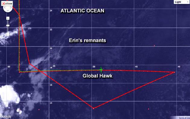
Graphic credit above: "
This infrared image from NOAA's
GOES-East satellite on Aug. 20 shows the Global Hawk crossing the
low-level remnants of Erin. Erin's low-level clouds appear as a faint
circulation. The green path is the direction the Global Hawk came from.
The red line represents the path the aircraft would follow." (Credit:
NASA/NOAA).
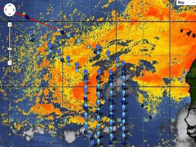
Lingering Saharan Dust Eastern Atlantic. Here's a
slightly different perspective, and one significant reason why we are
seeing a lull in Atlantic hurricane formation. The Global Hawk (drone)
was in the air for over 25 hours, sampling the air off the coast of
Africa, which still has considerable dust from the Sahara Desert, as
reported by
NASA: "
The
second science flight of NASA's HS3 mission occurred over the weekend
of Aug. 24 and 25. Global Hawk 872 studied the dry air off the African
coast and dropped 54 dropsondes during a 25.5-hour flight. The aircraft
returned to NASA's Wallops Flight Facility in Va. on Aug. 25. This
graphic shows the pattern of the weekend flight over a satellite image
of the Saharan air layer. Orange shading indicates the locations of
dry, dusty Saharan air."
National Weather Service Upgrades Could Improve Aviation Forecasts Within The Year. Some encouraging news coming from NBAA,
The National Business Aviation Association. Here's a snippet of a recent story: "
In
less than a year, U.S. aviation weather forecasts could start
improving significantly. In two or three years, today’s preflight
weather planning products may be remembered as inefficient or sluggish.
The more timely, specific forecasts will be made possible by a more
than 10-fold increase in National Weather Service (NWS) computing power,
from today’s 80 teraflops (80 trillion calculations per second) to
well over 1,000 teraflops. By comparison, a state-of-the-art desktop
computer clocks about 0.01 teraflops. “The supercomputer transition is
already well underway,” said Bob Maxson, a former hurricane-hunting
pilot on the weather service’s Gulfstream airplanes, and now director
of the Aviation Weather Center in Kansas City, MO. “This huge increase
in computing power will be revolutionary in predicting critical nuances
of aviation weather vital to pilots and other aviation users...”
The 10 Safest U.S. Cities From Natural Disasters? Head
to the Rust Belt if your goal is to avoid hurricanes, large tornadoes
and earthquakes! Many of the cities are in Ohio, which explains why a
Dayton TV station ran this story - here's a clip from
whiotv.com:
"Tapping data from the National Oceanic and Atmospheric
Administration, U.S. Forest Service and FEMA’s National Flood Insurance
Program, the real estate research firm compiled a list of the cities
around the country with the lowest risk of being flooded, rocked by
earthquakes, battered by hurricanes, struck with tornadoes or burned by
wildfires. Another benefit these safer cities enjoy: They tend to be
affordable compared to locales in places like California, Florida and
Hawaii where natural disasters are more common. There are reasons why,
say, a house in Honolulu is pricey: impeccable weather, breathtaking
views, exciting urban nightlife. But that won’t help when the earth
starts shaking..."
Photo credit above: "
Safest large city in America? Syracuse, New York". Source:
whiotv.com.
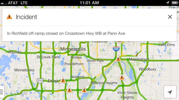
Local TV Facing Increasing Competition In Weather And Traffic.
Lost Remote has the story; here's an excerpt: "
The most popular mapping and navigational tool on the planet, Google Maps, is expanding its traffic coverage. This week the app added
traffic accidents and other incidents courtesy of Waze, the mobile
startup Google acquired for $1 billion earlier this summer. This is
just one more sign that two of local TV’s biggest drivers — weather and
traffic — are under increasing pressure from non-traditional
competitors on the platform that increasingly matters the most: mobile.
Google Maps has an incredible footprint. It’s always in the top
most-downloaded apps on iOS, and it’s pre-installed into most Android
devices. With the addition of Waze data — which is crowdsourced from its
users — Google Maps is now the most popular traffic news source by a
long shot. If you combine both Google properties, it’s a landslide,
especially if you consider Android’s incredible growth curve..."
I Met The World's Smartest Dog. My spaniel, Leo, will be jealous, but I still feel the need to post this story from a fascinating feature at
popsci.com. Yes, Chaser is one extra-bright dog. I know PEOPLE who don't know 1,000 words. Here's an excerpt: "...
Each
of the thousand or so objects Chaser knows has an individual name.
These are usually nonsense words, like "Fuzzy" or "Bamboozel" (sic) or
"Flipflopper." But to Chaser, they might as well be the names of sheep.
This could be unusual to border collies. Ranking canine intelligence
is a sticky business; Dr. Coren, for his book, ranked the dogs on their
"working and obedience intelligence," testing how quickly each breed
could learn a command and how consistently each could demonstrate that
knowledge. The border collie ranked highest, and the Afghan hound the
lowest, but Coren is quick to note that intelligence is not any one thing, and that his ranking only applies to, basically, ability to respond to commands..."
Photo credit above: "
Chaser With Fluffy." Dan Nosowitz.
23 Signs You're A Secret Narcissist. If you click on the link below that might be the 24th sigh. Salon has the article (and quiz); here's an excerpt: "...
By
this point, you’re probably wondering if you’re secretly a
hypersensitive covert narcissist masquerading as a sensitive introvert.
Without further ado, here are 23 items that will allow you to gain
greater insight into your personality. In a recent study conducted on a
group of 420 undergraduates, Cheek and colleagues found that higher
scorers on this “Maladaptive Covert Narcissism Scale” tended to also
score higher on tests of entitlement, shame, and neuroticism, and tended
to display lowerlevels of self esteem, extraversion, agreeableness,
and conscientiousness. In contrast, maladaptive overt narcissism wasn’t
related to shame, self esteem, or neuroticism, even though overt
narcissists reported feeling just as entitled as covert narcissists. It
seems if you have to be a narcissist, it’s better to be an overt
narcissist than a covert narcissist!..."
Photo credit above: "
Kanye West." (Credit: Reuters/Andrew Innerarity). Who is Kanye West?
Climate Stories...
We're Already Sick Of Climate Change - And Getting Sicker. Here's an excerpt from a book review at
Grist: "...
For her new book, Fevered: Why a Hotter Planet Will Hurt Our Health — And How We Can Save Ourselves,
Marsa, a contributing editor for Discover, traveled the country and
the world, looking for communities on the front lines — “places that
give us a glimpse of what’s coming in next 20, 30, 40 years,” she says.
The result is a finely crafted and sobering tale on par with David Quammen’s recent tome, Spillover,
only with a little less Isn’t this fascinating and a lot more.... “I’ve
done some important stories, but nothing compares to the magnitude of
this,” Marsa told us during a recent visit to Grist HQ. “Because this
threatens civilization, this threatens us as a species...”
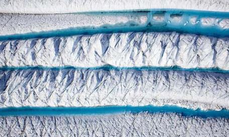
Drones Proving Useful In Polar Regions To Study The Melting Of The Ice. Here's an excerpt from
The Guardian: "
The
logical next step for exploring some of the world's most inhospitable
terrain is being taken. Researchers are using unmanned aerial vehicles
(UAVs) – drones – to explore the last great repositories of ice in Greenland, Antarctica and Alaska.
About two dozen universities and research organisations, including
Nasa and the National Oceanic and Atmospheric Administration, have
registered as drone operators, according to a list released last year
to the Electronic Frontier Foundation. Some of those researchers were
tracking wildfires or ozone concentrations, oil spills and volcano ash,
but a significant number were deployed to the polar regions to study the melting of the ice..."
Photo credit above: "
A section of the Petermann glacier in
Greenland, photographed by the 'heli-cam', a remote camera attached to
a small single engine helicopter, triggered from inside the cockpit by
remote control." Photograph: Nick Cobbing/Greenpeace.
Six Stealthy Energy Hogs: Are They Lurking In Your Home? The short answer is (probably) yes. I found this article at
National Geographic News interesting - here's a clip: "
Does your smartphone use more energy than a refrigerator? A recent report by the Digital Power Group claimed that an average iPhone uses more juice for battery charging, data use, and wireless connectivity than a medium-sized, ENERGY STAR refrigerator. But
an iPhone's power requirements vary dramatically depending on how it's
used for video, gaming, and other apps. And estimates for just how
much data the average owner uses a month also vary widely, so the
controversial study has drawn critics
who claim that the comparison is greatly overstated. Whether your
mobile phone's power use rivals your fridge or not, the chances are
good that hidden energy hogs in your home are burning more power and
money than that refrigerator—sometimes much more. Here are half a dozen
surprisingly power-hungry devices that may be feeding your electric
bill..."
Photo credit above: "
Many household devices continue to draw power even when they are not in use, adding unnecessarily to electricity bills." Photograph by Marc Wuchner, Corbis.