Relief by Sunday
Weather forecasting, as in life, is a painful
learning curve. "You'll earn a college degree to call yourself a
meteorologist, but I predict most of what you learn will be on the job"
my father told me at a tender age. Learn from your mistakes.
Ask a stock broker, financial planner, entrepreneur or CIA analyst - the future is always some unknowable shade of gray.
We have a pretty good grasp of what's happening
now, and hundreds of weather models simulate what MAY happen days from
now, with varying degrees of skill.
Which model do you trust and why? How many times
have you been burned by a similar scenario? Maybe someday we'll be
able to fully automate & computerize the forecast ("Siri" on
steroids?) but today the most reliable weather predictions tap
computers & meteorologists, who know what to believe, and when.
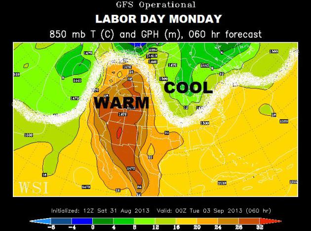
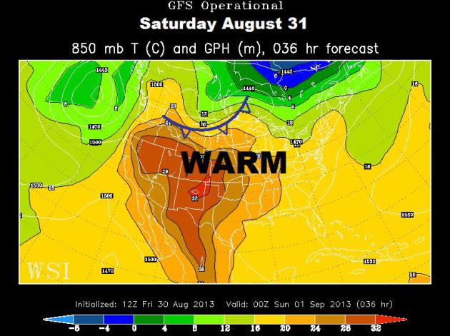
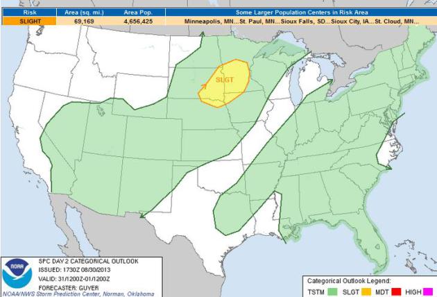
Highs approach 90 into Saturday, when a late-day T-storm marks the arrival of a refreshing front of Canadian origin.
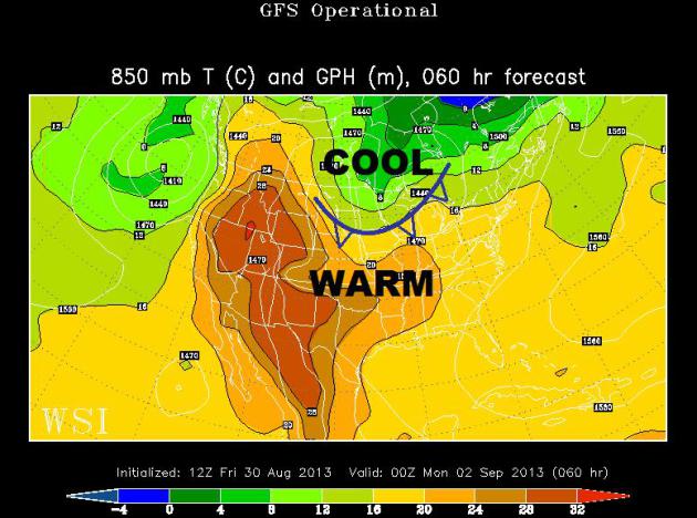
By Sunday & Monday highs hold in the 70s,
with 60s up north. Take a sweatshirt if you're heading to the cabin.
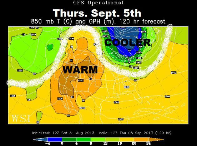
Next week looks comfortable; 70s and low 80s with lower humidity.
Students & teachers will be happier.
A perfect Labor Day for the fair? Yep.
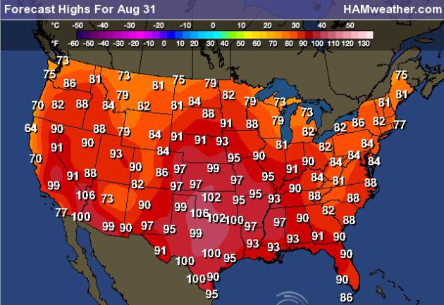
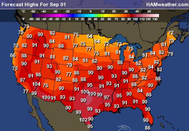
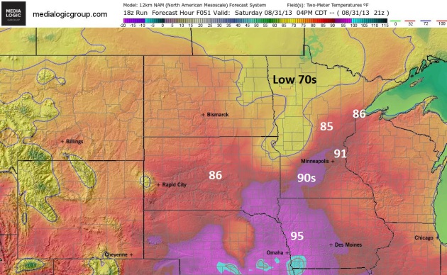
Saturday: Best Lake Day? If you're looking for
warmth, enough degrees to justify a dip in the lake or pool, consider
Saturday your best bet. Highs reach or just top 90F in the metro, 80s
extending up in the Brainerd Lakes area and Duluth. But from Detroit
Lakes to Bemidji, closer to an advancing cool front (with more clouds,
showers and T-storms) temperatures may not get out of the low to mid
70s. Map: Ham Weather.
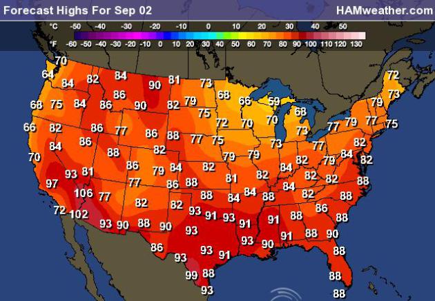
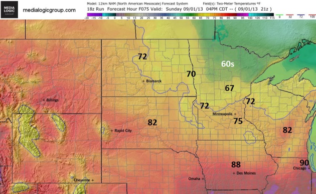
Sunday: Free A/C. Under a mostly sunny sky with a
brisk northwest breeze (10-20 mph) temperatures will hold in the low to
mid 70s over the southern half of Minnesota, holding in the 60s north
of Little Falls and Alexandria. In the sun it should feel pretty good
out there, but expect a choppy lake with those stiff northwest winds.
Map: Ham Weather.
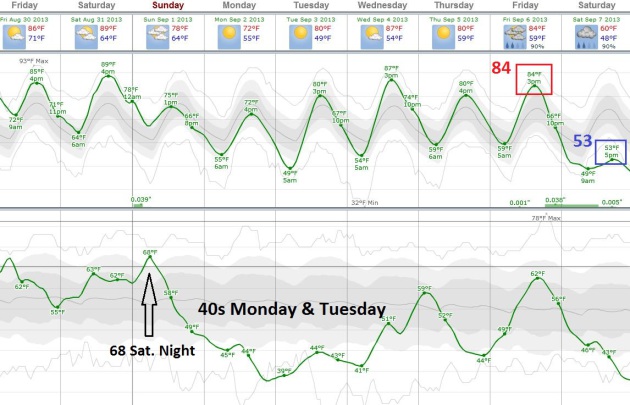
Temperature Roller Coaster.
After peaking in the upper 80s and low 90s Saturday, a fresh surge of
Canadian air drops highs into the 70s Sunday and Labor Day, then we
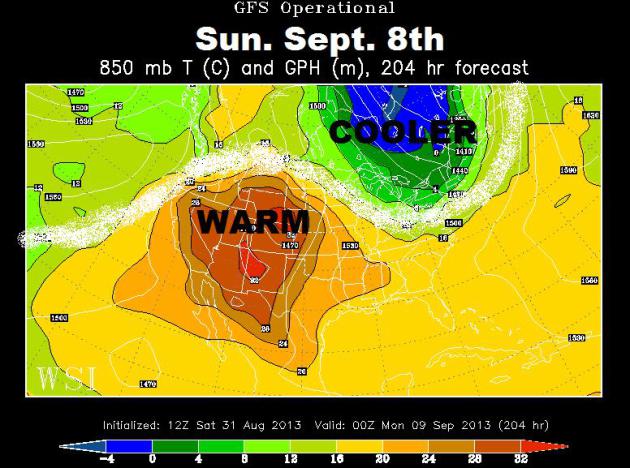
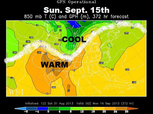
warm back up into 80s the latter half of next week. I hope the ECMWF is
temporarily out to lunch, because it shows us falling off a
temperature cliff by next weekend, a high of 84 a week today, then 30
degrees cooler on Saturday. Dew points in the sticky 60s linger into
Saturday night, falling into the 40s by Labor Day and Tuesday before
returning to muggy levels by midweek. Hang on. Chart: Weatherspark.
Shifting Gears.
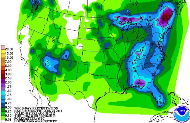
The arrival of air that's 20-25 degrees cooler will set off a smear of
heavy showers and T-storms from the U.P. of Michigan into New England,
where some 1-3" rainfall amounts are possible. Expect a soaking from
the Florida Panhandle into the Ohio Valley, more heavy rain and flash
flooding potential for northern Arizona.
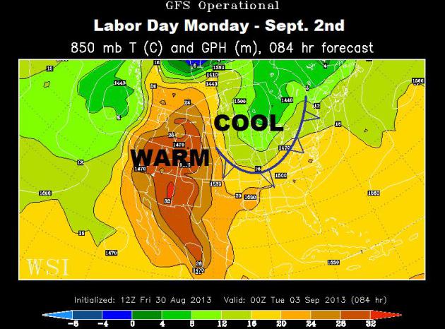
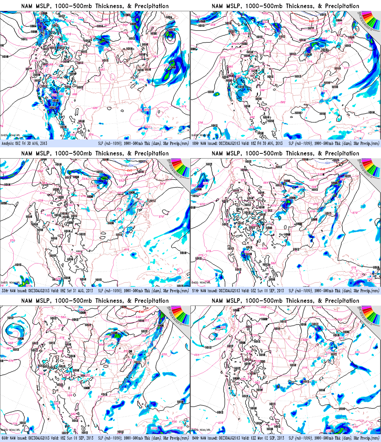
Parade of Cool Fronts. The
84 hour NAM model (NOAA) shows a series of Canadian fronts sweeping
across the northern tier of the USA, sparking a few waves of showers and
T-storms. The tropics remain quiet, monsoon-related showers and
T-storms over the southwest USA.
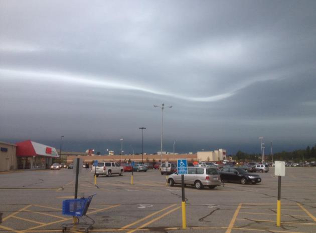
A Sinister Sky. Thanks to Jim Plucinak for snapping
this photo of an advancing squall line in the Duluth area Thursday; an
inversion (warmer air aloft) creating the smooth, laminar, lens-like
cloud formations ahead of the advancing thunderstorm wedge.
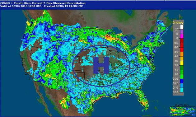
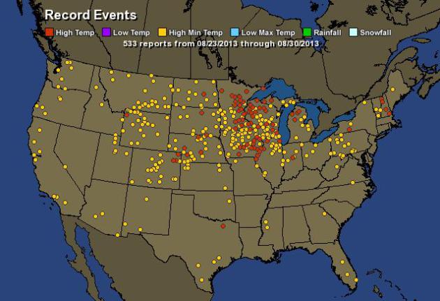
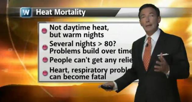
Record-Setting Late Summer Heat Wave. Residents of
the Midwest are losing their sense of humor when it comes to hot and
humid. Add dew point and heat index to the list. It feels more like the
4th of July than Labor Day Weekend. But there are signs that the Heat
Bubble stalled over the nation's midsection will shrink and migrate
south, setting the stage for a welcome taste of September by Sunday and
Monday. Heat-related school closings in Minneapolis are a reminder that
heat is America's #1 weather-related killer and needs to be taken very
seriously. It's not so much the daytime highs, but unusually warm,
sultry nighttime temperatures that can build over time, taking a toll,
especially on the elderly and chronically ill. We take a look at unusual
late-season heat in today's
Climate Matters: "
WeatherNationTV
Chief Meteorologist Paul Douglas looks at the recent heatwave in the
Midwest. Schools are closing and there are unfriendly reminders of
deadly heatwaves of the past. When will we see relief?"
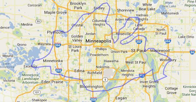
Fiery Perspective. If you were to superimpose the
Yosemite Rim Fire over the Twin Cities it would stretch from Excelsior
to Woodbury, from Fridley to Bloomington and Inver Grove Heights. It is
now the 6th largest wildfire in California history. Map credit:
mapfrappe.com.
Why Big, Intense Wildfires Are The New Normal. National Geographic takes a look at California's Rim Fire at Yosemite as a new piece in a larger puzzle - here's a snippet: “...
This
probably is the new normal,” he says. “If we look at how the climate
has changed over the past 50 years—with warmer temperatures increasing
beyond what we used to see in the early part of the 20th century, and
changes in precipitation—fires will continue to happen and get worse
and worse,” says Wuebbles, who co-authored a draft federal report
linking climate change to an increase in severe weather trends. The
numbers certainly back him up: Wildfires are roaring through twice as
many acres per year on average in the U.S. than they were 40 years ago,
U.S. Forest Service Chief Tom Tidwell told the Senate in June. That number could very well double again in the next 30 years, says Wuebbles..."
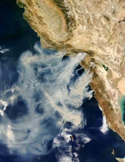
Image credit above: "A satellite image of the 2003 Cedar Fire in San Diego County, known as the largest single fire in modern California history." Photograph courtesy Jacques Descloitres, MODIS Rapid Response Team, NASA GSFC.
Money To Burn - Paying To Fight California's Wildfires. Here's a clip of an Op-Ed at
The Los Angeles Times: "
In seven weeks, California has burned through more than a quarter of its state firefighting budget of $172 million. The Rim fire in and around Yosemite alone
has chewed up 15% of that budget, and the fire season is in its early
days yet. Statewide, California 2013 has gotten maybe a quarter of the
rainfall of California 2012. The Rim fire is the seventh largest in the
state’s history. The average wildfire is now five times bigger than it was 30 years ago. Get my drift? The blaze business as usual isn’t going to cut it. Conflagration is the new normal..."
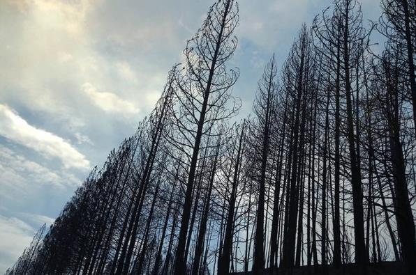
Photo credit above: "A blue sky behind a stand
of charred ponderosa pines along Highway 120, burned by the Rim fire
that has eaten up more than 230 square miles and 15% of the state's
firefighting budget." (Don Bartletti / Los Angeles Times / August 26, 2013)
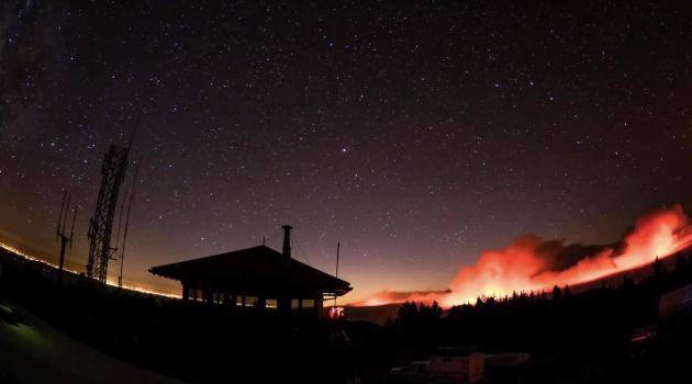
Amazing Yosemite Fire Time Lapse. Check out this remarkable YouTube clip, courtesy of Yosemite National Park: "Time-lapse
photography shows various perspectives of the 2013 Rim Fire, as
viewed from Yosemite National Park. The first part of this video is
from the Crane Flat Helibase. The fire is currently burning in
wilderness and is not immediately threatening visitors or employees.
The second half of the video is from Glacier Point, showing Yosemite
Valley, and how little the smoke from the fire has impacted the Valley."
Busted: Dieting Myths. There are a few interesting
nuggets here I wasn't aware of. Yes, it's kind of sad I feel inclined to
include dieting tips in my (alleged) weather blog. Tomorrow: favorite
hair care products! Here's an excerpt from
lifelonghealth.com:
Dieting Myth 1: Eating Fat Makes You Fat
"The name says it all: Fat makes you fat, right? Wrong! Eating a
small amount of fat actually helps you feel fuller faster as it
triggers satiety (or fullness) signals, causing you to eat less
overall. Not only that, eating the right fats aids in the absorption of
healthy vitamins. Seek out the polyunsaturated fats you’ll find in
liquid oils, like canola and safflower oil. Unlike saturated fats, they won’t raise bad blood cholesterol levels and may even reduce the risk of a heart attack.
To get your healthy fat fix, also look for omega-3 oils from fish,
krill, seafood, algae, flaxseeds and/or walnuts, and olive oil, which is
a source of both monounsaturated fats and omega-3s..."
95 F. high in the Twin Cities Thursday.
78 F. average high on August 29.
93 F. high on August 29, 2012.
7 days above 90 F. in August. Average is 3.
4 days of 95 F. or higher this week - making it the hottest Minnesota State Fair on record.
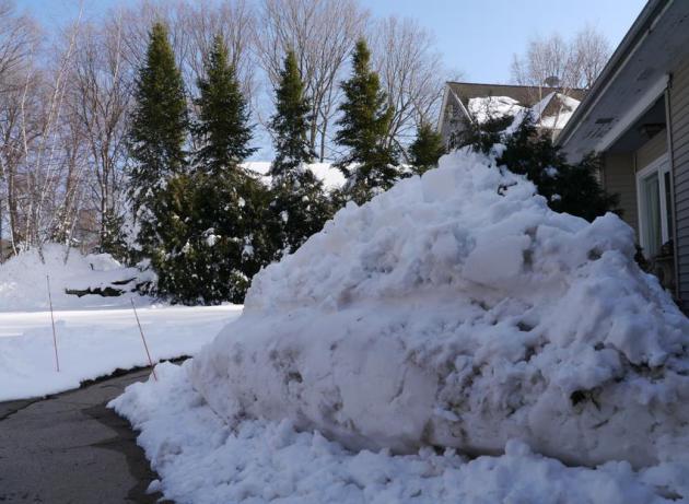
Perspective. I'm still not complaining too loud
about the heat, the dew point, the heat index. Because it wasn't all
that long ago that we were cursing spring. We earned this heat. Photo
above taken on Memorial Day. I think.
Climate Stories...
World On Fire: Climate, Population And Intensifying Wildfires. Time Magazine
has more information on the trends we're seeing, especially in the
western USA, which continues to dry out over time. Here's a clip: "...
Forest fires in the West do seem to becoming more common. A University of Arizona report
in 2006 found that large forest fires have been happening more often
in the western U.S. since the mid-1980s, a period when temperatures
have been on the increase. A 2012 study
found that climate change is likely to significantly change the fire
pattern around the planet by the end of the century, with increases
projected in the high-altitude boreal forests in the northern hemisphere
— which happens to include places like Yosemite. Climate change is
expected to increase periods of intense heat and intense dryness, even
as precipitation increases globally overall. That’s a formula for more
fires..." (File image: NASA).
Global Warming And Oceans: What Are The Known Unknowns? Here's an excerpt of an article at
The Guardian authored by St. Thomas University climate scientist John Abraham: "...
The paper found that while all the evidence shows the Earth is warming, without pause,
there are still unanswered questions and unmeasured parts of the
oceans. Underneath ice sheets and deep in ocean basins are just two
regions that need more attention. One of the world's pre-eminent
oceanographers for, among other things, his important work measuring heat transferred to very deep ocean waters,
is Dr. Gregory C. Johnson. Dr. Johnson works as an oceanographer at
NOAA's Pacific Marine Environmental Laboratory in Seattle, Washington;
he is also a co-author on the paper. He notes, "This review points
to the need to expand the innovative, year-round, broad-scale
measurements of the upper half of the open ocean volume so successfully
pioneered by the international Argo Program all the way down to the
ocean floor and into the ice-covered polar regions, so we can make
well-resolved, timely, and truly global assessments of the amount of
heat being absorbed by the ocean..."
Photo credit: "
Most global warming is absorbed by the world's oceans." Photograph: Alamy.
Scientists Leave GOP Due To Attitudes Toward Science. Here's an excerpt from an article at the
Salt Lake Tribune: "
Scientists used to be well represented among the nearly half of Americans who voted Republican. But that’s changed over the years, and one poll found that just 6 percent
of scientists call themselves part of the GOP now. What happened?
There might not be textbook answers, but there are theories. Barry
Bickmore, a professor of geology at Brigham Young University and
onetime Republican caucus delegate in crimson-red Utah County in the nation’s reddest state,
has pondered the issue at length. He contends his party is
increasingly ruled by zealots and a demand for "ideological purity"
that turns off scientists..."
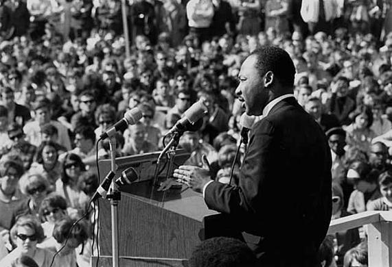
Climate Change And Dr. Martin Luther King Jr.'s Call To Remain Awake.
The Huffington Post has the story - here's a clip: "...
For
the Americans watching Washington in action today, our policymakers
look anything but awake. We're stuck in a place where many of our
leaders are actively choosing to block progress, following a path that
ensures that little to nothing gets accomplished. In Dr. King's
framework, they have chosen to sleep. Sadly we all paying the price. But
we must also not let their inaction determine our fate. As I read on,
another passage in the sermon also struck me: "Through our scientific
and technological genius, we have made of this world a neighborhood
and yet we have not had the ethical commitment to make of it a
brotherhood. But somehow, and in some way, we... must all learn to live
together as brothers or we will all perish together as fools. We are
tied together in the single garment of destiny, ... And whatever
affects one directly affects all indirectly..."
File Photo credit above: Wikimedia Commons. "
Martin Luther King, Jr., speaking against the Vietnam War, St. Paul Campus, University of Minnesota."
Peak Oil: A Fertile Concept. Has "peak oil" merely been delayed by breakthroughs like fracking? Here's a clip of an interesting article at
Cassandra's Legacy: "...
What
happened, instead, was that large amounts of financial resources were
invested into the exploitation of everything that could possibly be
drilled, fracked, smashed, squeezed, boiled, or otherwise processed in
order to get a few drops of precious, combustible liquids, and that is
what has avoided decline, up to now. But this result has come at a
high price; higher than anyone could have imagined. One problem is
that all this tremendous effort is simply postponing the unavoidable.
When decline will start, it may well be much faster than its “natural”
rate along the bell shaped curve....The real trouble is rapidly
emerging in terms of accelerating climate change, with all the costs
and dangers involved. We are seeing today the conclusion of a debate
that had started with the beginning of the peak oil movement. Is peak
oil more important than climate change? And, is peak oil going to save
us from catastrophic climate change by forcing us to burn less fuels?
Initially, the hope was that, yes, peak oil would have saved us
willy-nilly from destroying our own planet. Unfortunately, however, it
is starting to appear clear that this hope was misplaced. The
impending peak is actually worsening the climate problem because it
has led the industry to exploit less efficient, and hence more
polluting, resources..."
