5,322 daily records in the last week, nationwide. Source: NOAA

One Week's Worth Of Records. Here is the latest Ham Weather map, showing 24-hour records for the USA in just the last 7 days. Here's a breakdown:
| Total Records: | 5322 |
| Rainfall: | 727 |
| Snowfall: | 49 |
| High Temp: | 2065 |
| Low Temp: | 42 |
| Low Max Temp: | 80 |
| High Min Temp: | 2359 |
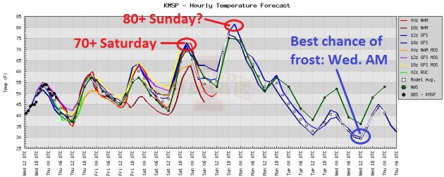
50 Degree Temperature Drop In 60 Hours? After topping 80 Sunday, the mercury tumbles Monday and Tuesday, gusty winds keeping the air stirred up, preventing a frost until (possibly) Wednesday morning, when the combination of clear skies and light winds may trigger a frost, especially over the suburbs.
"Planting crops right now warrants caution, since there is still a possibility for a 32-degree freeze to occur, or even a 28-degree “hard” freeze, which could kill plants that have emerged. Crop insurance policies do not cover replanting costs if farmers plant before the earliest seeding date, which is April 6 in most of Illinois, Indiana, and Ohio and April 11 in Iowa and Minnesota." - from a MRCC press release, more details below.
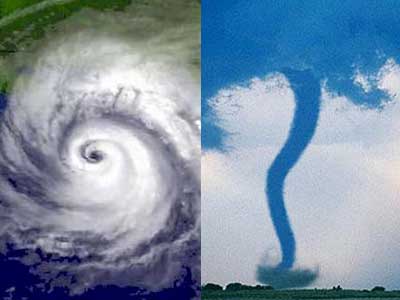
"In human cost, it was an astounding year: more than 600 deaths nationwide from nearly 1,900 tornadoes and 30,000 total severe weather events - none other like it in many decades." - from a WLOX-TV story below.
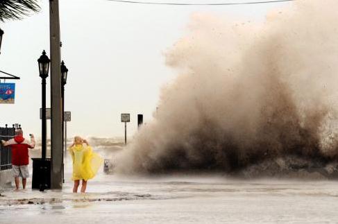
"The tentative new products include a storm surge map that shows how far inland and how deep seawater is likely to flow into communities as a storm approaches. Another shows only a storm surge warning area, similar to the National Weather Service maps that show tornado and severe thunderstorm warnings." - from a Herald Tribune article below documenting the changes NHC is making to hurricane predictions and tracking for 2012. Photo: NOAA.
"For extreme heat waves and unusual downpours, the answer, Coumou and his colleagues found, is yes. “The evidence is solid,” he said: Extra heat in the atmosphere from human-caused greenhouse gases has made these two types of events much more likely. The climate has already changed, and the sheer number of these events over the past decade reflects it, they find." - from a Washington Post article, details below.

"Though modest in size, the clean economy employs more workers than the fossil fuel industry and bulks larger than bioscience but remains smaller than the IT-producing sectors." - from a 2011 study on clean energy and jobs from The Brookings Institute.
4.25" diameter hail reported at Madison, Kansas at 8:57pm Wednesday evening.
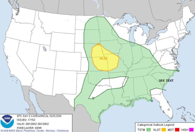
Thursday Severe Risk. A few storms may exceed severe criteria (58 mph. wind gusts and/or 1" diameter hail) from Omaha to Kansas City to Des Moines. Source: SPC.
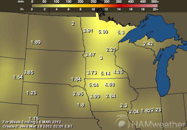
Palmer Drought Index. Here is the approximate amount of rain it will take to pull us out of a drought; anywhere from 2-6" of rain across most of Minnesota and much of Iowa. Wisconsin and the Dakotas are in slightly better shape with soil moisture. Map courtesy of NOAA and Ham Weather.
Tsunami Drills. From the NWS in Alaska: "Between 9:45am and 10:15am (Wednesday) morning, the National Weather Service and Alaska's Division of Homeland Security and Emergency Management will be conducting a tsunami warning drill. During that time, you may hear sirens and, if you are watching TV or listening to the radio, you may hear a message that says a tsunami warning has been issued for Alaska. Please keep in mind that this is only a test."
"Wedding Insurance" for your big day? Read on...
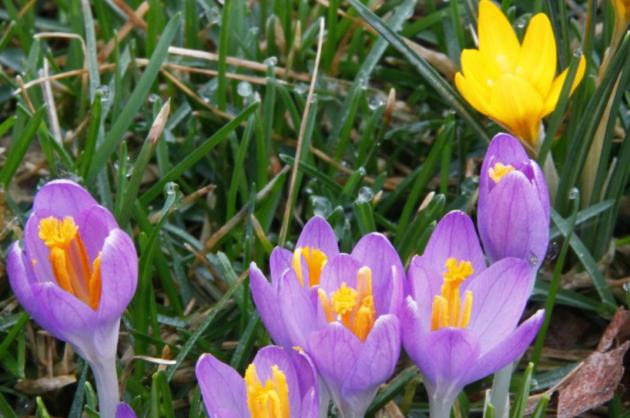
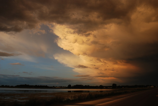
Crocus-Cam. Thanks to Broadcast Weather meteorologist Aaron Shaffer for reminding us how amazing flowerbeds and gardens are looking out there - about a month ahead of schedule. I fear some of these tender flowers will freeze their buds off by Tuesday of next week; best chance in the outlying suburbs.
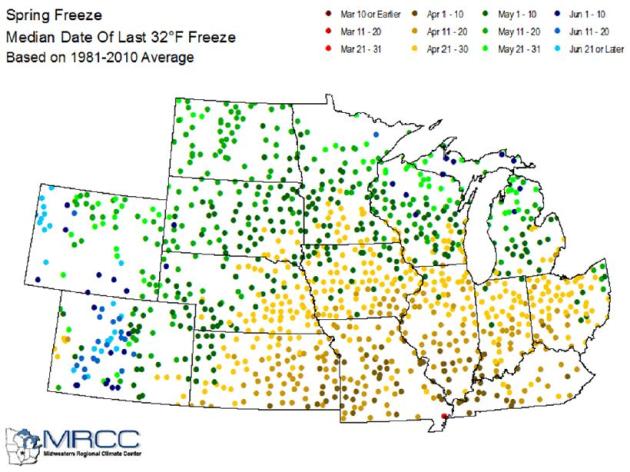
Too Early To Plant/Farm? Here's a portion of a Wednesday press release (pdf) from MRCC, The Midwestern Regional Climate Center in Champaign, Illinois: "The warm temperatures and relatively dry soil have prompted farmers to think about planting their corn crop early this year. There are reports of farmers planting corn in Illinois, Iowa, and Missouri about two to four weeks early. In addition, residential gardeners may also plant early because of the warm temperatures....A majority of Iowa, Minnesota, Wisconsin, Michigan, and Ohio have not experienced a growing season that has started before April (see Figure 2). Planting crops right now warrants caution, since there is still a possibility for a 32-degree freeze to occur, or even a 28-degree “hard” freeze, which could kill plants that have emerged. Crop insurance policies do not cover replanting costs if farmers plant before the earliest seeding date, which is April 6 in most of Illinois, Indiana, and Ohio and April 11 in Iowa and Minnesota.
Record Season Accelerates Growing Season And Potential For Plant Damage. Here's a timely post from the Green Bay office of the NWS: "Most springs, the growing season doesn’t begin in northeast and north-central Wisconsin until late April or early May. This is normally when the NWS frost and freeze program begins. However, the recent stretch of record setting summer-like warmth has caused the growing season to begin four to six weeks earlier than normal. As a result, the NWS Green Bay office will begin issuing advisories for sub-freezing temperatures so those with sensitive vegetation can mitigate the impact of the cold during this early spring. Freeze Warnings will be issued for northeast and north-central Wisconsin when temperatures of 28 F or lower are anticipated. Frost will be forecast when temperatures of around 32 F or lower are expected with the formation of frost, but Frost Advisories will not yet be issued due to the more limited impact these temperatures have on existing agriculture. As the spring progresses, normal advisories for frost and freeze conditions will resume." Photo above: Ron Edmonds/AP.
Our Evolving Winters. Here's a portion of a press release from "On Thin Ice" a new paper from the National Wildlife Federation: "Since the 1970s, winter temperatures have been increasing across the northern United States, from 1 to 2 degrees F in the Pacific Northwest to about 4 degrees F in the Northeast. The season is also getting shorter, with spring now arriving as much as two weeks earlier than it did just two decades ago. And winter is becoming less white: The extent of snow cover across the Northern Hemisphere has decreased by approximately 3 to 9 percent since 1978, with especially rapid declines in the western United States. Climatologists expect these trends to continue, and they project that by the end of the century, parts of the Northeast will lose as many as half of their snow-covered days each year." Photo: Aaron Shaffer.
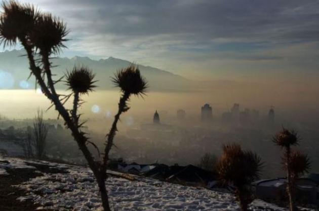
Did Winter Forget The Great Lakes? Here's an interesting post from NOAA's Satellite And Information Service: "A notable stretch of record warm temperatures across the upper Midwest has done quite a bit of damage to the already low Great Lakes ice pack. Thousands of daily record high temperatures were set as temperatures exceeding 80 degrees, in areas where normal highs are in the upper 30s/lower 40s. The ice cover across the lakes has been well below normal for much of this season, but this latest warm spell has brought levels to the lowest extent seen in over 30 years. The National Ice Center is a multi-agency operational center operated by the United States Navy, the National Oceanic and Atmospheric Administration, and the United States Coast Guard."
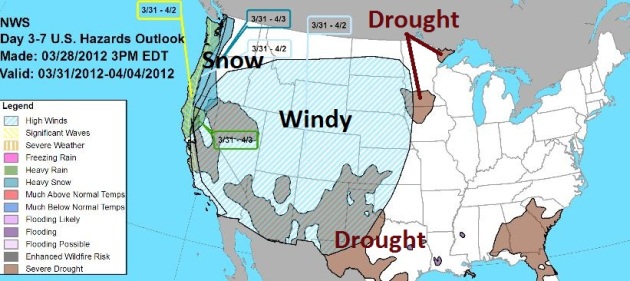
Significant Weather Threats Day 3-7. NOAA has a special graphic summarizing the weather threats for Days 3-7. With the core of the jet stream dipping south, meaning frequent storms and huge temperature swings, expect unusually windy conditions over the western 1/2 of the USA; heavy snow for the Sierra and Cascade range out west, lingering drought for the southwest, southeast and parts of southern MN and the Arrowhead.
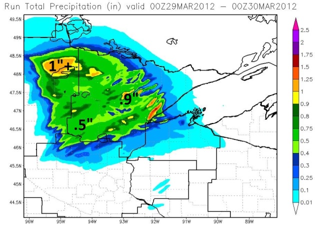
Significant Rain Sails North. The Duluth office of the NWS runs a local WRF model, which is predicting close to 1" of rain over Bemidji, closer to .5" rain for Brainerd, nearly .8-.9" around Duluth - a mix of rain and snow.
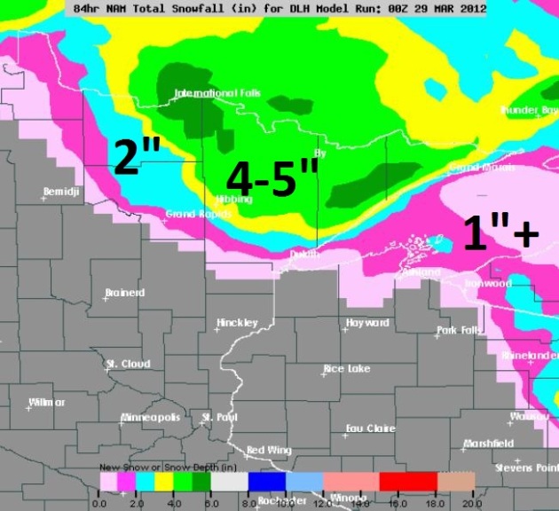
Looks Like S-N-O-W. The latest NAM model prints out 4-5" snow north of Duluth, for much of the Minnesota Arrowhead. No, we won't see any snow here in the metro, but this is a little close for comfort.
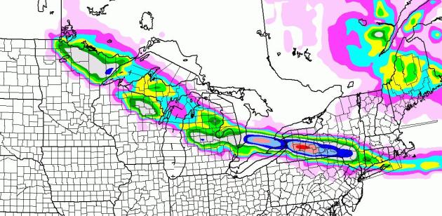
Snowy Stripe. An atmospheric tug-of-war will spark a potentially "plowable" snowfall from the Minnesota Arrowhead into northern Wisconsin, Lower Michigan and upstate New York. Yes, that's 6" for the Hibbing area, maybe 1-3" for Duluth, according to the latest NAM model. Yikes.
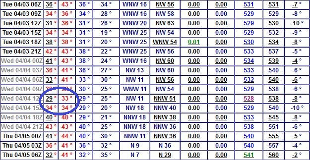
Uh Oh. Based on the latest data I don't see a widespread, killing freeze in the metro, meaning a few hours colder than 28 F. But a frost is likely by next Wednesday morning in the outlying suburbs, possible in the close-in suburbs.
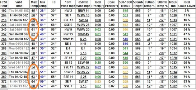
April Warming Trend. The latest runs don't look quite as chilly for the second week of April - a few days in the 50s, but plenty of 60s between April 7-13. Data: NOAA GFS.
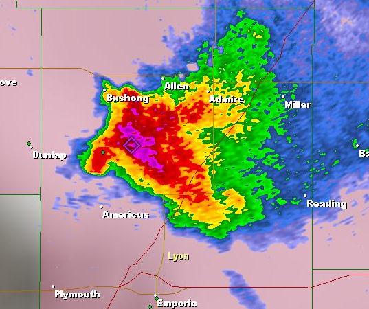
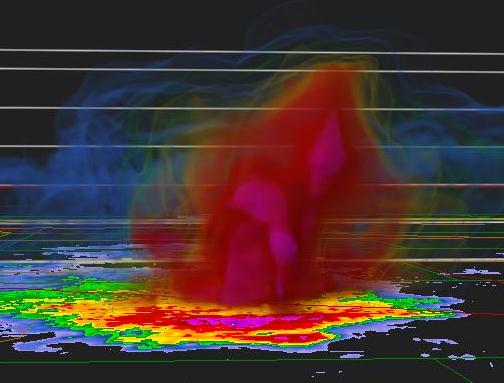
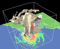
Anatomy Of A "Supercell". Here is the rotating mesocyclone that spawned 4"+ diameter hail north of Emporia, Kansas Wednesday evening, with a few confirmed tornado touchdowns. The (GR2 Analyst) image upper left shows traditional reflectivity, the pulse of NWS Doppler reflecting off of rain and hail - a classic "hook shape" to the rotating cell. The image upper right shows a 3-D cross-section of the same supercell, showing the faint outline of a powerful updraft capable of keeping baseball-size hail aloft, and the shear necessary for tornadogenesis. Thanks to Broadcast Weather meteorologist Todd Nelson for passing this along.
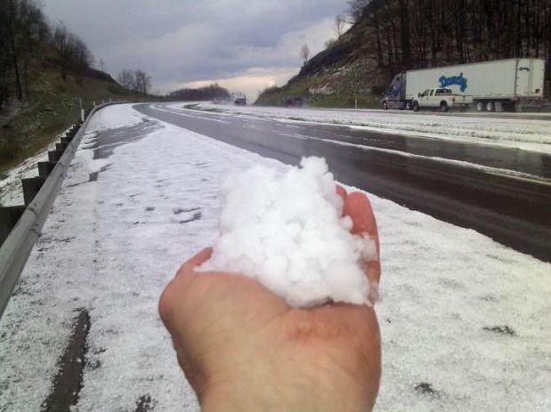
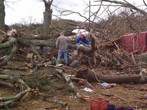
Hail And High Water. The freezing level was closer to the ground than usual over West Virginia yesterday, a puddle of cold air swirling aloft. Nathan Rohrbough took this photo in Lewis County, West Virginia. Nicely done!
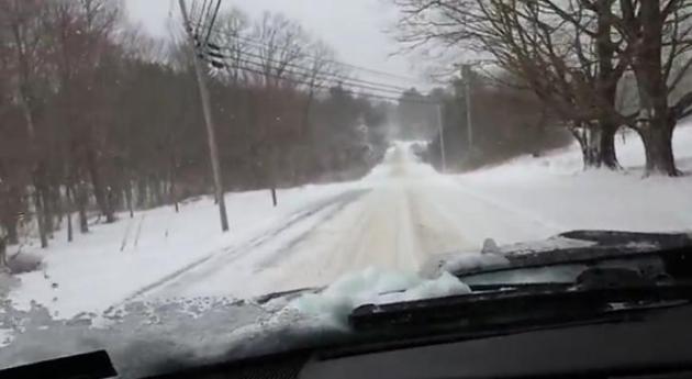
Winter Flashback. Yep, it looks like....March...over upstate Maine. Here's the YouTube clip of snowcovered roads, sent in by jon18savage. Ah...brings back memories best left forgotten.
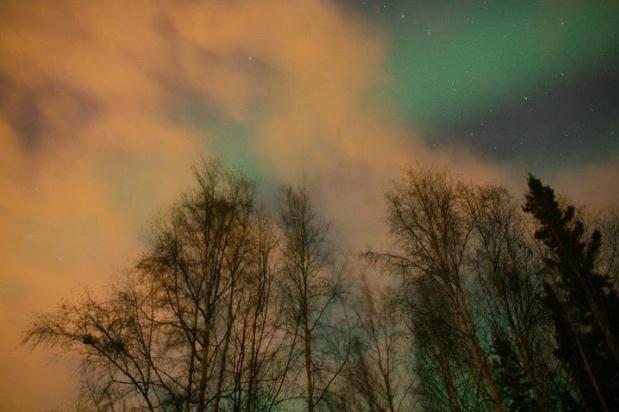
View From The North Pole. It was a stunning Aurora Borealis visible at North Pole, Alaska late Tuesday night - image courtesy of the Alaska office of the National Weather Service, via my dear friend Mark Zuckerberg at Facebook.
Report: Over 600 People In U.S. Died During Weather In 2011. Al Conklin, Chief Meteorologist at WLOX-TV has the details: "ORLANDO, FL (WBTV) - Major tornado outbreaks, land falling hurricanes and even a freakish Halloween weekend snowstorm in the Northeast combined to make 2011 the worst year on record for federally declared disasters. In human cost, it was an astounding year: more than 600 deaths nationwide from nearly 1,900 tornadoes and 30,000 total severe weather events - none other like it in many decades. Crunching the numbers, overall losses to the American economy added up $77 billion. More than half of those losses were covered by insurance providers, one of the costliest to the industry on record, and a that could be a troubling sign. With 2012 off to an unusually busy start - already 55 deaths resulting from 375 tornadoes across the Midwest and South - insurance rates for homeowners and business may spike with the weather."
Major Overhaul To Hurricane Warning System. The Herald Tribune has a timely story - hurricane season is a little more than 2 months away: "Sweeping changes are in the works for the National Hurricane Center's visual warnings on tropical weather, and this time scientists want to make sure the public understands them. Within a few years, the cone of uncertainty, which shows a hurricane's predicted path, will likely be obsolete. Too many people misinterpret it as a forecast for hurricane winds. Also, new warnings and maps for storm surge are likely to emerge, a move that will bring the largest change to the hurricane center's warning program in decades. Hurricane Ike is the driving force behind the changes, said Jamie Rhome, a storm surge specialist with the National Hurricane Center. In 2008, Ike's enormous storm surge trapped thousands of people in Galveston and nearby coastal areas because they did not evacuate, despite pleas from the National Weather Service."
Hurricane Myths Debunked. WAFB-TV in Baton Rouge, LA has a terrific story, trying to put to rest potentially dangerous old (husband's) tales about hurricanes. A number of people still confuse tornadoes and hurricanes: "Turns out some common strategies people used to keep themselves safe from hurricanes aren't as safe as you think. Climatologist Bill Keim has heard dozens of hurricane home safety remedies over the years; taping windows is just one of them. "The tape is not gonna really help you keep it from getting knocked out, but if it does get knocked out it keeps the glass from shattering and going all over the place and creating other health hazards," said Keim. Others swear by cracking windows around the house, to balance the outside versus inside air pressure. "All that really does is allow the storm to get inside of your house...the wind," said Keim. "And that's only gonna create more damage, so that is not wise in either a hurricane or a tornado."
"Ask Paul". Weather-related Q&A.
Paul -
I enjoy reading your blog….
Don't know if you have seen this or not, bur it is a very interesting way to look at wind patterns in the US…
John Uppgren, TechBarn.com
Thanks John - this is one of the best visualizations of wind I've ever seen. It's not current, but rather predicted winds, based on NOAA NDFD forecast data. Very nice - thanks for sharing!
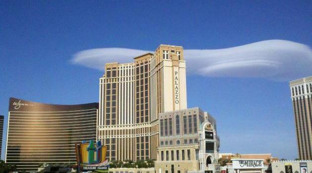
Photo Of The Day. Do NOT call 911. This is not a UFO, although the fact it was hovering over Las Vegas does make me stop and wonder. Details from the Las Vegas NWS, via Facebook: "Yesterday evening between 5 and 5:30 lenticular clouds could be seen in the sky over Las Vegas. Lenticular clouds are lens shaped clouds that form at the crest of air flowing over mountains. They are usually associated with strong flow over mountains, which is then forced downward upon encountering a stable layer. As the air ascends, it cools and reaches its dew point temperature. The water vapor in the air condenses, forming a cloud. The stable layer then forces it to descend – often warming it enough for the condensed water to evaporate back to vapor putting a break in the cloud. When a strong enough wave exists, lenticular clouds can ebb and flow continuously."
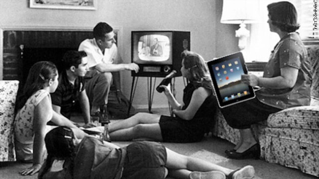
ABC And Nielson Measuring iPad Behavior. You know this was coming - so many people are watching their favorite shows on iPads (which, up until recently, haven't been counted in the all-important "ratings"). That's changing, and programmers are probably breathing a collective sigh of relief. Details from TVNewsCheck.com: "Disney/ABC Television Group’s ABC Research team and Nielsen today announced a new initiative to determine how people use iPads, for video consumption and other activities. Disney/ABC said that with Apple now reporting more than 55 million iPads sold to date and 3 million new iPads sold since March 16, “the importance of understanding how, when and where consumers use tablets is a top priority for the media industry.” Photo above courtesy of an article about iPPad usage cutting into traditional TV viewing time at CNN.
"Television has proved that people will look at anythign rather than each other." - Ann Landers
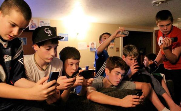
"Second-Screen Viewing." This photo sums up what's happening right now with media consumption better than anything I could explain. People are watching TV (with one eye), while fiddling with their smart phones and iPads. LostRemote.com has details: "We all know that kids thrive on mobile devices and love to multitask in front of TV, but sometimes a picture is worth a thousand words. Scott Macklin, associate director at the awesome MCDM program at the University of Washington, shared with me this photo of his son, Case, and his friends watching the Super Bowl."
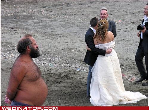
"Wedding Protector" Plan Insurance - Why Leave Anything To Chance? It was only a matter of time before this idea became a business reality. Now if your Big Day gets rained out with monsoon floods - you get your money back. Pretty cool. Details "The Wedding Protector Plan®, underwritten by travelers, urges brides and grooms to consider insuring their investment and deposits for their upcoming wedding. The wedding and event insurance provides coverage for many problems including severe weather that may be avoided if insured properly. Tornado season is upon us and hurricane season is looming close behind. Already a record number of tornadoes have swept across the United States this year, which could set the stage for the intensity of the upcoming hurricane predictions. According to TheKnot.com, there were 6,031 weddings planned for Aug. 26 through Aug. 28 in areas affected by Hurricane Irene."
Photo credit above: wedinator.icanhascheezburger.com.
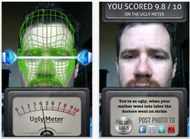
A Perfectly Good Waste Of 99 Cents: "Ugly-Meter". O.K. I heard this on Howard Stern. Please don't judge me. For the record I go back and forth between Stern, NPR and Bloomberg Radio on my trusty Sirius Satellite Radio. Yeah - I'm a mess. Apparently this app looks for symmetry of facial features when determining "beauty", or lack thereof. What a great party treat! More details from the iTunes Store.
A Very Green March
"It was one of those March days when the sun shines hot and the wind blows cold: when it is summer in the light, and winter in the shade," wrote Charles Dickens.
What a wondrously fickle March. We've had a couple of bad hair-days, the result of jet stream winds howling overhead, and big temperature swings. The greater the contrast in temperature, the faster the winds have to blow to keep the atmosphere in equilibrium.
I'm hearing reports of farmers out doing fieldwork and prep for spring planting. Go slow. The risk of frost, even a killing freeze, is quite high in April. The mean date of the last 32F at MSP? April 29.
According to the Midwestern Regional Climate Center "Despite the early warmth, climatology tells us that the possibility for a freeze in April remains high, putting emerging plants and crops at risk". Apple and peach trees are blossoming in Wisconsin! It reminds me of 2007, when we had early warmth, followed by an Easter freeze.
Showers arrive tonight; a warm front boosting the mercury into the 70s Saturday, low 80s Sunday? Monday showers usher in colder air - a frost is very possible Wednesday morning, before warming back to near 70 late next week.
Hold on!
"The activist is not the man who says the river is dirty. The activist is the man who cleans up the river." - Ross Perot
Reports Link Heat Waves, Deluges To Climate Change. Here's an article from The Washington Post: "Scientists are increasingly confident that the uptick in heat waves and heavier rainfall is linked to human-caused greenhouse gas emissions, posing a heightened risk to the world’s population, according to two reports issued in the past week. On Wednesday, the U.N. Intergovernmental Panel on Climate Change released a 594-page study suggesting that when it comes to weather observations since 1950 there has been a “change in some extremes,” which stem in part from global warming."
Climate Change To Drive Weather Disasters; UN Experts. Here is an excerpt of an AFP story on the just-released 592 page study: "The report made these points:
-- Since the 1950s, record-breaking daily temperatures and heatwaves have become more frequent or lasted longer, according to strong evidence. There is a 90-100 percent probability that this will continue through the 21st century.
"The hottest day, which today occurs once every 20 years, is expected to occur once every second year by the end of the 21st century," said climate physicist Thomas Stocker.
This scenario is based on the assumption that today's high emissions of greenhouse gases continue unabated, he explained.
-- Extreme rainstorms have intensified over past decades and are likely to become more frequent in this century, although with big differences between regions.
-- Southern Europe and West Africa have already experienced bigger or longer droughts. This century, central Europe, central North America, central America and Mexico, northeast Brazil and southern Africa could follow suit.
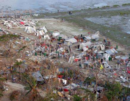
Global Warming Linked To Deadly, Costly Weather Disasters. More details from USA Today: "The greatest danger from extreme weather is in highly populated, poor regions of the world, the report warns, but no corner of the globe — from Mumbai to Miami — is immune. The document by a Nobel Prize-winning panel of climate scientists forecasts stronger tropical cyclones and more frequent heat waves, deluges and droughts. The 594-page report blames the scale of recent and future disasters on a combination of man-made climate change, population shifts and poverty."
Photo credit above: Photo of Cyclone Sidr aftermath in Bangladesh (2007) courtesy of Ezekiel R. Kitandwe/AP.
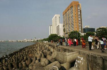
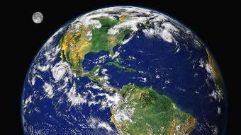
Climate Change Report: Watch Out Mumbai And Miami. Probably not a great time to be purchasing coastal real estate. My humble advice: rent. Here's an article from The Christian Science Monitor: "Global warming is leading to such severe storms, droughts and heat waves that nations should prepare for an unprecedented onslaught of deadly and costly weather disasters, an international panel of climate scientists says in a report issued Wednesday. The greatest danger from extreme weather is in highly populated, poor regions of the world, the report warns, but no corner of the globe — from Mumbai to Miami — is immune. The document by a Nobel Prize-winning panel of climate scientists forecasts stronger tropical cyclones and more frequent heat waves, deluges and droughts."
Photo credit above: "Indians stroll near Nariman point, an area reclaimed from the sea which is now the lower tip of the city, in Mumbai, India. Sea levels rising because of global warming, along with increased storminess as the climate changes, will expose tens of millions of people in the world's port cities to coastal flooding, says a new IPCC report. (AP Photo/Rajanish Kakade/file)."
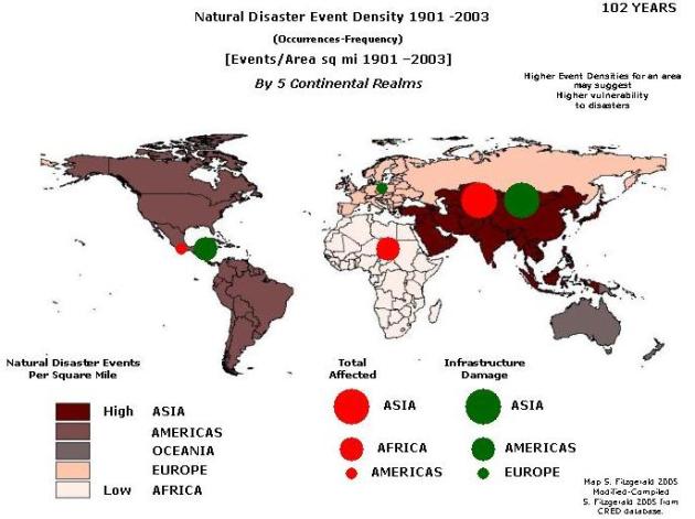
The Most Disaster-Prone Regions Of The Planet. I stumbled upon this paper, showing southern Asia as having the highest frequency of disasters, mostly weather-related. The risk is nearly as high over The Americas, significantly lower over Europe and northern Asia (Russia), lowest over Africa.
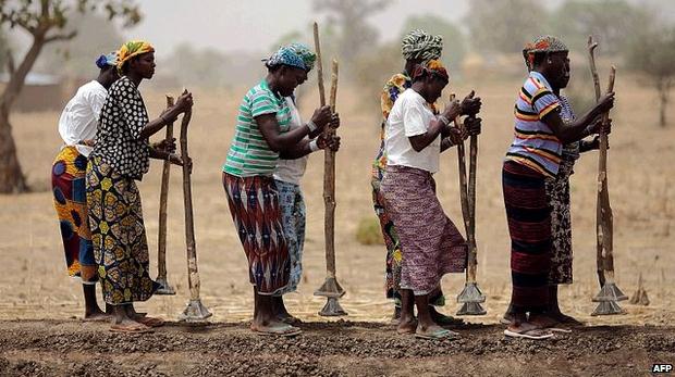
Farming Needs "Climate-Smart" Revolution, Says Report. The BBC has the details: "Major changes are needed in agriculture and food consumption around the world if future generations are to be adequately fed, a major report warns. Farming must intensify sustainably, cut waste and reduce greenhouse gas emissions from farms, it says. The Commission on Sustainable Agriculture and Climate Change spent more than a year assessing evidence from scientists and policymakers. Its final report was released at the Planet Under Pressure conference."
Photo credit: AFP.

How To Fight Food Insecurity, Even In A Changing Climate. Scientific American has the story: "About 800 million people worldwide do not get enough food to eat, while about 1.5 billion are overweight. As the global population expands by an additional 2 billion people by 2050 and climate change alters traditional agricultural areas, scientists and policy makers are racing to figure out how to address both problems. This uneven food landscape is not caused solely by government regulations or farming practices, but stems from many powerful forces—forces that are expected to keep increasing. “Several converging threats—from climate change, population growth and unsustainable use of resources—are steadily intensifying pressure on humanity and world governments to transform the way food is produced, distributed and consumed,” wrote the authors of a new report, published online March 28, from the Commission on Sustainable Agriculture and Climate Change."
Photo credit above: "The Obama administration on Tuesday released its long-delayed proposal to limit greenhouse gas emissions from power plants. (Los Angeles Times / March 27, 2012)."
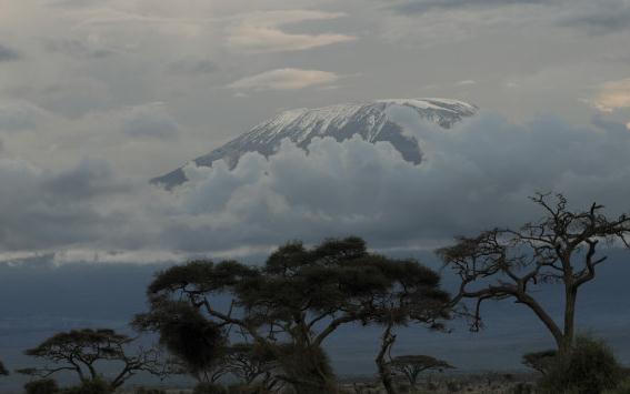
Climate Scientists And Smear Campaigns. Here's a post from CNN and Climate Change: The Next Generation: "Imagine you are sitting in your office simply doing your job and a nasty e-mail pops into your inbox accusing you of being a fraud. You go online and find that some bloggers have written virulent posts about you. That night, you're home with your family watching the news and a talking head is lambasting you by name. Later, a powerful politician demands all your e-mails from your former employer. It sounds surreal. But it all happened to me. What was my offense? I worked on climate change research that indicated the world is a lot warmer today than it was in the past. Because that research caught the public's attention when it was released in 1998, I became one of dozens of climate researchers who have been systematically targeted by a well-funded anti-science campaign."
Photo credit above: "The famed snows of Mt. Kilimanjaro, actually glaciers, are retreating rapidly. Many scientists blame global warming."
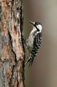
Photo credit above: "In this undated photo provided by Cornell University, an endangered red-cockaded woodpecker clings to a tree. While other birds adjusted their migration ranges northward in response to warming winters, the red-cockaded woodpecker hasn’t moved at all. Cornell researcher Frank La Sorte said on Tuesday, March 27, 2012, they have specialized habitat needs, found only in the sandy longleaf pine forests of 11 southern states. (AP Photo/Cornell University)."