1.3" snowfall so far in March. That, and 8 days above 70 F.
8.2" snowfall last March, as of March 25.
+17.4 F. The first 24 days of March are running more than 17 degrees above average.
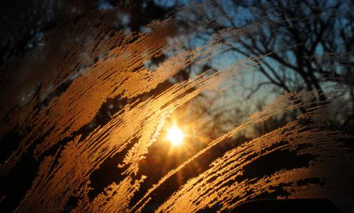
April 29. Mean date of the last 32 F. temperature at MSP International. Details below. Photo: AP.
4 days above 70 so far this March in Duluth, Minnesota. Only 8 other days in March dating back to 1875 have reached the 70 degree mark.
22.3 C. Scotland just set a record for the warmest March on record (72 F). Source:
Mark Vogan.
"
I like to see a man proud of the place in which he lives. I like to see a man live so that his place will be proud of him." - Abraham Lincoln.
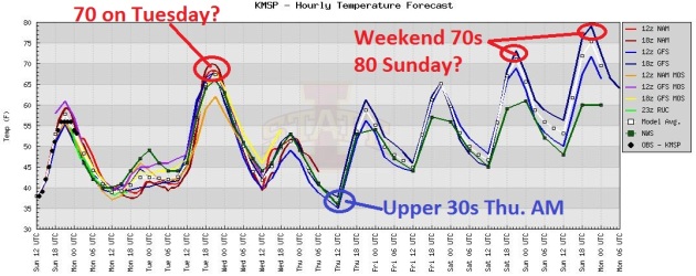
Big Swings. A cool day gives way to a quick, abbreviated surge of warmth Tuesday. 70 is possible tomorrow, followed by a 30-33 degree temperature drop by Thursday morning. A south/southeast breeze resumes late week, the mercury topping 70 Saturday, mid to upper 70s possible Sunday. I wouldn't be surprised to see an 80-degree high close to home by Sunday afternoon.
3 days. The flu virus can live for up to 3 days on paper money. Source:
CBS Sunday Morning. Yuck.
9.1 billion tons of carbon released into the atmosphere in 2010, a new record. After dipping in 2009, due to the worldwide financial recession, carbon increased significantly in 2010, according to the
Global Carbon Project. Source: March edition of BAMS, the Bulletin of the American Meteorological Society.
1,000+ locations set all-time warm weather temperature records between March 13-19.
"Currently, nearly twice as many record hot days as record cold days are being observed both in the United States and Australia, the length of summer heatwaves in western Europe has almost doubled and the frequency of hot days has almost tripled over the period from 1880 to 2005._
"
Extreme weather events over the past decade have increased and were "very likely" caused by manmade global warming, a study in the journal Nature Climate Change said on Sunday." - from a Reuters story below.
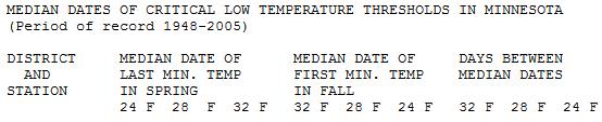
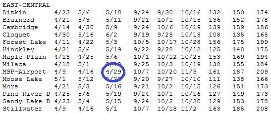
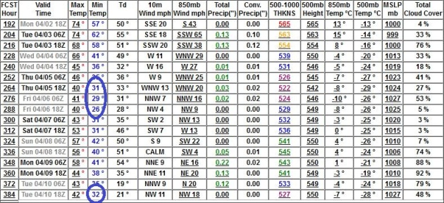
Mean Date Of Last 32 F. Reading? We are rapidly losing track of reality. Data from the
Minnesota Climatology Working Group (1948-2005) shows the average date of the last freezing temperature at KMSP is April 29, more than a month away. The last frost comes as late as May 1 at Stillwater, May 3 at Forest Lake and June 2 at Cloquet. Ouch. The odds of us sneaking through the entire month of April with no more frosty nights is probably less than 1 in 10, even in a record-setting warm March like the one we're currently experiencing. The reason? There's still too much snow on the ground over central and northern Canada, nights long enough to brew up chilly air. In spite of a persistent AO and NAO block, some of that chilly air is destined for Minnesota after April 5 or so. That said, the sun is too high in the sky for it to stay chilly for long.
Minor Relapse. We're not talking snow drifts and wind chill here, but expect a few nights at or just below 32 F around April 6, again April 10. Temperatures may stay just above freezing in and near the downtowns, a better chance of frost in the outlying suburbs. Right now it doesn't look like a widespread freeze - which would be problematic for all those sprouting, budding shrubs and flowers. No significant rain is in sight looking out 2 weeks.
April 10: Closer To "Normal". The models are nudging the core of the jet stream farther south, a little closer to a normal configuration for April. Winds aloft are forecast to be zonal, meaning a Pacific flow, with occasional intrusions of chill air, a few nights close to 32 F. between April 6-11. Expect highs in the 50s, with a few 60s possible - I still don't see any significant precipitation through mid-April.
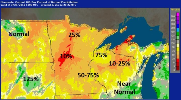
Deepening Rainfall Rut. The map above shows percentage of normal precipitation (rain and melted snow) since September 25, courtesy of
NOAA. The driest part of the state, west central and central Minnesota; only 10 to 25% of normal rainfall amounts have fallen in the last 6 months from Alexandria and Wadena to the Brainerd Lakes area.
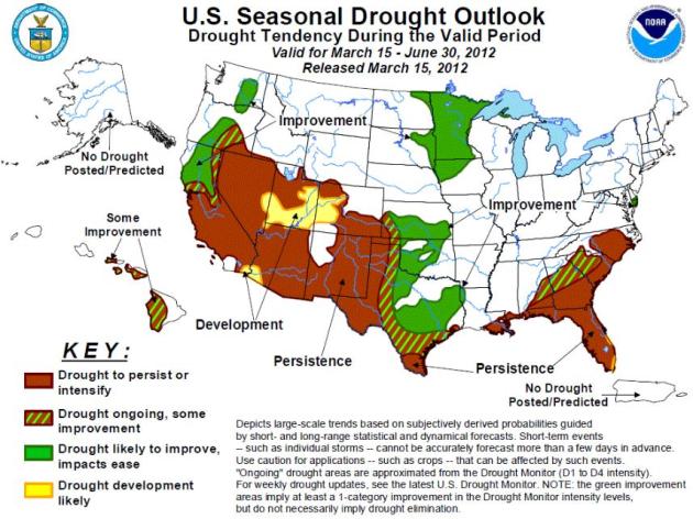
Improving Drought Conditions For Minnesota? I hope long-range forecasters are right, but I don't see any quick rebound in the soil moisture department. The map above is from the
U.S. Drought Portal, which includes current Drought Monitor conditions and a forecast.
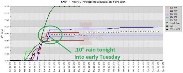
Time To Hook Up The Sprinkler. Tonight's storm will track off well north/west of MSP, pulling 70 degree air as far north as MSP Tuesday afternoon. Models are hinting at .05 to .10" rain tonight and early tomorrow - just enough to settle the dust.
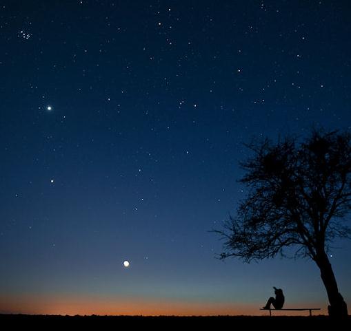
Sunset Sky Show, Again.
Spaceweather.com has detail about the upcoming planetary conjunction which should (weather-permitting) be visible nationwide: "
A month ago, Venus, Jupiter and the crescent Moon aligned beautifully for evening sky watchers around the world. Tonight it's happening again. On March 25th and 26th, the trio will appear side by side in the western sky at sunset. Marek Nikodem photographed the Moon making a beeline for the planets over Szubin, Poland, on March 24th (photo above)."
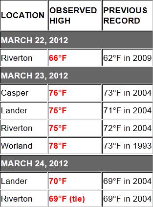
Record Heat Grips The Cowboy State. Have you noticed that the state of Wyoming rarely makes "weather news"? Maybe I'm oblivious (ask my wife) but I can't remember the last time I posted breaking weather from Wyoming. I am not anti-Wyoming; it's just that the weather is usually fairly tame: few reports of tornadoes, hail or flooding. Recently it's been all about the heat, a rash of 70s in recent days, according to the
Wyoming branch of the National Weather Service.
Early Summer Could Come At A Price, UK Ag Meteorologist Cautions. The story from
University of Kentucky College of Agriculture: "
Without looking at the calendar, Kentuckians might easily be fooled into thinking it is early June; but in fact, spring has just begun. After the warmest winter on the record books in the Bluegrass state, spring has sprung very early causing some University of Kentucky Cooperative Extension specialists to gaze eerily back on a similar weather pattern in 2007. “Temperatures soared in the second week of March with highs mostly in the 70s and some locations exceeding 80 degrees,” said Tom Priddy, UK agricultural meteorologist. “Rainfall was frequent; everything is turning green much earlier than usual. You can’t help but think back to 2007.” During that year, spring came early and then a late Easter freeze decimated many horticultural and grain crops throughout the state. So what could growers and gardeners do to prepare for a possible late-season spring freeze? “This pattern is all too familiar to that Easter freeze a few years ago,” said Patsy Wilson, UK viticulture specialist. “The best safeguard for grapes at this point is to hold off on final pruning as late as possible.”
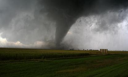
Tornadoes Raise Home Insurance Rates. The story from
stltoday.com: "
The tornadoes that swept through Missouri last year will cost homeowners who didn't feel so much as a stiff breeze. Home insurance rates in Missouri are rising a little more than 5 percent, according to figures from the Missouri Department of Insurance. Illinois state insurance officials wouldn't provide an estimate on how much homeowners premiums may be rising this year. People in the insurance industry call 2011 “the year of the cat,” as in catastrophe. And that partly explains the rising cost of home insurance here. Several tornadoes ripped through St. Louis: one on New Year's Eve of 2010 and then on April 22. Tornadoes laid waste to parts of the mid-South in April, then a massive twister erased much of Joplin in May."
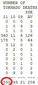
* The article above makes reference to 1,900 tornado deaths in 2011.
SPC reports 550 deaths across the USA last year, the most since 1925. Details below:
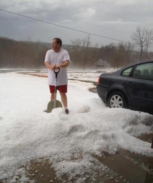
What The Hail? Check out this photo, courtesy of the
Wild About Weather Facebook Page: "
Snowstorm or Hailstorm? Parts of Virginia were covered in inches of hail today, so much hail, that shoveling was necessary! Take a look here of someone shoveling their car out of hail in Franklin County, VA!"
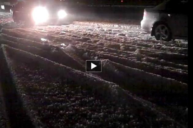
Enough Hail To Shovel And Plow. Here's some amazing video from the
Indianapolis, Indiana NWS Office: "
Brief video from last night's hail storm. Location is I-74 approximately 2 miles west of Highway 9."
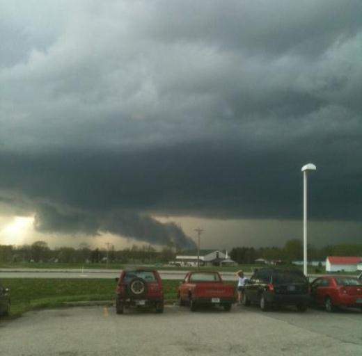
Bloomington, Indiana Wall Cloud. Whenever you see a thunderstorm rotating, and lowering to the ground, take note: it may be about to drop a tornado or funnel. Here's a wild example of a wall cloud, from the
Indianapolis NWS Office: "
A photo of the Wall Cloud and moist inflow south of Bloomington on March 23rd."
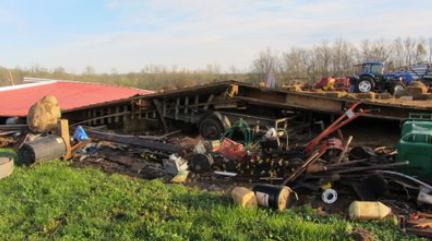
Tornado Damage In Shelby County, Kentucky. From the
Louisville NWS Office: "
A tornado, witnessed by at least three people, touched down in Shelby County on the afternoon of March 23, 2012. The storm destroyed two barns, inflicted structural damage on two others, and snapped or uprooted about two dozen trees."
Photo Of The Day: "Hail Core". Those wisps of white are hints of significant hail reaching the ground. Thanks to Brad Panovich, meteorologist at WCNC-TV, for passing this along via
twitpic.com.
"Ask Paul". Weather-related Q&A.
Hey Paul,
"Will the frost damage/impact the leaves that have sprouted on my crabapple tree... or any tree for that matter? I believe it was 4 years ago when we had a snow event after the trees had close to full size leaves that caused the leaves to fall off & I'm curious if frost has the same impact or was it just the weight of the snow?"
Joe
Joe - I wish I had your (excellent) memory. You are correct. Nearly 6" snow fell on March 31-April 1, 2008 - heavy, wet (gloppy) snow that brought down many tree branches. Frost won't have the same impact on tree limbs, and I doubt we'll see much damage to perennials either. I am concerned about flowers and shrubs that have begun to prematurely blossom. It's a little early for frosty details, but I still suspect 2, maybe 3 nights below 32 in the metro area around April 5-7. The big question: will it be a frost or a freeze? If we dip below 32 F. for a few hours damage may not be so bad, but if the temperature stays below 28 F. for at least 3 or 4 hours (freeze) then all bets are off.
Good Neighbors To Lake Minnetonka.
Tonkatimes.com has an illuminating article about Don and Barbara Shelby's new (very green) home in Excelsior, which is a good read. I read one snarky editorial in the Star Tribune from someone asking the rhetorical question: "how can a $1.25 million home be sustainable?" Good grief - I'm not making excuses for Don, but here's a guy who's trying to do the right thing, set a good example, be a good neighbor, and encourage others to use new technology and common sense to not only reduce their carbon footprint but save money over time. No matter what you do, or say, someone is going to find a way to slam you. I give the Shelbys a lot of credit for opening up their home on the Parade of Homes Tour, and trying to put their money, time and effort where their mouth is. He's paying a premium for being an early adopter, but the features in Don's home will become a defacto standard for all new construction within a few years. Yes, you can make green by going green. O.K. I'm climbing back down off my soapbox. P.S.: Don, you realize that's not a microphone you're holding, right?
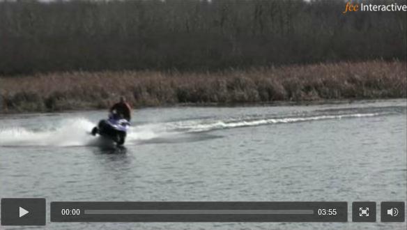
The only way I'd attempt this is with scuba gear and a wet suit. Details (and some wild video) from the
Duluth News Tribune: "
About 30 snowmobilers and several dozen spectators gathered for an informal day of water skipping Saturday on the Rice Lake reservoir north of Duluth. While water skipping at this time of year usually involves riding over water and ice, the “course” was entirely open water on Saturday afternoon under sunny skies. Some participants made a run and circled back to shore; for those who didn’t make it back, a pontoon boat and jet ski were on hand to retrieve the sleds and riders from the shallow water."
Cat Falls 19 Floors, Lands Purrfectly. Strange, but true.
NPR has the details: "
A woman in Boston saw something white fall past her second floor window Wednesday afternoon "and ran to see what it was," according to the Boston Globe. Turns out it was Sugar the cat, who had plunged to the ground from an apartment on the 19th floor. Don't panic, everyone. Sugar is OK. Just some bruising of her lungs, according to the Animal Rescue League of Boston. It helped, according to the Globe, that Sugar landed "on a soft patch of grass and mulch."
"
I know what things are good: friendship and work and conversation. These I shall have." - Rupert Brook
e
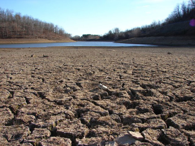
Tornadoes or Drought?
A stark choice, I know. Drought would be more expensive and ultimately damaging to Minnesota's economy. Tornadoes would impact a miniscule percentage of the state, but I don't know anyone who wants a rerun of 2010: Minnesota's wettest year on record, when 145 tornadoes dropped out of a boiling sky - most in the USA.
According to
NOAA's Drought Monitor 96 percent of the state is in a moderate drought, including the metro area, where lake water levels are low. Boaters are a). thrilled, and b). paranoid. A quarter of the state is in severe drought.
Precipitation since September 25 is 50 to 75% of normal for the Twin Cities and southern Minnesota, but only 10-25% of what should have fallen from Alexandria and Wadena to Brainerd.
No big storms are brewing the next 2 weeks, no severe storms either in the short-term, although the ECMWF model is hinting at strong storms next Saturday as warm, humidifed air makes another pass at Minnesota.
Keep shorts and jackets handy. Raw 40s today give way to 70F tomorrow; next weekend looks balmy (again) with highs near or above 70F.
Is that it for winter? Nope. No accumulating snow is brewing, but a beefy cold front is still on track around April 8. Some plants may freeze their buds off. We shouldn't be too shocked: the average date of the last 32F at KMSP? April 29.
Uh oh.
"This is a beautiful planet and not at all fragile. Earth can withstand significant volcanic eruptions, tectonic cataclysms and ice ages. But this canny, intelligent, prolific, and extremely self-centered human creature had proven himself capable of more destruction of life than Mother Nature herself....We've got to be stopped." - Michael L. Fischer, "Harper's", July 1990
Climate Stories...
Link Builds Between Weather Extremes And Warming. The story from
Reuters: "
Extreme weather events over the past decade have increased and were "very likely" caused by manmade global warming, a study in the journal Nature Climate Change said on Sunday. Scientists at Germany's Potsdam Institute for Climate Research used physics, statistical analysis and computer simulations to link extreme rainfall and heat waves to global warming. The link between warming and storms was less clear. "It is very likely that several of the unprecedented extremes of the past decade would not have occurred without anthropogenic global warming," said the study. The past decade was probably the warmest globally for at least a millennium. Last year was the eleventh hottest on record, the World Meteorological Organization said on Friday."
 EcoAlert: New Evidence Links Earth's Extreme Weather To Human-Caused Global Warming
. Another angle on the same research study from
The Daily Galaxy: "
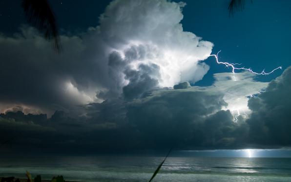
The question is whether these weather extremes are coincidental or a result of climate change," says Dim Coumou, lead author of the article. "Global warming can generally not be proven to cause individual extreme events – but in the sum of events the link to climate change becomes clear." This is what his analysis of data and published studies shows. "It is not a question of yes or no, but a question of probabilities," Coumou explains. The recent high incidence of weather records is no longer normal, he says. "It´s like a game with loaded dice," says Coumou. "A six can appear every now and then, and you never know when it happens. But now it appears much more often, because we have changed the dice." The past week illustrates this: between March 13th and 19th alone, historical heat records were exceeded in more than a thousand places in North America." Photo: "Restless Skies".
 Fears Of 3C Global Warming By 2050
. An excerpt from a story at
Google News: "
The models showed that average world temperatures are on course to rise by between 1.4C and 3C given mid-range greenhouse gas emissions. According to the findings, the world is very likely to cross the critical "two degrees barrier" at some point this century if emissions continue unabated. Experts believe warming of 2C above pre-industrial levels could trigger runaway climate change that cannot be reversed. Almost 10,000 climate simulations were run using volunteers' home computers. The project, climateprediction.net, was part of the BBC Climate Change Experiment."
 Study: Global Temperatures Cloud Rise 5 Degrees By 2050
. An update from
USA Today: "
As the USA simmers through its hottest March on record — with more than 6,000 record high temperatures already set this month — a new study released Sunday shows that average global temperatures could climb 2.5 to 5.4 degrees by 2050 if greenhouse gas emissions continue unabated. The study findings are based on the results of 10,000 computer model simulations of future weather overseen by researchers at Oxford University in the United Kingdom. "These are the first results to suggest that the higher warming scenario could be plausible," says study lead author Dan Rowlands of Oxford. It is a faster rate of warming than most other models predict." Photo: Tony Talbot/AP, USA Today.
Both Coasts Watch Closely As San Francisco Faces Erosion. Here's an excerpt of a story from
The New York Times (subscription may be required to read full text): ".....
The question facing at least eight local, state and federal agencies boils down to this: With California officials expectingclimate change to raise sea levels here by 14 inches by 2050, should herculean efforts be made to preserve the beach, the pipe and the plant, or should the community simply bow to nature? “We are in some ways the tip of the spear for this issue,” said Benjamin Grant, a city planner who is leading a study of the problem for the nonprofit San Francisco Planning and Urban Research Association, or SPUR. Mr. Grant describes the beach’s south end as “an erosion hot spot.” But, he said, all coastal communities will have to grapple with rising seas. A disruptive rate of sea-level rise is one of the most daunting potential consequences of climate change."
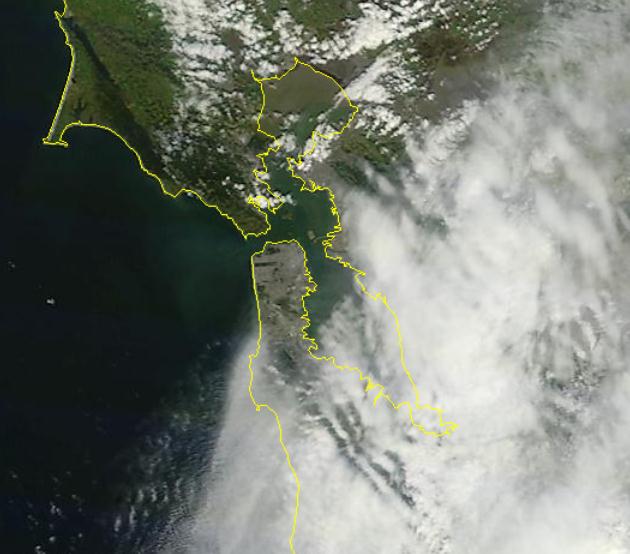
* 250 meter resolution satellite image taken March 22, courtesy of NASA's
MODIS "Terra" satellite and the University of Wisconsin.