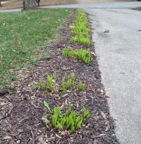
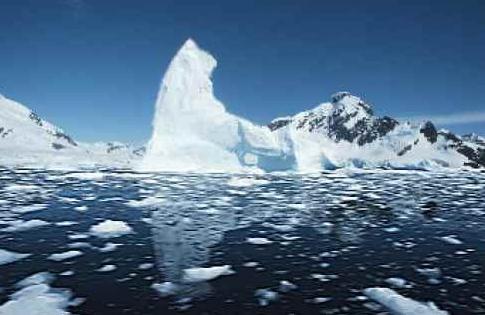
 March: Going Out Like A...Hot Dish?
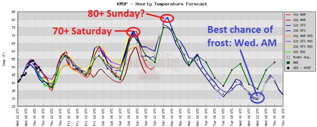
 I couldn't think of a warm-weather mammal in time. I'm tired. This is the best I can do. After a couple more cool days a well-timed warm front arrives for the weekend, low to mid 70s Saturday, a good chance we'll wind up in the 80s on Sunday, before a big temperature tumble next week.
 Frost Looks More Likely
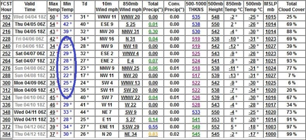
. We may go from mid 80s Sunday to a chance of frost by the end of next week, the GFS still hinting at 3 or 4 nights at or below freezing between April 6-10. No, we're not quite out of the woods just yet. But wait, there's more!

 A Tale Of 3 Seasons: All In The Span Of 72 Hours...?
 The NAM
model prints out a snowy stripe of slush from the Minnesota Arrowhead into northern Michigan and western New York - possibly enough sloppy, wet snow to shovel and plow. Lovely.
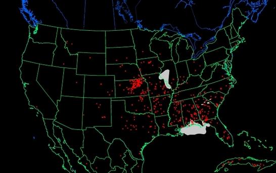
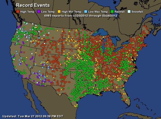 Running Out Of Dots
. Somewhere down there is a map of the United States (of severe weather). This is a
Ham Weather map showing 1 week's worth of records. Red dots: record highs. Yellow dots:
record warm nighttime lows. Blue dots:
record cold highs, purple dots:
record cold lows, and green dots: record 24 hour daily rainfall amounts. 6,985 records in 7 days. I've never seen anything like it:
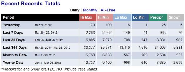
| Total Records: | 6985 |
| Rainfall: | 1050 |
| Snowfall: | 68 |
| High Temp: | 2615 |
| Low Temp: | 82 |
| Low Max Temp: | 154 |
| High Min Temp: | 3016 |
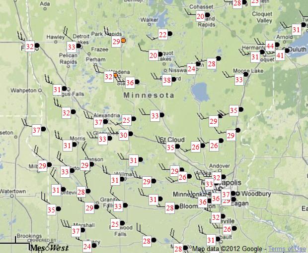
57 mph wind gust reported at 4:05pm Tuesday at Hanley Falls, Minnesota (Yellow Medicine County). Source: MnDOT
Big temperature extremes = big winds. On Tuesday winds at MSP gusted to mph. The greater the swing in temperature over a short period of time, the faster winds have to blow to keep the atmosphere in equilibrium. With temperatures careening from upper 30s to 80 (Sunday) expect plenty of wind as we sail into April. 6 pm Tuesday wind gusts courtesy of
MesoWest.
NOAA has a county-by-county list of Tuesday's peak wind gusts.
3.3:1. In the last 365 days U.S. high temperature records outpace low temperature records by a ratio of 3.3 to 1. Source: NOAA NCDC. Details below.
66.3 F. Sioux City, Iowa has recorded an average high temperature of 66.3 F. so far in March. Not only would this be a record for March - if trends continue through March 31, but if this was the average high for April, it would be the 16th warmest April on record! Source: NWS.
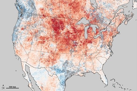
"
Planalytics' Bernhardt said this could be the warmest March since weather data started being tracked 117 years ago." - from a Yahoo Finance story below. Temperature anomaly image above courtesy of
Capital Weather Gang, NASA.
"
On Wednesday, about 170 small wildfires were still burning on about 300 acres across the state of Wisconsin, which is now entirely snow free -- a rarity this early in the year. "Weather in Wisconsin is kind of crazy these days," said Catherine Koele, the state's Department of Natural Resources wildfire prevention specialist." - from a Reuters story, details below. March 27 map above courtesy of
NOAA's FireDetect link.
8.6% of the continuous U.S. currently covered by snow. This time last year: 35.4%
bit.ly/GUAkfK . Source:
NOAA.
| Area Covered By Snow: | 8.6% |
| Area Covered Last Month: | 29.6% |
"
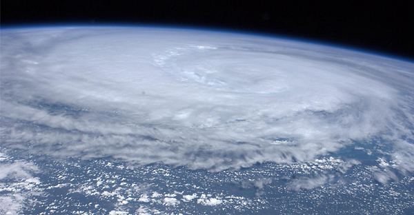
Our goal is to break this myth," Read said, referring to taping. "It does not protect your windows. At best, it's an inconvenience. At worst, some people have the illusion that they're safe ... and people can get severely hurt." - AP story below on why hurricane officials are advising coastal residents
not to tape up their windows before a hurricane. Hurricane Katia image above courtesy of NASA.
90% of projected warming, worldwide, has been predicted by climate science to go into the oceans (heat content of oceans continues to rise, according to peer-reviewed analysis). Source: Joe Romm. Think Progress.
"
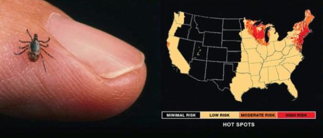
Reports of Lyme disease have risen seven-fold in Maine and four-fold in Wisconsin over the last decade. Warmer temperatures are expanding the range and persistence of the disease." (map:
American Lyme Disease Foundation)
"
Since 1996, bark beetles have laid waste to 65,000 square miles of U.S. forest – an area roughly the size of Washington State. One reason: winters are often not cold enough to control their numbers." - from an article at the Environmental Defense Fund below.
"
Global warming can generally not be proven to cause individual extreme events -- but in the sum of events the link to climate change becomes clear." - from a Science Daily article below.
“
We are on the cusp of some big changes,” said Steffen. “We can ... cap temperature rise at two degrees, or cross the threshold beyond which the system shifts to a much hotter state.” - from an article at iolscietech.com.
The United States of Weather Records. NOAA's
NCDC has a terrific site that keeps a running tally of weather records, by state, or for the entire USA. Here is a summary:
Last 365 Days:
129,404 weather records in the last year, since March 27, 2011.
68,948 warm weather records, nationwide, in the last year.
20,620 cold weather records, nationwide, the last year.
* 3.3 times more warm weather records than cold records in the last 365 days.
31,770 weather records since January 1, 2012
March Data:
13,393 warm weather records since March 1, 2012
832 cold weather records, nationwide, since March 1, 2012
* 16 times more warm weather records than cold weather records since March 1, 2012.
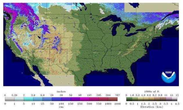
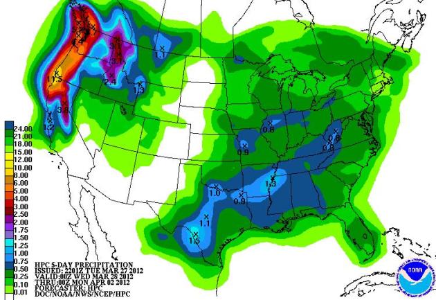 Pacific Northwest Drenching
. Yes, that's an 11" bulls-eye over southwestern Oregon, a series of strong Pacific storms lashing the west coast with flooding rains and heavy mountain snows. Up to 1" rain is possible from San Antonio and Dallas eastward to Memphis over the next 5 days. Map courtesy of
NOAA.
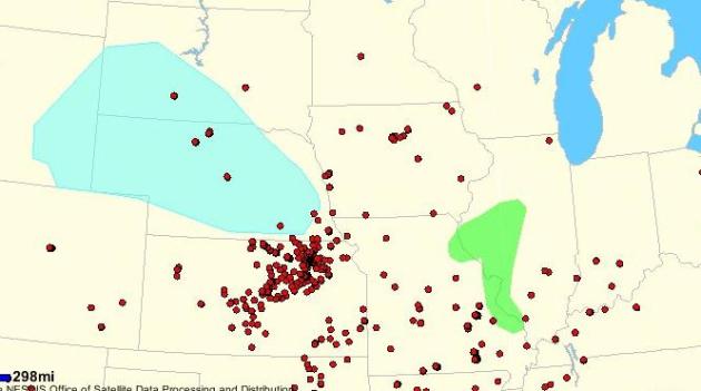
Warm Weather Stoking Fire Concerns In Northern U.S. We haven't had any soaking rainstorms recently, and that's causing growing concern for not only agriculture and lake water levels, but a risk of spring brushfires.
Reuters has more details: "
The unseasonably warm weather giving many residents an early taste of summer has raised the danger of wildfires in some northern parts of the country where such fires are unusual, officials warned on Wednesday. In Wisconsin, where several grassfires over the past week claimed hundreds of acres and were blamed for two deaths, the Department of Natural Resources issued a high and very high fire danger alert for half the state. The National Weather Service also issued fire weather watch warnings on Wednesday for parts of North Dakota and Montana. Forecasters said the current warm weather and low humidity, combined with the unusually mild and dry winter, had turned vegetation in many areas into kindling that easily could be set alight by lightning strikes or human carelessness." Map above showing real-time wildfires and brushfires courtesy of
NOAA.
Stores Getting A Boost From Warm Weather. Yes, many retailers are euphoric about our early spring - it's getting more people into America's stores and malls, as reported by AP and
Yahoo Finance: "
NEW YORK (AP) -- Though painful for retailers early on, this winter's warm weather later turned into a boon. Sales of cold-weather gear were well below expectations, leaving stores with piles of boots and coats and snow shovels to mark down and push out in December and January. But warm-weather items started selling well in February, long before they usually do. The latest retail sales data from market research firm Planalytics Inc., whose clients include major discounters, department stores and clothing chains, show brisk sales of shorts, live plants and other springtime goods from Feb. 1 through Tuesday. Planalytics uses weather patterns to advise stores what they should buy to sell to customers."
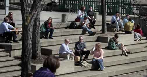
Photo credit above: "
Dozens of workers, students, shoppers and others took advantage of the unseasonably warm weather to enjoy the noon hour at Peavey Plaza in downtown Minneapolis. The Plaza is in the heart of downtown. Credit: Jim Gehr, Star Tribune."
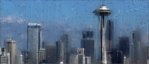
5.18" rain so far in March in Seattle, the 10th wettest March since 1945. Seattle photo credit
here.
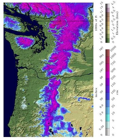
All-Time Snowfall Records Fall Across Western Oregon And Southwest Washington State. Some amazing numbers from Steve Pierce at
The Columbian: "
Many cities across Western Oregon and Southwest Washington are setting all-time cold and snowfall records for this late in the season. Since Tuesday night, the Willamette Valley has been blanketed with anywhere from 2" to 9" of snow from Vancouver, WA. south to Eugene, Oregon. Since Tuesday evening, many all-time March snowfall and temperature records have been broken up and down the Willamette Valley at airport locations. Portland, Salem, Eugene and Vancouver, WA. airports all set new coldest daytime high temperature records on Wednesday in addition to setting new all-time records for the heaviest snowfall this late in the season. Eugene, Oregon easily broke their maximum daily precipitation record for Wednesday with 1.92 inches which equated to a record setting 7.5" of snowfall on Wednesday." Map credit:
NOAA NOHRSC.
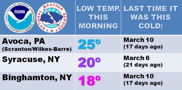
Some Plants In The Northeast Froze Their Buds Off Tuesday Morning. Graphic above courtesy of the Binghampton, New York office of the National Weather Service.
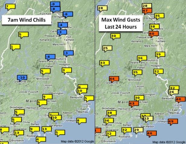
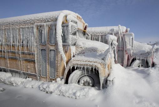
Winter Bites Back. Here are some Tuesday morning wind chill readings, from the
Caribou, Maine office of the NWS: "
We’ve gone from mid-summer warmth to mid-winter cold! Here are the 7am wind chills this morning and the maximum wind gusts for the last 24 hours. Wind chills have dropped below 0F over the north and winds have been gusting over 40 mph over some areas, especially in open areas and on hilltops. Fire danger is high today as well, with a red flag warning in effect for many areas."
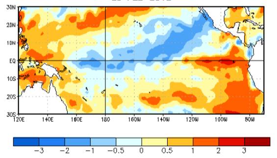
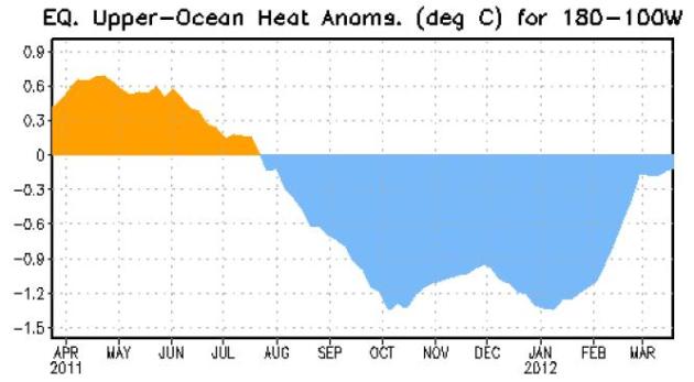
La Nina Weakens, Set To Impact California And U.S. Weather Until May. Here's an update on the (weakening) cooling ENSO phase from the
Northridge Examiner: "
The La Niña anomaly that caused widespread droughts and above average temperatures throughout winter has begun to weaken. Data from the NOAA’s buoy system has indicated sea surface temperatures with weakening anomalies in the average temperature readings. These conditions, in addition to other atmospheric occurrences, reflect the decline of La Niña conditions in the equatorial Pacific, though their atmospheric reverberations will affect U.S. weather through the season: California experiences La Niña conditions in spring as abnormally dry with the possibility for below-average temperatures.
From La Nina To El Nino? How much time do you have?
Here are all the details you'd ever want to know about this ENSO phase transition, courtesy of NOAA.
Message via
"
Paul, Please help. We need colder weather in South Dakota. The Turkeys have already started to STRUT bcuz of the warm weather. Turkey season doesn't start til April 14th." - Miles Riker
You're in luck! After a balmy weekend (80 on Sunday?) we cool off the first week of April; I see highs mostly in the 50s, a few nights below freezing from April 4-12. Expect cooler, more seasonably April weather. Good luck out there!
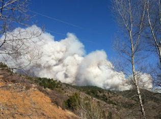
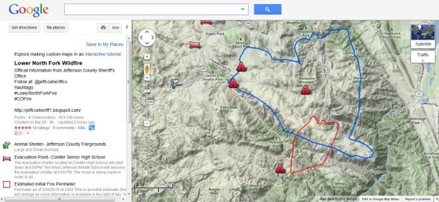
Jefferson County Colorado Wildfire Update. Here is some additional information on the fire burning in the Denver area, from the
Jefferson County Sheriff's Office: "
25 people sheltered overnight at the Conifer High School Evacuation Point. The fire is estimated to be over 3050 acres. Over 450 firefighters are expected to be working the fire by the end of the day. A Lead Plane has been ordered from Ogden, Utah A Heavy Tanker and a Heavy Heli-Tanker has been ordered. Deployment of air support is dependent on weather conditions."
Tracking The Colorado Blaze. Google has a very
useful link, with resources and evacuation information for the Lower North Fork Wildfire in Jefferson County, Colorado.
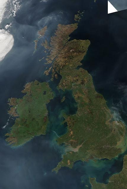
Scotland Sets 3 All-Time Warm Weather Records. Mark Vogan's outstanding
weather blog has the details: "
Although not just as extreme of the US in terms of margin from old record to new record, in my opinion, it is harder for us to see this type of record-breaking weather than in the US simply because we don't typically get EXTREMES here due to various reasons. However, the tell tale signs have been with us since early last December when we were basically the stormiest place or one of the stormiest places on the planet with every other day seeing severe gale-force winds, torrential rains and damage. On Christmas day, Northern Ireland saw it's warmest Christmas on record while Scotland and the UK fell shy by less than 1C. We also fell just shy of the February record for Scotland by less than 1C, but this month, mother nature says, ya know what, I think it's time to set a record and not once, not twice but three times! Old Record: 22.2C recorded at Gordon Castle in 1957, Sunday's new record: 22.8C at Fyvie Castle, Monday's new record 23.2C at Cromdale, today's new record: at least 23.6C at Aboyne!"
* satellite image courtesy of NASA MODIS and Mark Dunphy.
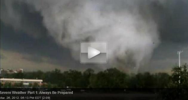
Severe Weather Part 1: Always Be Prepared.
WYTV-TV has some amazing video and timely tips for all of us: "
This is Severe Weather Awareness Week in the state of Ohio and through Friday, the My Valley Weather team will be giving safety tips and important information to keep you safe during storms. The series begins by focusing on the perfect conditions for severe weather and why it's important to always be prepared. "The peak season for tornadoes is usually April, May and even into June," said My Valley Weather chief meteorologist Don Guthrie. "Time of day, they occur mainly during the peak heating hours of the afternoon. That would be between noon and say 9 p.m., but they can also happen after that," said My Valley Weather forecaster Ryan Halicki. "Unfortunately that can happen just about any time you have a very strong thunderstorm as long as you have the necessary ingredients," Guthrie said."
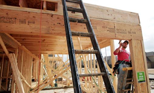
Guest Commentary: Strong Building Codes Can Mitigate Tornado Damage. Here's an Op-Ed from the
Detroit Free Press that seems to have a lot of merit: "...
One of the smartest and most effective steps Congress could take would be to provide states with incentives to adopt statewide, model building codes. Strong building codes are widely embraced in the emergency management community as being our best first line of defense against tornadoes, hurricanes, earthquakes, flooding and other weather-induced disasters. When homes and commercial buildings are constructed to the model codes issued by the International Code Council, it is simply harder for the wind and water to knock them down. According to an Institute for Building Sciences study commissioned by the Federal Emergency Management Agency, for every dollar invested in pre-storm mitigation such as promoting the statewide adoption of strong building codes, the nation reaps four dollars in benefits."
Photo credit above: "
Jorge Tobar works on the framing of a house in Collierville, Tn. for John Worley Jr. Builder Inc. Tuesday, March 13, 2012. Worley expects the price tag to go up on his homes about 2% once new building codes that are designed to improve earthquake resistance and energy efficiency go into effect for all new designs submitted after March 1st. (AP Photo/The Commercial Appeal, Mike Brown)."
Consider A Severe Weather Checklist. KSTP.com has some terrific information about steps you should consider taking before the storms hit: "
To stay safe in spring storms, you can prepare a severe weather kit that doesn’t have to break your budget. Here are some items to consider including and what they might cost you:
Essentials
- Battery-operated radio (approximately $20 and up)
- Flashlight (approximately $5)
- Extra batteries (approximately $2)
- Do not include candles, which cause more fires after a disaster than anything else
Groceries (approximately $50)
- 3 gallons/person, minimum, in a food-grade, plastic container
- Additional water for sanitation"
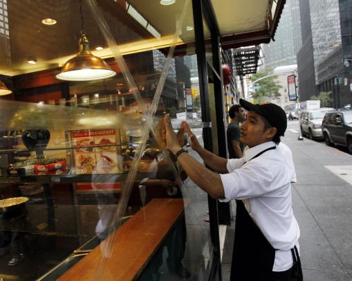
Hurricane Officials: No More Tape For Windows. A story from
AP: "
ORLANDO, Fla. (AP) — Officials with the National Hurricane Center had a message Tuesday for residents living in hurricane-prone areas: Don't tape your windows. Center officials are joining with a consumer advocate group at the National Hurricane Conference in Orlando, Fla. this week to encourage residents to skip taping their windows when a hurricane is heading their way. They believe it leads to a false sense of security and actually increases danger. Instead, residents should use proven methods such as hurricane shutters or impact-resistant windows, Bill Read, director of the National Hurricane Center, told hundreds of meteorologists and emergency management officials at the weeklong conference. Attendees are going to seminars on insurance policy and emergency communications as well as hawking hurricane-related wares such as canned food and building-hardening materials."
Photo credit: "
Marcos Dorates tapes up a window of a restaurant in preparation for Hurricane Irene in New York, on Saturday, Aug. 27, 2011. (AP Photo/Mike Groll)."
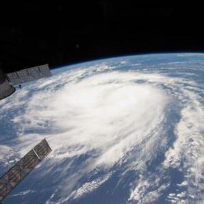
A Lesson In Preparedness From Hurricane Irene. Some good information in this post from
ezinearticles.com: "
Hurricane Irene struck us with a vengeance August 28, 2011. We were all warned about high winds and prepared for that. We were woefully unprepared for what actually happened which was a flood of devastating proportions. Loss of power for days and isolation by washed out roads in that disaster prompted us to rethink what we might need to survive another natural disaster. Survivalists take disaster planning to the extreme of preparing for a very long term devastating event, the extent of which we may not even be able to imagine yet. Those plans take lots of money and considerable time to execute. Most people just can't dedicate that much to emergency planning. Yet, we all should be prepared on some level for emergencies. This article gives some basic advice for what to consider and how to prepare for an emergency that everyone can follow." Hurricane Irene image above courtesy of NASA.
March Is Flood-Awarness Month In Iowa. Some helpful tips from
WOWT-TV: "
Many Iowans in high risk floodplain areas still lack insurance. Although the National Weather Service is forecasting a generally low risk of widespread flooding this year, eight of the 14 Presidential Disaster Declaration since 2007 were for flooding. Iowans have experienced major floods during late summer, and heavy rains and flash floods can occur at any time....There are more than 53,000 homes, businesses and other structures in Iowa’s high-risk floodplain areas. However, only 9,636 structures (18 percent) in those areas are covered by flood insurance. Of the 18,923 flood insurance policies in Iowa, about half are for structures located outside mapped floodplains."
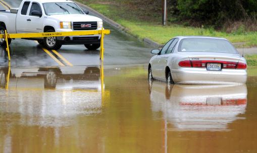
Photo credit: "
A car sits on a flooded street after severe weather passed through the area in Troy, Ala., Friday, March 23, 2012. The National Weather Service says heavy rains are causing flooding in parts of west Alabama. (AP Photo/The Troy Messenger, Robbyn Brooks)."
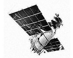
Soviet Satellite To Fall To Earth. Great. One more thing to keep me up at night. Details from
Space Daily: "
Meteor-1, the Soviet Union's first fully operational weather satellite, will on Monday night re-enter the Earth's atmosphere after more than four decades in orbit, the web site of the U.S. Strategic Command said. The Meteor satellite series was developed in the Soviet Union during the sixties. On March 26, 1969, a Vostok rocket launched Meteor -1, the very first version of the Soviet Meteor satellite network, into orbit. The satellite terminated operations in July 1970, according to NASA information."
Photo credit above: "
Russia is stopping the mission of the Express-AM4 telecommunication satellite, which was launched in August. At about 17.32 Moscow time on Sunday, the flight control center will descend the satellite from its orbit, and it will fall into the ocean near the Hawaii Islands. To avoid any collisions, the region will be closed for ships and planes for the time of the operation. "
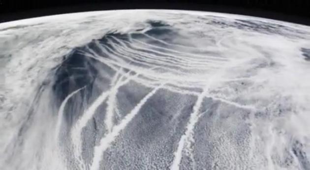
Man-Made Weather. Every day we inadvertenly alter the weather, from seeding clouds with pollutants to the "urban heat island effect" to jet contrails spreading out into cirrus, keeping us a few degrees cooler by day and milder at night. Here's a spectacular example of ships "seeding" clouds over the Pacific, courtesy of
NASA: "
NASA's MODIS satellite instrument reveals how air pollution may alter clouds, affecting global temperatures. This narrated visualization illustrates the effect by showing how ship exhaust leaves brights cloud trails in clean ocean air. The ship tracks themselves are too small to affect global temperatures, but they help us understand how larger pollution sources might change clouds on a bigger scale."
"Ask Paul". Weather-related Q&A.
Paul,
"You are one of the smartest most rational people I've come across and the only person with a blog that I have ever followed. Please take 5 minutes to watch this.. Is there any possible rational explanation here? I don’t have access to these weather maps, but maybe you do and can verify. Please let me know if the link doesn't work."
Thanks,
Tyler Dove

Thanks Tyler - appreciate the compliment, but my wife would beg to differ - but I'm very happy you're tuning into the blog. Why do I spend 4-5 hours/day? I find the process vaguely therapeutic, it helps me uncover (and remember) nuggets I can then use on the air for various clients, and I'm genuinely concerned about climate change and what it means for Minnesota, my kids, and yours. Now, to your question: I watched the video and I suspect what you're seeing are, in fact, brushfires - which are often best illuminated by a rising or setting sun. Nothing else (of this world) would explain those plumes. Keep in mind fires are most likely to kick off late in the afternoon, when humidity levels are lowest, and winds are (usually) the strongest, as high-level winds mix down to the surface. That's my guess:
brushfires. The NOAA map above shows all the active fires as of Tuesday evening around the USA. Much of the nation is still very dry - and prone to fire. We need a few (soaking) storms to reduce the overall fire risk.
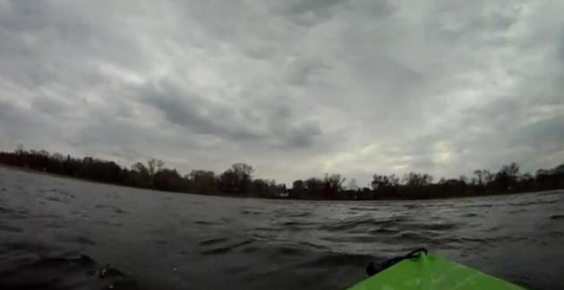
"Kayak-Surfing"?? Why not. Just mash a few sports together to create something new, and fun. I can't believe I'm talking about kayaking and surfing on March 28. Broadcast Weather meteorologist Aaron Shaffer has the details and
YouTube clip. He's going a little nuts with his new toy, a "GoPro" video camera that straps to his helmet: "
Took out the kayak on a day when the waves were churning - and it made for an interesting time! In this video I am heading *into* the wind - but I made great time heading back to the landing with 30mph wind at my back!"
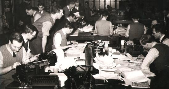
Even Old Institutions Are Acting Like New Media. Here's a fascinating article on the "appification" of legacy media from one of my favorite publications (web, app and dead-tree edition),
The Atlantic: "
It is no revelation that the leading media brands have joined in recent years what is an extraordinary process of expansion beyond their original platforms to accommodate the temptations -- or more explicitly, the needs -- of the digital age. Running down a list of the biggest names in traditional news (a selection of my favorites among them), including the New York Times, NPR, CBS (60 Minutes Overtime), PBS News-Hour, C-SPAN, the Economist, and The Atlantic, you realize that every one of them has made substantial commitments in multiple channels of distribution: blogs, videos, galleries, RSS feeds, podcasts, widgets, mobile and tablet apps. So far it is probably still the case that the overall financial investments involved have been greater than the revenue return." Photo credit above: Reuters.
Gulf Oil Spill: Coral Death "Definitely" Linked To BP Oil Spill. Here's an update from
The Huffington Post: "
NEW ORLEANS (AP) — After months of laboratory work, scientists say they can definitively finger oil from BP's blown-out well as the culprit for the slow death of a once brightly colored deep-sea coral community in the Gulf of Mexico that is now brown and dull. In a study published Monday, scientists say meticulous chemical analysis of samples taken in late 2010 proves that oil from BP PLC's out-of-control Macondo well devastated corals living about 7 miles southwest of the well. The coral community is located over an area roughly the size of half a football field nearly a mile below the Gulf's surface." Photo credit: AP.
The Universe In Infrared: Flood Of Galaxy Views To Hit Internet This Year. There are some mind-boggling pics of galaxies I've never seen before - yes, I'm a geek, but I find this stuff fascinating.
Space.com has the story: "A catalog of detailed infrared portraits of more than 200 galaxies will be released publicly for the first time later this year, giving people access to exciting views of the cosmos. The pictures were made from data collected by NASA's Spitzer Space Telescope, which is designed to study objects in the universe in infrared light. Some of the
images that will be included in the new directory will be unveiled at the U.K.-Germany National Astronomy Meeting, which is being held this week in Manchester, England.
Photo credit above: "
A mid-infrared image of M91 as seen by the Spitzer Space Telescope. M91 is the protype example of a barred spiral galaxy. Although the spiral arms are easily seen in mid-infrared light, the bar is only faintly visible. Credit: G.J. Bendou/JBCA/NASA."
Scientists Record Nighttime Fish Farts. Hey, I don't make the headlines, ok? But the public has a right to know.
Neatorama.com has the fishy details: "
Scientists studying fish distribution using an underwater robot have picked up a strange sound under the sea. It's barely audible, cricket-like noises. What could it be? Autonomous gliders are a relatively new technology for studying oceanography over large time and space scales. We integrated a hydrophone into the aft cowling of a glider and used it in a 1 wk, shelf-scale deployment on the West Florida Shelf to detect and map fish sounds in the ocean over a large spatial scale."
 Eating Lot's Of Chocolate Helps People Stay Thin, Study Shows
. O.K. Counterintuitive, but who am I to argue with scientists. Pass the (dark) chocolate, please.
CBS News reports: "
What's the best way to stay thin? A new study finds it's exercising and eating a healthy diet full of - chocolate? The study found that people who frequently ate chocolate had a lower body mass index (BMI) than people who didn't. Is it time to ditch fat-free for fudge? For the study, published in the March 26 issue of Archives of Internal Medicine, researchers examined more than 1,000 healthy men and women who were free of heart disease, diabetes and cholesterol problems. They were all enrolled in another study that measured the effects of cholesterol-lowering statin drugs, but for this study researchers assigned them questionnaires that gauged how often participants chowed down on chocolate." Photo credit
here.
"Handpresso Auto" Takes Quality Coffee On The Road. It's official - we are a nation of insane people. Hey, I love (and need) coffee as much as the next guy, but if I ever see anyone operating one of these I'm going to pull off to the side of the road and dial 911.
Gizmag.com has the nutty details of what you have to purchase for those rare moments when you're not driving past a Caribou, Dunn Brothers or Starbucks: "
Imagine the convenience of brewing a creamy, steaming cup of espresso right in your car and you'll get a sense for the impetus behind the latest creation from Handpresso. The company has added to its range of mobile espresso machines with the Handpresso Auto, a well-designed in-car gadget which is designed to turn just about anyone into a mobile barista."
Outlook: More "Riffraff"
This changes everything. Most of the nation is afraid of Minnesota, because of our legendary winters. "Is it safe to fly out?" my father asks every.. May. Yes. The snow is only hip-deep, but we can still get around. When word gets out we had a puny, Nashville-like 22 inches of snow and only 3 nights below zero (average is 28) I suspect a paradigm-shift.
Winters are trending warmer, spring is coming earlier, and although I wouldn't bank on a 6-month summer every year, I predict Minnesota companies will have an easier time luring job prospects to the North Woods.
18 warm weather records in the metro this month; the average March temperature a record 48.3F, more than 3 degrees warmer than the previous record in 1910.
So did experts blame 1910 on climate change? No, but CO2 levels were significantly lower, and China wasn't adding one new coal-fired power plant every week.
10 of the 14 warmest years on record, worldwide, have been observed since 1998. 37 years of above-average temperatures, according to NOAA & NASA.
Keep jackets and shorts handy; a better hair-day today as winds ease. We hit 70 Saturday, 80 possible Sunday, a hint of frost late next week.
Showers are expected Thursday night; a bigger storm brewing early next week. We need about 2-4" rain.
* photo above: AP.
"
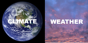
Weather and climate are flip-sides of the same coin."
Climate Stories...
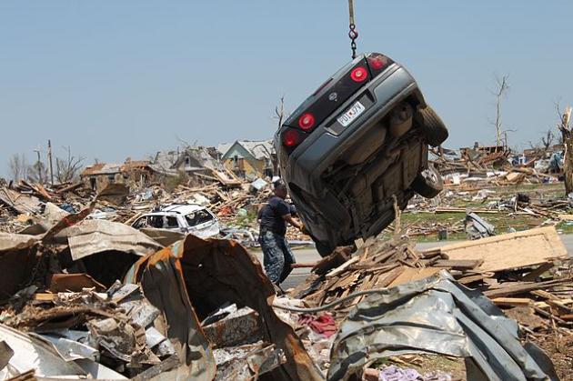
Climate Change Loads Disaster Dice. The story from
Discovery News: "
From floods in Pakistan to droughts in China and tornadoes in the U.S., the past few years have seen numerous deadly extreme weather events. A team of climate scientists at the Potsdam Institute for Climate Impact Research in Germany laid the blame for the increased frequency of disasters on a warming climate. "The question is whether these weather extremes are coincidental or a result of climate change," said Dim Coumou, lead author of the Potsdam Institute's analysis, in a press release. "Global warming can generally not be proven to cause individual extreme events -– but in the sum of events the link to climate change becomes clear." "It is not a question of yes or no, but a question of probabilities," said Coumou."
Photo credit above: "
Photo: Chief Yeoman Mike Shea helps a crane operator move a wrecked vehicle during tornado clean-up efforts in Joplin, Mo. Credit: Wikimedia Commons, U.S. Navy photo by Lt. j.g. Ryan Sullivan/Released."
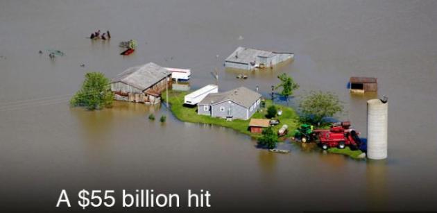
A $55 Billion Hit. From the
Environmental Defense Fund: "
In 2011, 14 separate weather disasters each cost the U.S. $1 billion or more in damages. Hurricane Irene alone caused 45 deaths and $7.3 billion in damages across nine Northeast states. Total U.S. claims: $55 billion, roughly equivalent to the budget of the Department of Homeland Security. "
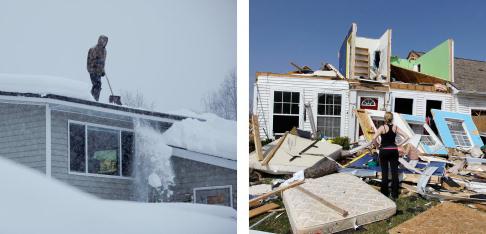
Extreme Weather Of Last Decade Part Of A Larger Pattern Linked To Global Warming. Science Daily has the story; here's an excerpt: "
ScienceDaily (Mar. 25, 2012) — The past decade has been one of unprecedented weather extremes. Scientists of the Potsdam Institute for Climate Impact Research (PIK) in Germany argue that the high incidence of extremes is not merely accidental. From the many single events a pattern emerges. At least for extreme rainfall and heat waves the link with human-caused global warming is clear, the scientists show in a new analysis of scientific evidence in the journal Nature Climate Change. Less clear is the link between warming and storms, despite the observed increase in the intensity of hurricanes."
Photo credit above: "
In this combination photo, Doug Hamrick shovels snow off of his family's roof in Anchorage, Alaska on Thursday, Jan. 12, 2012, left, and Katie Cramer looks over the front of her destroyed house in Dexter, Mich. on Friday, March 16, 2012 after a tornado touched down on Thursday night. America's weather is stuck on extreme. Nearly 11 feet of snow has fallen on Anchorage this winter, where the city has already hauled away 250,000 tons of snow. Yet not much snow dropped on the Lower 48. The first three months of the year have seen twice the normal number of tornadoes, killing 55 people. And 36 states broke or tied daily high temperature records on Thursday, March 15, 2012. (AP Photo/Loren Holmes, Carlos Osorio)."
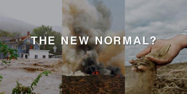
8 Global Warming Effects That May Surprise You. Here are a few surprising side-effects of a warmer, wetter, stormier atmosphere, from EDF, the
Environmental Defense Fund: "
We’ve all heard about record floods, scorching wildfires and devastating heat waves. Extreme weather has become "the new normal." But here are some immediate – and worrisome – impacts from climate change that you might not have heard about."
Climate Change: World Is Reaching Tipping Point. Here's a post from
iolscietech.com: "
As emissions grow, scientists say the world is close to reaching thresholds beyond which the effects on the global climate will be irreversible, such as the melting of polar ice sheets and loss of rainforests. “This is the critical decade. If we don't get the curves turned around this decade we will cross those lines,” said Will Steffen, executive director of the Australian National University's climate change institute, speaking at a conference in London. Despite this sense of urgency, a new global climate treaty forcing the world's biggest polluters, such as the United States and China, to curb emissions will only be agreed on by 2015 - to enter into force in 2020."
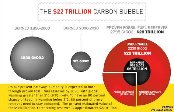 The $22 Trillion Carbon Bubble.
 This may be one of the more important stories you read about motives behind ongoing climate denial. There's a very real concern that regulations will be put into place to limit how much of the remaining carbon reserves in the USA can be burned, because of concerns about pollution (mainly greenhouse gases contributed to warming). If all the coal, oil and gas is burned - it would almost certainly lead to a worst-case scenario, a possible 6-10 F. warming trend by the end of 2100, which would have a draconian impact on not only weather, but seas levels, water supplies and desertification, worldwide.
Think Progress has the details: "
The global economy is riding on a financial bubble that dwarfs the subprime crisis — a $22 trillion carbon bubble. On our present pathway, humanity is expected to burn through proven fossil fuel reserves by 2050, making global warming greater than 5°C (9°F) likely and civilizationally catastrophic effects irreversible. To have an 80 percent chance of keeping warming below 2°C, 80 percent of proven reserves need to stay unburned. The present estimated value of these civilization-threatening reserves is approximately $22 trillion."
Taming Uncertainty In Climate Prediction. Here's an excerpt of an article at
physorg.com: "
The word "uncertain" always seems to appear when describing Earth and atmospheric systems in numerical models. Trying to represent complexity through computer simulations has limitations, not the least of which is a lack of sufficient computing power. Consider trying to model human body systems with numbers. Humans come in all shapes, sizes, ages, locations, and temperaments. It's the same with atmospheric systems. Getting a handle on the systems' uncertainties, to effectively and efficiently represent current weather and climate systems in a computer model, paves the way for scientists to apply those same techniques to predict the future climate changes. Sound predictions will give planners the tools to forecast the probability of extreme weather and climate events."
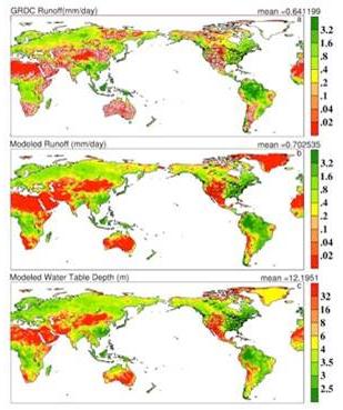
Computer simulation credit above:
"GRDC (Global Runoff Data Center) runoff climatology (observation), (b) the modeled runoff, and (c) the modeled water table depth. These simulations are the first to model global water table (or groundwater level) dynamics, and the first time to represent groundwater dynamics in Global Climate Models (GCMs), which are powerful tools for projecting climate change." Courtesy:
University of Texas.
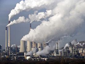
New Limit Pending On Emissions. An update from
The New York Times: "
After months of delay, the Obama administration is about to unveil the first federal standards to explicitly limit greenhouse-gas emissions from new electric power plants — one of the chief sources of carbon dioxide emissions linked to climate change. According to people briefed by the Environmental Protection Agency, all existing plants — including the 300 or so coal-fired power plants that now release the highest level of these emissions and yet-to-be-built plants that have already received E.P.A. permits — will be grandfathered in at current levels, meaning they are exempt from the new proposed rule."
Cities On The Front Line Of Climate Change. Here's another story from
physorg.com: "
More than half of the world's population of seven billion currently lives in cities and by 2050, this is expected to increase to 70 percent, or around 6.4 billion, according to UN figures. More than 60 percent of the increase will occur in Asian cities -- and nearly half of the growth will happen in cities that currently have 500,000 inhabitants or fewer. It means that cities will face unparalleled challenges when climate change starts to bite, scientists said Monday at a meeting on the world's environment ahead of the June 20-22 summit."
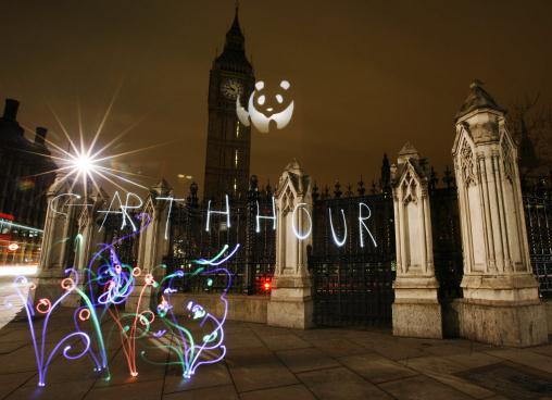
Photo credit above: ** TIME EXPOSURE WITH LIGHT PAINTING ** "
In this time exposure, photographer Michael Bosanko, not seen, uses a combination of coloured-gel lights to 'paint' the words 'EARTH HOUR' ,plants and flowers and the WWF logo as he is back-dropped by the landmark St. Stephens tower of the Houses of Parliament in central London, Saturday March 28, 2009. From the Great Pyramids to the Acropolis and the Las Vegas strip, nearly 4,000 cities and towns in 88 countries joined in the (WWF) World Wildlife Fund-sponsored event, a time zone-by-time zone plan to dim nonessential lights between 8:30 p.m. and 9:30 p.m local time to raise awareness about climate change and the threat from rising greenhouse gas emissions. WWF's logo at upper center was exposed with lighting through a cutout. (AP Photo/Lefteris Pitarakis)."