*66 F. high in the Twin Cities on Saturday, a new record for March 10. Warmest since
October 12, 2011 (69 F.)
59 F. old record high, set in 1878.
9" snow on the ground in the Twin Cities on this date last year. Source:
NOAA.
32 F. lows? I don't see any more sub-freezing temperatures for the Twin Cities looking out 2-3 weeks.
 Check Your Clocks
. Did you remember to spring forward one hour? There's always one clock in the house that will get you into trouble. Yes, we lost a precious hour of sleep, but look at the bright side, literally:
sunset this evening is 7:14 pm.
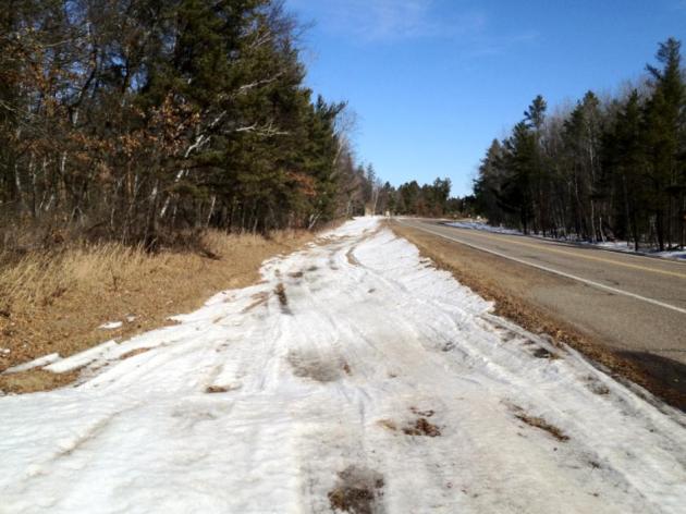
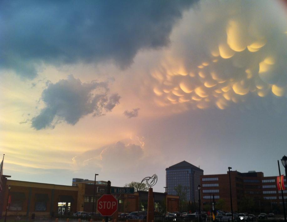
Tough Times For Snowmobilers. I snapped this pic (on my iPhone 4S) Saturday afternoon outside of Nisswa, just north of Brainerd. There is about 2-4" slushy snow left in wooded areas, but precious little elsewhere. A very rough ride for ditch-riding. Kind of sums up our Kansas City Winter.
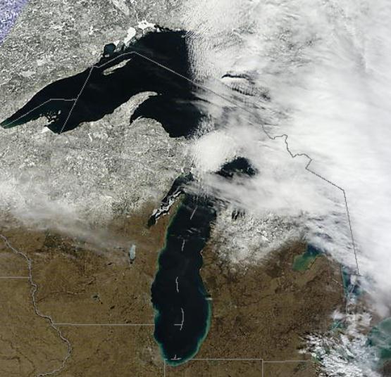
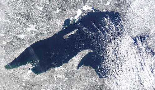
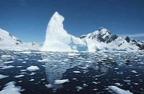
5 percent of the Great Lakes surface froze over this winter, the least since satellite photos first were taken from space.
"
The average amount of ice covering the Great Lakes declined 71 percent over the past 40 winters, with Lake Superior ice down 79 percent, according to a report published by the American Meteorological Society." - from a story at The Duluth News Tribune, details below. NASA "
Modis" satellite image above courtesy of the University of Wisconsin.
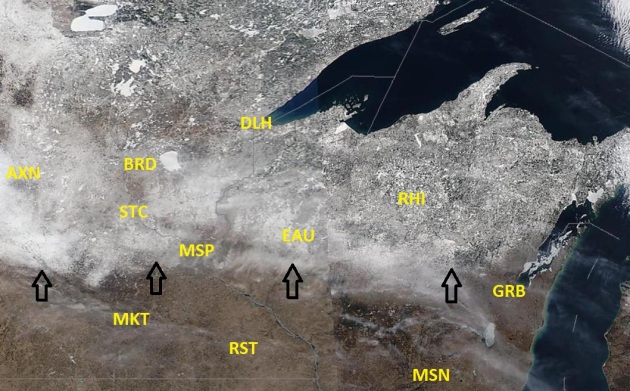
Rapid Snow Melt. With highs soaring into the 60s through next week snow isn't long for central and northern Minnesota. Saturday's high-res NASA "
MODIS" satellite showed the southern edge of the snowcover line running from Granite Falls to Hutchinson to the northern suburbs of the Twin Cities. The southern third of Minnesota and southern half of Wisconsin is essentially snow-free. Tough times for snow lovers. Yes, winter is pretty much over.
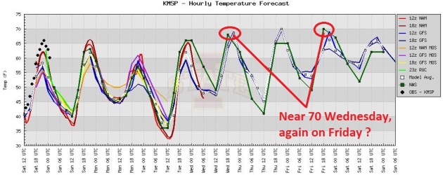
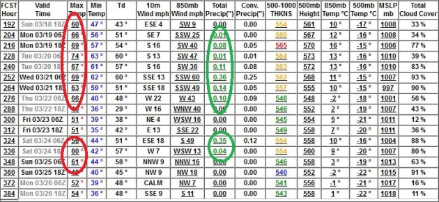
We've Only Just Begun...To Warm Up. With all due deference to The Carpenters (sorry) Saturday was just a taste of what's to come. The ECMWF Outlook is above; you'll be reassured to know those predicted highs are in Centigrade. 70 is possible by Wednesday, likely next weekend, mid 70s by Monday, March 19th? Yes, we seem to have skipped 2 months. Minor meteorological technicality.
Meteorological Time-Warp: Welcome To The Second Week of May. The ECMWF tipped me off to 70 a few days ago, now all the other models are catching up - every run nudges the mercury ever higher this week; the best chance of hitting 70 Wednesday, again Friday. Long-range guidance is hinting at mid-70s in about 8-9 days. Amazing.
"
Though we travel the world over to find the beautiful, we must carry it with us or we find it not." - Ralph Waldo Emerson
"
The Defense Department, the Intelligence Community, and the Department of Homeland Security are closely studying the effects of climate change, particularly how it will impact our security." - from a Consumer Energy Report below. Photo image courtesy of treehugger.com.
"
The number of images out there means advertisers have a much more difficult time breaking through the clutter, causing the content to be much more violent and sexualized to get consumers' attention," said Occidental University associate professor Caroline Heldman, who specializes in media, gender and race."
"
It may sound like some tired feminist rant to anyone who grew up with a smartphone. In fact, women are objectified more than ever, experts say, thanks to a constant barrage of images from all forms of media, many of them connecting products to a pair of breasts and a coy smile." - from an article below on how media warps concepts of beauty. Photo courtesy of
mediabistro.com.
Report: Great Lakes Ice Cover Has Decreased 71% Since 1973. Some startling statistics from the
Duluth News Tribune: "
The average amount of ice covering the Great Lakes declined 71 percent over the past 40 winters, with Lake Superior ice down 79 percent, according to a report published by the American Meteorological Society. “There was a significant downward trend in ice coverage from 1973 to the present for all of the lakes,’’ states the study appearing in the society’s Journal of Climate. Researchers used Coast Guard reports and satellite photographs taken from 1973 to 2010 to determine the ice coverage of all the lakes, with Lake Ontario ice dropping 88 percent while ice in Lake St. Clair (between Lake Huron and Lake Erie) diminished just 37 percent."
Photo credit above: "
A satellite photo of Lake Superior and the region taken Friday afternoon shows little ice on the lake. (Photo by National Oceanic and Atmospheric Association / Space Science and Engineering Center, University of Wisconsin-Madison)."
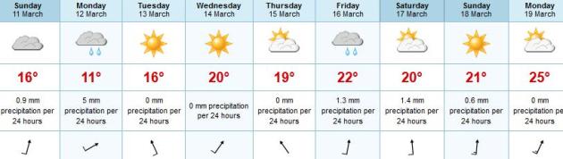
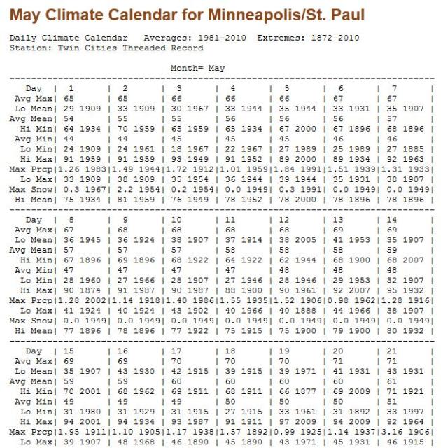
Comparisons To May? Not An Exaggeration. I know - meteorologists are prone to fits of hype and wild exaggeration. But when we talk about how the weather this week will be more like late April, even May, it's not stretching the truth one bit. Above is the "Climate Calendar" for the Twin Cities in May, courtesy of the
Minnesota Climatology Working Group. Friday's predicted high for MSP is 71, the average high for May 20
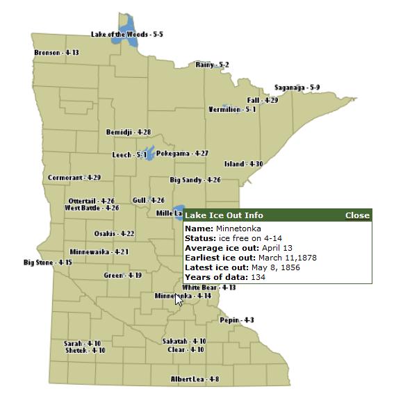 An Early Ice-Out?
 According to the
Minnesota DNR the average date for ice-out on Lake Minnetonka is April 13. Why do I think it'll be earlier this year? My gut (nausea?) is the last week of March, at the rate we're going, with highs (consistently) in the 60s looking out the next 1-2 weeks, and some light rain early tomorrow. For the record, the average ice-out on White Bear Lake is April 12, on Lake Mille Lacs it's April 24.
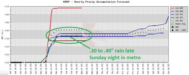
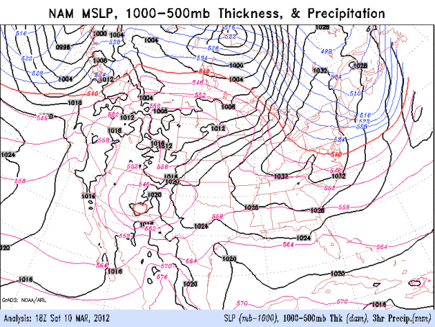
A Little Moisture Would Be Nice. With the rain-snow line shoved north of Winnipeg there's no way we're going to see any frozen precipitation anytime soon. Models are hinting at .30 to .40" of rain. The official local NWS prediction is in green - about .35" late tonight into Monday morning.
Tournament Puddles. A southern storm will push a pinwheel of (rain) showers into Minnesota late tonight, up to a third of an inch of rain possible early Monday. Meanwhile, a strong cold frontal passage will sweep down the west coast, whipping up high winds, heavy rains, and mountain snows. NAM model courtesy of NOAA.
A "Warm Bias" Into Late March. No arctic fronts in sight, at least not yet. Considering the sun is now as high in the sky as it was in late September, it's going to be hard to get truly bitter air into Minnesota. A few more days in the 30s and 40s before spring sticks around (for good?) Probably, but I don't see it looking out 2 weeks.
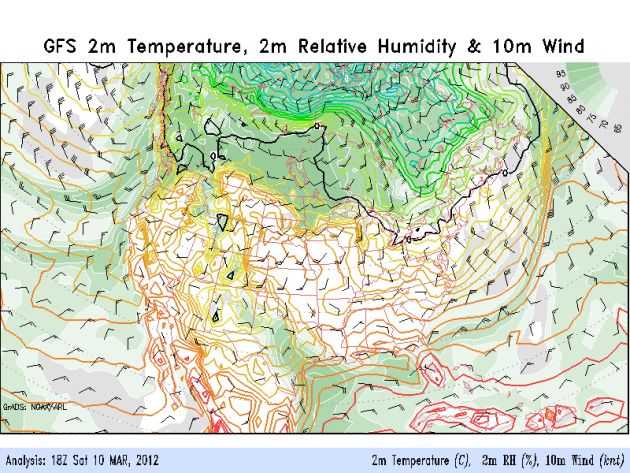
Ignore The Calendar. It's May. I honestly can't remember a March like this. Sure, we've seen years with (brief) surges of warmth, a few days in the 60s or 70s in mid-March. But to be consistently in the 60s, even some 70s, for several weeks in a row in mid and late March? Now that's a bit unusual. The GFS temperature outlook (above) shows consistently warm temperatures for the next 8 days; temperatures running 20-35 degrees above average. A bit surreal.
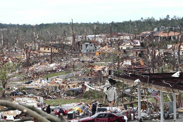
Tornado facts
--They may strike quickly, with little or no warning.
--They may appear nearly transparent until dust and debris are picked up or a cloud forms in the funnel.
--The average tornado moves southwest to northeast, but tornadoes have been known to move in any direction.
--The average forward speed of a tornado is 30 mph, but may vary from stationary to 70 mph.
--Tornadoes can accompany tropical storms and hurricanes as they move onto land.
--Waterspouts are tornadoes that form over water.
--Tornadoes are most frequently reported east of the Rocky Mountains during spring and summer months.
--Peak tornado season in the southern states is March through May.
--Tornadoes are most likely to occur between 3 p.m. and 9 p.m., but can occur at any time.
* Source: FEMA,
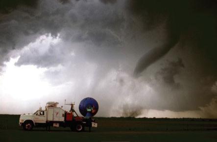
blueridgenow.com. Photo above of NSSL "Doppler on Wheels."
Planning For Tornadoes Increases Chance Of Survival. Some good tips and timely reminders from
BlueRidgeNow.com: "
If a tornado is likely, the National Weather Service will issue a warning for the area, and individuals should seek shelter. The safest place is in an interior bathroom or closet and away from windows, according to the NWS. If outdoors, find shelter in a low area, such as a ditch or culvert, to avoid the flying debris that causes most injuries and deaths. If in a car, abandon the vehicle and seek shelter in a ditch or sturdy building. Do not try to outrun a tornado or hide under an overpass. Most tornado deaths and injuries happen outdoors, in automobiles and mobile homes."
 Do You Want To Be A Storm Spotter?
 SKYWARN is always looking for weather enthusiasts who want to help track and communicate severe weather. Doppler radar is great, "dual-polarization" Doppler is another big step forward, but there's still no substitute for "ground truth", for having eyes on the ground, confirming a supercell is producing large hail, wall clouds, funnels or an actual tornado. This is especially critical at distances of more than 50-75 miles away from a NWS Doppler installation, where it's impossible for meteorologists to see what's happening at or near ground level, due to curvature of the Earth.
Newschannel9.com in Chattanooga has more details: "
We hear a lot about "storm spotters," but many of our viewers don't know who they are or how they relay vital reports of severe weather. It's a growing Skywarn network of people trained to identify severe weather and help the National Weather Service know when warnings should be issued. "Spotters become more or less the eyes and ears of the weather service," according to Bob Gault, the public information officer for Bradley County Auxiliary Communications Service. Gault is a certified weather spotter who you may also recognize as the spokesman for the Bradley County Sheriff's Office. Spotters like Gault are volunteers and when severe weather threatens they keep their eyes on the skies looking for trouble. They are trained by National Weather Service meteorologists and have to take a course at least once every two years."
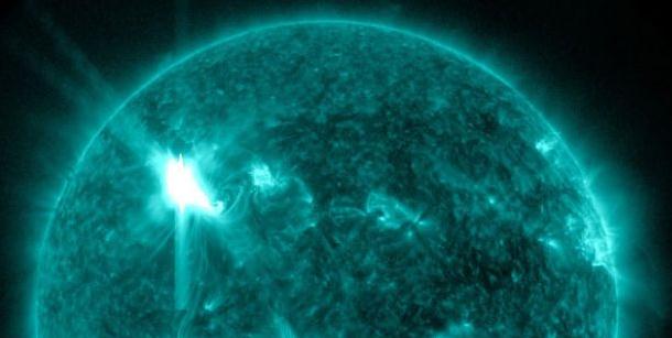
Strong Solar Flares Still Shooting Out From Active Spot On Sun.
Fox News has more details: "The sun is continuing its active streak this week, firing off another solar flare late Thursday (March 8) from the same region that produced this week's strong solar storm. An M6.3-class
solar flare — a mid-range eruption — spewed from the surface of the sun last night at 10:53 p.m. EST (0353 GMT March 9), according to an alert from the Space Weather Prediction Center, a joint operation by the National Oceanic and
Atmospheric Administration (NOAA) and the National Weather Service.
* this may increase the odds of seeing the Aurora Borealis, the magical "Northern Lights" in the coming nights. No way to predict in advance, but it may be worth a try.
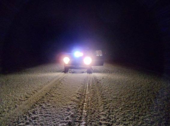
Hail And High Water. This photo was snapped just east of San Angelo, Texas late Friday. More from the San Angelo, Texas NWS office: "
Small hail was a common sight across West Central Texas last night and this morning. Freezing levels are very low and surface temperatures are in the mid to upper 30s, preventing the hail from melting very quickly. Some areas received fairly significant accumulations of hail. The attached picture was sent to the National Weather Service from one of our dedicated storm spotters near Wall."
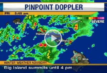
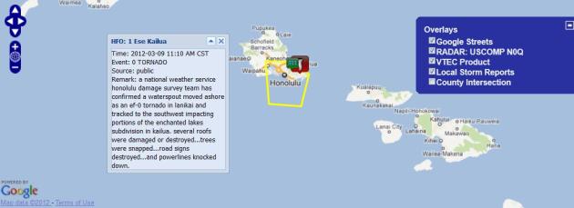
Funnel Clouds Over Hawaii? Now I've officially seen everything. Details from the Honolulu NWS Office:
PRELIMINARY LOCAL STORM REPORT
NATIONAL WEATHER SERVICE HONOLULU HI
356 PM HST FRI MAR 09 2012
..TIME... ...EVENT... ...CITY LOCATION... ...LAT.LON...
..DATE... ....MAG.... ..COUNTY LOCATION..ST.. ...SOURCE....
..REMARKS..
0710 AM TORNADO 1 ESE KAILUA 21.40N 157.72W
03/09/2012 OAHU IN HONOLULU HI PUBLIC
A NATIONAL WEATHER SERVICE HONOLULU DAMAGE SURVEY TEAM
HAS CONFIRMED A WATERSPOUT MOVED ASHORE AS AN EF-0
TORNADO IN LANIKAI AND TRACKED TO THE SOUTHWEST IMPACTING
PORTIONS OF THE ENCHANTED LAKES SUBDIVISION IN KAILUA.
SEVERAL ROOFS WERE DAMAGED OR DESTROYED...TREES WERE
SNAPPED...ROAD SIGNS DESTROYED...AND POWERLINES KNOCKED
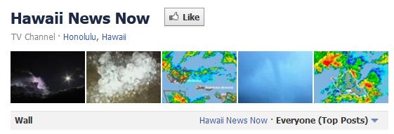
DOWN.Latest Storm Content From Hawaii. Click here to see a steady stream of (amazing) pics and video clips of the severe storms and flooding rains wracking Hawaii, courtesy of Hawaii News Now's
Facebook Page.
Hawaiian Weather Woes Bring Landslides, Hail.
KITV-TV has more details on the (highly unusual) storms plaguing Hawaii: "
HONOLULU -- Parts of Hawaii continue to get drenched by thunderstorms and heavy rains that has caused large hail, closed schools, sewage spills and ruined vacations.Oahu is under a flash flood warning until 10 a.m. Friday. A flash flood watch is in effect until Saturday for Maui, Molokai, Lanai, Oahu, Kauai and Niihau.Kauai County officials warned the public to stay off roads because of thunder, lightning and flooding. The Kauai bus will not be offering service north of Hanamaulu until further notice. A landslide was reported near the Kauai Marriott, blocking a lane of traffic.
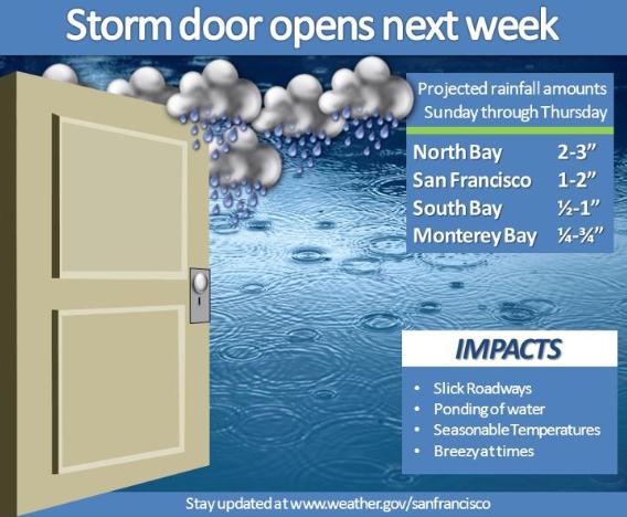
A Very Stormy Pattern For The West Coast. Here are details from the San Francisco Bay Area NWS office: "
An active weather pattern this week is poised to produce one of the wettest week of the season. A series of low pressure systems will move across the area bringing periods of rain, seasonal temperatures and breezy conditions. The higher rainfall will occur north of San Francisco while the southern extent of the rainfall is still in question, so stay tuned for future bulletins."
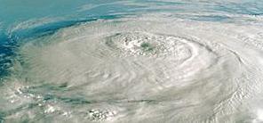
NHC Implements New Hurricane Categorization Scale. Some tweaks to the Saffir Simpson scale for measuring hurricane intensity/threat?
AccuWeather.com has more details: "
The Saffir-Simpson Hurricane Wind Scale (SSHWS) is a 1 to 5 categorization based on a hurricane's intensity at an indicated time, according to the National Hurricane Center (NHC). The scale is undergoing a minor modification in 2012 to resolve "awkwardness associated with conversions among the various units used for wind speed in advisory products." Essentially, the new modification is to help clarify categorization of wind speed measurements based on miles per hour (mph), kilometers per hour (km/h) and knots. There is an inherent uncertainty when estimating wind speeds for tropical cyclones. Generally, wind speeds are rounded because it's unrealistic to identify exact wind speeds. So, these numbers are rounded to the nearest "5." For example, 132 mph would be rounded to 130 mph, while 137 knots would be rounded to 140 knots." Hurricane photo courtesy of NASA.
Paul's Links. Favorite weather links:
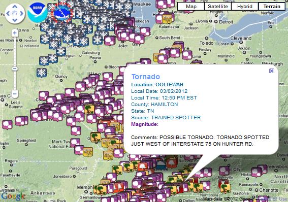
1).
Experimental Storm Reports. This is a terrific link from NOAA, showing storm reports on an interactive, zoom-able Google map. You can see today's severe weather reports, or any day in the past. Map above is from March 1-3, showing the historic outbreak of severe storms and tornadoes in the Ohio Valley.
2).
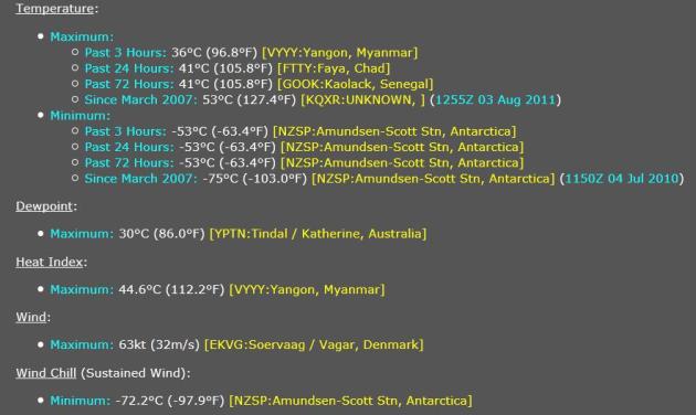
Extreme And Weird Weather Of The World. Coolwx.com has a variety of useful, constantly updating maps. At 7 pm Saturday evening the hottest reporting station on earth was Yangon, Myanmar, reporting a whopping 96.8 F. Factoring in dew point it felt like 112.2 F. Ouch. Peak winds could be found at Vagar, Denmark (roughly 70 mph). You'll be the hit of your next party. Or not.
3).
IEM Cow. NWS Storm-Based Warning Verification. This is a powerful application, created by the Iowa Environmental Mesonet, down at the Iowa State University Department of Agronomy. Every NWS warning from each office is numbered and catalogues, so you can specify a location, a date, and then call up all warning information, along with actual storm reports. More details: "Data presented here is
unofficial and should be used for educational purposes only. This application allows you to view warnings and storm reports issued by a Weather Forecast Office (WFO) for a period of time of your choice. The application attempts to automatically provide verification numbers for the warnings issued. " IEM Cow map above is from March 9, showing a rare (weak) tornado in Hawaii.
4).
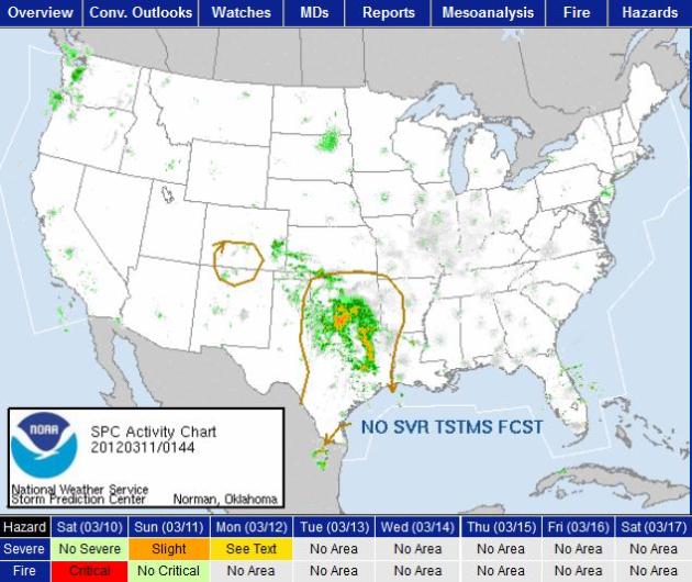
SPC: Storm Prediction Center. A division of NOAA, meteorologists at SPC in Norman, Oklahoma monitor the skies above America, searching for conditions ripe for severe storms, specifically high winds, hail and tornadoes. This is a necessary first stop for any weather enthusiast interested in pin-pointing which areas of the USA are primed for severe weather. SPC issues watches for a 3-8 hour period, meaning conditions are favorable for severe weather. Local NWS offices ultimately issue any warnings for specific counties or portions of counties, an average warning lasts 20-45 minutes. Check the "Convective Outlook" tab to see if there is a slight/moderate/high risk nearby. A moderate risk usually implies a significant risk of tornadoes later in the day - that's the threshhold we look at when deciding which states are most prone to tornadic supercell storms.
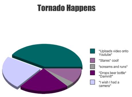
Tornado Happens. Sadly, this may be fairly accurate. Graphic credit
here.
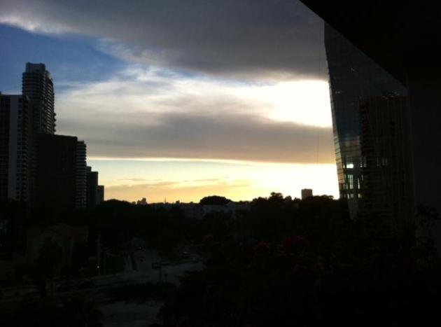
Miami Sunset. Thanks to meteorologist Bay Scroggins for sending in this pic from the Miami area. Showers and T-storms have been sprouting up across the Sunshine State, a stalled front keeping skies unsettled and potentially thundery again today.
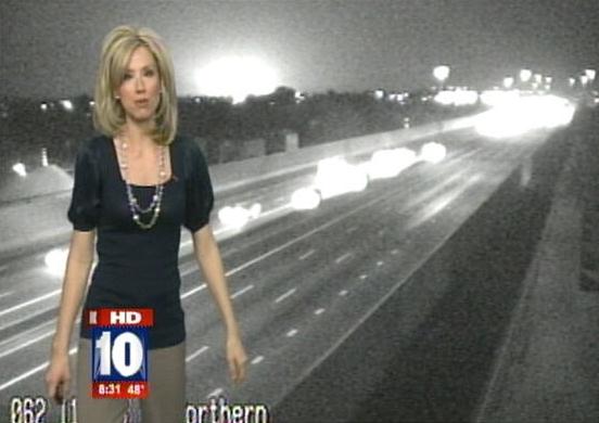
Mysterious Flash Captured During Live Traffic Report In Phoenix. Not a clue what this was - but I thought you might want to see this story from
Science News Blog: "
A large flash was spotted in Phoenix during Andrea Robinson's live 5 am traffic report Thursday morning on Fox 10 News Phoenix. It looks like it could have been a transformer explosion, but the electric utilities serving Phoenix - APS and SRP - told Fox 10 they had no transformer problems in the area. There have also been no reports of an explosion, according to the network. Fox 10 is reaching out to the public for information about the mysterious flash."
Sex, Lies And Media: New Waves Of Activists Challenge Notion Of Beauty. Here's an interesting story from
KVIA-TV in El Paso, Texas: "
Here's the fantasy: A half-naked woman lies across a couch, lips pouty and cleavage prominent as her sultry gaze implores you to buy this bottle of perfume.The reality: Women make up 51% of the United States yet only 17% of seats in the House of Representatives. They're 3% of Fortune 500 CEOs and 7% of directors in the top 250 grossing films.What's the connection? We live in a sexualized society where the gap between fantasy and reality is vast and harmful, director and activist Jennifer Siebel-Newsom says."Women are aspiring to do great things in leadership, yet the glass ceiling is still there because of the way media depict women," Siebel-Newsom said. "It influences our culture and dictates our gender norms and values."Siebel-Newsom's documentary, Miss Representation, is the latest cinematic foray in the movement to challenge portrayals of beauty in "the media," a term used to describe all forms of mass communication, from the internet, TV, film, magazines, radio and advertising."
Photo credit above:
The Beauty Myth.
HDMI Dongle Brings Android To Your "Dumb TV". Here's an interesting story from
Engadget: "
Google TV's looking for a second wind here at CES, but for those of you uninterested in buying a new TV (or a new set-top box, for that matter), here's a little diddy that just might tickle your fancy. Always Innovating is making a triumphant return to Las Vegas with what might be the raddest little gizmo of the show. The simply-titled HDMI Dongle is effectively an entire system on a chip dongle (and yeah, it looks a lot like Roku's Streaming Stick), boasting a Cortex-A9, between 256MB and 1GB of RAM, inbuilt WiFi / Bluetooth, an NFC module and even an accelerometer. The goal here is to convert your completely vanilla HDTV into an internet-connected device; just plug it into your HDMI port, grab the bundled RF remote and start enjoying Android on the big screen."
"
It has become appallingly obvious that our technology has exceeded our humanity." - Albert Einstein
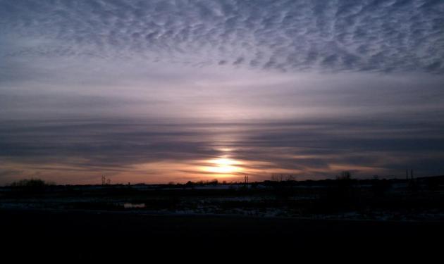
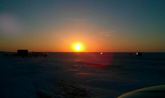
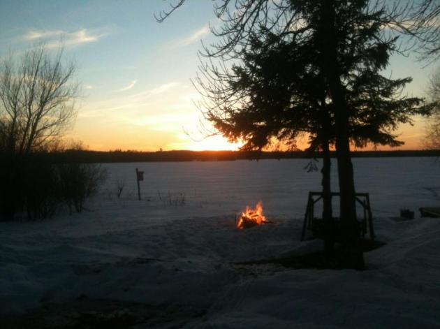
Sun Setting On Winter. Thanks to meteorologist Todd Nelson for passing along this sunset from St. Michael (upper left). Meteorologist Kate Ferrier snapped the photo in the upper right, on Lake Mille Lacs. Stating the obvious:
ice safety is going to be a growing concern over the next 1-2 weeks. Be careful out there.
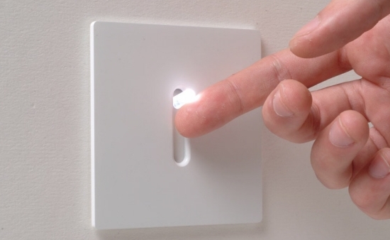
An Early May
It's the atmospheric equivalent of turning on a light switch. 30s and wind chill on a Friday - mid 60s just 24 hours later. Impressive.
I feel almost giddy; an odd mix of euphoira, and a nagging sense of dread.
This.
Is.
Not.
Normal.
Think about it: we just enjoyed the 4th warmest winter on record, in spite of La Nina cooling of the Pacific, which correlates with cold, snowy winters for the northern USA. Right. The American Meteorological Society reports a 71 percent drop in ice on the Great Lakes since 1973. Only 5% ice cover this winter, the least since the satellite record began.
Meanwhile that same La Nina pattern is energizing the jet stream, sparking more tornadoes than usual. The latest SPC count from March 2 is 159. If it holds it would set a new record, eclipsing the "Super Outbreak's" 148 tornadoes in 1974.<p>More 60s on tap today, high clouds dim the sun - forerunners of a sloppy southern storm capable of (rain) showers tonight and Monday.
I'm not exaggerating when I say the weather maps look like May; 70 by late week? Models hint at an inch or more of rain around March 21, but no beefy cold fronts are brewing.
The winter that wasn't..isn't. Hello spring!
"
Thank God men cannot fly, and lay waste the sky as well as the earth." Henry David Thoreau
Climate Stories...
 Fears Of Tornado Catastrophes Due To Global Warming Unfounded.
 There is still considerable debate in meteorological circles about a possible link between a warmer, wetter climate and tornadogenesis. Although warming at northern latitudes may decrease baroclinicity (and subsequent wind shear aloft responsible for spinning up the most violent tornadoes) an increase in instability and higher dew points may provide additional buoyancy, major factors in the formation of tornadoes. In the spirit of debate, underscoring the remaining uncertainty, here's an article from Universe Today: "
The 2012 tornado season got off to a rousing start. Between February 28th and March 3rd, two deadly storm systems developed in the southern United States. The storms spawned numerous tornadoes that together killed at least 52 people. This kind of extreme tornado activity, so early in the year, has fueled fears that global warming will increase the severity and duration of the tornado season. But, scientific studies show that this is not necessarily to be expected. Early tornadoes are not unheard of. For example, on February 29 in 1952, two tornadoes caused severe damage in the south-eastern US. But this year, the number of early tornadoes has been much higher. The National Oceanic and Atmospheric Administration reported that in January of 2012, the tornado total was 95, much higher than the 1991–2010 average of 35."
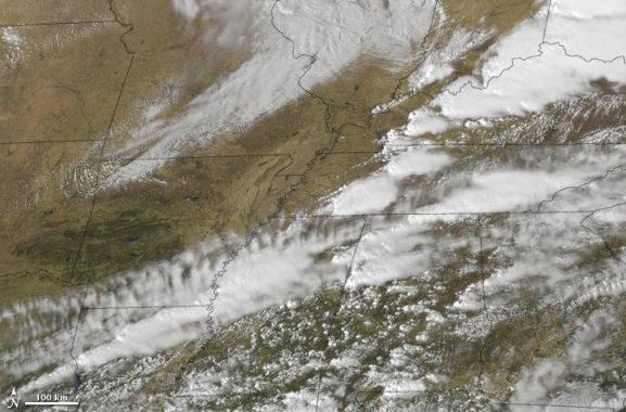
Photo credit above: "
Tornadoes swept the Midwest US on March 2, 2012. In this image, clouds are rendered using thermal infrared (heat) and visible imagery from the Geostationary Operational Environmental Satellite-East (GOES-East). Background land information is from the Moderate Resolution Imaging Spectroradiometer (MODIS).
Image credit: NOAA-NASA GOES Project/NASA Earth Observatory."
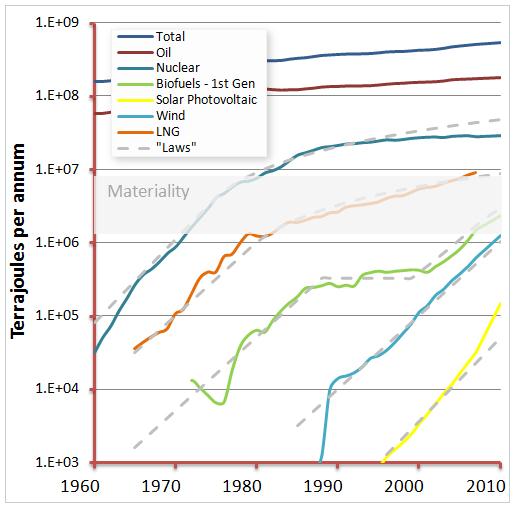
Should We Be Techno-Optimists About Climate Change? Here is a thought-provoking article from
The Energy Collective: "
One of the blogs I read from time to time is that of Paul Gilding, an independent writer on sustainability and former head of Greenpeace International. He spoke at TED last week with a talk called “The Earth is Full”. His blog post this week references the talk and argues why we shouldn’t rely on the “techno-optimist” point of view that all will be okay on the night. "Driven by their optimism bias, people use the clearly huge opportunity of technology to reassure themselves we won’t face a crisis. They believe any serious limits in the system will be avoided because technology will intervene and we’ll adapt." "I discussed this a while back in an earlier post. Two colleagues in the Shell Scenario team published an article in Nature that showed clear historic trends for the deployment of new energy technologies."
Why Climate Change Is A Matter Of National Security. An important story from
Consumer Energy Report; here's an excerpt:: "
I may bring down the wrath of the internet with this essay – I know from experience that talking climate change in a public forum draws out all the trolls. A changing climate, however, is important enough that our national security planners are studying it closely. The Defense Department, the Intelligence Community, and the Department of Homeland Security are closely studying the effects of climate change, particularly how it will impact our security."
A Changing Climate
"First, I will try to pre-empt some criticism from the anti-science crowd by saying that we simply cannot know the future. The climate is notoriously difficult to predict, and models are imperfect. But – climate change is not a matter of ‘belief’ – it is a matter of fact. The fact is that the earth is warming, and has been for at least a century. And, that warming is accelerating: the warmest decade on record was the 2000s, with each of the three decades previous to that warmer than the decade before. Further – it is unequivocal that this warming is being driven by man-made greenhouse gas emissions. I am not a scientist, so I will leave the rest of the explanation to NASA scientist Jim Hansen, who discussed the science of climate change in a recent TED speech."
 Global Warming May Drive You Nuts
. Great. That's not my headline, it comes from the U.K.
Daily Mail: "
The University of Sydney Anxiety Disorders Clinic, Discipline of Behavioral and Social Sciences in Health studied 50 patients and found 14 of them (28%) suffer an obsessive compulsive disorder related to their concerns about global warming. From the study: "Results: The most frequent concerns involved electricity, water and gas wastage. Less frequent concerns included pets dying of thirst and one participant was concerned about house damage due to floors cracking, pipes leaking; roof problems and white ant activity. Compulsions included checking and rechecking pet water bowls, light switches, taps, stoves, skirting boards, pipes, roofs and wooden structures. While these behaviors are not particularly unusual for people with this condition, it was the rationale they provided for carrying them out that was surprising. Instead of checking and rechecking so as to prevent fire or flood, the rituals were specifically performed so as to reduce their global footprint, or respond to climate change-induced negative events."
 Changing The Chemistry Of Earth's Oceans
.
The New York Times has more in this Op-Ed: "
The oceans have always served as a sink for carbon dioxide, but the burning of fossil fuels since the beginning of the industrial revolution, especially over the last 40 years, has given them more than they can safely absorb. The result is acidification — a change in the chemical balance that threatens the oceans’ web of life. In earth’s history, there have been many episodes of acidification, mainly from prolonged volcanic eruptions. According to a new research review by paleoceanographers at Columbia University, published in Science, the oceans may be turning acid far faster than at any time in the past 300 million years."