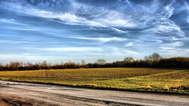
12-14 days above 60? In March? In Minnesota?
Model guidance from the GFS (Global Forecast System) and ECMWF (European) models are suggesting almost 2 straight weeks above 60, maybe 3-5 days above 70, more typical of mid-May than mid-March. We may see a handful of 50-degree days - nothing I would call a "cold front" through the end of March.
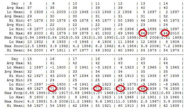
Potential For 6 More Record Highs By Next Tuesday? Here are the records for the Twin Cities over the next 2 weeks. I've circled the records that are in danger of being broken, starting with today's 66-degree record high (2007). We could smash Wednesday's record by 7-8 degrees; after a slight cool-down Thursday (only mid-60s) more records are possible Friday into Tuesday of next week. I am at a rare (and welcome) loss for words. I've never seen anything like this in March.
Climate Calendar above courtesy of the Minnesota Climatology Working Group.
*
Gardeners Beware: although I don't see any sub-freezing temperatures until March 28 (at the earliest) the odds of going through the rest of spring with no more freezing weather is less than 1 in 3. I address this specifically below.
Absolutely Typical - For Mother's Day. Look at these ECMWF (European model) forecast highs - in Celsius of course. Deep breaths. 20 C = 68 F. We stand a very good chance of hitting 70 tomorrow, and low to mid 70s are possible every day from Saturday through Wednesday of next week. That would be 30-35 degrees above average. A couple of days of 60s and 70s are one thing, but the better part of 1-2 (straight) weeks of 60s and 70s? I'm not sure that's ever happened at KMSP, at least not in modern-day records.
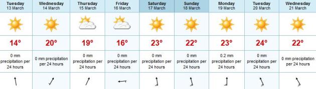
Dig Out The Shorts, Fire Up The Grill. Yeah - having this level of warmth, this early in the season, is a bit unsettling, but there's not much we can do about it - so may as well enjoy it while we can, right? The best chance of topping 70 F. in the metro: Wednesday, Friday, again Monday and Tuesday of next week.
Monday Records:
62 F. record high at Bangor, Maine Monday.
63 F. record at Burlington, Vermont.
65 F. high at Islip, New York.
68 F. high at Syracuse, New York.
69 F. high at Buffalo, New York yesterday, a record.
69 F. record high at Albany, New York.
69 F. high at LaGuardia Airport, in New York City.
71 F. high in Boston Monday, a new all-time record for March 12.
71 F. high in New York City (Central Park), another record.
72 F. high at Providence.
73 F. high at Newark, New Jersey.
74 F. high at Hartford, Connecticut.
"
It was one of those March days when the sun shines hot and the wind blow cold: when it is summer in the light, and winter in the shade." - Charles Dickens.

 March Warmth:
2000
March Warmth:
2000: 5 days in the 60s and 70s during the first half of March in the Twin Cities.
1968: 60+ temperatures for 9 days, from March 21 to March 29.
1872: 9 days of 60+ warmth. Source: Pete Boulay. Minnesota Climatology Working Group.
* there's a good chance we're about to experience the most significant March warmth in 12 years, possibly the warmest March since modern-day records were first kept in 1891.
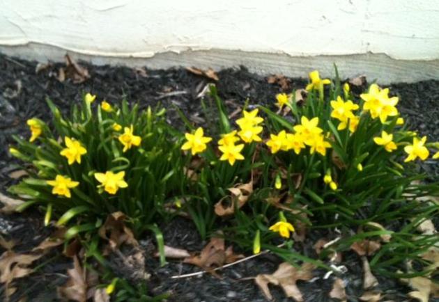
** photos of a bumper crop of crocus and daffodils courtesy of Joan Kruhoeffer, in Lancaster, PA.
Growing Concerns. With no major storms (rain or snow) in sight, temperatures running some 20-40 degrees above average, and the prospect of strong winds and low humidity, I'm growing increasingly concerned about:
1).
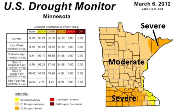
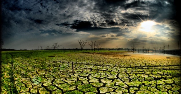
Severe Drought. Nearly a quarter of Minnesota is experiencing severe drought, according to NOAA. The driest counties can be found over southern Minnesota. If we don't see significant rain in the coming weeks moisture will be in very short supply for spring planting. I have a strong hunch that drought will be one of the big weather stories of 2012. I hope I'm wrong.
Click here for more information from the U.S Drought Portal.
2).
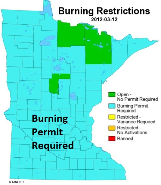
Brushfire Risk. Until we a). see a few big rain storms, and/or b). green up, the threat of brushfires and wildfires will be very significant. Factoring in bright sun, steady winds and low humidity - conditions will be ripe for fires to spread rapidly in the coming 1-2 weeks. According to the
Minnesota DNR burning permits are required across most of the state - conditions will amostly certainly worsen by late March until and unless we see a few 1"+ rain events.
3).
Low Lake Water Levels. I'm hearing some reports of lake water levels as much as 1-3 feet below average, the result of a 7-month drought, very little winter snowfall, and an unusual number of sunny days (which triggered more evaporation before Minnesota lakes iced up in late November). I can see big business ahead for propeller repair shops in the months ahead if the pattern doesn't reverse itself soon. Might be a good summer to use your "beater-boat". The Minnesota DNR has a wealth of information about lake water quality and depth - as soon as the ice comes off the lakes, which may be 2-3 weeks ahead of schedule at the rate we're going. Check out the DNR's
LakeFinder page - you can even download a free app for your smartphone to keep an eye on conditions.
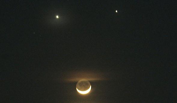
Venus And Jupiter In "Close Encounter". We all get to enjoy a free show (once skies clear); a "planetary conjunction" in the western sky shortly after sunset, the moon, Venus (brighter planet) and Jupiter all clearly visible. The way you can tell they're planets, not stars? Planets don't twinkle. Canada's
CBC has more details: "
Astronomy enthusiasts are gearing up for a dazzling planetary conjunction this week during which Jupiter and Venus will appear to be side by side. In space, of course, Venus and Jupiter are nowhere near each other. But when viewed from Earth, the pair will look as if they are close neighbours. From our perspective on Earth, the two planets will be separated by just three degrees — a couple of finger-widths held at arm's length. "Teamed up with the bright winter stars, the setting should be spectacular," says a posting on the website of the Royal Astronomical Society of Canada."
Photo credit above: "
The planets Venus (top left), Jupiter (top right) and the crescent moon were captured in this photo from Dec. 1, 2008. (Bullit Marquez/Associated Press)."
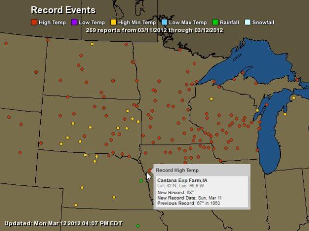
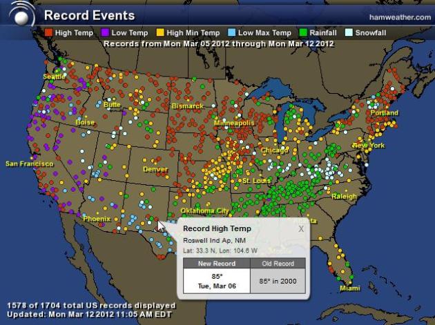
Sunday Records. Click
here to see an interactive map showing the records set on Sunday. I expect hundreds of record highs (and record warm minimum temperatures) this week across the Upper Midwest. Map courtesy of NOAA and Ham Weather.
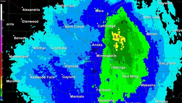
Teased With Rain. NWS Doppler radar estimates show some 1" rainfall amounts east of the St. Croix River Valley. Amounts in the immediate metro area were around 1/3rd of an inch.
15 Cities That Beat The Cold This Winter, From Green Bay To Albany. Information courtesy of
The Daily Beast: "The winter of 2011–12 hasn’t merely been one of unseasonable warmth and little snow—it’s the
fourth-warmest winter ever in the contiguous United States and the warmest in more than a decade. To find the cities that benefited (or suffered, depending on your perspective) most, we weighed three data points. First, the difference between average temperatures and this season’s temperatures in more than 200 U.S. cities during December, January, and February, as recorded by the National Climatic Data Center.
No. 6: Minneapolis
Median average temperature, 2011–12 (departure from normal): 28 (+8)
Snowfall, in inches, 2011–12 (departure from normal): 17 (-11)
Heating degrees below average: -843
* interactive map above shows a week's worth of records, courtesy of NOAA and
Ham Weather.
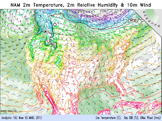 What Just Happened?
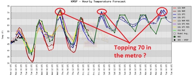
 The core of the jet stream should be howling above Iowa in mid-March. Instead it's about 600-700 miles farther north, flowing above central Manitoba, keeping the coldest cold fronts well north of the U.S. border. A strongly positive AO (Arctic Oscillation) - a signal we've seen most of the winter - will continue to mean unusually strong westerly winds from the Pacific, any bitter air dammed up well to our north. The NAM 84 hour temperature outlook (above) shows unseasonable, May-like warmth building through the end of the week.
 No Real Cold Fronts In Sight.
 Our on-again, off-again storm is on again; the GFS model showing well over 1" rain around March 21-22, as a slow-moving cool front pushes eastward across the state. Ahead of the front:
70s early next week, behind the front we may see a day or two of 50s or low 60s toward the end of next week. My kind of cold front.
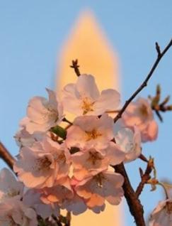
Washington D.C. Cherry Blossoms Destined For Early Bloom, Capital Weather Gang Prediction. The meteorologists at the
Washington Post are predicting an early shower of cherry blossoms in the D.C. area: "The
May-like warmth forecast over the next week promises to give the cherry blossoms a big shot of adrenaline, likely bringing them to peak bloom considerably earlier than normal (which is around April 1). With the big temperature spike ahead, the peak bloom date could come close to the earliest on record (over the last 20 years) of March 17, 2000."
Photo credit above: "
A blossom close-up with the Washington Monument in the background in late March 2009. (Kevin Ambrose)."
MSRPO: Minnesota Seasonal And Recreational Property Owners Coalition. Asian carp were recently found as far north as Winona - a worrying trend. MSRPO is one-stop shopping for lake owners (and renters) to keep up to date on a wide variety of factors. Click
here for more details:
- Take Action at the state and local level to stop zebra mussels, Asian carp and other Aquatic Invasive Species
Read More...
- Other property classes, especially lake homes which have seen dramatic increases of late, are now recognizing the truth that the property tax system is deeply flawed and must be dramatically reformed.
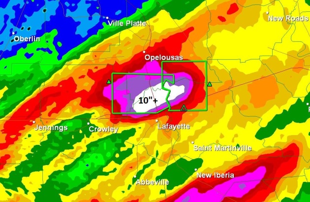
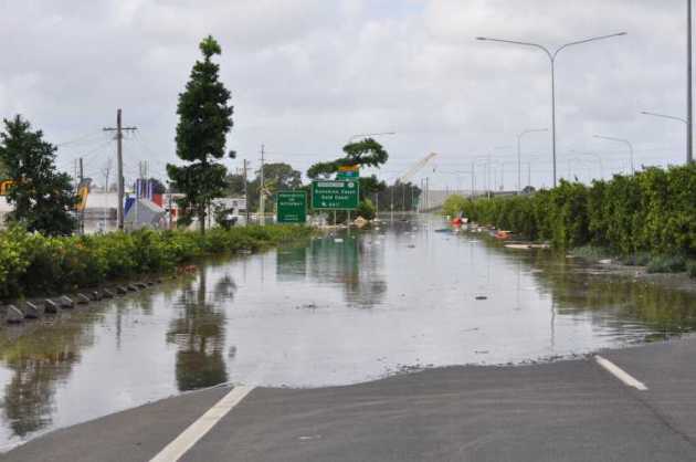
Louisiana Flooding. A complex of thunderstorms has been stalled just north of Lafayette, LA since daybreak (Monday) morning. Extreme rain-fall amounts of over 7 inches in the past 3 hours are causing flash-flooding; Interstate 49 is CLOSED between Opelousas and Lafayette. (NWS Doppler Radar out of Lake Charles, LA at 10:39 Monday morning shows some rainfall estimates in excess of 10" north of Lafayette.
(source:
http://hb.511la.org/main.jsf - - Louisiana Department of Transportation & Development). Thanks to James Aman from WeatherBug for passing this along.
* Lafayette Parish has declared a state of emergency due to flash flooding.
Real-Time Look At Louisiana Flooding. Check out this
WeatherBug (Earth Networks) camera in Scott, Louisiana, showing extensive flash flooding. Some parishes between Lafayette, Lake Charles and Baton Rouge have seen 10-13" rain in the last 24 hours.
Flood Safety Awareness Week. The majority of flood-related deaths occur in vehicles, at night, when it's impossible to estimate water depth. There is a lot of merit to the NWS slogan, "turn around, don't drown." Here are some
additional details from NOAA: "
In 2011 the number of deaths due to flooding was 113 and the damage costs was $8.3 billion. Over the past 30 years floods have killed an average of 92 people per year."
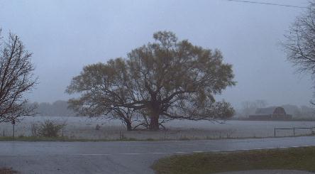
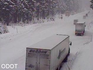
Winter Hanging On. It's not all chirping robins and blooming daffodils. Santiam Junction, Oregon reports 5" new snow, 49" on the ground - tough travel conditions. Webcam photo courtesy of ODOT, the Oregon Dept. of Transportation.
Can You Really Hide From A Tornado? The story from AccuWeather.com and
Live Science: "
In the chilling scenario that a tornado warning is issued for your area, what do the experts feel are the best choices for avoiding serious injury or loss of life? Options range from seeking shelter in basements to interior above-ground rooms to below-ground storm shelters. However, there are pros and cons to all of these options. Many experts agree that your odds for surviving a direct hit with a strong tornado (EF-4 or EF-5) are greatest in a nearby below-ground storm shelter." Photo: National Weather Service.
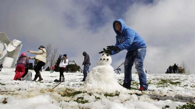
Snow...In Jerusalem? The German web site,
tagesschau.de has the details: "
Ungewöhnliche Freizeitbeschäftigung in Jerusalem. Es hat so viel geschneit, dass man kleine Schneemänner bauen kann. Zum ersten Mal seit vier Jahren konnten sich die Menschen im Norden Israels, aber auch in den Palästinensergebieten über Schnee freuen. (Foto: REUTERS)." I speak sloppy German - almost fluent after a few pints of good, room-temperature German ale, but I have no idea what the caption says. I think it's "unusual amounts of March snow for Jerusalem and the West Bank. Don't quote me on that...
Paul's Links. Here are some of the web sites I use to prepare and update the forecast.
1).
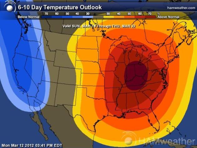
6-10 Day Outlook. This data is created by CPC, and put into map form by the meteorologists and graphic artists at Ham Weather. It's hard to miss the May-like bullseye over the Ohio Valley.
2).
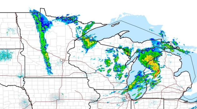
High-Res NOAA Radar Mosaic. NOAA has thousands of useful links for consumer use. This is another bookmark-worthy site, a national (high-res) mosaic that you can pan around and check out the area you're interested in.
3).
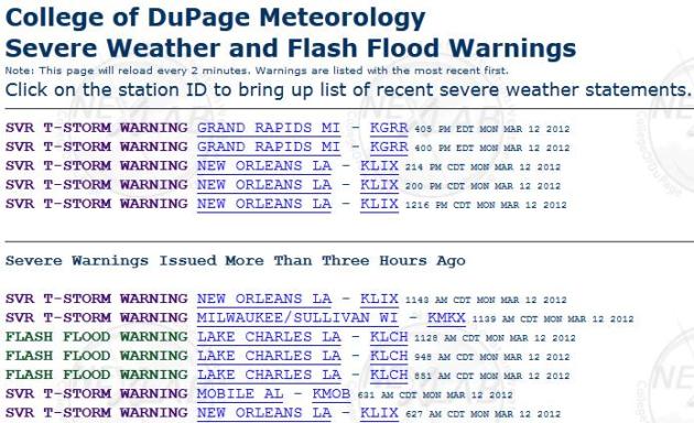
Latest National Watches & Warnings. The
College of DuPage has an amazing web site (and a terrific meteorology program) - one of the products they offer is real-time warnings. At a glance you can see which warnings are still in effect, and which warnings have (just) expired.
"Ask Paul". Weather-related Q&A.
"
I am wondering if this is truly it for winter? I have spring bulbs pushing up, I am eager to uncover the mulch around them and to uncover the perennial beds... is it safe to do so?"
Maggie
Apple Valley
Maggie - although I don't see any sub-freezing temperatures in Apple Valley until the last few days of March, it would be HIGHLY unusual for the metro area to stay above 32 F. through May. That's probably asking too much, in spite of the near-record warmth likely over the next 2 weeks. I suspect it's safe to uncover perennial beds, but I still wouldn't think of planting annuals for another 60 days, just to be safe.
I asked Chanhassen Master Gardener Tricia Frostad, and here was her response:
"
Remove winter mulch in late winte or early spring when you observe new growth under the mulch. If you see mold developing on the plants, it's time to pull back the mulch. Remember that winter mulch protects plants from sudden temperature changes, so it's best to acclimate your plants by pulling the mulch off gradually over a period of days. This allows light and air to reach the new growth slowly, eliminating the chance of shock to your plants. Do keep some of the mulch handy, just in case frost is predicted and you need to protect the tender new growth."
* Tricia adds that she's not removing all the mulch from her garden yet, because "
I don't seriously trust that it's over yet." Neither do I, for the record. I'd be
shocked if we don't see another night or more below freezing for the rest of spring. That would be truly unprecedented.
___________________________________________________________________
For Paul Douglas
"
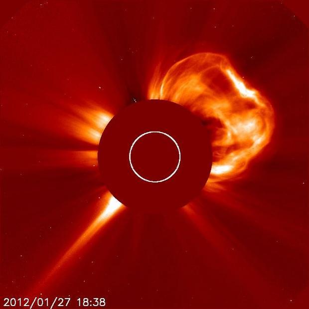
Does your weather/climate change research indicate any possible correlation between our out-of-season warm days and the recent solar flares?"
Rolfe A. Worde
Rolfe- Although I can't see a direct (obvious) link between solar flares and day-to-day weather here on Earth, more research is needed to draw a clear-cut conclusion about these massive solar "CME's" and a possible connection with weather. I checked with Dr. John Abraham, a thermal-fluid specialist in the School of Engineering at the University of St. Thomas in St. Paul. Here was his response:
"
There could be an indirect effect on cloud nucleation. Perhaps these storms (on the surface of the sun) are deflecting cosmic rays, which could, in theory, reduce cloud coverage because cosmic rays nucleate clouds."
___________________________________________________________________
Paul,
"I had the crazy idea that maybe we could start early on a Spring project which is putting on a new deck. To do this we need to dig a couple new holes for supports. Is the ground still frozen? Or could we potentially give this a whirl with the unseasonable temperatures we have been experiencing?
Your input is appreciated."
Thanks,
Molly
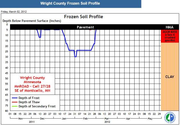
Frost And Thaw Depths. Molly - this may be more than you ever wanted to know about frost depths, but the Minnesota DOT (
Department of Transportation) keeps tabs on frost depth at 12 sites around the state. The closest to the metro is Otsego, in Wright County, which showed a maximum frost depth of 30" the first few days of February. Since then the frost has receded dramatically - with highs in the 60s and nighttime lows (well) above 32 F. I expect most of the frost to be out of the ground by the middle of next week.
P.S. I tried pulling out my stupid driveway stakes Sunday - got about half of them out. I estimate frost depth of roughly 2" or so right now. Give it about a week.
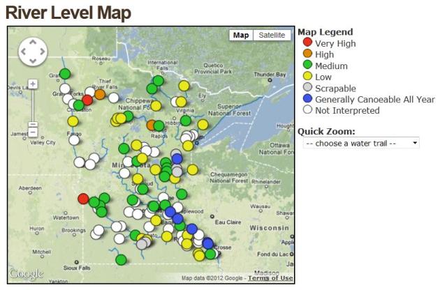
Minnesota River Levels. The Minnesota DNR has a
web site that shows real-time river levels across the state. All those yellow dots above show low river levels, and I have a hunch they're going to continue to drop for at least the next week or two.
_________________________________________________________________________
Hi Paul
"Saw something very interesting the evening of Mar 10. We were at our cabin in Burnett County WI and around 10 or 11 pm I was outside on the deck enjoying a vibrant view of the night sky, looking to the south / east I clearly saw what looked like a beam of light starting at the horizon and moving skyward, like the remains of a jet trail but with sharp lines of a search light. Going back out to look again about a half hour later it was still there and also noticed a moon rise thru the tree tops. An hour later the beam of light was gone and the moon showing all it's colors had moved slightly across the sky.
Can you explain what I had witnessed? Oh, I made my wife come out to verify it wasn't to many "Lienies" and she confirmed the sighting and called it my birthday present."
Dan Elm
Plymouth MN
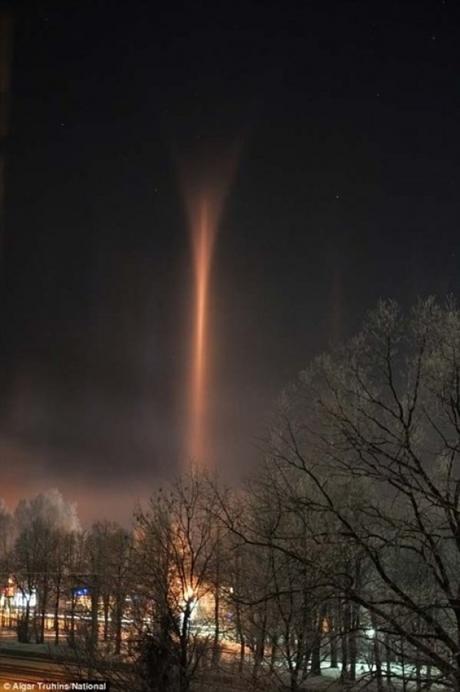
Dan- without a photo it's a little tough to diagnose exactly what you saw. Two thoughts come to mind. Had it been closer to sunset it could have been a case of "crepuscular rays", or twilight rays (upper left), caused by scattering of sunlight. But you said it was 10pm, so that's out. You've heard of sun pillars, shafts of light above the setting or rising sun? You may have seen a (very rare)
"
moon pillar", triggered by light refracting from streetlights or other bright light sources. This is most likely when it's very cold - and ice crystals form spontaneously overhead, which can focus streetlights into narrow shafts of vertical light. The crepuscular ray photo is courtesy of
dipity.com. The (remarkable)
moon pillar in the upper right is from a story about "photometeors: from
zmescience.com.
The iPad Event Was Only Half The Story. More Apple news from
seekingalpha.com: "
Because of the way Apple (AAPL) structures its major announcements — iPad in the first quarter, WWDC and iPhone in the summer though perhaps with the iPhone, now it’s fall — the iPad event is a little weird, because it’s really only half an event. The first half is what happened Wednesday — the unveiling of the new iPad. And the new stuff is mostly about hardware features. The Retina Display. The A5X. The new iSight. LTE. The Retina Display makes it purchase worthy alone, but the other specs Apple bragged about? Just specs. Moore’s Law at play. Talking about them always seems somewhat embarrassing for Apple, a holdover from the days when they used to talk about megahertz and were trying to convince consumers that Pentium chips sucked."
Why Daylight Saving Time Is Pointless.
Gizmodo.com has the reason: "
Ugh. You're up an hour early, your body hates you for it, and even a gallon of coffee can't get your day on track. Daylight savings sucks. But you know the worst part? It doesn't have to be like this. Daylight savings isn't as old as you think it is. First suggested by Benjamin Franklin, in 1784, it was at the time shot down by many very sensible people as being pointless. Then, in the First World War, it was introduced—first by the Germans—to save coal during war time. Somehow in that age of austerity, the concept soon caught on and everyone started doing it. Sadly, nobody's really thought to change back. Except Arizona, and it hasn't fallen off the face of the planet as a result."
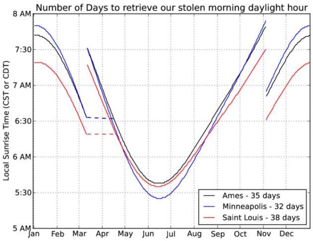 Morning Injustice
. I'm not too indignant about Daylight Saving Time - I
kind of like having it brighter, longer into the evening hours. But I keep bumping into people who are TICKED
OFF
about DST! Here's a post from the
Iowa Environmental Mesonet: "
Today begins the scam that is daylight saving time with an hour of morning sunlight stolen until this fall. The IEM has previously exposed the time change as a means for business to save money. Today's feature shows the local sunrise time along with the number of days it takes until the sun rises at the same time again later in April. It is just over a month with the process going faster the further north you go. If you look at this plot closely, you may notice the sun rising earlier at Saint Louis than Ames in mid June even though Ames is much further north. The reason for this is simple, but do you know why?"
"
When I stand before God at the end of my life, I would hope that I would not have a single bit of talent left, and could say, "I used everything you gave me." - Erma Bombeck
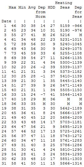
Memories Of March, 2000. 12 years ago MSP experienced 8 days above 60, 2 days in the 70s. I have a (very strong) hunch that we'll see at least 10-12 days above 60 this month, based on a lack of snow cover, prevailing winds aloft, and what the models are hinting at. Place your bets - but I suspect a record-setting (warm) March for much of Minnesota. March, 2000 data above courtesy of the
Minnesota Climatology Working Group.
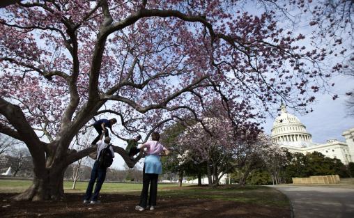
A (Very) Early Spring This Year. Photo credit: "The Stidman family, Fil, front left, and Anna, right and their daughters Laura, back left, and Sarah, of Raleigh, N.C. enjoy the warm Washington weather underneath a blooming magnolia tree on the Capitol grounds, Monday, March 12, 2012. (AP Photo/Manuel Balce Ceneta)."
"March Heatwave"
"By March standards this is a heat wave," said meteorologist Todd Nelson, staring at the maps yesterday. He's right. A streak of 60s so early in the season is unusual, but hardly unprecedented.
Pete Boulay, over at the Minnesota Climatology Working Group, told me that this may turn into the warmest stretch of March temperatures since 2000, when we saw 5 days in the 60s and 70s. The mercury went above 60 for 7 days in March, 1968; 9 days of 60+ readings in 1872.
Now that we've melted most of our snow the sun's energy can go into heating the air instead of melting snow. And considering the sun is as high in the sky as it was on September 29, it is theoretically possible to get a mid-March sunburn.
My semi-educated hunch: this will be the warmest March in Minnesota history. Both the GFS and ECMWF models show (amazingly persistent) 60s and 70s for the next 2 weeks. We may cool off a little by the end of the month, but expect more record warmth - 70 by Wednesday, low to mid 70s early next week? Welcome to May.
Over the weekend smoke from a Le Sueur brushfire showed up on NWS Doppler. I suspect we'll see more fires - and very low lake water levels. We really need more rain.
"
We abuse land because we regard it as a commodity belong to us. When we see land as a community to which we belong, we may begin to use it with love and respect." - Aldo Leopolid, "A Sand County Almanac". Source:
quotegarden.com.
Climate Stories...
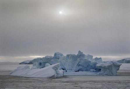
Greenland Ice Melt Seen At Lower Temperatures: Study. The story from
Reuters: "
The complete melt of the Greenland ice sheet could occur at lower global temperatures than previously thought, a study in the journal Nature Climate Change showed on Sunday, increasing the threat and severity of a rise in sea level. Substantial melting of land ice could contribute to long-term sea level rise of several meters, potentially threatening the lives of millions of people. "Our study shows that a temperature threshold for melting the (ice sheet) exists and that this threshold has been overestimated until now," said scientists at the Potsdam Institute for Climate Impact Research and the Universidad Complutense de Madrid, who used computer simulations of the ice sheet's evolution to predict its future behavior."
World Water Supply: Climate Change And Food Pressures Adding Challenges, UN Study. The story from Reuters and
The Huffington Post:
* Rethink vital to meet cross-sector, cross-border claims
* Tripling of groundwater use raises reserve fears
* 6th World Water Forum starts in Marseille on Monday
PARIS, March 12 (Reuters) - The world's water supply is being strained by climate change and the growing food, energy and sanitary needs of a fast-growing population, according to a United Nations study that calls for a radical rethink of policies to manage competing claims. "Freshwater is not being used sustainably," UNESCO Director-General Irina Bokova said in a statement. "Accurate information remains disparate, and management is fragmented ... the future is increasingly uncertain and risks are set to deepen."
Ken Cuccinelli's Climate-Change Witch Hunt. The story from
The Washington Post: "
IF VIRGINIA Attorney General Ken Cuccinelli II (R) needs examples of official waste and abuse as he runs for governor, he could cite the harassment that he conducted against climate scientist Michael E. Mann, a costly episode of government overreach that is finally over. This month, after nearly two years of legal proceedings, the Virginia Supreme Court halted the attorney general’s investigation of Mr. Mann, who used to teach at the University of Virginia. Twisting a law designed to root out embezzlement of state funds and the like, the attorney general had demanded oceans of documents — including Mr. Mann’s e-mail correspondence — from U-Va. But, along with some technical legal problems with his demand, Mr. Cuccinelli didn’t offer any reasonable suspicion that Mr. Mann had committed anything resembling fraud — even as the attorney general proposed violating scientists’ sacrosanct freedom to conduct research without political pressure."
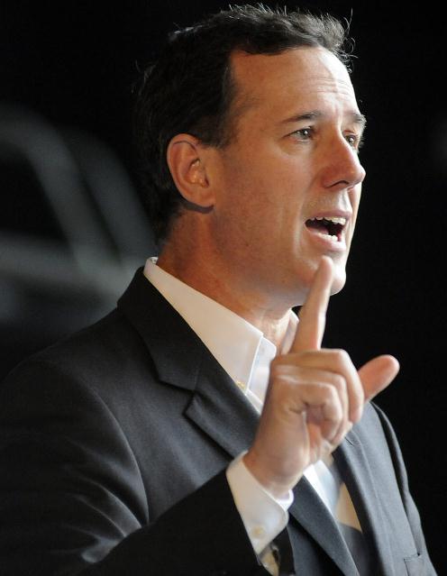 Santorum Bashes "Pseudo-Religion" Of Global Warming Embraced By Rivals.
 The story from
International Business Times: "
Republican presidential candidate Rick Santorum sought to distance himself from his GOP opponents Monday with an op-ed tying Newt Gingrich and Mitt Romney to "radical environmentalists" sounding the alarm on climate change. In a post on the conservative website Red State, Santorum accused Gingrich and Romney of supporting limits on carbon emissions and thereby buying into a doctrine of "trendy liberal elites." Santorum denied any link between human activity and fluctuating temperatures, pointing to an "absence of conclusive, verifiable scientific evidence." "Global warming is the wrong war for America to fight," Santorum wrote. "While millions of Americans are suffering unemployment, their American dream is being blocked by the government rules Romney and Gingrich advocated."
Photo credit above: "
(Photo: REUTERS / Billy Weeks) Republican presidential candidate and former U.S. Senator Rick Santorum speaks during a campaign rally at the U.S. Space and Rocket Center in Huntsville, Alabama, March 8, 2012."