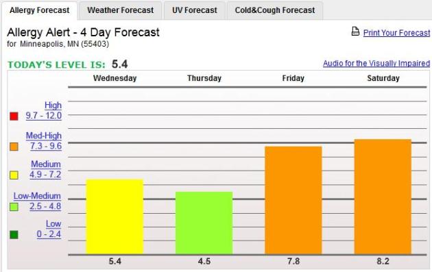
8th least winter snowfall at KMSP since 1884-85. Source: MN Climatology Working Group.

80 F. Wednesday in Miami, Houston and Chicago.
Golf courses opening up in the Twin Cities metro, 4-6 weeks ahead of schedule? The last 10 Novembers have been warm enough for golf in the Twin Cities, but golfing in mid-March? Wow. The unseasonably warm weather is great news for restaurants and cafes, already setting up outdoor seating to attract patrons.

14.2": 1930-31
15.4": 1888-89
17.4": 1986-87
17.5": 1967-68
19.1": 1958-59
20.6": 1920-21
21.1" 1980-81
22.3" 2011-12 (so far)
25.5": 2004-05
45.6": 125 year average (since 1884-85 in downtown St. Paul).
Wednesday Record Highs: some of the scores of records set in the Upper Midwest Wednesday.
68 F. Duluth (35 degrees above average).
57 F. International Falls
Tuesday Records Across The USA:
117 record highs
74 record minimum temperatures (warm nighttime lows)
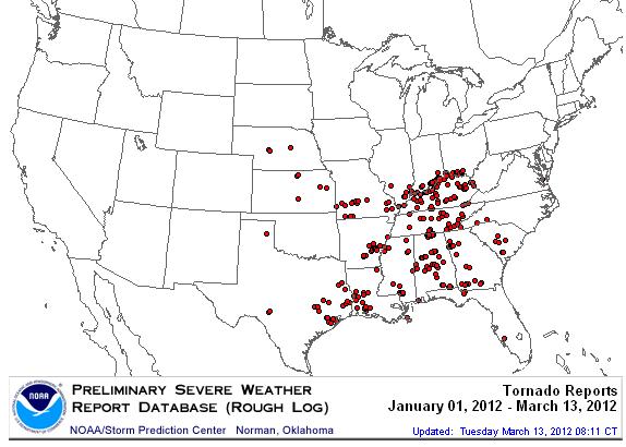
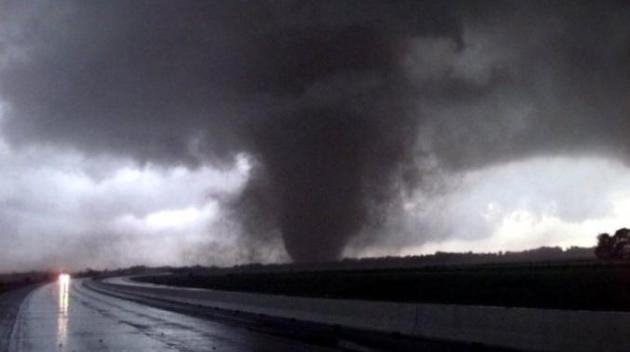
2012 Tornado Touch-Downs. So far 20 states, including Hawaii, have experienced tornadoes so far in 2012. Source: SPC and stormchaser4850.
312 preliminary tornadoes, nationwide, so far in 2012.
55 tornado-related fatalities. Source: SPC.
550 tornado deaths last year, the most since 1917.
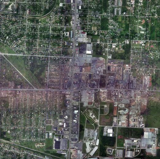
"[People] wanted additional confirmation," Myers says. "They wanted to know they were directly in the path of the storm. If they got it through the television, then they checked their radios. They checked their smartphones. They called people. Many people went outside to see if they could see it coming." - from an NPR article below. Aerial photo taken after the Joplin, Missouri tornado, taken by NOAA.
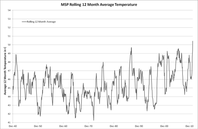
"I was quite surprised when I looked at the rolling 12 month monthly temperature average for MSP. For the first time in MSP history we surpassed 50.0F in October and have been averaging over 53F for the last two months."
Robert A Konetzki PhD
Lead Manufacturing Technologist
General Dynamics Advanced Information Systems

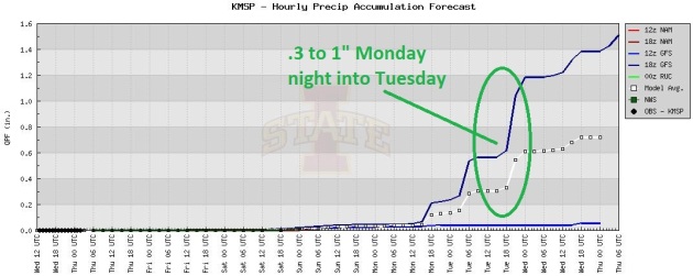
An Opportunity For Rain? A slow-moving eastbound cool front may squeeze out some heavy showers (and T-storms?) anytime from Monday night into Wednesday morning. Right now Tuesday looks like the wettest day. I'll be very surprised if we pick up an inch of rain, at the rate we're going, hoping for at least a quarter or half inch of badly-needed rain.
Isolated Weekend Thunderstorms? A vigorous warm frontal boundary, something you'd expect to see on the weather maps in late May or the first week of June, will approach Minnesota by Saturday - there may be just enough low-level moisture and instability for a few stray T-storms. Now we've skipped mid-May and leap-frogged into early June.
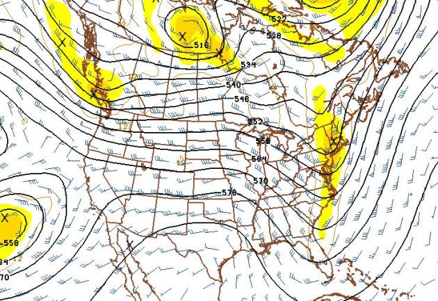
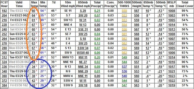
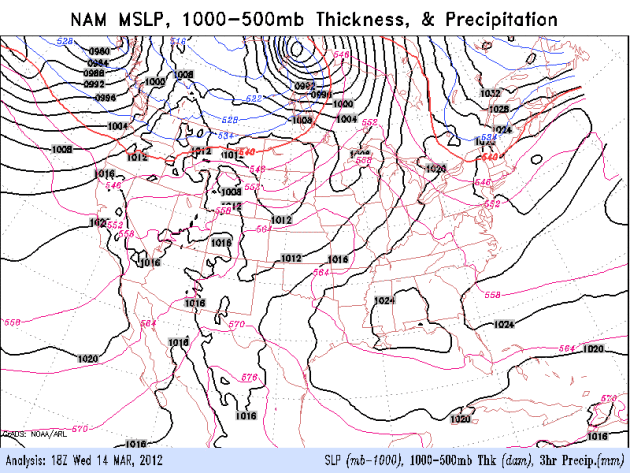
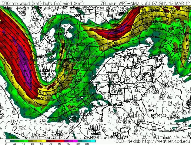
As Far Out As I Dare Look. The 500 mb (18,000 foot) 500mb wind forecast goes out 384 hours. Here is the prediction for March 30, which continues to show a strong zonal, west-to-east flow, hinting at 50s, maybe low 60s from southern Minnesota into Iowa. I think we'll cool down (a bit) in late March, but I still don't see a significant cold front looking out 2 weeks. Nothing "arctic" brewing.
Paul,
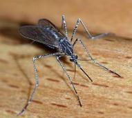
"I decided to enjoy the evening on the deck. I felt something on my arm, looked down and discovered a lethargic mosquito attempting to get a little drink. I humored it for a couple seconds, then sent it to the fishes. I was wondering what is the earliest recorded mosquito sighting in the metro? Someone must keep track of such statistics.
Tom Brown, Brooklyn Park
Oh boy. It's too early for 'skeeters. Thanks for the note, Tom. Off the top of my head I don't have an answer, but I'll check around and see if I can find an answer. Intuitively, this has to be one of the earliest dates, but with ponds and wetlands thawing out rapidly and many already ice-free, I guess I'm not shocked that you had a close encounter yesterday. A six month summer means 6 months of mosquitoes - although if the drought lingers they may not be as bad as previous (wet) years. Stay tuned
5.06" Day Valley, California (Santa Cruz county). 1-4" fell across much of northern California. Details from NOAA.
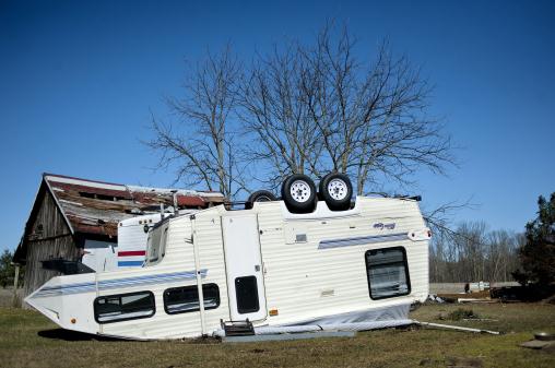
Photo credit above: "A camper sits upside down Tuesday, March 13, 2012, on John and Cindy Mikulin's property, who live off M-18 near the Shaffer Road intersection in Coleman, Mich. Severe thunderstorms that moved across the state Monday night spawned a tornado, with property damage and downed trees reported in the Lower Peninsula. The National Weather Service said Tuesday no injuries were reported following the tornado about 6:45 p.m. (AP Photo/The Midland Daily News, Nick King)."
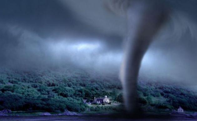
Photo credit above: "Tornado season is underway in the US (Picture: Alamy)."
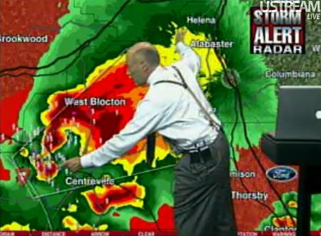
What If Dorothy Had A Smartphone. Here's a fascinating article from NPR: "For many, the only way they learn a tornado is approaching are sirens. In the spring and summer, tornado sirens go off a lot more when twisters roar across Alabama, which has been hit by 900 since 2000, accounting for a quarter of all U.S. tornado deaths. "I am still surprised that so many people rely on just one source of getting warned, and that has to change," said Jim Stefkovich, meteorologist in charge of the Birmingham office of the National Weather Service. James Spann, a longtime television meteorologist at Birmingham's ABC affiliate, says the reliance on sirens has led to dozens of deaths over the years. "In the siren mentality, it's the idea that you're always going to hear a tornado siren before a tornado strikes. And I believe it's a farce."
Photo credit above: "This May 3, 1999, funnel became the F-5 storm that damaged thousands of buildings in central Oklahoma. University of Oklahoma storm chasers and observers are anticipating the annual tornado season as it approaches the central part of the country. Photo: J Pat Carter/AP."
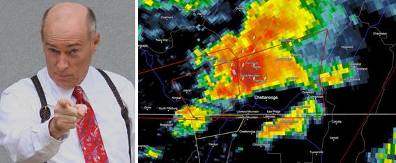
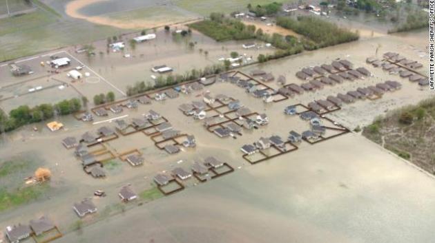
Photo credit above: "CNN and Lafayette Parish Sheriff's Office."
"Nice to return from Florida to Florida, eh?
NWS saying the jet stream is to our north is not sufficient reason for these temps. We are talking 30+ above normal every day for nearly two weeks.
What's the cause? Is the whole continent warm right now?
Also, what's the precedence for a run of 10 days of 30 degree off the averages? When has that happened before?"
Adam Platt, Minneapolis/St. Paul Magazine
Adam - it's a baffling pattern, no question. The AO (Arctic Oscillation) is still trending very positive, meaning overwhelming westerly winds aloft, with bitter air trapped over northern Canada and Alaska, a pattern we witnessed most of the winter. An unusually strong Pacific storm is amplifying a trough of low pressure in the west, which is increasing a south/southwest wind flow aloft east of the Rockies, an unusually strong high pressure bubble over the southeastern USA. Right now near-record warmth is blanketing the eastern 2/3rds of America - highly unusual for mid March. Here are some additional thoughts from Pete Boulay, at the Minnesota Climatology Working Group:
One difficulty in those kind of statistics is that "normal" changes every 10 years so it is hard to compare. Here's a few candidates though...
and this month had 3 (30 averages) above normal.
I'm just talking average temperatures here, not just the maximum temperature.
In order for the next ten days to be 30 plus above normal, the average temperature (including the low) will have to be 62-64 degrees, we will be close to that, but some of the days the average will be in the mid 50's.
If we see more than five 70-degree temperatures, that would be unprecedented in the Twin Cities Climate Record, but it is hard to count our 70s before we have them. :)
Thanks Pete (and Adam).
________________________________________________________________________Dear Paul,
"We keep hearing all the dire effects of Global warming and rising sea levels. Some of these effects should be visible now. Have the oceans increased any measurable amount? Given the best predictions we have now can you give a timeline of each year and expected rise in ocean levels?"
Thank you.
Rod
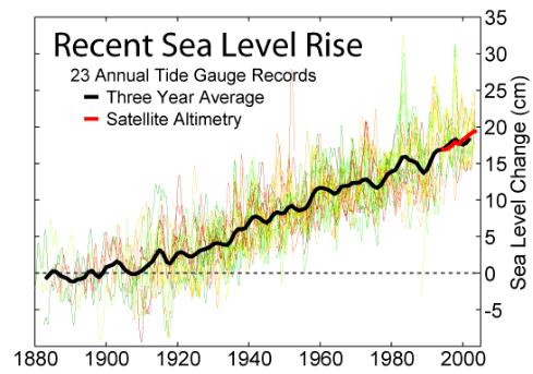
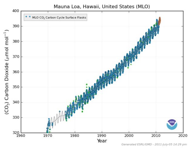
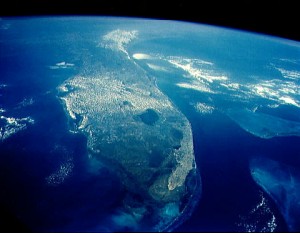
Rod - great question. I tell people who are skeptical by nature that, even if you choose not to believe the thousands of peer-reviewed Phd climate scientists who predicted some of the trends we're seeing show up on the maps today, at least believe your own eyes. A trend toward drought west of the Mississippi River, more frequent weather extremes, more flash flooding, warmer (shorter) winters, all of these things were predicted 25-30 years ago. And it's happening. If you step back, look at the big (global) picture over time, you can't pretend that the patterns aren't changing, at least not with a straight face. For some professional skeptics and deniers there will never be enough "evidence". They will continue to cherry-pick and look for excuses to deny the obvious. I encourage people not to look for evidence of climate change by looking out at their back yard thermometer, but take a good, long look at your yard: new flowers, insects, birds and plants growing (earlier) that weren't there a generation ago. It's a slow-motion transformation, but it's happening. The New York Times just ran an extensive article on the risk of rising sea levels to an estimated 3.7 million Americans. Florida is most at risk. We've already seen sea levels rise 8", and an additional rise of 1-2 feet is possible by the end of this century. The big wild card: Greenland, which appears to be melting much faster than the weather models predicted it would.
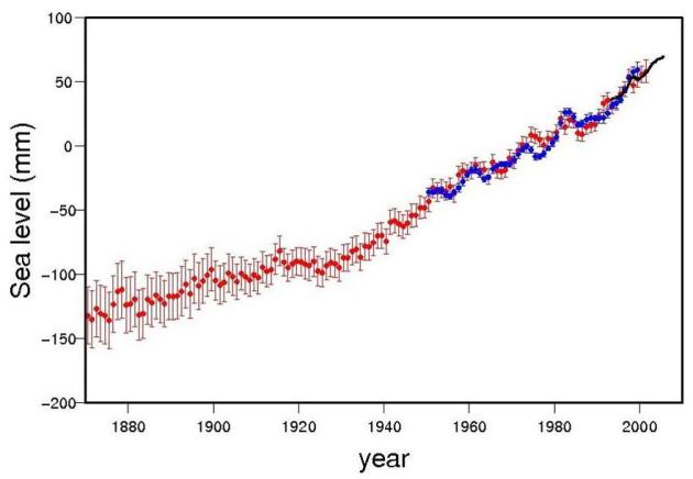
"6 inches is the amount for the 20th century with an error bar, but it is 2.2 inches since 1992 (3.2 mm/yr) since Topex/Poseiden went up), so 8 inches is not bad." - Kevin Trenberth
"Wikipedia graph (below) shows just under 20cm since 1900 (i.e. 7.9 inches). Locally it can be higher (twice this in New Orleans, also in Chesapeake bay), smaller trends in Maine (glacial uplift)." - Gavin Schmidt

Toilet Paper Crisis Averted In New Jersey's Capital City. Oh thank God. The "story" from Yahoo News: "(Reuters) - The great toilet paper crisis in New Jersey's capital city is over. Police, firefighters and other Trenton city workers down to their last sheets as the result of a City Council budget battle were rescued late Tuesday by animal rights advocates who offered six months of free rolls printed with a message about filthy slaughterhouses and the resulting fecal matter found in meat. New rolls of paper were expected to begin arriving in city offices and facilities on Wednesday, thanks to the donation from People for the Ethical Treatment of Animals and an emergency appropriation of $16,000 by the City Council." Photo credit: ava7.com.

Spring Break Optional
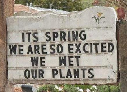
Sign outside a Tucson, Arizona gardening store: "It's spring. We are so excited we wet our plants." Get ready to do a lot of watering in the coming weeks/months. As we slip deeper into drought I have a (strong) hunch we'll be dealing with inadequate soil moisture, low lake water levels, brushfires, even watering restrictions by summer.
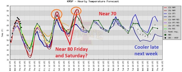
If it's 80 in mid-March, what's it going to be like in July?
One silver lining to our new, warmer Minnesota: no need to flee to Florida for Spring Break. This year Spring Break is coming to us. I see 5 more days above 70 through Tuesday of next week; models hinting at 80 Saturday afternoon. 80! That's the average high for June 19. Remarkable.
The upper atmosphere may be too warm for T-showers through the weekend; the best chance of rain Tuesday. A few long-range models are hinting at cooler weather the latter half of next week (50s). You may even need a light jacket. But for the next 5 days shorts and T-shirts will be perfectly fine.
"Is this warmth evidence of climate change?" The honest answer: we don't know. Even if you choose not to believe thousands of climate scientists, believe your own eyes. Our weather patterns are changing.
* photo credit above here.
Climate Stories...
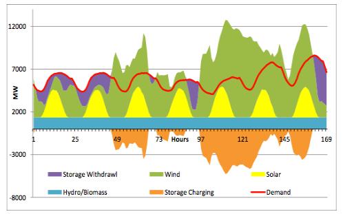
Graph credit above: "The following chart from the report illustrates how wind, solar, other renewables, and storage adjust to meet customer demand during a typical week in July, with both supply and demand being flexible."
Record La Nina Linked To Climate Change. Details From The Australian: "THREE of the nation's leading climate scientists have linked the past two years of record wet weather to climate change in their strongest findings yet on the impact of global warming on the nation's climate. Professors Will Steffen, Matthew England and David Karoly, in a paper to be released today by the Climate Commission, find global warming may have contributed to the strength of the La Nina event and the heavy rainfall and flooding. They also contend that the heavy rains do not contradict the trend towards drier weather for southern and eastern areas of Australia and find that despite two years of above average rains, southeast Australia continues to suffer from a cumulative rainfall deficit." Photo credit: ozcoasts.gov.au.
Baptists And Climate Change. Here's a story from The Yale Forum On Climate Change And The Media: "America’s roughly 52 million Baptists hold a wide range of views on environment, and for many of them, scripture is the key to their attitudes toward climate change. When God created the first man and woman, he blessed them and then, Genesis teaches, delivered instructions that would resonate for millennia: “Fill the Earth and subdue it,” he said. “Rule over the fish in the sea and the birds in the sky and over every living creature that moves on the ground.” In 2007, the Southern Baptist Convention drew on this passage in a resolution on global warming declaring that Christians should exercise dominion over the Earth, and that the U.S. government should reject mandatory cuts in greenhouse gas emissions."
Carbon Emissions Hit New Record. An update from The Sydney Morning Herald: "GREENHOUSE gases have risen to their highest level since modern humans evolved, and Australian temperatures are now about a degree warmer than they were a century ago, a major review by the CSIRO and the Bureau of Meteorology has found. The national climate report, to be released today, said Australia's current climate ''cannot be explained by natural variability alone'' and that emissions resulting from human activity were playing an increasingly direct role in shaping temperatures." Graphic credit above: NOAA.
A new report released yesterday by the Institute for Energy and Environmental Research shows that Minnesota can meet 100% of its electricity needs with in-state wind and solar power, and (with ample energy efficiency investments) at a comparable cost to its existing electricity supply.
Florida At Highest Risk For Flooding From Sea Level Rise, Report Finds. A few details from the Miami Herald: "The analysis was based on a projected potential rise of four feet, with increased damage from hurricane storm surge and flooding from seasonal high tides compounding the threats. Overall, Florida also ranks as the most vulnerable to sea level rise, with some 2.4 million people, 1.3 million homes and 107 cities at risk from a four foot rise, according to the report. Louisiana, by comparison, has 65 cities below the four-foot mark. New Jersey and North Carolina have 22 each, Maryland 14 and New York 13." Photo credit above: NASA.
Source: Clean Technica (http://s.tt/17kjx)