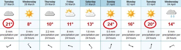
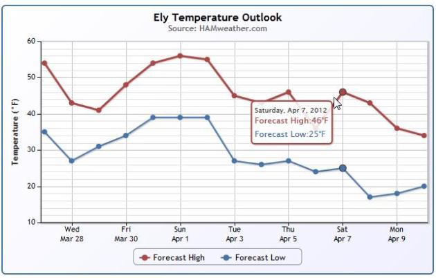
April 3-5: potential for a major storm, mostly rain - with potentially high winds for the Upper Midwest. Details below.
48.3 F. average temperature for March at MSP (averaging highs and lows for the first 25 days). This is 3.6 F. warmer than the previous record for warmest March, 1910.
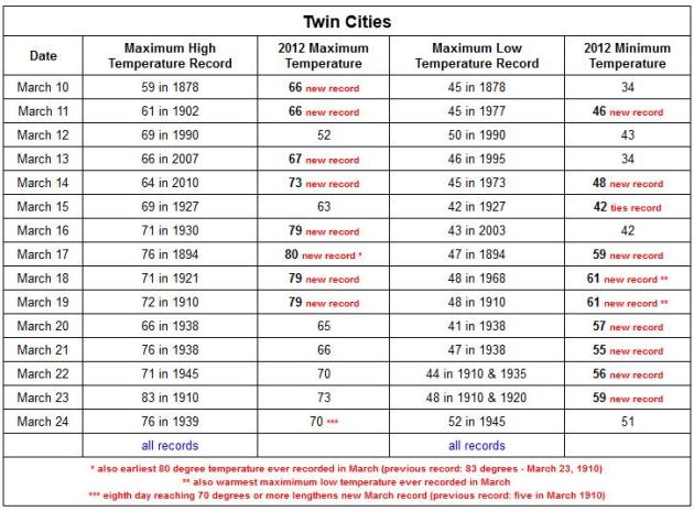
18 warm weather records so far in March at KMSP.
61 F. warmest nighttime low ever observed in March, recorded on March 19 and 19.
80 F. on March 17; earliest 80-degree reading ever recorded in the Twin Cities. Previous record was 83 on March 23, 1910.
8 days above 70 in the Twin Cities so far this month, breaking the old record of 5 days in 1910. Source:
Minnesota Climatology Working Group.
10,000+ daily weather records across the USA since March 1. Source: NOAA.
ECMWF Model: 3 More 70-Degree Days Over The Next Week? The (often more reliable) European model hints at low 70s today...nice, if you don't mind 40 mph. gusts and grit in your eyes. Sunday's highs may reach the mid 70s to near 80, another shot at 70 on Tuesday.
Jackets And Shorts. It's a confused weather pattern. Understatement of the month. HIghs top 70 today, we cool down into the 30s by Thursday morning (but I think we'll miss a frost, at least in the MSP metro area), before warming up to near 70 Saturday, possibly 75-80 on Sunday.
4X: computer models estimate the odds of a heat wave, similar to the extreme scorcher that left tens of thousands of Europeans dead in an historic 2003 heat wave, has likely quadrupled as a result of humanity's effects on climate. Details below from Live Science. Image above courtesy of
Blue Marble Research and NASA's MODIS Program.
"
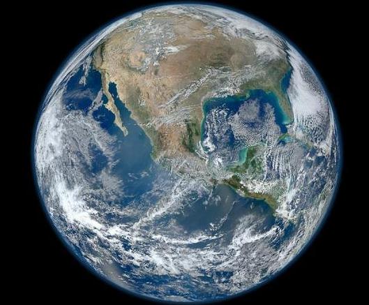
One of the most worrying and unknown thresholds is the Siberian permafrost, which stores frozen carbon in the soil away from the atmosphere. "There is about 1,600 billion tonnes of carbon there - about twice the amount in the atmosphere today - and the northern high latitudes are experiencing the most severe temperature change of any part of the planet." - from a
Reuters article on a possible climate tipping point. Image: NASA's Blue Marble.
19 tropical storms in 2011, tied for the 3rd busiest season on record. Image courtesy of
NASA.
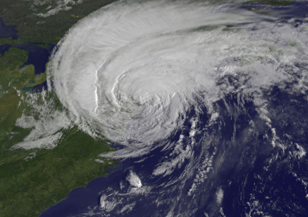
3 tropical cyclone landfalls in the U.S. in 2011 (average). Strongest was Hurricane Irene, the first hurricane to make landfall on the U.S. mainland since "Ike" in 2008. Details below.
"
A warming tropical Pacific and a cooling tropical Atlantic are leading us to think that the 2012 Atlantic hurricane season will have less activity" than average, meteorologists Philip Klotzbach and William Gray wrote in an online report." - from a KETK-TV story below.
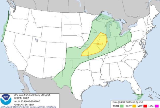
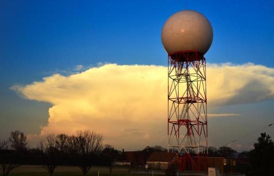
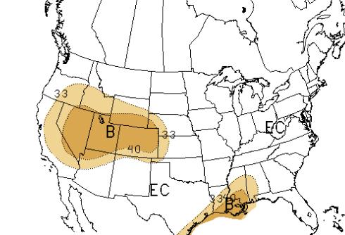
Tuesday Severe Risk. An advancing cool front may spark a few strong/severe T-storms from Madison and Peoria to the Quad Cities, St. Louis and Kansas City later today, according to
SPC.
Remarkable March Statistics For The Twin Cities and St. Cloud. Data courtesy of NOAA.
MSP Airport: Avg Temp: 48.6° (+17.2° Above Avg.) (+3.6° Above Warmest March on Record)
Warmest March on Record 45.0° in 1910
STC Airport: Avg Temp: 43.3° (+15.2° Above Avg.) (+0.3° Above Warmest March on Record)
Warmest March on Record 43.0° in 1910
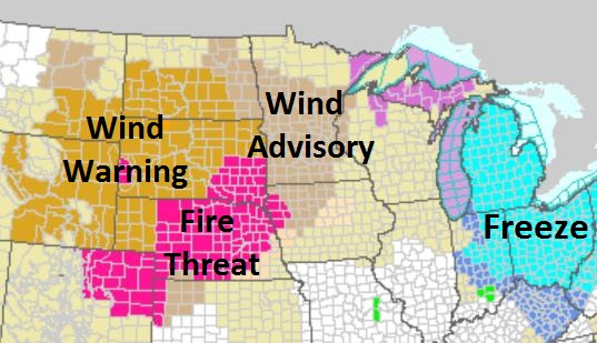
A Very Bad Hair Day. An intensifying storm tracking into northern Minnesota will create a strong pressure gradient today, southwest winds gusting to 45 mph in the metro, as high as 60 mph across the Dakotas. A Red Flag Warning is posted from eastern South Dakota to Denver for a very high fire risk. More from NOAA
here.
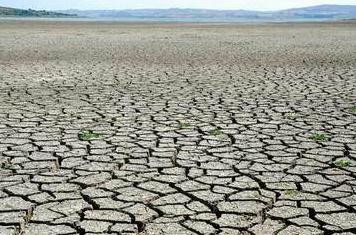
Low Lake Water Levels. Expect to pay more for a few extra sections of dock this summer, no matter what lake you're on. I still don't see any dramatic changes in the pattern that would bring (significant) rain into Minnesota. My head hopes for a wet spring/summer, but my gut is still going with drought. Details below.
"
If at first, the idea is not absurd, then there is no hope for it." - Albert Einstein. Photo: City of Palm Desert.
"Chicago’s average temperature for the first 21 days of March would tie for the seventh-warmest April on record there, the National Weather Service reported." - from an article at Climate Central, below.
March Heat Wave: "
Kevin Trenberth, a climate scientist at the National Center for Atmospheric Research, said he views the situation somewhat differently. “Indeed [greenhouse gas-driven] warming is not dominant, but I suspect when all the evidence is in we will find that the event likely would not have occurred without global warming, the odds will be so low,” he said." - from an article by meteorologist Andrew Freedman, below the 7-Day.
"
It´s like a game with loaded dice," says Coumou. "A six can appear every now and then, and you never know when it happens. But now it appears much more often, because we have changed the dice." The past week illustrates this: between March 13th and 19th alone, historical heat records were exceeded in more than a thousand places in North America." - from a story at EurekaAlert.com, details below.
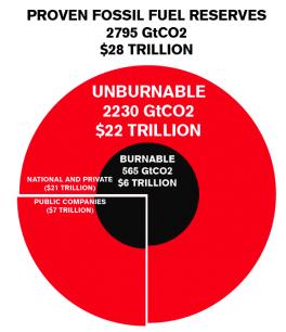
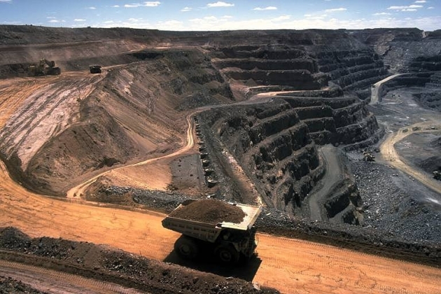
$20 trillion. A rough estimate of the value of carbon resources (coal, gas and oil) still in the ground in the USA. Experts estimated 80% of this carbon will need to be "stranded" (not mined, drilled or ultimately burned) to prevent a worst-case climate scenario. Details from Think Progress below. Photo: EPA.
What Do Warm Marches Tell Us About The Date Of The Final Spring Frost? Here's an excerpt of an informative post from Greg Spoden, the Minnesota DNR Climatologist: "
The abnormally warm March temperatures have rapidly advanced spring phenology and hastened early-spring agricultural work at a pace seldom seen at this time of year. Two questions arise: 1). What will be the impact of spring frosts when they inevitably occur? and 2). Do exceptionally warm Marches foreshado earlier-than-average last spring frost dates? The answer to question #1 is of course highly dependent on the nature of the impacted landscape. However, the answer to question #2 can be addressed using historic data:"
Rank Year Final Spring Frost Date
1 1910 April 25
2 1878 April 6
3 1946 May 12
4 2000 April 21
5 2010 May 9
6 1973 May 17
7 1945 May 10
8 1918 April 30
9 1968 May 5
10 1987 April 23
"
Using the past as our window to the future, it is apparent that a warm March offers us no obvious indication about when the final spring frost will occur. 139 years of Twin Cities temperature data were reviewed." - Greg Spoden
March Records Since March 10. 18 and counting, although I suspect we may set a few more records (for warm nighttime lows) by Saturday, March 31. Chart above courtesy of the
Twin Cities office of the National Weather Service.
"Working The Ground". Here's a
YouTube clip from Noble, Illinois, showing farmers out in their fields on March 23. That's at least a month to 5 weeks ahead of schedule. "
Early spring, beautiful day, John Deere 8630, Willrich field one pass finishing tool with remlinger double rolling harrow."
Lake Minnetonka Conservation District Monitors Lake Levels On Lake Minnetonka. Lake water levels continue to drop on area lakes - officials are monitoring the situation (and the forecast for April, which shows no significant moisture through roughly the first half of the month). Here is an excerpt of a press release that went out from LMCD on March 8: "
Below normal precipitation since last fall has been on the forefront of discussion for many Lake Minnetonka residents. While the water may seem low now, historical Lake levels were similar in 2000 and 2009. Additionally, levels were dramatically lower in the late 1980’s and early 1990’s. On February 7th, the Minnehaha Creek Watershed District (MCWD) reported the water level reading on Lake Minnetonka to be 927.93 feet. When Lake levels fall below 928.0 feet, the Lake Minnetonka Conservation District (LMCD) Code states that the Board of Directors may approve a resolution that allows for temporary dock length extensions for licensed (multiple dock facilities) and unlicensed (primarily residential) sites on Lake Minnetonka."
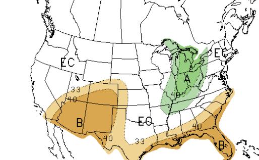
April Outlook. NOAA's CPC (
Climate Prediction Center) is predicting warmer than average temperatures for much of America next month, with the exception of a cool bias for the Pacific Northwest. The precipitation outlook (upper left) shows a higher chance of wetter-than-normal weather for the Great Lakes and Ohio Valley; rainfall across Minnesota could go either way, but if I had to bet, I would gamble on a continuation of a drier pattern. "When in a drought, don't predict rain" right? Map legend: green: above average, brown, dark brown: warmer than average.
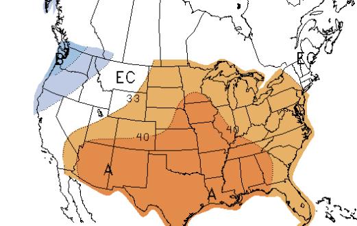
3 Month Outlook. The
CPC precipitation outlook into June shows a continued dry bias across much of the USA. It's unusual not to see any above-average precipitation predicted anywhere in the Lower 48 States. We're going from a moderate La Nina cooling phase to a possible El Nino warming of the Pacific. With any luck that will mean a return to normal or above-normal rainfall by summer, but short-term, I suspect the drought may get worse before it gets better.
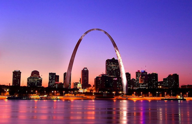
Warmest St. Louis On Record? Here are some numbers from the
St. Louis National Weather Service:
ST. LOUIS
PERIOD OF RECORD: 1874 - PRESENT
1) 59.8 2012 THROUGH 3/25 (60.7)
2) 57.5 1910
3) 56.3 1946
4) 54.3 1878
5) 54.0 1938/1921
7) 53.6 2007
8) 53.4 1945
9) 52.9 1907
10) 52.6 1918
* photo above:
flickr.
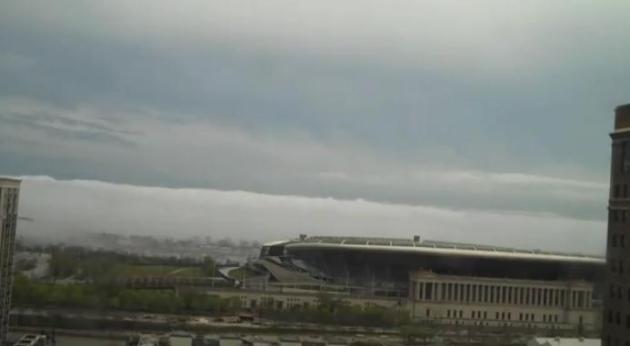
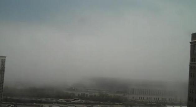
Timelapse Of Fog Rolling Off Lake Michigan Into Soldier Field. Thanks to
bradmurmz and YouTube for sharing this remarkable clip: "
Timelapse of fog rolling in off the lake and over Soldier Field in Chicago on March 23rd."
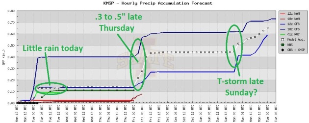
Best Chance Of Rain: Thursday Night. The models print out a little rain today, but I suspect most of the showers will detour well north over northern Minnesota, a few strong/severe storm possible over southern Wisconsin. The next chance of real puddles: Thursday night.
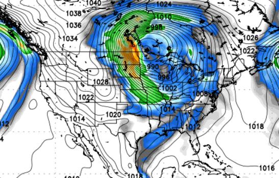
Major Early-April Storm? Here is the April 3 GFS outlook for 12z April 3, showing a very powerful cyclone spinning up over the Upper Midwest, with a potential for heavy rain (ending as wet snow?) and winds topping 50 mph. Image courtesy of NOAA and
policlimate.com. I don't believe it, at least not yet. The GFS has been very unreliable lately, latest runs kill the early April storm.
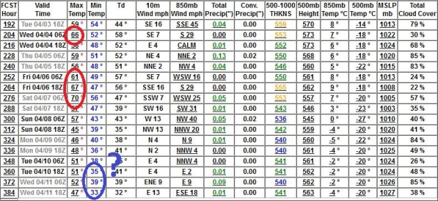
Our Fleeting Frost Prospects. Our (historic) warm bias lingers into the first week of April, a cooling trend predicted by the GFS for the second week of April. The models keep pushing back any risk of frost; the latest run hinting at lows near 32 F. by April 10-11, but my confidence level is about as low as it gets. That said, hold off on the annuals another month (at least), just to be safe.
National Hurricane Conference Begins This Week In Orlando. The story from
abcactionnews.com: "
ORLANDO - Despite an unprecedented early spring heat wave that helped break records across the country last week, it's the warming waters halfway across the world that have the attention of scientists and storm chasers as they begin the annual National Hurricane Convention this week in Orlando. That warmth in the waters of the Equatorial eastern Pacific may signal the anticipated end of the current La Nina event, which has helped trigger higher-than-normal storms traffic across the tropics during the past few Hurricane Seasons. Last year, a total of 19 tropical storms were tracked during the June 1-November 30 period." Image above courtesy of NASA.
Upcoming Hurricane Season Could Be Quieter Than Normal. Some good information in this post from
KETK-TV: "
With just over two months to go before the 2012 hurricane season begins, the first preaseason predictions have been released. The six month season that begins on June 1st should be quieter than normal, according to Colorado State University meteorologists Philip Klotzbach and William Gray. "A warming tropical Pacific and a cooling tropical Atlantic are leading us to think that the 2012 Atlantic hurricane season will have less activity" than average, meteorologists Philip Klotzbach and William Gray wrote in an online report."
Early Storms Fuel Awareness As Spring Begins. A story about the importance (and sudden popularity) of NOAA Weather Radio in this post from
Claims Journal: "....
He said when bad weather strikes, people should “use common sense. If there is a possibility of a bad storm, pay attention to all media and rely on warnings.” Wielgos recommended that residents get weather radios and that will give them warnings for counties to the west. Storms most often move from west to east in the area, she said. Brad Jackson, a Radio Shack manager at Kentucky Oaks Mall, says weather radios are selling better this year than they before spring last year."
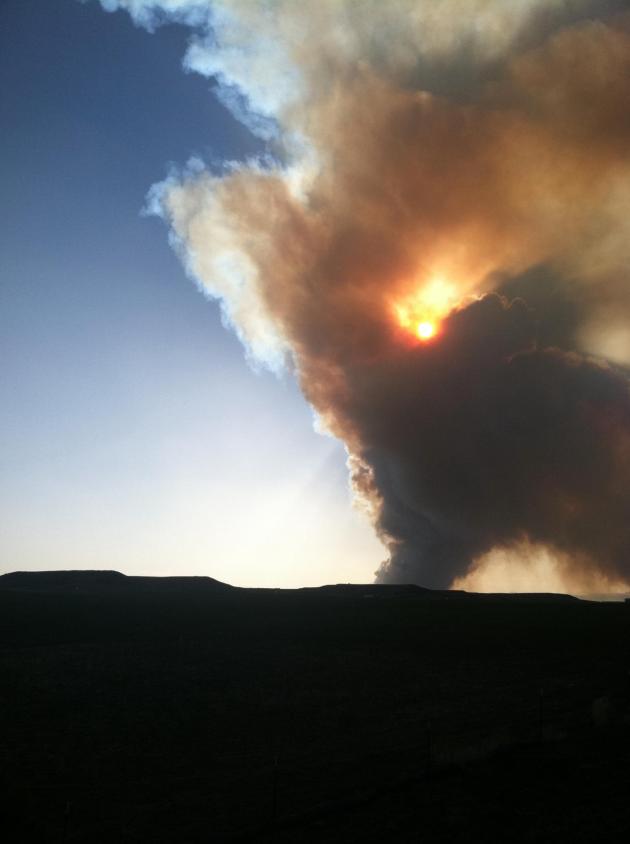
Photo Of The Day. Thanks to Anikah Norton, from the Denver area, for sending in a spectacular photo of the Jefferson County, Colorado wildfire.
Hundreds Forced To Evacuate Because Of Jefferson County (Colorado) Wildfire. Fire season is coming early this year, because of a lack of significant snow, bright sun and gusty winds.
9news.com has more details: "
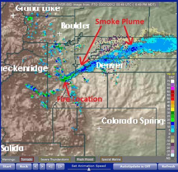
JEFFERSON COUNTY - Residents are being evacuated to Conifer High School in Jefferson County because of a fire moving north toward Pleasant Park. The fire is burning out of control southeast of Aspen Park and is one of several that broke out on Monday afternoon as high wind gusts swept over the Front Range. Jefferson County Sheriff's Office spokesperson Jacki Kelley says the Lower North Fork Fire is now more than 200 acres and is burning in an area near Conifer on Buffalo Creek Road near Foxton and River roads." Smoke plume on Doppler radar courtesy of NOAA.
"Ask Paul". Weather-related Q&A, comments, rants...and threats.
"
Took a run over the ridge to check out the ice on Burntside Lake. It's very, very rotten on the west end and will probably go out tomorrow with some more wind. The cold is inconsequential. The ice is going out!. I'm planning a canoe trip to Quetico park via the BWCA and Stuart River on Thursday or Friday. Any idea how cold and how much wind to expect up here on the border from Thursday to Monday? I see the Cites gets warm on the weekend but what about us?"
Thanks,
Steve
Hi Steve - love your question, and the fact that you're considering canoing in the BWCA in late March. Where are we living again? This can't possibly be the same Minnesota we grew up in. You're in luck: no chin-deep snow drifts. Looks like highs near 60 (!) on Saturday, then cooling into the 50s Sunday, possible 40s for highs by Monday. Pack warm, nights will still dip into the 30s - but these readings are a good 20 degrees above average. There's a slight chance of thunder late Sunday, a few rain showers on Monday - but no major storms brewing. Have fun up there?
* to get the latest trend for your hometown click your zip code into
this URL, courtesy of Ham Weather.
______________________________________________________________________
Paul,
Question 1
Driving around this past weekend we noticed a number of flowering crab apple trees in full bloom. Will these trees have fruit if there are no insects like bees out yet to pollinate the flowers?
Question 2
Last summer we observed an unusually large population growth of earwigs. I know that from my college entomology collection that earwigs are common in Minnesota, but not in the numbers we saw last year. With the mild but dry winter it would be interesting to document what insect pests will emerge in unusually large number this summer.
Thanks,
Allen Frechette
Environmental Health Manager
Scott County
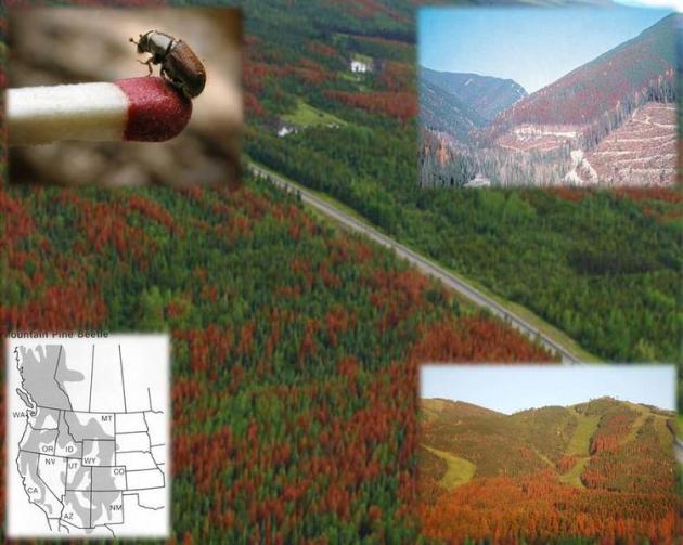
Scott - thanks for a couple of good questions (that are, truthfully, above my paygrade). It's early for everything to be in bloom, so the bees apparently haven't gotten the memo about our premature spring. If we still don't see bees a month from now, in late April, that's when I start to worry. For now I suspect pollination will take place late, but it will happen. You can't stop those spring hormones. My knowledge of earwigs is limited, but your observations are in line with what we're seeing with a recent trend toward milder winters. Many pests are killed off when temperatures don't reach -30 to -40 during the winter. We just haven't seen the volume of arctic air recently that we did in the 60s, 70s and early 80s. That means many pests can live yearround, and proliferate, with potentially dire consequences. There's a lot of concern about pine beetles, which have destroyed millions of acres of forestland from the Rockies into western Canada. With a lack of bitter air they can live, multiply, and chomp their way to vast amounts of wood, yearround. God help us if the pinebark beetles reach the BWCA. Image above courtesy of the
Bark Beetle Epidemic Wiki.
Sports Broadcasting "More Stable" Than TV News? We'll miss you Mike - good luck out in San Diego (best climate of any large city in the USA - but you probably knew that already). You're going to miss our winters - just wait. TVSpy.com has the story: "
Leaving his main anchor post at KARE for a job with the San Diego Padres, Mike Pomeranz says he has a hunch that sports broadcasting is more stable than TV news. “I like the fact that Dick Enberg is doing it at 77 years old,” Pomeranz told the Star Tribune recently, referring to the legendary sportscaster who currently does play-by-play for the Padres. “You can’t watch sports on a larger screen [than the ballpark],” he added. “Everybody wants to see it on an 80-inch screen. News you can get on your phone, and it’s trending in different directions.”
The iPhone 5 Will Be Much Larger Than The iPhone 4S. Apple fanboys (and gals) rejoice; details from
Huffington Post:: "
The most discussed Apple rumor of the week surrounded the size of the next iPhone -- I'm going to call it the "iPhone 5," because I feel like it, okay? -- and whether or not Apple will boost the device's display into Galaxy Nexus territory. Reuters sure thinks so, putting the Internet on alert with a report titled "Apple's new iPhone will use bigger 4.6 inch display." Above, you can see the relative size of an iPhone 4S (which has a 3.5-inch display) and a smartphone that has a 4.65-inch display (Samsung's Galaxy Nexus)." Photo: PCWorld.com
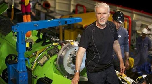
James Cameron Snags World Record For Deepest Possible Solo Dive. Pretty impressive - details from
gizmag.com: "
On March 26 at 7:52am local time, film maker/explorer James Cameron entered the history books and became the first person to visit the ocean's deepest point alone. Just two weeks ago, we reported on his previous solo-dive record of 26,791 feet (8,166m), which he handily smashed by plunging 35,756 feet (10,898m) into the Mariana Trench's Challenger Deep southwest of Guam. If the handful of contenders still vying for the record want to beat Cameron, they'll now have to excavate, because that's as deep as it gets."
A Weather Legend Passes Away. I'm very sad to pass along the sad news that AccuWeather meteorologist Ken Reeves has passed away. I knew Ken, he was an amazing meteorologist and a great all-around guy.
AccuWeather has more details: "
It is with great shock and sadness that we report fellow Expert Senior Meteorologist, Vice President and General Manager of AccuWeather, Inc. Television Network, Ken Reeves has passed away. Ken is survived by his wife Raychel, his parents, a brother and a sister. Ken and Raychel were married in October 2011. He died as a result of a tragic accident, which occurred at his home in Lemont, Pa., Sunday afternoon, March 25, 2012."
"
The fear of death follows from the fear of life. A man who lives fully is prepared to die at any time." - Mark Twain
Shorts & Jackets
"There is no such thing as bad weather - only inappropriate clothing choices."
It's perfectly acceptable to wear a stylish light jacket over your shorts. Especially this month. After a raw Monday, with a little wet snow over the far north metro (!) our Light-Switch Spring returns today. A storm tracking north of town pulls warm air north, 70 will feel pretty good.
We cool off midweek, but I don't see a big frost risk until after April 8, and even then I'm not convinced it'll be a killing freeze, at least here in the metro. The "urban heat island" effect may keep the downtowns and close-in suburbs 3-8 degrees warmer than the outlying 'burbs in early April, hopefully avoiding a debilitating freeze.
The maps are looking cooler and more volatile - a chance of significant rain around April 4-7, according to the often-more-reliable ECMWF model. I wouldn't rule out a little wet snow by mid-April nearby. (insert crickets here). I don't even want to think about that right now.
CPC predicts a warmer-than-average April, a continued warm bias to our pattern.
Tell that to folks in Chicago. The first 21 days tied for the 7th warmest APRIL on record.
A truly nutty spring/summer. It is still March, right? I suspect nature is just as confused as we are.
"
The insufferable arrogance of human beings to think that Nature was made solely for their benefit, as if it was conceivable that the sun had been set afire merely to ripen men's apples and head their cabbages." - Savinien de Cyrano de Bergerac, "Etats et empires de la lune" 1656
Climate Stories...
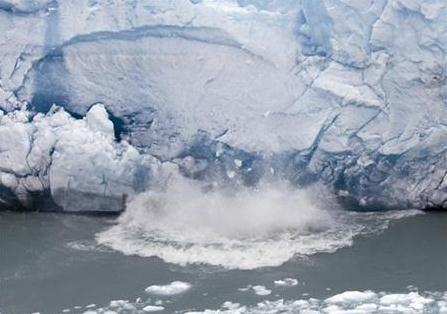
Global Warming Close To Becoming Irreversible - Scientists. Here's a lovely headline for a Tuesday. Alarmist? I sure hope so, but I'm not sure I'd bet my future grandkid's future on that.
Reuters has the story: "
The world is close to reaching tipping points that will make it irreversibly hotter, making this decade critical in efforts to contain global warming, scientists warned on Monday. Scientific estimates differ but the world's temperature looks set to rise by six degrees Celsius by 2100 if greenhouse gas emissions are allowed to rise uncontrollably. As emissions grow, scientists say the world is close to reaching thresholds beyond which the effects on the global climate will be irreversible, such as the melting of polar ice sheets and loss of rainforests." Photo: Christian Science Monitor.
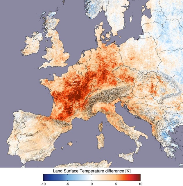
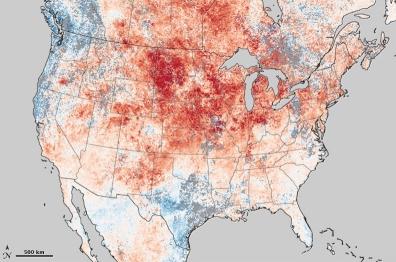
Global Warming May Have Fueled March Heat Wave Odds. Here's a timely story from Andrew Freedman at
Climate Central: "
According to several top scientists, the March heat wave that has shattered records across a wide swath of the U.S. bears some of the hallmarks of global warming. In email conversations on Wednesday and Thursday, those same scientific researchers who specialize in studying the role climate change plays in influencing individual extreme events — a burgeoning field known as "extreme event attribution” — said global warming may have made March's soaring temperatures more likely to occur, although they add that natural variability has played a key role as well."
Map credit above: "
Land surface temperature departures from average from March 8-15. Click on the image for a larger version. Credit: NASA."
Decade Of Extreme Weather Bears Fingerprint Of Climate Change. More on the possible link between a warmer, wetter atmosphere and the potential for more weather extremes from
Live Science: "
Droughts, heat waves, flooding — humanity has faced the effects of extreme, disastrous weather throughout history. But this past decade set itself apart — thanks, at least in part, to human-caused climate change, according to scientists. Last year, the United States saw 14 weather-related events that cost at least $1 billion apiece; in 2003, Europe sweltered through its hottest summer in at least 500 years; in 2010, record rainfall brought the worst flooding in Pakistan's history; and the list from recent years goes on."
Photo credit above: "
Extreme weather such as heat waves, heavy downpours and droughts are expected to accompany climate change. Recent research indicates this has begun happening. Credit: Dreamstime."
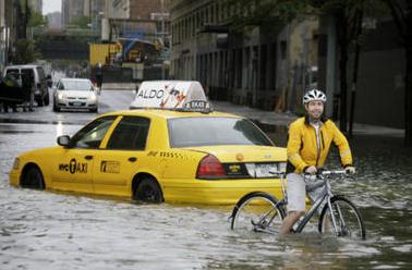
Past Decade's Extreme Weather Is Man-Made, New Study Suggests. Another angle on the latest research from the
Christian Science Monitor: "
Extreme weather events over the past decade have increased and were "very likely" caused by manmade global warming, a study in the journal Nature Climate Change said on Sunday. Scientists at Germany's Potsdam Institute for Climate Research used physics, statistical analysis and computer simulations to link extreme rainfall and heat waves to global warming. The link between warming and storms was less clear. "It is very likely that several of the unprecedented extremes of the past decade would not have occurred without anthropogenic global warming," said the study. The past decade was probably the warmest globally for at least a millennium. Last year was the eleventh hottest on record, the World Meteorological Organisation said on Friday."
Photo credit above: "
Bicyclist trudging past a stranded taxi on a New York City street flooded by the Tropical Storm Irene. The link between global warming and such storms was studied in the recent Nature: Climate Change paper." AP/Peter Morgan
Weather Records Due To Climate Change: "A Game With Loaded Dice." The story from
EurekaAlert.com: "
The past decade has been one of unprecedented weather extremes. Scientists of the Potsdam Institute for Climate Impact Research (PIK) in Germany argue that the high incidence of extremes is not merely accidental. From the many single events a pattern emerges. At least for extreme rainfall and heat waves the link with human-caused global warming is clear, the scientists show in a new analysis of scientific evidence in the journal Nature Climate Change. Less clear is the link between warming and storms, despite the observed increase in the intensity of hurricanes. In 2011 alone, the US was hit by 14 extreme weather events which caused damages exceeding one billion dollars each – in several states the months of January to October were the wettest ever recorded. Japan also registered record rainfalls, while the Yangtze river basin in China suffered a record drought. Similar record-breaking events occurred also in previous years. In 2010, Western Russia experienced the hottest summer in centuries, while in Pakistan and Australia record-breaking amounts of rain fell. 2003 saw Europe´s hottest summer in at least half a millennium. And in 2002, the weather station of Zinnwald-Georgenfeld measured more rain in one day than ever before recorded anywhere in Germany – what followed was the worst flooding of the Elbe river for centuries." Photo credit
here.
Biology: Any One Still Doubt Climate Change? Here's an excerpt of an article from
The Columbus Dispatch: "Are we there yet? If we haven’t entered a period of human-caused climate change yet, what will it take for us to agree that we have? Maybe events such as the following:
• Almost 1,500 U.S. high-temperature records fell in one week.
• Health-care specialists warn that Chagas’ disease, spread among humans by blood-sucking insects in tropical regions, might spread as temperatures rise in the United States.
• Biologists identify mechanisms by which earlier snow melts decrease populations of a rare Rocky Mountain butterfly.
• Agricultural specialists attribute global changes in crop maturation, for example early ripening of grapes, to increased global temperatures.
$20 Trillion Dollar Carbon Bubble: Interview With John Fullerton, Part 1. Brad Johnson at
Think Progress has an eye-opening article about what the ongoing climate denial is all about. There's an estimated $20 trillion worth of coal, gas and oil still in the ground - the legacy energy industry is terrified of additional regulation (related to pollution and CO2 emissions) that might prevent them from digging and drilling and burning the remaining carbon reserves. After all, they answer to shareholders, right? If the major energy industries of the world are prevented from tapping these remaining reserves - share prices and valuations would utlimately tumble. This is why the gloves have come off, with professional deniers and ongoing roadblocks and paralysis in Washington D.C. "
John Fullerton, the founder and president of the Capital Institute, sees the global economy facing the possibility of a crash that would dwarf the subprime crisis and the Great Depression. He also envisions a future where the economy is based not on consumption and competition for resources but on personal well-being. An essential finding that drives his work is what he calls the “stranded asset problem.” In an interview with ThinkProgress Green about this big choice, Fullerton explains the extraordinary challenge of the $20 trillion carbon bubble."
Impact Of Climate Change May Be Underestimated. From
The ABC Network in Melbourne, Australia: "
A new study suggests climate scientists may have underestimated the effect of greenhouse gases, with global temperatures now predicted to rise by between 1.4 and 3 degrees Celsius by 2050. The study was published in the journal Nature Geoscience by a team of international scientists who ran 10,000 computer simulations of climate models in an attempt to explore the range of global warming predictions made by climate scientists. The researchers found that while their results matched the predictions made by the Intergovernmental Panel on Climate Change (IPCC) at the lower end, they were higher than earlier predictions at the higher end."
* the paper referenced in the story above is
here, courtesy of Nature Geoscience.
Op-Ed: "There's No Politics In The Scientific Method". This commentary in
The Holland Sentinel struck a chord: "
Anyone who has actually worked as a scientist understands that the great success of modern science derives from the peer review process and its essentially adversarial nature. Errors are discovered and corrected by other scientists as they build their own careers, and eventually we arrive at the best possible explanations for natural phenomena. The notion that science is nothing more than a political philosophy is childish at best and dishonest at worst. Unfortunately, climate-change deniers like Goreham have been all too successful at convincing the willfully gullible."
Triumph, Tragedy And Climate Change: "The Island President". The story from
ThinkProgress.com: “
A cross between paradise and paradise.” This is how Mohammed Nasheed of the Maldives describes his nation in Jon Shenk’s powerful new film, The Island President. Shenk follows President Nasheed over a one-year period, leading up to the Copenhagen climate summit, in a beautiful, courageous, and strangely hopeful story. The film resonates all the more deeply following last month’s coup in the Maldives. The story’s ending — perhaps tragic, perhaps a powerful continuation — is today unfolding in real time. The Maldives is a string of 2,000 islands off the coast of India, home to about 300,000 people. The highest point in the country is only a few feet above sea level. Until 2008, the islands had been under dictatorial rule for decades."
Lawyers For Mining Companies Threaten Scientific Journals. This is a worrying development. When in doubt, litigate, right?
Slashdot.com has an overview: "
ScienceInsider got hold of a threatening letter that lawyers for the mining industry sent to various scientific journals (PDF) concerning data from the U.S. 'Diesel Exhaust in Miners Study.' Many occupational health researchers believe the study will show a link between diesel exhaust and cancer. A handful of scientists have commented on the letter and its implications." Photo credit
here.
Climate Change Brings Bats To Austin. Well here's a bit of good news; soon we'll be tracking plagues of bats crossing the U.S./Mexican border on Doppler...? This story brought to you by
The Daily Texan: "
With the emergence of warm spring weather comes the return of the Mexican Freetail bats under Congress Bridge and the remote possibility that a feared and foreign species of bat could make its way into Texas. The increase in global climate temperatures has raised concerns about the vampire bat species travelling from Mexico and South and Central America into the southern and central regions of Texas. Carin Peterson, training and outreach coordinator of the Office of Environmental Health and Safety, said even if vampire bats are not making their appearance, Austin’s surrounding caves and popular bat attraction, Congress Avenue Bridge, already have their annual bat species." Photo credit: Betsy Cooper, Daily Texan.