A Dry Cold
I
have to laugh when friends in Arizona describe a "dry heat" in the
summer. But they have a point; moisture in the air makes a big
difference. It's why 100F is tolerable in Scottsdale but horrific in Ft.
Myers.
When I tell people I'm from Minnesota they look at me like
I'm either slightly mad, or a descendent of Sir Edmund Hillary, the
first man to conquer Mt. Everest. "How do you survive out there?" The
reality: our coldest fronts blow dry (sunny) Canadian air into
Minnesota, making it almost tolerable.
The coldest I've ever been?
Chicago and Manhattan, surrounded by water - with higher humidity
levels. Damp clothes allow the chill to penetrate through layers of
clothing, making it feel much colder, much faster. It's true.
Long-range
guidance shows another shot of numbing air after December 5. Until then
Canadian air is tempered by a faint Pacific breeze, meaning highs
mostly in the 30s the next 8-10 days. Good news for Upper Midwest
travelers: a couple of scrawny clippers this week, but no
slush-potential until early next week.
An ill-timed east coast
storm dumps heavy rain east of I-95 with snow for the Appalachians the
day before Thanksgiving. Travel updates and details below.
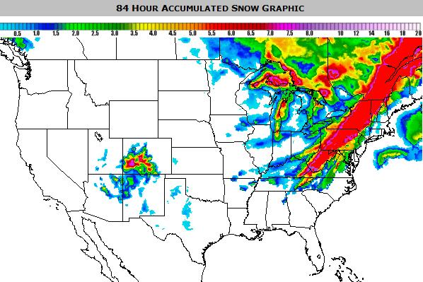
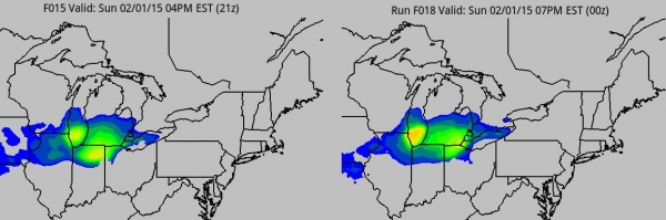
84 Hour Snowfall.
Here's a look at where heavy snow is likely Tuesday and Wednesday as a
storm pushes out into the Atlantic. The Appalachians will take the brunt
of this snowstorm, temperatures aloft warm enough for rain east of
I-95. NAM guidance: NOAA and Ham Weather.
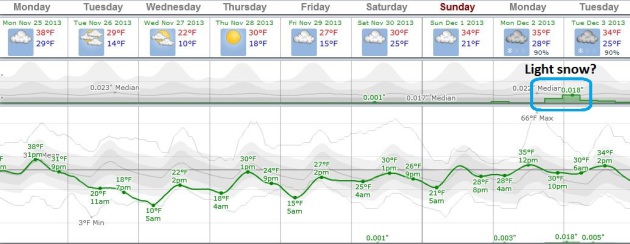
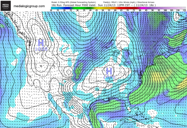
A Quiet Thanksgiving Week.
It's almost supernaturally quiet out there over the northern tier
states. No complaints - travelers within 300-400 miles of MSP will be
thanking their good fortune. We cool down agai Tuesday and Wednesday
before (slight) moderation the end of the week and weekend; a slight
chance of light snow next Monday and Tuesday. Graph: Weatherspark.
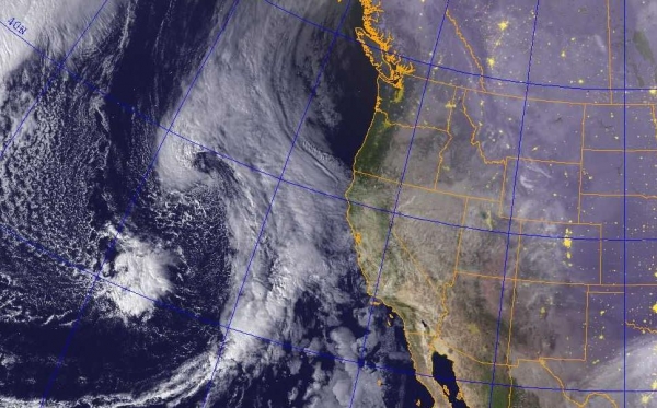
Loaded With Moisture.
The snow, ice and rain storm grinding across the south will take a turn
up the east coast by tomorrow and Wednesday, spreading a shield of
heavy rain and snow up the eastern seaboard. The storm should push
offshore in time for Thanksgiving. NAM guidance courtesy of NOAA and Ham
Weather.
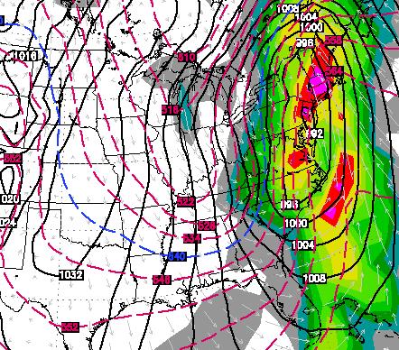
Storm Evolution.
Keep in mind the animation above shows predicted (GFS) surface pressure
and wind speeds. You can see the storm pushing out the Gulf of Mexico,
tracking right up the east coast, dumping heavy rain, especially east of
I-95. Loop: NOAA and Ham Weather.
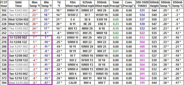
Arctic Blast Second Week of December?
I've seen a few consecutive model runs, all pulling varying shades of
bitter into MSP after December 5 or so. We could see a week with highs
in single digits and nights dipping below zero, although a lack of snow
cover MIGHT limit how low the mercury can go.
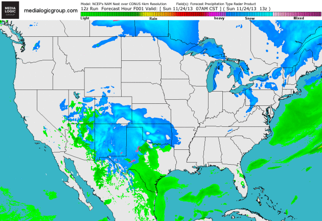
Alerts Broadcaster Briefing: Issued midday Sunday, November 24, 2013.
* Dallas/Fort Worth still on track for significant ice Sunday night into Monday morning, impacting commutes and facilities.
*
Heavy snow/ice overspreads Arkansas, northern Mississippi and Alabama
Monday into early Tuesday; a few inches of icy accumulation expected.
*
Still on track for heavy rain and urban flooding up and down the
eastern seaboard Tuesday into Wednesday; all-rain expected east of I-95,
some slush western suburbs of D.C., Baltimore, Philadelphia and New
York City, with very heavy snowfall amounts from the Shenandoah Valley
and Appalachians into central/western Pennsylvania and much of upstate
New York by Wednesday. Thanksgiving travel will be impacted/disrupted.
Lousy Timing.
A sharp contrast in air temperature coupled with the availability of
moisture from the Gulf of Mexico will fuel a developing storm capable of
impacting 80 million Americans over the next 3-4 days; tracking across
the Gulf coast before turning up the east coast Tuesday and Wednesday.
The heavy rain will taper in time for Thanksgiving Day, but heavy lake
effect snows will linger from Cleveland and Pittsburgh to Buffalo,
Rochester and Syracuse.
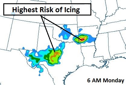
Serious Icing Concerns.
Computer models shows a significant risk of sleet (ice pellets) and
freezing rain (rain freezing on contact with cold surfaces) across much
of northern and western Texas into Sunday night, expanding into
southwest Arkansas (Hot Springs area) during the day Monday. Very icy
roads and sporadic power outages are possible in these areas. Map: NOAA.
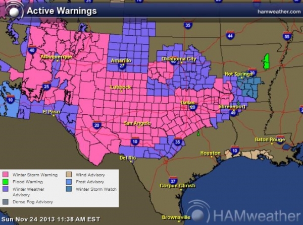
Latest Warnings.
Winter Storm Warnings are postedf from Albuquerque east to Lubbock, San
Angelo, Abilene and the Dallas metro area, with Winter Storm Watches
for Shreveport, advisories for Hot Springs and the suburbs of Little
Rock. The main surge of moisture pushes across the region later today
into midday Monday, surface temperatures cold enough for an icy, snowy
mix.
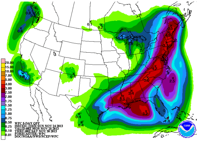
Heavy Rain Potential.
Models are consistently printing out some 2-4" rainfall amounts Tuesday
into Wednesday from Atlanta to Charlotte, Richmond, Washington D.C.,
Philadelphia and New York into Hartford and Boston - capable of urban
and small stream flooding in the days leading up to Thanksgiving. Travel
by land and air will be impacted. Map above: NOAA 5-Day Precipitation
Outlook.
Peak Of The Storm.
The same ECMWF model shows the heaviest rain (and greatest potential
for embedded T-storms) late Tuesday night into midday Wednesday in the
I-95 corridor from D.C. to Philly, New York and Boston. This is when the
potential for localized flash flooding and travel impacts will be
greatest. Map above valid noon on Wednesday. Midday Wednesday map
courtesy of WSI.
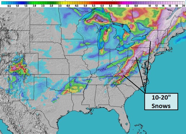
Heavy Inland Snows.
I still expect little or no accumulating snow east of I-95, but models
consistently show a few inches of slush from the western suburbs of
Washington D.C. and Baltimore to York, Lancaster and Allentown. The
Appalachians will bear the brunt of the heaviest snow, some 1-2 foot
snowfall amounts from far western Virginia and West Virginia to Altoona,
State College, Syracuse and Rochester, with the worst conditions coming
on Wednesday. I expect widespread delays and cancellations in this
region by midweek. Map: NOAA's 12km NAM and Ham Weather.
Blizzard Potential Index.
Our internal BPI model shows blizzard-conditions for much of upstate
New York Wednesday, as lake effect kicks in on cold winds on the
backside of the storm. Map: Ham Weather.
Summary:
The storm we've been tracking and briefing on for many days now is
still very much on track. Ice will impact metro Dallas and Fort Worth
tonight and Monday morning, with hazardous winter travel possible over
much of the Deep South Monday and early Tuesday, spreading up the
Appalachians by midweek. East of I-95 precipitation will fall as (heavy)
rain with a potential for urban flooding, especially Wednesday.
Plowable
amounts of snow are expected from Roanoke to Leesburg, Winchester,
Frederick, Hagerstown, York, Harrisburg, Lancaster, Reading and
Allentown into northern New Jersey. This may be a crippling snowfall for
the higher elevations from near Elkins and Charlestown, West Virginia
to Pittsburgh, State College, Elmira, Syracuse and Rochester, New York.
Pre-Thanksgiving operations will be impacted all up and down the east coast
with conditions rapidly improving on Thanksgiving Day. Yes, major
storms prefer to come on or before major holidays - the biggest travel
week is just too tempting a target, I fear. We'll keep you posted.

Why Americans And Europeans May Soon Start Dying Of Infections Like It's 1905 Again.
Antibiotics aren't keeping up with the new "super-bugs" out there. As
long as you don't get an infection or have to spend time in a hospital
you should be just fine.
Quartz has the story - here's an excerpt: "
Antibiotics
aren’t doing what they’re supposed to do anymore. You know, kill
infections. Since Alexander Fleming invented penicillin 75 years ago,
nearly all bacteria have mutated into strains impervious to antibiotics.
Those souped up bacteria now kill hundreds of thousands of people, at a
minimum, each year. And according to a new issue of medical journal The
Lancet focused on antibiotic-resistant bacteria, things could soon get a
whole lot scarier. “Rarely has
modern medicine faced such a grave threat. Without antibiotics,
treatments for minor surgery to major transplants could become
impossible…"
Photo credit above: "Slippery little suckers." Reuters/Ints Kalnins
Local TV Anchor Leaves Small Screen For Second Screen. This shows some true initiative and creativity; here's a clip from
Lost Remote: "
Jenni
Hogan was a local TV anchor in Seattle, Portland, and Idaho for 10
years, but she recently left the small screen for the second screen,
developing an app that curates viewer tweets and puts them on-air live
during broadcasts. TVinteract
is Hogan’s creation for iPad’s that allows TV personalities the ability
to pick their favorite fan tweets, and air them live on TV. How it
works is a TV personality can look at their @mentions on the left side
of the app screen, and drag the tweets they like over to the right and
hit live. This automatically flags the tweet to the show’s director, who
can then bring the tweet live to air through airplay or HDMI cable..."
The Slight Overreaction.
Who doesn't like kittens? Especially cute kittens with a lizard
phobia? This is one of 31 animated GIF's - I'd wager a stale bagel at
least one of these clips at
Buzzfeed will make you laugh.
Climate Stories....
Last Minute Deal Saves Fractious U.N. Climate Talks. The BBC has the latest; here's a clip: "
After
30 hours of deadlock, they approved a pathway to a new global climate
treaty in Paris in 2015. The agreement was achieved after a series of
last minute compromises often involving single words in draft texts.
Negotiators also made progress on the contentious issue of loss and
damage that developing countries are expected to suffer in a warming
world. Green groups were angry about the lack of specific commitments on
finance..."
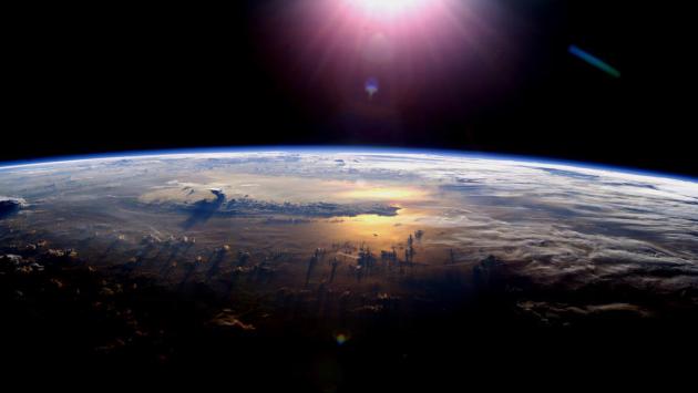
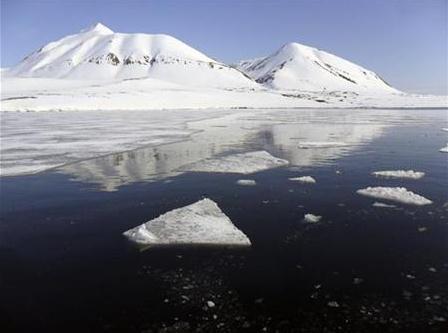
Insurance Industry Shows Concern Over Climate Change.
Extreme storms are striking with greater frequency, and rising seas are
further magnifying some of these impacts. Here is a look at how the
insurance industry is taking climate change very seriously; an excerpt
from
Insurance News Daily: "...
The insurance industry has
been warning of the increasing frequency of powerful natural disasters.
Storms that had been considered once in 100 year events are becoming
more common and there are few countries that have protection against
such devastating natural disasters. Insurers have become well aware of
the impact that these disasters can have....Swiss Re, one of the largest
reinsurance companies in the world, recently reported that severe
weather could cause some $160 billion in damage to the global economy,
only $70 billion of which is actually covered by insurance protection.
Exactly what can be done to mitigate the impact of powerful natural
disasters is uncertain, but the insurance industry is beginning to show
signs that it is taking the issue of climate change more seriously than
others." (Image: NASA).
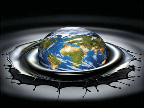
Oil's Biggest Problem? A New "Peak" Worry.
Could our need for oil actually diminish, on a global scale, as new
(less polluting) energy sources are invented? Who will be the next
Google that reinvents how we use energy? Here's an interesting twist on
the concept of peak oil at
Canada's Globe and Mail: "...
If
you’re an oil company or investor, it’s probably dawning on you that
peak oil – the point at which geology and technology dictate the maximum
rate of production, after which decline sets in – will not determine
future oil prices and, therefore, the value of your energy portfolio. So
what will? Peak demand could, and it’s a credible theory that is
gaining a following. In a recent interview, John Browne, the former
chief executive of BP, said, “Oil prices will be limited by peak demand,
not peak supply.” By that, he means the point will come when the world
simply doesn’t need ever-rising amounts of oil..."
Arctic Storms, Warming Mean More Methane Released. Scientists describe "unknown unknowns". It's what we don't know that may come back to bite us. Here's an excerpt of a
Climate Central article that caught my eye: "...
Shakhova
has spent the past decade compiling data on the East Siberia Arctic
Shelf through research cruises and flyovers of the region. She published initial results in 2010,
which showed that methane has been escaping at hot spots where vents
have formed from a combination of geothermal heat as well as warmer
river water flowing into the region. Those results showed that 7
teragrams of methane is bubbling to the surface annually. That's roughly
the equivalent of 10 percent of the methane emissions from U.S. oil and
natural gas production and transmission in 2012. The new research
refined those results, showing the amount of methane reaching the
surface is more than double those previous estimates. In all, Shakhova
and her colleagues estimate that 17 teragrams are escaping each year,
though the new study says the estimates are likely on the conservative
end. Shakhova said those totals are on par with emissions from the
Arctic tundra..." (Photo image: World Bulletin).
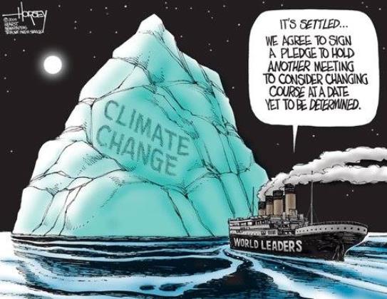
It's Settled. Cartoon courtesy of
David Horsey.
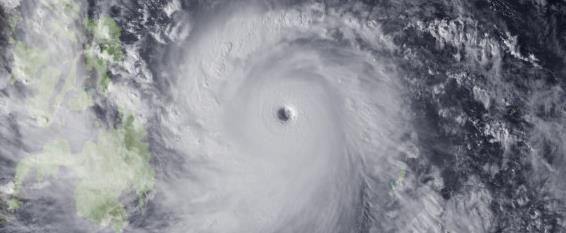
Americans Are Convinced Climate Change Is Connected To Stronger Storms, Poll Says. Here's an excerpt from a story at
Huffington Post: "
Most Americans think climate change, and more frequent and severe natural disasters are linked, according to a new HuffPost/YouGov poll
that also finds most think human activity is at least partially
responsible for the changing climate. According to the new poll,
conducted after Typhoon Haiyan devastated the Philippines earlier this
month, 55 percent of Americans think climate change is related to more
frequent and severe natural disasters, while only 23 percent do not..."
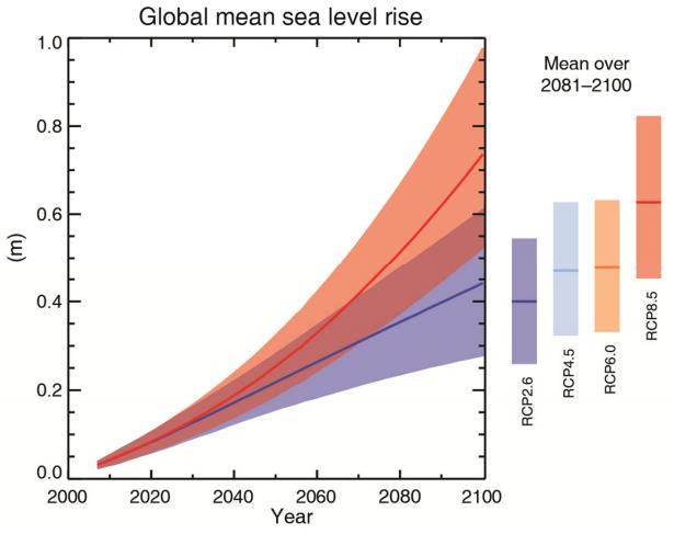
Sea Level Experts Concerned About "High-End" Scenarios. Andrew Freedman has the story at
Climate Central; here's the introduction: "
A survey of nearly 100 experts on sea level rise
reveals that scientists think there is a good chance the global average
sea level rise can be limited to less than 3.3 feet by 2100 if
stringent reductions in planet-warming greenhouse gases are rapidly
instituted. However, the survey, which is the largest such study of the
views of the most active sea level researchers ever conducted, found
that if manmade global warming were to be on the high end of the scale — 8°F by 2100 — the global average sea level is likely to jump by between 2.3 and 3.9 feet by the end of this century..."
Graphic credit above: "
Projections
of global mean sea level rise over the 21st century relative to
1986–2005 from the combination of the computer models with process-based
models, for greenhouse gas concentration scenarios. The assessed likely
range is shown as a shaded band." Credit: IPCC Working Group I.
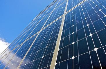
A Warm Over Solar Power Is Raging Within The GOP. New Republic
has the story of what's happening in Arizona, disruptive technology
that has many homeowners enthused, but utilities nervous, and that's
creating friction. Here's an excerpt: "... “
Republicans who oppose
solar in the next election, they are going to be wiped out across the
board.” “Solar power is philosophically consistent with the Republican
Party,” Rose added. “If you're going to be for healthcare choice and
school choice, how can you not be for energy choice? Conservatives,
overwhelmingly, get that. If the Republican Party stops standing for the
empowerment of the individual, what does it stand for?” (Image: Mike Baker, Creative Commons).