10.5" snow fell at Milroy, Minnesota Tuesday.
 Limping into Winter
"You
can prove anything with statistics" my father warned me. Amen.
Minnesota's weather is rarely "average" - we usually ricochet from one
extreme to the next. The median date of the first 1 inch snow at MSP is
November 18. But the first inch has come as early as September 26
(1942), as late as January 9 (1945). There's no rhyme or reason.
1.1
inches of slush fell at MSP International Tuesday night, but most of
that melted on contact. Amazingly, no weather models take soil
temperatures into account. It's hard to get accumulating snow when you
start the day in the mid-40s. But farther north & west it was 5-8F
colder, allowing a whopping 10.5 inches to accumulate at Milroy,
Minnesota. Yes, November snows are especially fickle.
This is why my ulcers have ulcers.
Welcome
to a drama-free weather zone, at least into the weekend. We warm into
the 40s over the weekend; PM rain showers Friday in the Twin Cities -
maybe a coating to an inch of slush far north to help with tracking for
Saturday's Deer Hunting Opener.
A much colder front is brewing
next week with highs from 25-35. Temperatures moderate by the third week
of November - jet stream winds aloft howling from Seattle, instead of
the Yukon.
I'm OK with that.
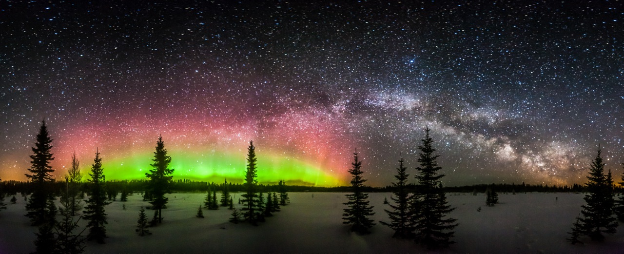
* Amazing aurora photo above courtesy of
Steve Burns Photography.
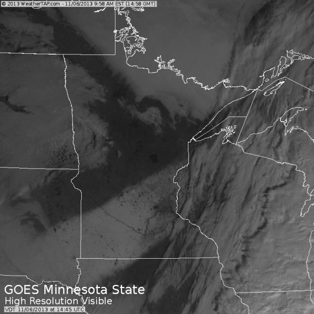
Snowy Swath.
Yesterday's visible satellite loop from NOAA showed the band of snow
from Tuesday night's fast-moving wave of low pressure - amounts heaviest
over southwest Minnesota, where some 3-8" amounts were reported. Note
the melting by early afternoon, especially over the Twin Cities metro,
where the urban heat island accelerated warming.
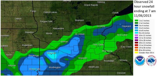
Snowfall Totals.
Here's a good summary of how much snow fell Tuesday and Tuesday night;
heaviest amounts near Marshall, 2-3" on the south side of St. Cloud.
Source:
Twin Cities National Weather Service.
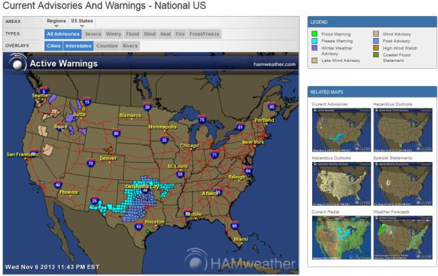
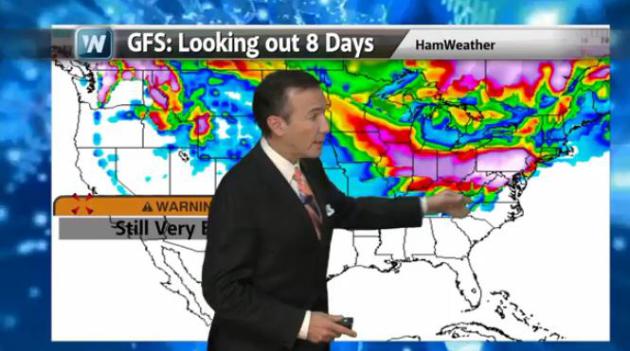
Current Weather Watches, Warnings & Advisories. If you're doing any traveling in the coming weeks leading up to Thanksgiving
click here to see the latest national and regional advisories, courtesy of Ham Weather.
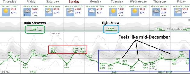
No Huge Surprises.
After holding in the upper 30s today the mercury SOARS to 40-ish Friday
(with a few PM rain showers), low to mid 40s over the weekend before a
temperature tumble next week. A clipper may brush portions of Minnesota
on Tuesday. Graph: Weatherspark.
Some Moderation Third Week Of November?
The models have been all over the map, so my confidence level is lower
than usual, but there's a fair amount of guidance suggesting a
Pacific/zonal flow returning in about 2 weeks, with highs in the 40s to
near 50F.
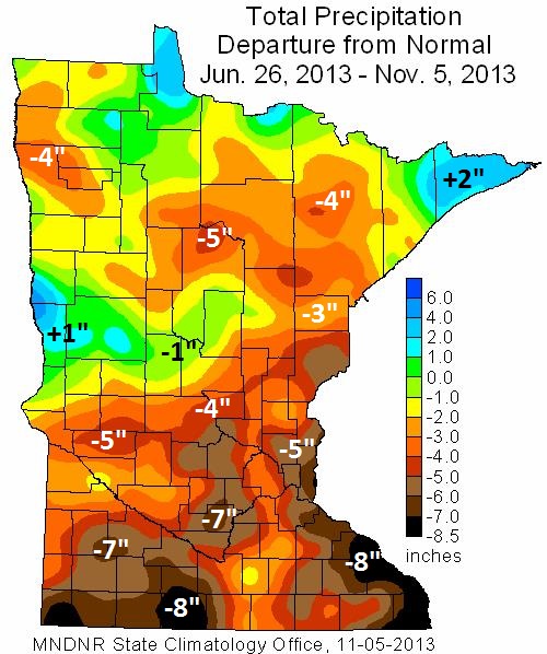
October Recap.
The map above shows precipitation anomalies from June 26 to November 5,
a dry bias for most of Minnesota. The far western and eastern suburbs
of the Twin Cities are running a 5-6" rainfall deficit since late June,
an 8" rainfall shortfall for parts of southwest and far southeast
Minnesota. Only a small sliver of west central Minnesota and the North
Shore has seen wetter than average conditions during this same period.
Here's a review of October, courtesy of the
Minnesota DNR and the Minnesota Climatology Working Group:
- October
precipitation totals were above historical averages in most Minnesota
counties. For many Minnesota locales, October precipitation totals
exceeded long-term averages by an inch or more. In some central and
southeast Minnesota communities, monthly precipitation totals topped
historical averages by two or more inches and eased drought concerns in
those areas.
- Two to six inches of rain fell on portions of
southeast Minnesota on October 4 and 5, leading to mudslides, road
washouts, and urban flooding.
- The U. S. Drought Monitor places
large sections of the southern one-half of Minnesota, and a small area
of northwest Minnesota in the Moderate Drought category. Roughly one-quarter of the state is designated as undergoing Moderate Drought. This is an improvement over early October when nearly 40 percent of Minnesota's landscape fell in the Moderate Drought or Severe Drought categories.
Historical Thanksgiving Day Weather - And The GFS Says What? Late November can bring everything from blizzards to tornado outbreaks. In today's edition of
Climate Matters we recap memorable storms, and take a look at an eye-popping GFS snow forecast for the Mid Atlantic Region. I have my doubts: "
WeatherNationTV
Chief Meteorologist Paul Douglas is already thinking about
Thanksgiving. Turkey dinners, family, football, and tornadoes? It's
possible. Significant weather events on Thanksgiving range from
blizzards to howling winds to tornado outbreaks. Also, the GFS is
letting lose with a deluge of snow for the Mid-Atlantic. Take it with a
grain of salt."
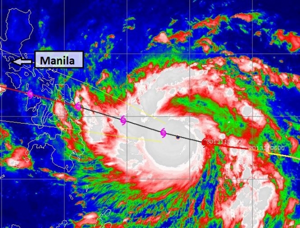
A Storm To Rival "Pablo"?
Pablo devasted portions of the Philippines in December, 2012, sparking
over 1,000 deaths and extensive damage. "Haiyan" is a comparable storm,
forecast to impact the central Philippines Friday (local Manila time).
Here's an excerpt of an
Alerts Broadcaster briefing that went out yesterday:
* Super Typhoon Haiyan estimated to have reached Category 5 strength, with sustained winds of 160 mph, gusts to 190 mph.
*
Slight weakening is possible before Haiyan comes ashore over the
central Philippines Friday (local Manila time), but this will probably
be the most destructive typhoon of the year for the Philippines,
possibly the strongest in several years.
Extreme damage and significant loss of life is possible with this
storm, mainly over the central Philippines, the eastern coast of
southern Luzon and the Samar Islands. The island nation of Palau may
take a direct and devasting hit from Haiyan.
* The core of
strongest winds, heaviest rains and highest storm surge will pass south
of Manila during the day Friday and Friday night, local time, with only
minor to moderate impacts for the capital city.
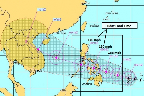
Super-Storm.
"Haiyan" is the strongest storm I've seen yet this year in the western
Pacific, factoring wind speed and the size of the wind field. Sustained
winds are 160 mph with gusts to 190; this powerful Category 5 typhoon
(same thing as a hurricane) whipping up 48 foot seas as it tracks to the
west-northwest.
Timing Haiyan.
The Navy's JTWC, or Joint Typhoon Warning Center, has Haiyan reaching
the central Philippines during the day Friday (local time) as a severe
Category 4-5 storm, capable of an extreme 20-25 foot storm surge,
sustained winds over 150 mph, and as much as 15" rain, capable of
extensive flooding and mudslides. The core of the storm passes 150-200
miles southwest of Manila late Friday and Friday night, Manila time,
brushing the capital with winds gusting to 50-60 mph and minor to
moderate flooding as the outer bands of this system pass just south.
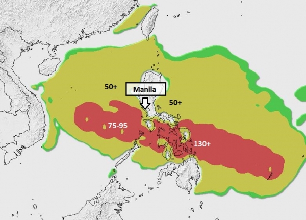
Predicted Wind Swath.
Our internal models show the most damaging winds with Super Typhoon
Haiyan tracking (just) south of Manila Friday PM hours (local time).
Winds may top 140 mph in the central Philippines, but I expect gusts no
higher than 50-60 mph in downtown Manila at the height of the storm
Friday PM hours.
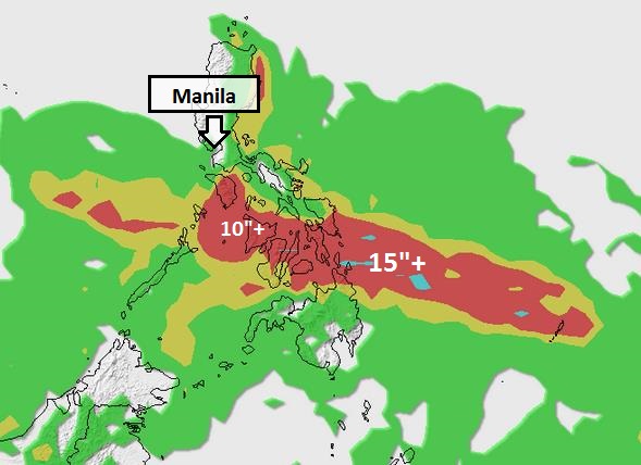
Rainfall Estimates.
Right now the GFS model keeps the band of heaviest (10-15") rains just
south of Manila. Severe river and flash flooding and mudslides are
likely over the central Philippines, but on it's current trajectory I
expect only minor to moderate urban flooding in Manila. Keep in mind
soils are already saturated across much of the Philippines from recent
heavy rains. Haiyan will add insult to injury.
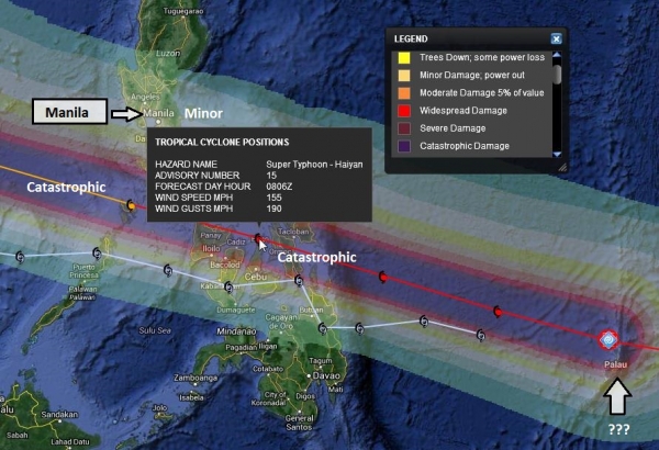
Damage Path.
Potentially catastrophic wind damage is possible over the central
Philippines, from Tacloban to Roxas and Kalibo. Latest models show winds
close to 145-155 mph at landfall Friday morning, local time. I'm very
concerned about Palau, which will see a direct strike from Haiyan. Much
of the island is close to sea level, and storm surge damage may be
extensive, possibly extreme.
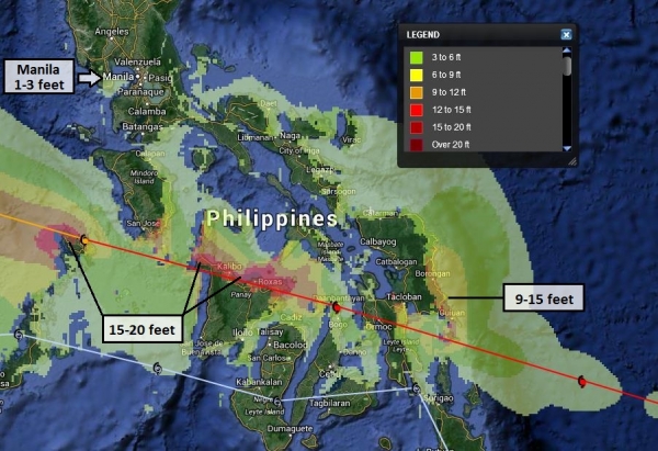
Predicted Storm Surge.
The good news: only a 1-3 foot storm surge is projected for Manila Bay
on Friday (local time). But the central Philippines will see Haiyan's
full fury, with a potential for a 15-20 foot surge from Roxas City to
San Jose and Coron. Any slight northward jog in the storm track could
bring a significant storm surge into Manila Bay - something we need to
watch carefully over the next 24 hours.
Summary:
an especially dangerous typhoon is bearing down on the central
Philippines, capable of extreme damage and potential loss of life. The
greatest concern is storm surge, the sudden rise in sea level as the eye
of the storm passes nearby, as much as 15-20+ feet for some coastal
communities well south of Manila. A secondary concern is damaging winds,
strongest on the coast at landfall, near Guiuan and Borongan City early
Friday, local time. 10-15" rains will trigger extensive inland flooding
and mudslides - widespread power outages are likely. I'm concerned
about aftermath; a significant risk of disease and even civil unrest, in
the wake of what will probably be the most destructive typhoon to hit
the Philippines in many years. We'll keep you posted.
Paul Douglas - Alerts Broadcaster

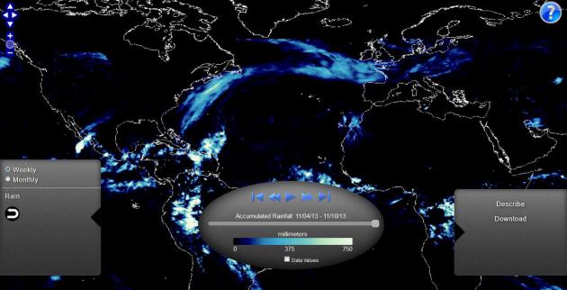
NOAA View Data Imagery Portal (beta). Here's a
new tool for visualizing data, worldwide. Thanks to Capital Weather Gang for bringing this to my attention: "
NOAA
View provides access to maps of NOAA data from a variety of satellite,
model, and other analysis sources. NOAA View is intended as an education
and outreach tool, and is not an official source of NOAA data for
decision support or scientific purposes."
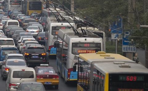
Smog Blamed As Girl, 8, Becomes Youngest Lung Cancer Patient. Good grief - remind me not to visit China without a state-of-the-art gas mask. Here's an excerpt from a sobering article at
The South China Morning Post: "
An
eight-year-old girl has become the mainland's youngest lung cancer
patient, with her illness blamed directly on environment factors. The
girl from Jiangsu lived by a busy road where she inhaled all kinds of
dust and particles, China News Service cited Dr Feng Dongjie of Jiangsu
Cancer Hospital as saying. These included superfine PM2.5 particles,
less than 2.5 microns wide, that are considered the most dangerous
component of smog, Feng said. The country's breakneck urbanisation and
industrialisation has created some of the world's worst urban pollution,
which is blamed for soaring rates of cancer and respiratory diseases..."
Photo credit above: "
China's breakneck urbanisation and industrialisation has created some of the world's worst urban pollution." Photo: AP.
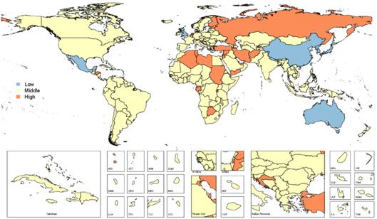
It's A Sad, Sad, Sad, Sad World. Depression And Global Disability. Yes, it could be worse, you could be living in Afghanistan.
The Los Angeles Times has the story - here's an excerpt: "
Clinical depression
is now the second-leading cause of global disability, according to new
research, with the highest rates of incidence affecting working-age
adults and women more than men. In a paper
published Tuesday in the journal Plos Medicine, researchers found that
depressive disorders were second only to lower respiratory infections
when it came to inflicting the most years of disability on people
throughout the world. Rates of depression were highest in Afghanistan
and lowest in Japan, while the condition ranked as the top cause of
disability in Central America and Central and Southeast Asia..."
Map credit above: "
A
new study reports that depression is the second-leading cause of global
disability. This map shows nations with a statistically lower rate of
depression disability in blue, middle-ranking rates in yellow and high
rates in orange. Rankings are relative to global mean rate of years
lived with disability."
(Plos Medicine / November 5, 2013).
How The Way We Walk Can Increase Risk Of Being Mugged. Here's a clip from
The BBC: "
How
you move gives a lot away. Maybe too much, if the wrong person is
watching. We think, for instance, that the way people walk can influence
the likelihood of an attack by a stranger. But we also think that their
walking style can be altered to reduce the chances of being targeted. A
small number of criminals commit most of the crimes, and the crimes
they commit are spread unevenly over the population: some unfortunate
individuals seem to be picked out repeatedly by those intent on violent
assault..."
Photo credit above: "
Man walking in tunnel." (Stig Nygaard/Flickr).
The Science Of Why You Hate Your Daughter's Boyfriend. The things you learn on this-here-interweb-thingy. Here's a clip from a story at
NewStatesman: "...
Two scientists have come up with an evolutionary argument. In a study published in the journal of Evolution and Human Behaviour,
Franjo Weissing and Bram Buunk argue that it all stems from children
trying to get money out of their parents. To show this, they built a
computer model detailing a vast fictional population. The men had
different abilities to provide for future children, and women had
varying strengths of preference for this trait..."
Toyota's Hyper-Radical FV2 Concept Pushes Personal Transportation Boundaries. A robotic, fully-enclosed motorcycl? It defies simple description - details from
Gizmag: "
Toyota's
already bold pursuit of new vistas in the realm of personal
transportation took another quantum leap forward today, when the
Japanese giant released details of the FV2, a concept car more closely
related to the Kirobo humanoid communication robot than any vehicle currently on public roads..."
Climate Stories....
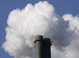
Greenhouse Gas Emissions Reached New High In 2012, World Meteorological Organization Says. CO2 emissions actually came down in the USA, but increased significantly in China and India. Here's an excerpt from Reuters and
Huffington Post: "
Atmospheric
volumes of greenhouse gases blamed for climate change hit a new record
in 2012, the World Meteorological Organisation (WMO) said on Wednesday.
"For all these major greenhouse gases the concentrations are reaching
once again record levels," WMO Secretary-General Michel Jarraud told a
news conference in Geneva at which he presented the U.N. climate
agency's annual Greenhouse Gas Bulletin. Jarraud said the accelerating
trend was driving climate change, making it harder to keep global
warming to within 2 degrees Celsius, a target agreed at a Copenhagen
summit in 2009..."
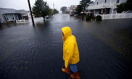
New York, London and Mumbai: Major Cities Face Risk From Sea Level Rises.
Too alarmist? We'll see, but here's the thing: this isn't about climate
models projecting out 50 years into the future. Sea level rise is a
documented reality. Since 1750 the water in New York Harbor has risen
about 15". The only question is how much higher, and how quickly. Here's
a clip from
The Guardian: "...
Strauss'
analysis only looks at the likelihood coastal cities will be under
water. Strauss forecasts the impact of rising seas without storms. He
doesn't forecast the likelihood that calamitous weather events like
Hurricane Sandy will cause far greater damage when the oceans have risen
closer to the level of the cities, overwhelming roads, sewers,
underground trains, and water systems. We can now imagine a day when
storms do not merely damage coastal cities but destroy them. He contends
that by 2100, more than 25% of Boston, Miami, New Orleans, and Atlantic
City could be under water. The same forecast (23 ft or 7m by 2100) can
be plugged into a global map of elevations and sea levels here.
Such a calculation is even more alarming. Most of the globe's economic
activity is funneled through cities that will be fighting to stay above
water. Imagine a world without Shanghai, Mumbai and Boston, a world in
which London and New York are risky settings for markets..."
Photo credit above: "
Ben
Strauss, Climate Central predicts that by 2100, more than 25% of
Boston, Miami, New Orleans, and Atlantic City could be under water." Photograph: Alex Brandon/AP.
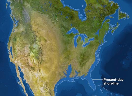
If All The Ice Melted.
Not likely to happen anytime soon, but you will see increasing pressure
along the world's coastlines in the years to come. Here's an excerpt
from an eye-opening interactive map from
National Geographic: "
The
maps here show the world as it is now, with only one difference: All
the ice on land has melted and drained into the sea, raising it 216 feet
and creating new shorelines for our continents and inland seas. There
are more than five million cubic miles of ice on Earth, and some
scientists say it would take more than 5,000 years to melt it all. If we
continue adding carbon to the atmosphere, we’ll very likely create an
ice-free planet, with an average temperature of perhaps 80 degrees
Fahrenheit instead of the current 58."
Interactive map credit
above: Jason Treat, Matthew Twombly, Web Barr, Maggie Smith, NGM staff.
Art: Kees Veenenbos. Sources: Pilippe Huybrechts, Vrije Unversiteit
Brussel, Richard S. Williams, Jr. Woods Hole Research Center, James C.
Zachos, Universoty of California, Santa Cruz, USGS, NOAA, ETOP01
Bedrock, 1 arc-minute global relief model copyright September 2013
National Geographic Society.
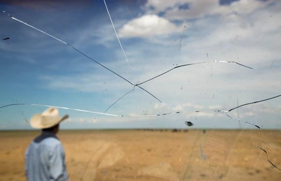
Why Even California Can't Stop Catastrophic Climate Change.
Quartz has the story - here's the introduction: "
For climate change optimists, California is indeed the golden state when it comes to aggressive policies designed to avoid catastrophic climate change. But as a new report makes depressingly clear,
even Ecotopia will fall far short of hitting a target of reducing
greenhouse gas emissions 80% by 2050 without the invention of new
technologies and imposition of more draconian green mandates. That’s
the number scientists believe must be met to keep climate change in
check. And if California can’t meet such a mandate, what nation can,
given the inability of governments to even to agree to take the most
tentative steps to reduce greenhouse gas emissions?..."
Photo credit above: "If even the Golden State can't pull off needed carbon cutting, expect more scenes like this." AP Photo/Mark Schiefelbein.
Can Attacking Scientists Be A Political Liability? Michael Halpern has the article (and possible implications of the Virginia governor's race) at
The Union of Concerned Scientists; here's the intro: "
Politicians attack scientists to score points with voters and their backers, whether it’s members of Congress attacking individual government grantees or belittling scientists whose research undermines their legislative priorities. It got so bad that UCS put out a guide for scientists
who find their work under an unusual amount of scrutiny (still a good
idea to take a look before you’re in that situation). But yesterday’s
election in Virginia may showcase how these sorts of attacks can
backfire, making a candidate look extreme and out of touch. For those
who haven’t followed the case, a recap: former University of Virginia
scientist Michael Mann is responsible for pioneering climate change
research that has since been reaffirmed by scores of researchers and
scientific bodies. Virginia Attorney General Ken Cuccinelli thought he
knew better. He made headlines around the world by issuing subpoenas to
UVa under the Virginia Fraud Against Taxpayers Act for Mann’s personal
emails and other documents (The scientist subsequently wrote a book about being raked over the coals by Cuccinelli and other politicians)..."
Virginia Governor's Race Shows Global Warming Science Denial Is A Losing Political Stance. Here's an excerpt from a
Guardian article posted by St. Thomas professor and climate scientist John Abraham: "...
Ken
Cuccinelli has a history of not only discounting scientists but
spending taxpayers' money to actively attack them. In 2010, he began a
witch hunt and accused climate scientist Dr. Michael Mann of fraud. In
the end, Cuccinelli's crusade wasted hundreds of thousands of
hard-earned taxpayer dollars – waste that Virginia voters did not
forget. As Dr. Mann himself, who campaigned for Terry McAuliffe, says,
"As discussed in some detail in my recent book The Hockey Stick and the Climate Wars,
Ken Cuccinelli, as a newly minted Attorney General of Virginia, back in
early 2010, engaged in what The Washington Post called a "witch hunt"
against me and the University of Virginia. He sought to abuse his
authority as attorney general by demanding all of my personal emails
from the six years I was a faculty member at the University of Virginia..."
Photo credit above: "
Terry McAuliffe made climate realism a big part of his campaign, and won yesterday's election to become Virginia's new governor." Photograph: Reuters.
Climate Change Puts 5 Million Israelis At Risk Of Severe Flooding Events. Here's a clip from a story at
The Jerusalem Post: "
Rising
temperatures and climbing sea levels due to climate change could be
putting more than five million Israelis at severe risk, a special
Environmental Protection Ministry report has indicated. The rise of the
Mediterranean Sea’s levels as well as the flooding of rivers could
gravely impact five million Israelis as water barrels into their
communities, the study warned. In addition to the flooding dangers, the
conditions could also result in outbreaks of transmissible diseases from
pests such as mosquitoes, the report explained. Escalating temperatures
combined with population growth will also undoubtedly lead to an
increased demand for water from decreasing aquifer supplies, it said..."
Photo credit above: "
A storm touches down on water off Atlit coast." Photo: Baz Ratner / Reuters
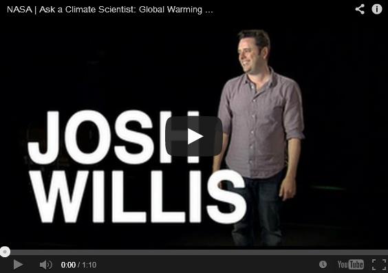
No, We Are NOT In A Climate "Pause".
Slate has the video and article; here's an excerpt: "...
One argument Hank brings up (at the 1:44 mark),
and one I’ve hammered on a few times as well, is this idea that we’re
in some sort of global warming pause. This is a claim that gets some
traction, because when you look at land surface temperatures over the
past few years, they haven’t gone up as quickly as they have in the
past. However, using this measurement to claim that global warming has
stopped, or even just paused, is wrong. The good folks at NASA Goddard
recently posted a video interview with climate scientist Josh Willis to put this claim to rest..."
Is It Too Late To Prepare For Climate Change? Here's an excerpt from an Elizabeth Kolbert article at
The New Yorker: "...
Promoting
“preparedness” is doubtless a good idea. As the executive order notes,
climate impacts—which include, but are not limited to, heat waves,
heavier downpours, and an increase in the number and intensity of
wildfires—are “already affecting communities, natural resources,
ecosystems, economies, and public health across the Nation.” However,
one of the dangers of this enterprise is that it tends to presuppose, in
a Boy Scout-ish sort of way, that “preparedness” is possible. As we
merrily roll along, radically altering the planet, we are, as the leaked
I.P.C.C. report makes clear, increasingly in danger of committing
ourselves to outcomes that will simply overwhelm societies’ ability to
adapt..."