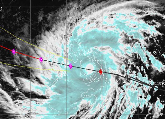
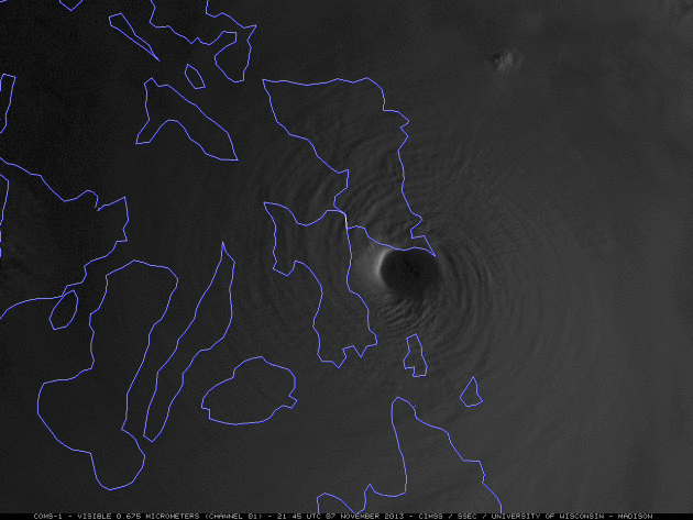
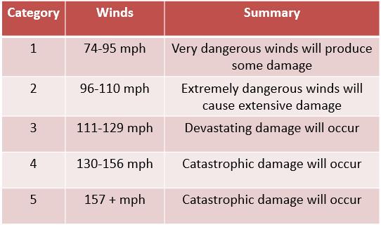
Category 6?
If the Saffir Simpson scale for measuring hurricane intensity
permitted, "Haiyan" might qualify as a rare Category 6 storm. It came
ashore Thursday evening (Friday morning local Manila time) with
sustained winds of 195, gusts to 235, a central pressure below 26" of
mercury (880 mb). According to Dr. Jeff Masters at Weather Underground
Haiyan was the strongest landfalling tropical cyclone on record.
Surreal. More details below. Satellite loop:
CIMSS, University of Wisconsin.
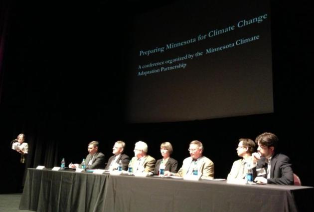
The Trees Are Confused
I
come from a long line of German foresters, so maybe there's something
in my DNA. At the first ever Minnesota Climate Adaptation Conference,
held at the Science Museum yesterday, Lee Frelich, from the University
of Minnesota Dept. of Forest Resources, said something that got my
attention. "On the drive to St. Paul I noticed green leaves on deciduous
trees. It's the latest I've ever seen this."
He showed a graphic
that said "It is possible that the prairie-forest border will move 300
miles to the north & east by 2100, placing the BWCA on the prairie
border."
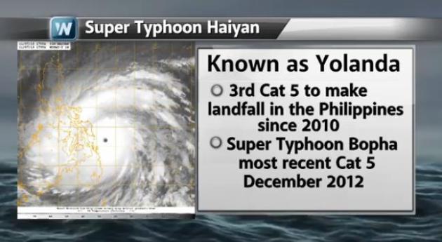
Another fingerprint, as one of the most powerful typhoons
ever observed (190 mph sustained winds, gusts to 235) devastates the
central Philippines today. It's the 3rd Category 5 typhoon to make
landfall there since 2010.
Kind of puts our annoyingly cool breeze
into perspective. A few rain showers may pop up later today; maybe an
inch of slush far northern Minnesota tonight to help with tracking for
Saturday's Deer Hunting Opener.
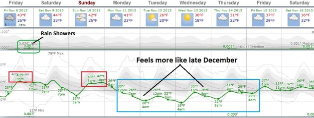
A cold front is still on track for next week - for about 4 days it'll feel like late December.
No big storms in sight here, but this surge of NUMB may spark snow, rain and beach erosion along the east coast.
Quiet Weekend, Then Dig Out The Coats.
We should see low 40s today, again Sunday, maybe mid-40s on Saturday,
before a noticeable temperature tumble next week. Not exactly "arctic
air", but highs will hold in the upper 20s to mid-30s from Tuesday into
Friday, lows dipping into the upper teens and low 20s in the metro.
Chilly enough. Graph: Weatherspark.
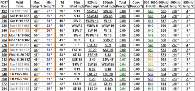
Some Moderation Third Week Of November.
The GFS has been fairly consistent pulling Pacific air back into
Minnesota; highs reaching the 40s the weekend of November 16-17,
possibly a few days above 50F within 2 weeks or so.
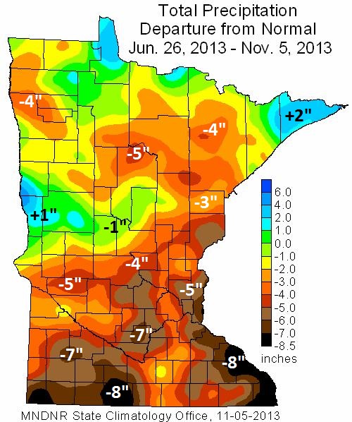
October Recap.
The map above shows precipitation anomalies from June 26 to November 5,
a dry bias for most of Minnesota. The far western and eastern suburbs
of the Twin Cities are running a 5-6" rainfall deficit since late June,
an 8" rainfall shortfall for parts of southwest and far southeast
Minnesota. Only a small sliver of west central Minnesota and the North
Shore has seen wetter than average conditions during this same period.
Here's a review of October, courtesy of the
Minnesota DNR and the Minnesota Climatology Working Group:
- October
precipitation totals were above historical averages in most Minnesota
counties. For many Minnesota locales, October precipitation totals
exceeded long-term averages by an inch or more. In some central and
southeast Minnesota communities, monthly precipitation totals topped
historical averages by two or more inches and eased drought concerns in
those areas.
- Two to six inches of rain fell on portions of
southeast Minnesota on October 4 and 5, leading to mudslides, road
washouts, and urban flooding.
- The U. S. Drought Monitor places
large sections of the southern one-half of Minnesota, and a small area
of northwest Minnesota in the Moderate Drought category. Roughly one-quarter of the state is designated as undergoing Moderate Drought. This is an improvement over early October when nearly 40 percent of Minnesota's landscape fell in the Moderate Drought or Severe Drought categories.
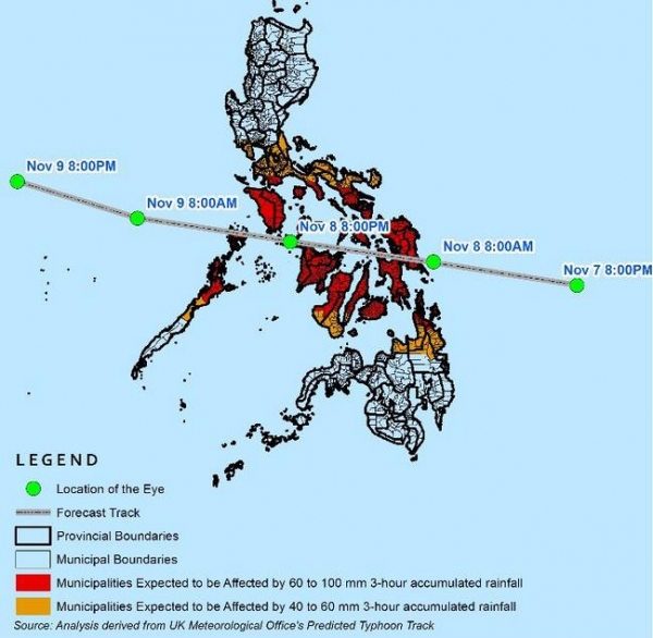
Typhoon Haiyan Storm Surge Forecast. Details: "
The
above model is a 96-hr storm surge forecast generated using Japan
Meteorological Agency (JMA) numerical model. The model covers 12:00mn of
6 November 2013 to 06:00 am of 10 November 2013 (UTC). The legend indicates storm surge height in centimeters.
A storm surge is a rise in the water level over and above the predicted
astronomical tide due to the presence of the storm. For more details on
specific coastal storm surge level details, please visit Project NOAH Website and look into the Weather Stations option, and click the YolandaPh Storm Tide Level."
Alerts Broadcaster Update: Issued Thursday night, November 7, 2013.
*
Super Typhoon Haiyan now thought to be the most powerful landfalling tropical cyclone ever observed.
It came ashore early Friday morning (local time) with 195 mph sustained
winds, gusts to 235. The area around Tacoloban City and Guiuan appears
to have taken the brunt of this historic typhoon - no contact has been
received from these towns for 3-4 hours.
* The brunt of Haiyan is
still forecast to pass south of Manila, but the capital city will be
brushed by outer bands of 50+ mph winds and torrential rains capable of
5"+ rains, which will spark minor to moderate urban flooding into
Saturday morning, local Manila time.
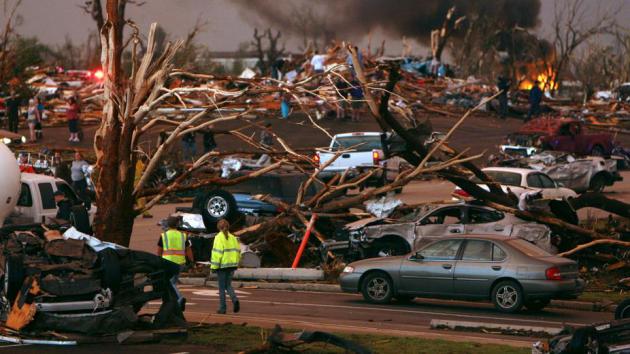
* I'm expecting damage across the central Philippines to be severe to extreme to catastrophic,
with a 100-125 mile-wide band of near total devastation.
Survivors will have to grapple with access to food and clean water -
the risk of disease and civil unrest is still high, long term.
*
Update from the Alerts Broadcast Storm Center:
Haiyan has made 4 landfalls so far, but that is to be expected with
such a large island chain. Cebu City, the "second city" of the
Philippines was brushed. Still no confirmation on that 858 reading.
Storm surge in Tacloban City of 17 ft in 30 minutes. As of right now
millions are in storm shelters. The area affected is one of the poorest
parts of the Philippines. Winds have decreased very slightly to 185 MPH
with gusts to 224 MPH.
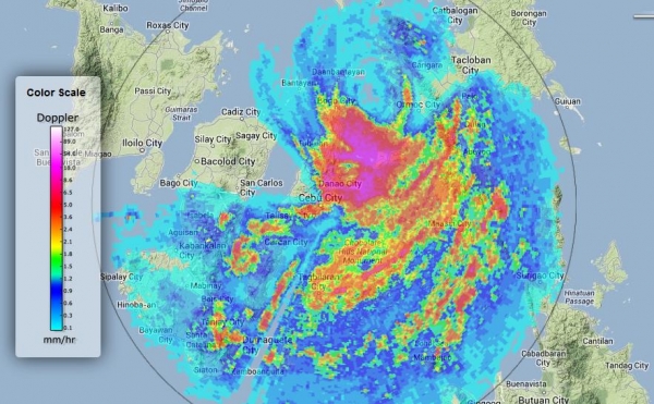
Doppler Radar.
Haiyan is still producing sustained winds close to 170-180 mph, still
an extreme Category 5+ typhoon capable of widespread damage.
Provinces Most Impacted.
The areas that we're most concerned about, where damage will range from
extensive to extreme, are from Samar and Biliran to Leyte, Biliran,
Masbate, Romblon, and Mindoro (later Friday, local time).
Manila: Brushed By Heavy Rain.
Some 3-5" rainfall amounts are possible in Manila late Friday into
Saturday morning, local time, as the center of a still powerful typhoon
passes some 200 miles southwest of the Philippine capital. Some urban
flooding is possible, but right now we expect the greatest risk of flash
flooding, river flooding, mudslides and power outages to stay (just)
south of Manila.
Philippine webcams:
http://www.mycam-asia.tv/cams/philippines/visayas/ariels_house_boracay/display_current.php
http://boracaylive.com/boracay-beach-live-camera/
http://www.bbboracay.com/cam/cam.php
http://www.bluepoint.li/beach.jpg
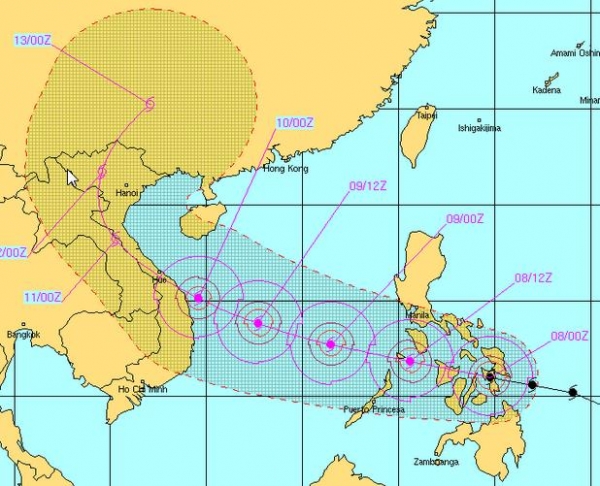
Extended Track Projections.
Typhoon Haiyan (called "Yolanda" in the Philippines - Haiyan is the
international name) will still pack 160-190 mph winds as it passes
Mindoro Friday night (local time). The typhoon is forecast to retain
much of its power, reaching Vietnam south of Hue Sunday morning with
sustained winds of 120-140 mph. Map: JTWC, Joint Typhoon Warning Center.
Shifting gears...
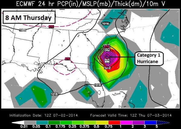
Nor'easter Potential Next Week.
The map above is from the European (ECMWF) model, valid next Thursday
morning at 6 AM. A surge of Canadian air is forecast to spin up a
significant coastal storm, capable of inland snows, heavy rains east of
I-95, and sustained winds of 25-40 mph, capable of significant coastal
flooding from The Outer Banks to New Jersey and Long Island the latter
half of next week. Atlanta may see a cold rain changing to wet snow
Wednesday PM hours, with a potential for some slushy accumulation over
northern Georgia. We'll have to watch this carefully. Map: WSI.
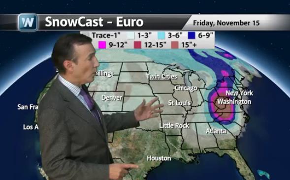
Heavy Snow Potential.
I've gone on record saying any forecast beyond 7 days is more of a
horoscope than a prediction. So confidence levels are still low (2 out
of 10), but early runs of the ECMWF are showing over a foot of snow from
Asheville and Roanoke into western Virginia, West Virginia, western
Maryland and central Pennsylvania, where there may be enough cold air in
place for near-blizzard condtions. Right now it appears there may be
enough warm air coming in off the Atlantic for mostly-rain from
Washington D.C. to Philadelphia and New York City next Thursday.
Graphic: WeatherNation TV.
Summary: Super
Typhoon Haiyan is an historic storm, possibly the most intense tropical
cyclone to ever come ashore. Damage across the central Philippines will
be extreme, but as we've been predicting for 4 days, Manila should be
spared major impacts from this system. We're watching a potentially
major coastal storm potential for the East Coast, with snow pushing into
Georgia as early as Wednesday of next week, spreading up the East Coast
Thursday, impacting New England next Thursday night and Friday. Coastal
flooding and beach erosion may be significant.
Paul Douglas
Alerts Broadcaster
Super Typhoon Haiyan: Strongest Landfalling Tropical Cyclone On Record. Here's a clip from a remarkable post, courtesy of Dr. Jeff Masters at
WunderBlog: "...
According
to PAGASA, Haiyan came ashore at 4:40 am local time (20:40 UTC)
November 7, 2013 near Guiuan, on the Philippine island of Samar. Fourty
minutes before landfall, Guiuan
reported sustained 10-minute average winds of 96 mph, with a pressure
of 977 mb. Contact has since been lost with the city. Three hours before
landfall, the Joint Typhoon Warning Center (JTWC) assessed Haiyan’s
sustained winds at 195 mph, gusting to 235 mph, making it the 4th
strongest tropical cyclone in world history. Satellite loops
show that Haiyan weakened only slightly, if at all, in the two hours
after JTWC’s advisory, so the super typhoon likely made landfall with
winds near 195 mph. The next JTWC intensity estimate, for 00Z UTC
November 8, about three hours after landfall, put the top winds at 185
mph. Averaging together these estimates gives a strength of 190 mph an
hour after landfall. Thus, Haiyan had winds of 190 - 195 mph at
landfall, making it the strongest tropical cyclone on record to make
landfall in world history. The previous record was held by the Atlantic's Hurricane Camille of 1969, which made landfall in Mississippi with 190 mph winds..."
Image credit above:
DOST: Project Noah.
Tracking A Monster - And Growing Risk Of A Major East Coast Nor'Easter Next Week?
The Philippines have been especially unlucky in recent years, Ground
Zero for devastating Category 5 typhoons. More on "Haiyan", and a look
at what evolve into a major East Coast storm next week - as the coldest
air of the winter season spins up a slow-moving cyclone capable of
inland snow and moderate coastal flooding in today's
Climate Matters video update: "
WeatherNationTV
Chief Meteorologist Paul Douglas goes over the record shattering stats
to come out of Super Typhoon Haiyan. Sustained winds at 195 MPH with
gusts to 235 MPH! That's as much as an EF5 tornado! Also, We showed you
the GFS yesterday, now the EURO weighs in on what may happen next week
in the Mid-Atlantic."
Why Everyone Is Talking About The Super Typhoon.
USA Today has some very interesting facts about "Haiyan" and typhoons impacting the Philippines; here's an excerpt:
• No hurricane in the Atlantic has ever been this strong.
• It's possible Haiyan could become the strongest storm ever recorded to make landfall, anywhere on Earth.
• The storm is over 300 miles wide: The width is about equal to the distance between Boston and Philadelphia.
• Haiyan is the fourth typhoon to hit the Philippines in 2013.
• The Philippines typically gets hit by more typhoons than any country on Earth."
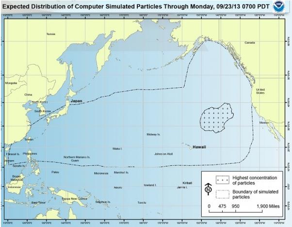
NOAA: There Is No Island Of Tsunami Debris Floating Toward The U.S. Nature World News (and NOAA) set us straight: "...
The media reports, some of which stated there was a Texas-sized island of tsunami debris
floating toward the US, developed from a NOAA report last week that
updated the latest tsunami debris information. The confusion about the
floating island of debris came from the NOAA map above, which predicts
the position of the tsunami debris based on simulations of how ocean
currents and wind likely dispersed it. The crosshatched area near Hawaii
represents the region with the highest concentration of tsunami debris,
not a cohesive "island" of debris. "At this point, nearly three years
after the earthquake and tsunami struck Japan, whatever debris remains
floating is very spread out..."
Map credit above: "
After
publishing a map detailing the theoretical position in the Pacific
Ocean of debris from the March 2011 tsunami that hit Japan, the National
Oceanic and Atmospheric Administration had to issue a clarifying
statement: “There is no solid mass of debris from Japan heading to the
United States.” (Photo : NOAA / Marine Debris Program).
NOAA View Data Imagery Portal (beta). Here's a
new tool for visualizing data, worldwide. Thanks to Capital Weather Gang for bringing this to my attention: "
NOAA
View provides access to maps of NOAA data from a variety of satellite,
model, and other analysis sources. NOAA View is intended as an education
and outreach tool, and is not an official source of NOAA data for
decision support or scientific purposes."
An Ex-Cop's Guide To Not Getting Arrested. I paid extra attention to this tale from
The Atlantic Cities; here's an excerpt: "...
Which
would make the question for you and me, how can we stay out of jail?
Carson's book does a pretty good job of explaining—in frank language—how
to beat a system that's increasingly predatory. Carson has four golden
rules, the first of which is, "If police can't see you, they can't
arrest you." The simplest application of this concept is that if you
plan on doing something illegal, you should do it in the privacy of your
home. Yes, you can be arrested while at home, but you can't be profiled
sitting in your living room, and profiling is what you're trying to
avoid..."
More Former NFL Stars Have Head Troubles. Here's an excerpt of a story at
kottke.org: "
Hall of Famer Tony Dorsett is among a growing group of former NFL players who have been diagnosed
with diseases caused by years of head trauma and other injuries. The
former Cowboys running back, now 59, said that when he took his Oct. 21
flight from Dallas to Los Angeles for testing, he repeatedly struggled
to remember why he was aboard the plane and where he was going. Such
episodes, he said, are commonplace when he travels. Dorsett said he also
gets lost when he drives his two youngest daughters, ages 15 and 10, to
their soccer and volleyball games..." (Image above: Google).
It's Official: Video Games Make Your Brain Bigger. Well that's a relief. Here's a clip from a story at
Quartz: "
Those
addictive videogames that keep players glued to the screen may actually
do the brain some good—or one of them does, anyway. A new study from the journal Molecular Psychiatry digs
into the effect of videogame play on the volume of the brain’s gray
matter—the tissue responsible for muscle control, memory, language and
sensory perception. Researchers
from Berlin’s Max Planck Institute for Human Development and St.
Hedwig-Hospital recruited adult subjects to play Mario 64 on Nintendo’s
portable DS system for thirty minutes per day for two months. At the end
of that time, the gaming subjects showed “significant gray matter
increase” in both the bilateral hippocampus and portions of the right prefrontal cortex..."
Playing Loud Pop Music Boosts Output Of Solar Panels By 40% How can possibly this be true? It turns out there may be something to this, after all. Here's an excerpt from
Click Green: "
Playing
loud pop and rock music improves the performance of solar cells,
according to new research from scientists at Queen Mary University of
London and Imperial College London. The high frequencies and pitch found
in pop and rock music cause vibrations that enhanced energy generation
in solar cells containing a cluster of 'nanorods', leading to a 40 per
cent increase in efficiency of the solar cells. The study has
implications for improving energy generation from sunlight, particularly
for the development of new, lower cost, printed solar cells..."
Climate Stories...
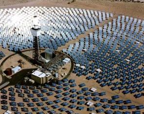
Global Warming: How To Kick The Fossil Fuel Habit, Part 1. The San Diego Free Press has the article; here's an excerpt: "
This article is based on an excellent book by Tom Rand: “Kick the Fossil Fuel Habit -
10 Clean Technologies to Save Our World.” It contains great information
at a reading level that even an elementary school child can comprehend.
And there are many superb pictures too. It is a wonderful resource in
the numerous technologies that are in the process of ridding the world
of fossil fuels – some of them hardly known to the literate public. At
least I wasn’t aware of them, and I consider myself somewhat
knowledgeable about global warming and what we can do about it. He
identifies ten different technologies. We will devote an article to each
of them. Part 1 will deal with solar..."
Photo credit above: Brightsource.
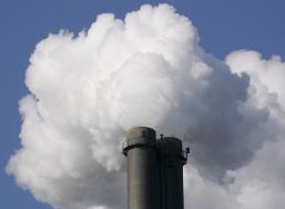
Greenhouse Gas Emissions Reached New High In 2012, World Meteorological Organization Says. CO2 emissions actually came down in the USA, but increased significantly in China and India. Here's an excerpt from Reuters and
Huffington Post: "
Atmospheric
volumes of greenhouse gases blamed for climate change hit a new record
in 2012, the World Meteorological Organisation (WMO) said on Wednesday.
"For all these major greenhouse gases the concentrations are reaching
once again record levels," WMO Secretary-General Michel Jarraud told a
news conference in Geneva at which he presented the U.N. climate
agency's annual Greenhouse Gas Bulletin. Jarraud said the accelerating
trend was driving climate change, making it harder to keep global
warming to within 2 degrees Celsius, a target agreed at a Copenhagen
summit in 2009..."
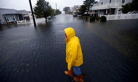
New York, London and Mumbai: Major Cities Face Risk From Sea Level Rises.
Too alarmist? We'll see, but here's the thing: this isn't about climate
models projecting out 50 years into the future. Sea level rise is a
documented reality. Since 1750 the water in New York Harbor has risen
about 15". The only question is how much higher, and how quickly. Here's
a clip from
The Guardian: "...
Strauss'
analysis only looks at the likelihood coastal cities will be under
water. Strauss forecasts the impact of rising seas without storms. He
doesn't forecast the likelihood that calamitous weather events like
Hurricane Sandy will cause far greater damage when the oceans have risen
closer to the level of the cities, overwhelming roads, sewers,
underground trains, and water systems. We can now imagine a day when
storms do not merely damage coastal cities but destroy them. He contends
that by 2100, more than 25% of Boston, Miami, New Orleans, and Atlantic
City could be under water. The same forecast (23 ft or 7m by 2100) can
be plugged into a global map of elevations and sea levels here.
Such a calculation is even more alarming. Most of the globe's economic
activity is funneled through cities that will be fighting to stay above
water. Imagine a world without Shanghai, Mumbai and Boston, a world in
which London and New York are risky settings for markets..."
Photo credit above: "
Ben
Strauss, Climate Central predicts that by 2100, more than 25% of
Boston, Miami, New Orleans, and Atlantic City could be under water." Photograph: Alex Brandon/AP.
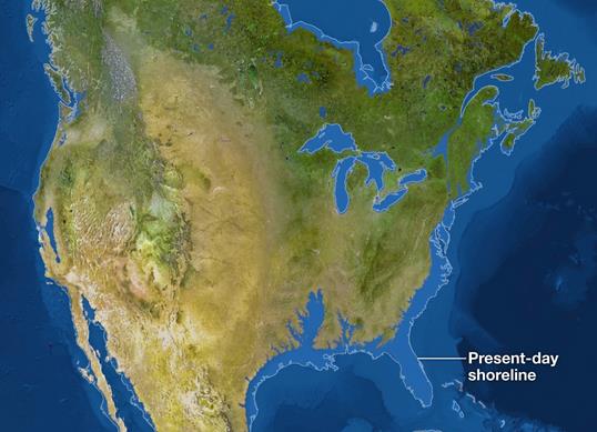
If All The Ice Melted.
Not likely to happen anytime soon, but you will see increasing pressure
along the world's coastlines in the years to come. Here's an excerpt
from an eye-opening interactive map from
National Geographic: "
The
maps here show the world as it is now, with only one difference: All
the ice on land has melted and drained into the sea, raising it 216 feet
and creating new shorelines for our continents and inland seas. There
are more than five million cubic miles of ice on Earth, and some
scientists say it would take more than 5,000 years to melt it all. If we
continue adding carbon to the atmosphere, we’ll very likely create an
ice-free planet, with an average temperature of perhaps 80 degrees
Fahrenheit instead of the current 58."
Interactive map credit
above: Jason Treat, Matthew Twombly, Web Barr, Maggie Smith, NGM staff.
Art: Kees Veenenbos. Sources: Pilippe Huybrechts, Vrije Unversiteit
Brussel, Richard S. Williams, Jr. Woods Hole Research Center, James C.
Zachos, Universoty of California, Santa Cruz, USGS, NOAA, ETOP01
Bedrock, 1 arc-minute global relief model copyright September 2013
National Geographic Society.
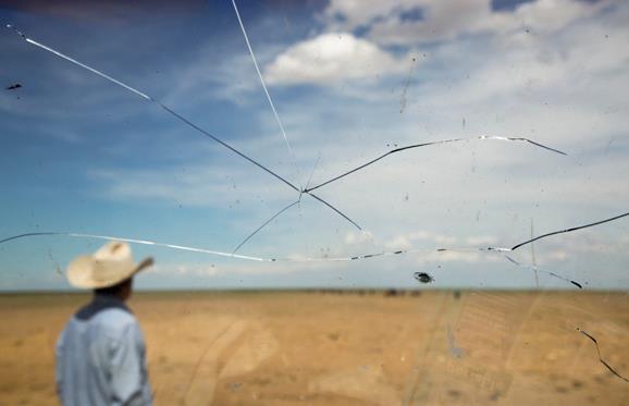
Why Even California Can't Stop Catastrophic Climate Change.
Quartz has the story - here's the introduction: "
For climate change optimists, California is indeed the golden state when it comes to aggressive policies designed to avoid catastrophic climate change. But as a new report makes depressingly clear,
even Ecotopia will fall far short of hitting a target of reducing
greenhouse gas emissions 80% by 2050 without the invention of new
technologies and imposition of more draconian green mandates. That’s
the number scientists believe must be met to keep climate change in
check. And if California can’t meet such a mandate, what nation can,
given the inability of governments to even to agree to take the most
tentative steps to reduce greenhouse gas emissions?..."
Photo credit above: "If even the Golden State can't pull off needed carbon cutting, expect more scenes like this." AP Photo/Mark Schiefelbein.
Can Attacking Scientists Be A Political Liability? Michael Halpern has the article (and possible implications of the Virginia governor's race) at
The Union of Concerned Scientists; here's the intro: "
Politicians attack scientists to score points with voters and their backers, whether it’s members of Congress attacking individual government grantees or belittling scientists whose research undermines their legislative priorities. It got so bad that UCS put out a guide for scientists
who find their work under an unusual amount of scrutiny (still a good
idea to take a look before you’re in that situation). But yesterday’s
election in Virginia may showcase how these sorts of attacks can
backfire, making a candidate look extreme and out of touch. For those
who haven’t followed the case, a recap: former University of Virginia
scientist Michael Mann is responsible for pioneering climate change
research that has since been reaffirmed by scores of researchers and
scientific bodies. Virginia Attorney General Ken Cuccinelli thought he
knew better. He made headlines around the world by issuing subpoenas to
UVa under the Virginia Fraud Against Taxpayers Act for Mann’s personal
emails and other documents (The scientist subsequently wrote a book about being raked over the coals by Cuccinelli and other politicians)..."
Virginia Governor's Race Shows Global Warming Science Denial Is A Losing Political Stance. Here's an excerpt from a
Guardian article posted by St. Thomas professor and climate scientist John Abraham: "...
Ken
Cuccinelli has a history of not only discounting scientists but
spending taxpayers' money to actively attack them. In 2010, he began a
witch hunt and accused climate scientist Dr. Michael Mann of fraud. In
the end, Cuccinelli's crusade wasted hundreds of thousands of
hard-earned taxpayer dollars – waste that Virginia voters did not
forget. As Dr. Mann himself, who campaigned for Terry McAuliffe, says,
"As discussed in some detail in my recent book The Hockey Stick and the Climate Wars,
Ken Cuccinelli, as a newly minted Attorney General of Virginia, back in
early 2010, engaged in what The Washington Post called a "witch hunt"
against me and the University of Virginia. He sought to abuse his
authority as attorney general by demanding all of my personal emails
from the six years I was a faculty member at the University of Virginia..."
Photo credit above: "
Terry McAuliffe made climate realism a big part of his campaign, and won yesterday's election to become Virginia's new governor." Photograph: Reuters.
Climate Change Puts 5 Million Israelis At Risk Of Severe Flooding Events. Here's a clip from a story at
The Jerusalem Post: "
Rising
temperatures and climbing sea levels due to climate change could be
putting more than five million Israelis at severe risk, a special
Environmental Protection Ministry report has indicated. The rise of the
Mediterranean Sea’s levels as well as the flooding of rivers could
gravely impact five million Israelis as water barrels into their
communities, the study warned. In addition to the flooding dangers, the
conditions could also result in outbreaks of transmissible diseases from
pests such as mosquitoes, the report explained. Escalating temperatures
combined with population growth will also undoubtedly lead to an
increased demand for water from decreasing aquifer supplies, it said..."
Photo credit above: "
A storm touches down on water off Atlit coast." Photo: Baz Ratner / Reuters
No, We Are NOT In A Climate "Pause".
Slate has the video and article; here's an excerpt: "...
One argument Hank brings up (at the 1:44 mark),
and one I’ve hammered on a few times as well, is this idea that we’re
in some sort of global warming pause. This is a claim that gets some
traction, because when you look at land surface temperatures over the
past few years, they haven’t gone up as quickly as they have in the
past. However, using this measurement to claim that global warming has
stopped, or even just paused, is wrong. The good folks at NASA Goddard
recently posted a video interview with climate scientist Josh Willis to put this claim to rest..."
Is It Too Late To Prepare For Climate Change? Here's an excerpt from an Elizabeth Kolbert article at
The New Yorker: "...
Promoting
“preparedness” is doubtless a good idea. As the executive order notes,
climate impacts—which include, but are not limited to, heat waves,
heavier downpours, and an increase in the number and intensity of
wildfires—are “already affecting communities, natural resources,
ecosystems, economies, and public health across the Nation.” However,
one of the dangers of this enterprise is that it tends to presuppose, in
a Boy Scout-ish sort of way, that “preparedness” is possible. As we
merrily roll along, radically altering the planet, we are, as the leaked
I.P.C.C. report makes clear, increasingly in danger of committing
ourselves to outcomes that will simply overwhelm societies’ ability to
adapt..."
