Cold and Quiet
"Too
cold to snow?" Not exactly, but when temperatures are in the teens it
often means the storm track, the main superhighway for heavy rain, ice
and snow, has been pushed well south of Minnesota.
A
well-advertised nor'easter will spread heavy rain and snow right up the
east coast today and Wednesday, complicating travel plans. I expect 2-3
inch rains east of I-95, with local flooding. Well inland over the
Appalachians some 1-2 foot snows are possible.
1 in 3
Thanksgivings have at least an inch of snow on the ground here in the
Twin Cities, but this will not be one of those years. Lake effect snows
kick in downwind of the Great Lakes but I expect a brown Thanksgiving.
Dry weather spills over into next weekend with slowly moderating
temperatures; low 30s returning by the weekend.
Big storms will
continue to detour well south of Minnesota into early December, but at
some point steering winds will buckle, and we'll see just the right
mixture of cold air and moisture for snow.
Keep an eye on
mid-December. Last year over 10 inches fell on December 9. Over 17
inches fell on December 10-11, 2010. Will history repeat itself in 2013?
I'm still betting on a very white Christmas.
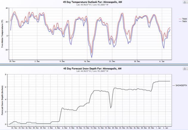
45 Day Wish-Cast.
No, this isn't a forecast, more like a horoscope, but I thought
snow-lovers would find this vaguely amusing. NOAA's CFS (Climate
Forecast System) shows a couple inches of snow around December 4, snow
on the ground increasing to 6" by the second and third week of December,
implying a (very) white Christmas. Don't bet the farm on a 45 day
"trend", but let's see how this works out.
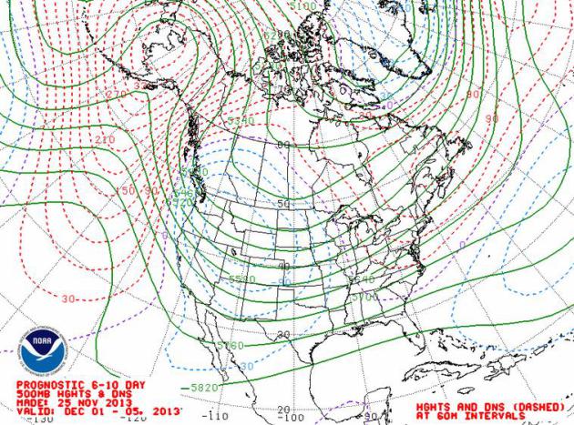
Stormier Pattern For Central USA?
Just about the time I was ready to totally dismiss the 45 day trend, I
got a look at 500 mb winds averaged between December 1 and 5, showing a
developing trough of low pressure over the Rockies and Plains, a "storm
incubator". With enough cold air in place and moisture bubbling out of
the Gulf of Mexico, the planets might just align for a better chance of
accumulating snow within 2 weeks.
Major Storm Brewing For The Busiest Travel Day Of The Year.
Great timing huh? An estimated 80-100 million Americans will feel the
effects of this storm, the same system that spanked the Deep South with
snow, ice and rain, now spreading a shield of heavy rain up the East
Coast. Today's
Climate Matters is focused on what is top-of-mind: will I be able to reach my Thanksgiving destination? "
WeatherNationTV
Chief Meteorologist Paul Douglas shows the possibility of a major storm
to affect the busiest travel day of the year. And just what has
Thanksgiving had in store for major cities across the US?"
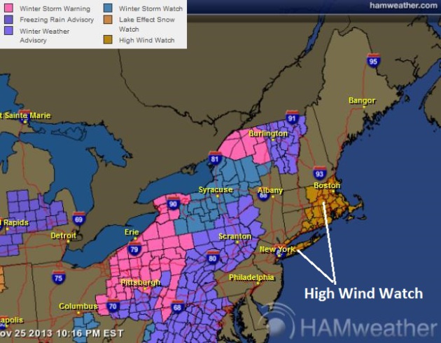
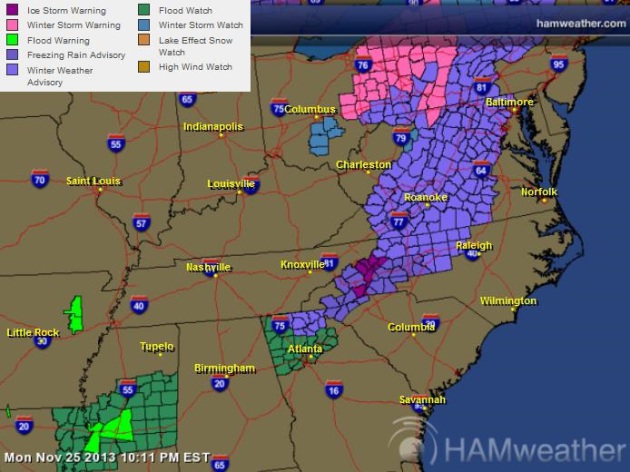
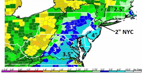
Northeast Warnings.
NOAA has issued a High Wind Watch from metro New York City and Long
Island to Hartford and Boston, for winds gusting in excess of 40 mph at
times. Winter Storm Warnings include Rochester, Buffalo and Pittsburgh,
where a healthy coating of white is likely by Wednesday night. A Winter
Storm Watch is posted for the western suburbs of D.C. and Baltimore for a
few inches of slush. No significant snow is expected east of I-95. For
the latest warnings and advisories from Ham Weather
click here.
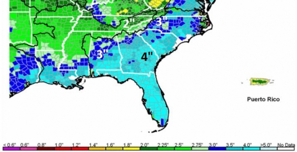
Mid Atlantic Warnings.
As of late last night Ice Storm Warnings were posted near Asheville,
North Carolina, a Winter Storm Watch for the hills of northern Georgia,
and from the western Carolinas into much of the Virginias and western
Maryland. Latest warnings from NOAA and Ham Weather
here.
East Coast Storm Details. Here's an excerpt of an earlier
Alerts Broadcaster briefing:
*
Much-advertised storm still on track to soak the East Coast today into
Wednesday; significant risk of flash flooding and urban flooding.
*
Heavy rain event along and east of I-95; 1-4" snowfall between I-95 and
I-81 - potential for a very heavy wet snow over higher elevations from
northern Georgia and the Carolinas into the Virginias, central and
western Pennsylvania, upstate New York and interior New England.
* Heaviest rain and snow pushes out to sea in time for Thanksgiving.
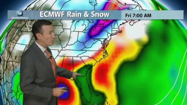
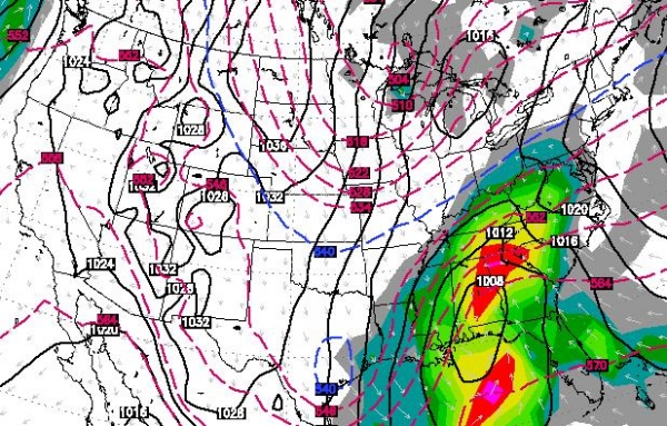
Timing The Storm.
For the southeast today will be the wettest day, a shield of moderate
to heavy rain with embedded T-storms from Huntsville to Atlanta,
reaching Charlotte and Raleigh by afternoon. The greatest risk of
localized flash flooding will come this afternoon into Tuesday night,
especially in poor drainage areas and regions that often flood during
major storms. ECMWF (European) model map above valid midday tomorrow.
Map: WSI.
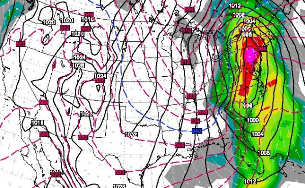
Wednesday Morning: Storm Peaks Mid Atlantic & Northeast.
The map above verifies at 6 AM Wednesday, what promises to be a
horrific travel and commuting day from Richmond and Washington D.C. to
New York and Boston. Expect wind-driven rain, heavy much of the morning
and midday, tapering late Wednesday as cold winds kick in on the
backside of this intense storm. Rain will end as a period of wet snow
from Roanoke and the western suburbs of Washington D.C. to Harrisburg,
Allentown and western New Jersey. ECMWF guidance: WSI.
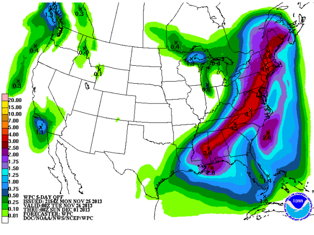
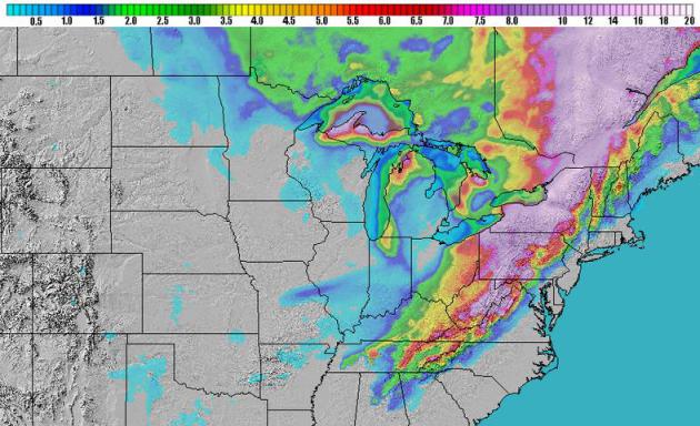
Soaking, Potentially Flooding Rains.
Models have been consistent in printing out excessive amounts of water
with this storm, fueled with moisture from the Gulf of Mexico and the
Atlantic. I still see a swath of 2-4" rains from Atlanta and Charlotte
to Washington D.C., Philadephia and New York City, most of that falling
late Tuesday into Wednesday morning. NOAA guidance (above) is even
hinting at some 5" amounts from the hills of northern Georgia to the
suburbs of New York City - capable of initiating street and small stream
flooding.
Flash Flood Thresholds.
The map above shows how much rain has to fall to initiate flash
flooding; some 3-4" for much of the southeast, but closer to 2-3" for
the Carolinas. This is why we're concerned about the risk of urban and
small stream flooding. Flash flood guidance courtesy of NOAA.
Lower Flash Flood Thresholds Northeast.
Because the ground is partially frozen much of the rain that falls will
run off into streets and streams late Tuesday into Wednesday,
increasing the potential for flash flooding, especially D.C. and
Baltimore into New York City. In New York the threshold for flash
flooding is closer to 2"; models print out close to 4" of rain for the
Big Apple.
Heavy Snow Potential.
A light (nuisance) accumulation of slush is possible generally west of
I-95, most of that coming at the tail-end of the storm Wednesday into
Wednesday night. West of I-81 amounts will be more significant, probably
"plowable". Some 12-20" amounts are predicted from Virginia's
Shenandoah into central and western Pennsylvania and New York. NAM
snowfall totals above: NOAA and Ham Weather.
Summary:
The timing isn't great, coming during the most-traveled week of the
year for for the USA. The same storm system that has been tormenting the
southern Rockies and southern Plains with snow and ice will track up
the east coast Tuesday and Wednesday, providing a 1-2 punch of heavy
rain and mountain snows. The good news (which is hard to find this
morning): right now I don't see any widespread severe storm outbreak or
enhanced risk of tornadoes in the warm sector of this storm - and beach
erosion from the Outer Banks to Long Island and Cape Cod should be minor
to moderate. Tuesday looks like the worst day for the Southeast;
Wednesday will be the peak-trouble day for the Mid Atlantic and New
England region with significant impact on travel by air and land. Expect
delays and impacts to facilities, staff and customers.
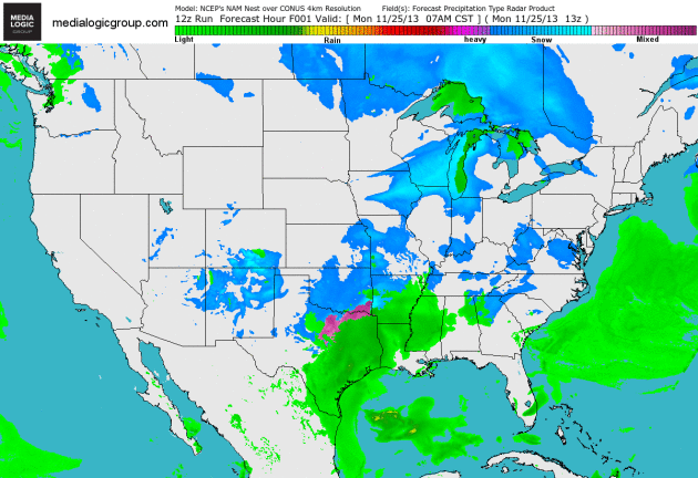
Future Radar.
NOAA's 4km NAM model shows precipitation starting out as a wintry mix,
then quickly changing to (heavy) rain for the eastern seaboard, with a
changeover back to snow (from west to east) across the Appalachians
Wednesday as colder air pushes in on the backside of today's intense
coastal storm. The storm will push out to sea in time for Thanksgiving.
Animation: Ham Weather.
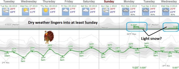
Chilly, But Quiet.
Dry weather persists into the weekend; great news for travel within 300
miles of MSP. Today will be the coldest day, highs flirting with 20F,
the wind making it feel like single digits. Temperatures moderate
slightly by the end of the week; the next chance of light snow coming
Monday, again Wednesday of next week. Graph: Weatherspark.
Ouch.
Long-range GFS model guidance shows a wintry swipe after December 5.
The models have been fairly consistent from run to run, which increases
our confidence level that this (arctic) front is real. We may go the
better part of 5 days with highs in single digits to low teens, nights
dipping below zero. Lovely.
Typhoon Haiyan: How A Catastrophe Unfolded.
Here is one of the more comprehensive, well-researched stories I've
read on why the recent tragedy in the Philippines was far worse than
even the most pessimistic outlook; an excerpt and video from
The Wall Street Journal: "...
Some
officials miscalculated the biggest threat that Typhoon Haiyan posed to
the city and its surroundings. They used a term for the storm that
wasn't widely understood. They grossly underestimated the havoc the
storm would wreak, stocking far too few supplies for a city to survive
on in an emergency. And they failed, despite vigorous efforts, to move
many of the most vulnerable people out of harm's way. For almost 24
hours, local and national officials in Tacloban had no way even to call
for help. They had simply failed to imagine a storm so large. That
failure of imagination, combined with residents' skepticism that the
storm would be worse than any of the other 20 or so that lashed the
scattered archipelago every year, had a deadly and devastating impact..."
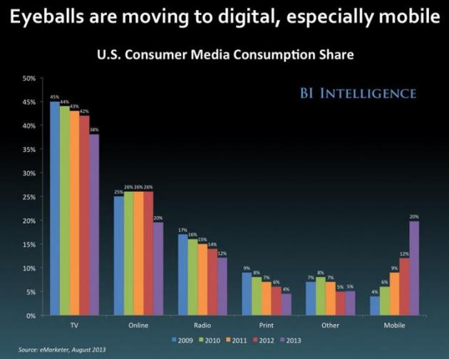
TV Is Dying, And Here Are The Stats The Prove It.
We're all hard-wired to want to watch narratives with interesting
storylines and compelling characters (that applies to sports as well).
But will we be watching "TV" or videos on our mobile devices, streaming
them to our monitors when we're home? I'm a little skeptical of pundits
predicting the end (of anything). Newspapers were supposed to die 10-15
years ago, and yet most have found ways to innovate and reinvent. The
same thing may happen with traditional TV, although cable providers have
their work cut out for them, as outlined in this comprehensive story at
Business Insider. Here's an excerpt: "...
We're
at the beginning of a major historical shift from watching TV to
watching video — including TV shows and movies — on the internet or on
mobile devices. This is going to hurt cable TV providers. Nearly 5
million cable TV subscribers have gone elsewhere in the last five years.
The number of cable TV-only subscribers remaining could sink below 40
million later this year, according to this data from ISI Group, an
equity research firm (at right)...." (Graphic: Business Insider).
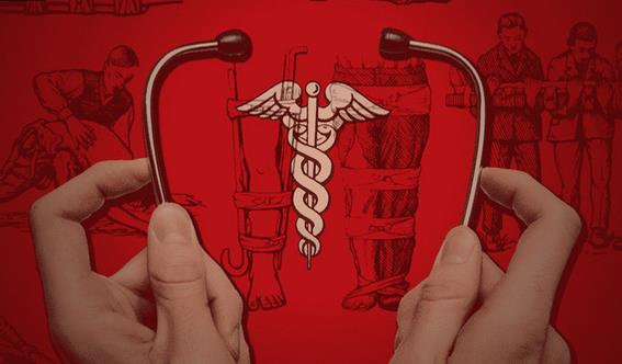
8 Basic Life-Saving Skills Everyone Should Know. Here's a clip from a must-read article at
Lifehacker: "
We've featured a ton of survival and MacGyver tips
over the years that could help you out of a fix, but what if you're
next to someone else who's having an emergency? Don't just stand there
as the person chokes or faints! Know what to do in these life-or-death
situations...These things in mind, you don't need to be an Emergency
Medical Technician or other health pro to possibly save someone's life
one day. Here are a few things to know...."
Canadians Rescue Shark Choking On Moose.
This may be my favorite headline of the week, and it could only happen
in Canada (or maybe a remote stretch of northern Alaska). Here's a clip
from
Outside Magazine: "
Two men pulled off what was perhaps the most Canadian animal rescue mission of all time this week when they saved a large Greenland shark
from choking to death on a moose. Derrick Chaulk was driving along the
coast near Norris Arm North in Newfoundland when he spotted what he
believed to be a beached whale. The beached whale turned out to be a
shark with a big hunk of moose hide hanging out of its mouth..."
Two Concussions Turned This Student Athlete Into A Musican Prodigy.
So you're telling me...I have a shot at greatness! Just when you think
you've heard everything there is to hear, along comes this story and
video from
Time Magazine - here's a clip: "...
But
doctors say that Lachlan’s head injuries, which barred him from playing
contact sports again, rewired his brain. So while he had to ditch
football and lacrosse, Lachlan found out that he could play 10-13
instruments by ear with ease. Including two types of bagpipes. Because
just one is for musical hacks.."
How To Cook Your Holiday Turkey In The Dishwasher. Because you're too lazy or inept to use an oven? O.K. My second-favorite headline of the week, courtesy of the
L.A. Times: "
If you can't seem to keep your Thanksgiving
turkey moist in the oven, you may want to try your dishwasher. Yes,
people have been using the kitchen washing machine to cook proteins and
fish since the 1970s, but famed chef David Burke insists you can also
use it to cook the star of your Thanksgiving meal. But before you start
shoving your entire turkey in the dishwasher, Burke's recipe calls for
two boneless turkey breasts, not the entire bird. The meat and herbs are
packed tightly in plastic wrap then sealed in Tupperware containers
before hitting the top shelf of the dishwasher for three cycles or about
3 hours and 25 minutes..."
Photo credit above: "
Charlotte
H. Pownell, consumer relations director at an appliance company, shows
off a whole salmon and vegetables, seasoned and cooked in a
triple-thickness of foil in a dishwasher in 1970."
(Los Angeles Times).
Climate Stories...
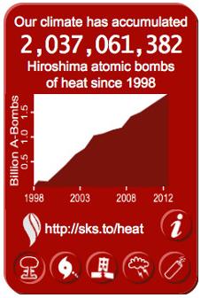
New Widget Counts Global Warming - Happening At 4 Hiroshima Atomic Bombs Per Second. Here's a clip from a story at
The Guardian: "
Global
warming is accumulating in the Earth's climate system at a rate
equivalent to about 4 Hiroshima atomic bomb detonations, 2 Hurricane
Sandys, or 4 magnitude 6.0 earthquakes per second. The amount of energy
building up on Earth due to human-caused global warming can be difficult
to picture. 250 trillion Joules per second sounds like a lot, but what
does that mean in terms people can more easily visualize? This widget, created by Bob Lacatena at Skeptical Science, tries to do just that. The widget can be installed on most blogs
and is customizable, allowing users to choose the color, size, button
style, and starting year. For example, since 1998, the Earth's climate
has accumulated over 2 billion Hiroshima atomic bombs worth of energy..."
Warsaw Climate Change Talks End On A Blurry Note.
Let's kick the can down the road a few more years. Here's a summary of
what happened (and did not happen) at the latest international climate
change talks in Warsaw, courtesy of
Politico: "
After
tense eleventh-hour negotiations, delegates at international climate
talks in Warsaw, Poland, could agree to only a broad set of terms aimed
at setting world nations on a path toward a 2015 global warming accord
while avoiding the troublesome specifics for now. The U.S. and other
countries agreed Saturday that, by early 2015, they will put forward
their individual plans for lowering emissions, a move that gives nations
less than a year to review the plans before key December 2015 talks in
Paris. But negotiators in Warsaw failed to agree on key details, such as
what the plans should include and how they should be evaluated..."
Photo credit: "
Delegates
attend the closing session of the 19th conference of the United Nations
Framework Convention on Climate Change in Warsaw, Poland, on Friday,
Nov. 22, 2013. The talks intended to lay foundations for the new climate
deal in 2015 were scheduled to end Friday, but it became apparent
during the day that the fine tuning would go well into Saturday." (AP Photo/Czarek Sokolowski).
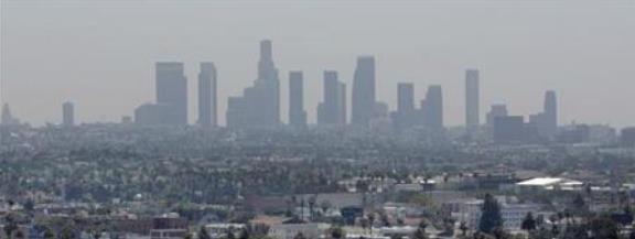
Analysis: U.S. Air Pollution Authority Faces Supreme Court Tests. Here's an excerpt from a good summary of what's at stake from
Reuters: "
The
U.S. government's authority to regulate air pollution nationwide, often
against the wishes of Republican-leaning states, could face new curbs
when the Supreme Court takes on two high-stakes cases in coming months.
The cases focus on the broad-ranging power wielded by the Environmental
Protection Agency (EPA) under the landmark Clean Air Act, first enacted
in 1970. The law was envisioned as a
cooperative effort between the federal government and states in which
the EPA sets standards but states have to set plans to comply.
That flexibility has allowed states which favor looser regulations,
like Texas and Kansas, to resist - with the support of industry groups
like the U.S. Chamber of Commerce and the National Association of
Manufacturers - when the agency wants to impose more stringent standards..."
Photo credit above: "The
skyline of downtown Los Angeles through a layer of smog is seen in the
distance from a rooftop in Hollywood, California, May 31, 2006." Credit: Reuters/Fred Prouser/Files.
Tired Of Negativity? Here's a clip from an Op-Ed at
Huffington Post that resonated: "...
Large-scale
solutions to large-scale problems: the key to optimism, hope and
resilience. That's what I'm going to carry in my heart over the next
year as I write to you about air pollution and our changing climate.
Optimism comes from health leaders, creative thinkers and innovative
leaders in the business, technology and engineering community. And from
political leaders willing to speak the truth in dark times. Optimism
comes from our own thoughtful friends and neighbors who are mindful of
resources, living by some pretty old-fashioned values: stewardship;
respect. Optimism comes from those whose moral compass is pointing true
north -- where a love of the world resides."