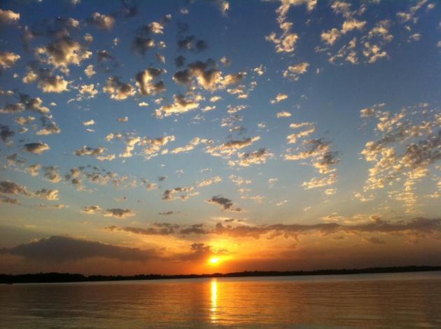
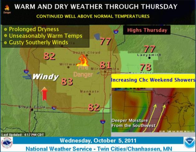
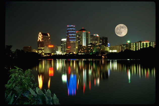
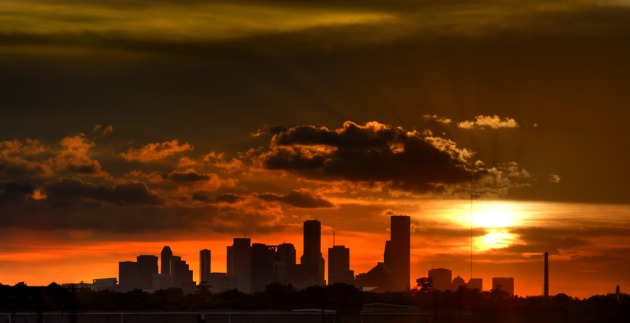
88 F. high in the Twin Cities Wednesday, a new record for October 5. Old record: 87 in
1879
63 F. average high for October 5.
 Number of Days Above 80 In October at MSP:
4 days
Number of Days Above 80 In October at MSP:
4 days: 2010, *2011
3 days: 2007, 2006, 2003
2 days: 2005
1 day: 2001, 2000
10 days:
1953 (all-time record, according to Pete Boulay at the State Climate Office).
* a total of 17 days above 80 in October since 2000, according to friend and meteorologist Dan Lilledahl, a Minnesota transplant now living in Atlanta. Thanks Dan!
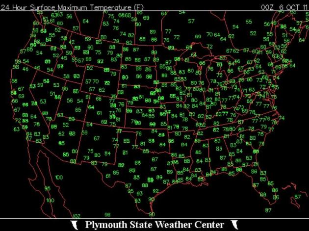 Upside Down Weather Map
. Let me get this straight: on Wednesday it was hotter in the Twin Cities of Minnesota (88) than Phoenix (85), Dallas (87), even Miami (86)?? Record warmth continues over the nation's midsection, while New England experiences cool 50s and 60s, and much of the west experiences the first wintry cold front (and heavy snow) of the season. Map courtesy of the
Plymouth State Weather Center.
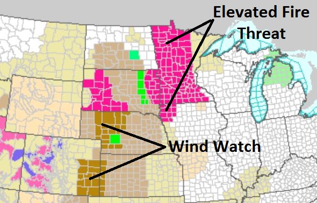
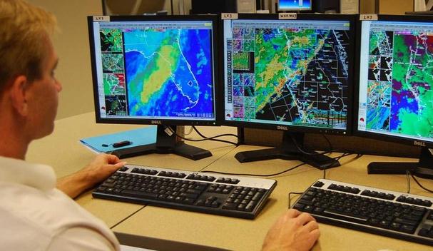
Elevated Fire Threat Lingers Into Friday. Here's the latest from the local NWS:
High Brushfire Potential. With gusty winds, bright sun and tinder-dry relative humidity levels - conditions are ripe for fires, wildfires capable of spreading rapidly once underway. The only good news:
dew points and humidity levels begin to rise later today into Friday - more water in the air lessening the risk (slightly). The bad news: Friday winds may gust to 30, even 35 mph from the south. More from the local NWS
here.
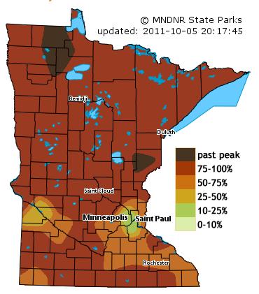
Peaking Fall Color. The latest
DNR fall color report is in, and it shows that 75-100% of Minnesota's forestland has ripened - we are very close to peak color statewide. Colors should peak from the Twin Cities southeastward down Highway 61 to Winona from October 7-15.
132 days/row above 90 at
Austin, Texas this summer. The previous record was 104 days in a row. Whew...
* A cold weather front took aim at Northern California Tuesday, packing a potent punch with as much as 10 inches of snow for the Sierra peaks, the
earliest return of winter conditions to Tahoe since 1969, according to weather forecasters. According to the Central Sierra Snow Lab, the flurries predicted with this storm will make the shortest duration between snow storms since 1969. The lab – located in Norden – got its last measurable snow on July 1 – 96 days ago. - KTVU-TV.
*
Charleston and
Columbia, SC (51F and 40F),
Jacksonville and
Gainesville, FL(46F and 47F), and parts of
Arkansas all reported record lows in the past two days.
* On the other hand, parts of the northern US are experiencing record highs.
Grand Forks, ND reported a record high of 83F,
International Falls (82F),
Marquette,MI (76),
Chyenne, WY(88F),
Dickinson, ND (95F) and many others reported record highs in the last 48 hours.
* 1.15" rain in
Los Angeles Wednesday, breaking the old 24 hour rainfall record for October 5 (.61" in 1916).
"...
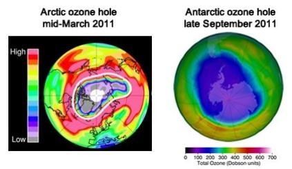
According to research published in the journal Nature this week, the largest ozone “hole” on record above the Arctic opened up last winter, exposing residents of the Far North to high doses of harmful ultraviolet (UV) radiation, which can cause skin cancer and cataracts. The area of severe ozone loss extended southward from the Arctic to cover populated areas in northern Russia, Greenland and Norway." - story below on record ozone depletion over the northern hemisphere last winter in the Washington Post's Capital Weather Gang.
 5-Day Projected Rainfall.
 Significant rain is forecast for the central and southern Plains (including the Texas Panhandle!) Note the rainy bullseye over Florida - long range weather models trying to spin up some sort of tropical wave or depression. I would not be surprised to see a tropical storm form in the Gulf of Mexico - or possibly off the east coast of Florida by early next week.
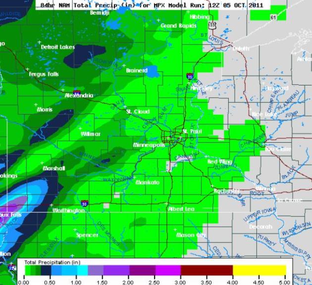 Meager Rainfall Amounts.
 The latest NAM/WRF model prints out some 1-1.5" rainfall amounts for far southwestern Minnesota, south/west of Marshall, but most of the state is forecast to pick up less than .10" through the weekend. The drought is going to get worse before conditions improve - hopefully before the flakes begin to fly.
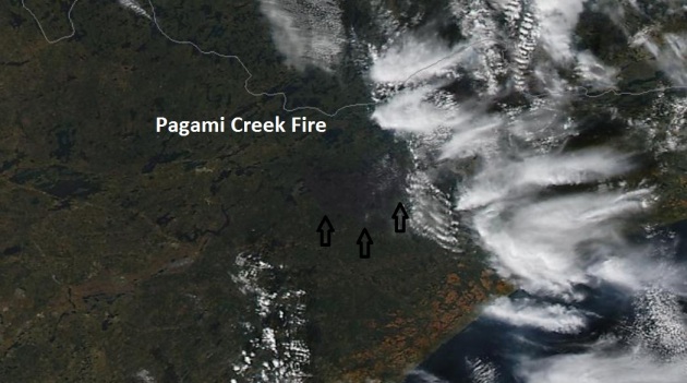
Pagami Creek Blaze From Space. NASA's high-resolution "
MODIS" satellite image taken midday yesterday shows the 93,000 acre BWCA fire, now 71% contained. From 200+ miles overhead it's possible to make out the charred regions of the Boundary Waters.
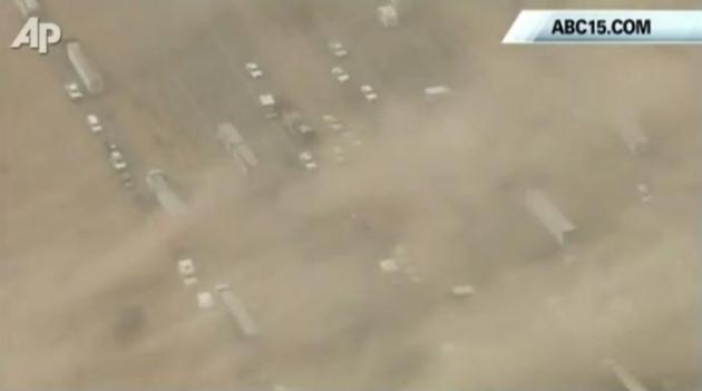
Massive Dust Storms Hit Arizona. At least three separate multi-car pile-ups were reported on Interstate 10 in Arizona Tuesday, as 30-50 mph winds whipped up billowing clouds of dust that dropped visiblities to zero at times. Several fatalities were blamed on the chain-reaction collisions that resulted from this dusty "white-out", scores of serious injuries - hundreds of vehicles may have been involved. Check out the
YouTube video here.
September Recap. Thanks to Greg Spoden from the Minnesota State Climate Office. Click
here for the complete report. A few highlights:
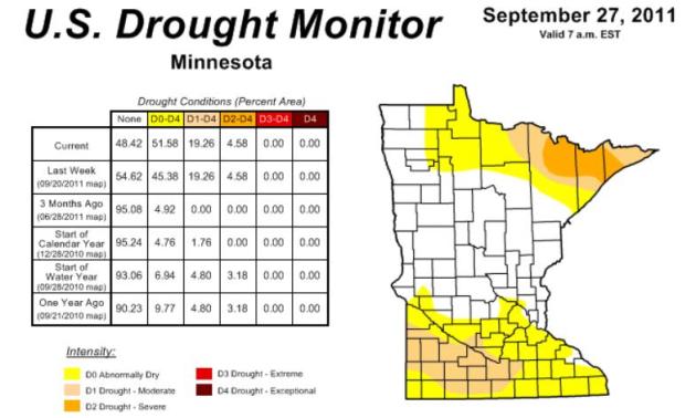
- September 2011 was an exceptionally dry month across Minnesota. This marked the second consecutive month of widespread rainfall shortfalls. In numerous locales, it was the driest September in the modern record.
- Significant rainfall shortfalls have been reported across Minnesota over the past two and one-half months. When compared with the same ten-week period in the historical database, the 2011 precipitation totals rank among the lowest on record.
- Topsoil moisture across 54 percent of Minnesota's landscape is considered to be "Short" or "Very Short".
- The U. S. Drought Monitor, released on September 29 depicts many counties in both southern and northern Minnesota as experiencing drought conditions. Portions of St. Louis, Lake, and Cook counties are said to be undergoing "Severe Drought" or "Moderate Drought". A large portion of south central and southwest Minnesota is placed the "Moderate Drought" category.
Hurricane Season Isn't Over Until It's Over. We're more than halfway through the hurricane season, but it's a little early for coastal residents to let their guard down, at least through the end of October. I suspect we'll have at least one more close encounter with a tropical storm or hurricane, maybe two.
Tampa Bay Online has the story:
"The hurricane season may be more than half over, but that doesn't mean we should become complacent. "All it takes is one, said Dan Noah, a meteorologist at the National Weather Service's Ruskin station. Noah advises people to ignore the seasonal, long-range forecasts and focus on being prepared for a single big storm each year. "The last major hurricane to hit the Tampa Bay area was in 1921," he said. "Statistically, we're long overdue. And if you haven't looked at the hurricane maps since 2009, you better do it now." Due to state-mandated changes in 2010, Noah said, residents and business owners might be in for a big surprise. After the state paid for planes equipped with special radar to fly along the coastline to get high-resolution data on elevations, the National Oceanic Atmospheric Administration used the information to develop more accurate simulations of hurricane storm surge. As a result, storm surge evacuation zone C became much larger. Some properties formerly in zone D are now in it. Noah said people should take these changes seriously. "Storm surge, which can last more than 12 hours, kills more people than any other hurricane impact," he said."
 Link Of The Day.
 This is pretty cool - a
web site that shows which part of the planet is in daylight or darkness. Kudos to opentopia.com.
 Steve Jobs: 1955-2011.
 The coverage of Steve Jobs' death last night was borderline bizarre - it almost seemed like a live, televised wake. There were comparisons to Thomas Edison, which seemed more than appropriate, considering Steve's 300 patents. Both my boys called me last night to check in and make sure I was OK; they knew how much I idolized this guy, what an inspiration he was to so many aspiring businesspeople. Jobs was (in my humble opinion) the definition of everything that is right with this country, what one genius can do when he surrounds himself with amazingly smart people and sells them on his vision.
I can't think of an individual who has done more to mold tastes and kickstart innovation in global consumer electronics than Steve Jobs. From computing to music to movies to the iPhone, which is so much more than a "phone" - it's a pocket-size GPS-enabled, photo/video global communicator - he knew what we wanted even before we did. Around the world, many people equated USA = Apple = Cool. He may have been our most important ambassador. Every entrepreneur looked up to him - he defined passion and fighting for what you truly believe in. Steve Jobs made it cool to dream. He turned Apple around when the company was weeks away from bankruptcy. He proved the skeptics wrong time and time again. Most important for kids of all ages....Steve Jobs made it OK to dream big dreams. He proved there is still magic in the world.
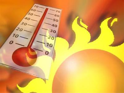
A Little Too Nice?
"Paul, you've been standing too close to the Doppler - how can the weather be too nice?" It's too dry out there, too sunny, too windy, relative humidity levels too low - resulting in an enhanced risk of wildfires. "Red Flag Warnings" are rare in the Twin Cities, much more likely in Denver, Dallas or southern California.
In the 1800s nothing struck fear in the heart of Prairie settlers more than fire. Tornadoes, floods, blizzards were bad enough, but wildfires elicited a sense of dread...and respect. Survivors used nearby lakes as a refuge of last resort; in some cases they would soak burlap bags and hide in the basements, praying the flames would pass over them.
We've come a long way in being able to track and fight fires, but the threat remains. The Forestry Service reports a 4X spike in western wildfires since 1970.
Climate Stories....
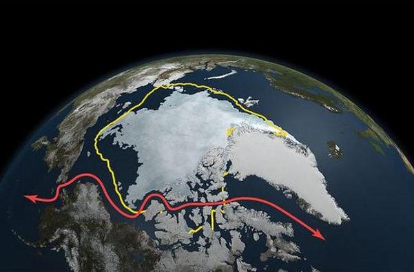
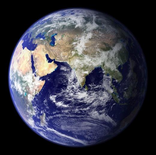
NASA: Climate Change Shrinks Arctic Sea Ice To Near-Record Level. Here's a story from the
WJLA-TV Weather Blog: "
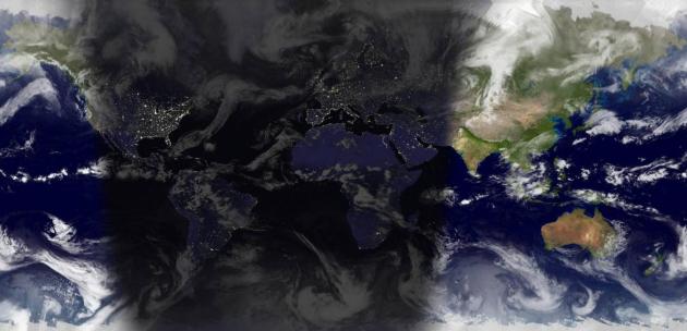
The sea ice capping the Arctic Ocean is melting away much faster and in more critical areas than initially predicted, and could dissolve entirely into tepid water earlier than 2100, a group of scientists said today. The sea ice, which typically reaches its lowest extent each September, was the second smallest in known history this past month, according to researchers from NASA and the National Snow and Ice Data Center at the University of Colorado in Boulder. You can see how far the white ice has receded in the above map. (Larger, and here's a great movie of the cap from March 7 to Sept. 9.) The yellow line represents the 30-year average September extent, and the red line is the Northwest Passage, a shipping route that is becoming increasingly viable thanks to ice loss. The teeny-tiny ice cap in 2007 still holds the record for lowest-ever extent, but that's no great comfort, because there were mitigating factors causing that incredible melt."
Photo credit above: "
Arctic sea ice from March 7 to Sept. 9, 2011, as measured by the Aqua satellite. The yellow line depicts the 30-year average extent of the ice; the red line is the Northwest Passage shipping lane. (NASA)"
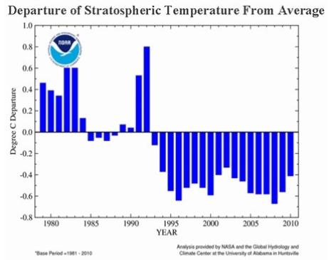
Record Breaking Ozone "Hole" And Global Warming. Here's an interesting post from The
Capital Weather Gang's Andrew Freedman: "
For years, polls have shown that many Americans have conflated two distinct atmospheric calamities – the destruction of the planet’s stratospheric ozone layer, and global warming. A 2010 poll by Yale University found that 21 percent of respondents believe the greenhouse effect refers to the ozone layer, rather than to gases in the atmosphere that trap heat, such as carbon dioxide. Now comes a study that helps describe the possible relationship between the two in a way that will either confuse even more people, or clarify things for anyone who devotes some time to fully digesting the new information. According to research published in the journal Nature this week, the largest ozone “hole” on record above the Arctic opened up last winter, exposing residents of the Far North to high doses of harmful ultraviolet (UV) radiation, which can cause skin cancer and cataracts. The area of severe ozone loss extended southward from the Arctic to cover populated areas in northern Russia, Greenland and Norway."
Cooling Stratosphere. It may be counterintuitive - but greenhouse gases trapping man-made warmth in the lower atmosphere may be resulting in consistently colder winter temperatures in the stratosphere, the upper atmosphere. A colder stratosphere makes the chemical reaction that destroys ozone more likely - ultimately increasing the amount of harmful radiation reaching the northern latitudes. Graphics above courtesy of NASA, NOAA and Capital Weather Gang.
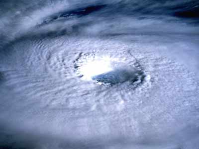
Is Global Warming Giving Typhoons Added Punch? Japan's
Yomiuri Shimbun has the details: "
The relationship between global warming and extraordinary weather phenomena such as unusually strong typhoons and torrential rain is becoming increasingly worrisome. Experts predict that global warming would actually help reduce the number of typhoons, as a smaller difference in temperature between the surface of the sea and the air above is believed to weaken the rising air currents that form a typhoon's storm center. However, global warming causes a large amount of water vapor to rise from the sea, increasing the size of typhoons as they develop. Taiichi Hayashi, associate professor at Kyoto University and an expert in meteorology, said, "Because global warming affects the climate of the whole planet, it's difficult to analyze how it has affected the occurrence of typhoons this year." Meanwhile, torrential rainfall has become more prevalent over the past few decades. The Meteorological Agency categorizes rainfall between 50 millimeters and 80 millimeters per hour as "extremely heavy" and rainfall above 80 millimeters as "intense." Torrential rain was recorded an average 193 times between 1991 and 2000 at 1,000 monitoring stations nationwide. This number increased to 218 between 2001 and 2010. This year, 130 instances of heavy rain have been recorded through August." (typhoon photo courtesy of
disasternewsnetwork.com).
 Hot To Be The New Normal As Species Struggle
. Here's a story from the
Sydney Morning Herald: "Soaring temperatures last century may have been hard work for many species across the planet but, by the end of this century, those temperatures, once considered extreme, will become the norm for many of the world's most delicate ecosystems. Research suggests that, over the coming decades, increased temperatures and rainfall will put increased stain on the survival of the Global 200 ecoregions, threatening both plant and animal life. The Global 200 is a set of ecoregions that the World Wildlife Fund (WWF) has classified as having exceptional biodiversity. They contain a high concentration of the earth's species.....Dr Beaumont's study looked at how much climate change is required for monthly temperature and rainfall patterns - which would have been considered "extreme" by 20th-century standards - to become the norm for each of the Global 200 ecoregions."
UN Climate Change Envoy Urges Action To Avert Floods, Drought, Hunger. Here's a story from the
Medill School of Northwestern University in Chicago: "
U.N. special envoy on climate change Dr. Gro Harlem Brundtland and her 22-person international commission started warning countries to avert global warming in 1987. Twenty-five years later, the former Norwegian prime minister said the ongoing lack of international cooperation to curb carbon emissions and invest in clean energy threatens us all. Already, drought, hunger and disease connected to rising temperatures jeopardize “our common future,” she told a large audience at the University of Illinois at Chicago. International investment in clean energy is crucial for putting people and the planet on track for a viable future, according to Brundtland, a world leader on global warming and human health. But sluggish national and global talks on climate change strategies means scenarios for severe consequences of fossil fuel-driven temperature rise etch a hazardous path for the world’s growing population."
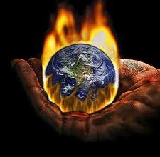
Global Warming: It's Not Political, And It's Not Complicated. Here's an interesting entry from
opednews.com: "
I fail to understand why global warming and its result, climate change, are seen to be a political or religious issue by so many on the far right. Global warming is a scientific issue, it's real, it's happening and it's dooming our grandchildren, if not our children, to live in a very different, much less hospitable world than the one we know. We can, to a degree, change this but not as long as we give any credence to the religious witch doctors and the political shamans on the fringe arguing from a position of ignorance. How our planet creates and regulates climate, as opposed to weather, is a tremendously complex process but how excessive emissions of greenhouse gases, the largest concentration of the gasses being carbon dioxide (CO2), causes the planet to warm isn't. It only requires that you understand a little about how the sun's energy reaches Earth, how green house gases interact with reflected infrared radiation and how our planet uses carbon sinks to control the amount of green house gasses in the atmosphere through a complicated feedback system."