Medtronic Twin Cities Marathon Weather
: Clear and comfortable with low humidity, a light south breeze at 10 mph.
8 am 10 am noon
49 58 67
*
Twin Cities In Motion poster credit
here.

PUBLIC INFORMATION STATEMENT
NATIONAL WEATHER SERVICE TWIN CITIES/CHANHASSEN MN
258 AM CDT SAT OCT 1 2011

...PUBLIC INFORMATION STATEMENT...

DRIEST SEPTEMBER ON RECORD SET AT MINNEAPOLIS/ST PAUL
INTERNATIONAL AIRPORT

A NEW RECORD LOW PRECIPITATION TOTAL FOR THE MONTH OF SEPTEMBER
WAS SET WITH JUST 0.36 INCHES OF PRECIPITATION RECORDED THIS
SEPTEMBER. THE PREVIOUS RECORD DRIEST SEPTEMBER OCCURRED IN 1940
WITH 0.41 INCHES RECORDED THAT SEPTEMBER.

...BELOW IS AN UPDATED LISTING OF THE FIVE DRIEST SEPTEMBERS RECORDED
AT MSP...

YEAR       PRECIPITATION TOTAL (INCHES)
---------------------------------------
2011                      0.36
1940                      0.41
1952                      0.42
2009                      0.46
1969                      0.49


...BELOW IS A LISTING OF OTHER LOCATIONS THAT ALSO SAW VERY LOW
PRECIPITATION TOTALS IN SEPTEMBER 2011...

LOCATION   PRECIPITATION TOTAL (INCHES)
---------------------------------------
REDWOOD FALLS             0.13
CHANHASSEN (NWS OFFICE)   0.26
FLYING CLOUD AIRPORT      0.28
MANKATO                   0.32
ST. PAUL                  0.47
CRYSTAL                   0.48
RED WING                  0.58
ST. CLOUD                 0.74
ALEXANDRIA                0.87
 MLB Forecast For Today:
Detroit Tigers at New York Yankees — Game 2
MLB Forecast For Today:
Detroit Tigers at New York Yankees — Game 2
3 PM Eastern — Yankee Stadium, Bronx, NY
First Pitch: 65° Cloudy, isolated shower; Wind SE 10 mph
7th Inning Stretch: 65° Cloudy, isolated shower; Wind S 10 mph
Final Out: 64° Cloudy, isolated shower; Wind SW 10 mph
Arizona Diamondbacks at Milwaukee Brewers — Game 2
5 PM Eastern (4 PM Central) — Miller Park, Milwaukee, WI
First Pitch: 64° Sunny; Wind NW 5-10 mph
7th Inning Stretch: 59° Sunny; Wind NW 5-10 mph
Final Out: 54° Clear; Wind NW 5-10 mph
St. Louis Cardinals at Philadelphia Phillies — Game 2
8:30 PM Eastern — Citizens Bank Park, Philadelphia, Pennsylvania
First Pitch: 53° Cloudy, rain; Wind SW 5-10 mph
7th Inning Stretch: 52° Cloudy, rain; Wind SW 5-10 mph
Final Out: 51° Cloudy, rain; Wind SW 5-10 mph
* photo of Yankee Stadium courtesy of The Guardian.
Perfect Marathon Weather. The Medtronic Twin Cities Marathon kicks off Sunday morning at 8 am, and the weather is going to be absolutely perfect. Plan on a 7 am temperature of 48. By 10 am the mercury reaches 58, by noon I expect 68 degrees. Winds will be light, from the south/southeast, around 10 mph. Expect low humidity under a sunny sky. By mid afternoon I expect some low to mid 70s in the metro, but most runners will experience temperatures in the 50s and 60s for most of the marathon. More details
here - good luck to everyone running (and watching!)
...WETTEST SEPTEMBER ON RECORD AT BALTIMORE MD...

 A RECORD MONTHLY RAINFALL OF 13.32 INCHES WAS SET FOR SEPTEMBER AT
BALTIMORE IN 2011. THIS BREAKS THE OLD SEPTEMBER RECORD OF 12.41 SET
IN 1934.

 THE TWO-MONTH PERIOD OF AUGUST TO SEPTEMBER 2011 WAS THE WETTEST
TWO-MONTH PERIOD ON RECORD FOR BALTIMORE. THE 23.70 INCHES OF
RAINFALL DURING THIS TIME SURPASSED THE PREVIOUS WETTEST TWO-MONTH
PERIOD OF 19.04 INCHES IN AUGUST AND SEPTEMBER 1934
* Baltimore photo credit
here.
Wild And Windy. Winds gusted to 60 mph in the Chicagoland area late Thursday into Friday morning of last week as a poweful Alberta Clipper raced across the Great Lakes, a strong contrast in atmospheric pressure whipping up violent winds. Here's a post from WGN TV's Tom Skilling on Facebook: “
Amazing scenes along Lake Michigan this morning! There were towering waves driven by gale force winds. The NOAA buoy, 50 miles ESE of Milwaukee, recorded 23 ft. waves! The NOAA lake level sensor at Cal Harbor reported a 2.5 ft water level rise this AM in the storm surge. The rise put beaches half under water! Peak Chi gusts: 46 ORD, 45 MDW. Area gusts late Thu reached 60 mph Pecatonica & Peotone, 58 mph RFD. Monroe WI reported a 68 mph gust. Winds this AM on MI side of lake hit 68 mph a mile near South Haven & 61 mph at Sable Point. Many call the waves the biggest they’ve seen.” (photo above courtesy of
KSDK).
Wind reports:
http://www.crh.noaa.gov/news/display_cmsstory.php?wfo=lot&storyid=73521&source=0
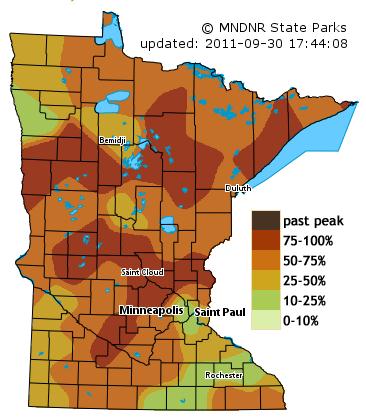
Best Weekend For Fall Color Peepers? This is it - I have a (very) strong hunch that if you wait until next weekend you may be disappointed, colors past peak over much of central and northern Minnesota. Today and tomorrow should be ideal for fall-color-gawking with blue sky, light winds, and colors close to peak color from the northern/western suburbs of the Twin Cities to St. Cloud, Little Falls and the Brainerd Lakes area to the North Shore of Lake Superior. More details from the Minnesota DNR
here.
Driest September On Record For MSP. Continuing a trend started in August - September was much drier than average across much of western and southern Minnesota. Here is an excerpt from Mark Seeley's
WeatherTalk post: "
September was a drier than normal month across nearly all of the state, especially western and southern counties. Many observers reported less than 1 inch of rainfall. One of the few observers reporting above normal rainfall was Grand Meadow in southeastern Minnesota where they had 4.27 inches. For many September, 2011 was one of the driest in history with less than half an inch of rainfall, and measurable rain on only 4-5 days during the month. Some of these included:
0.36" at MSP Airport (driest ever)
0.25" at Marshall (2nd driest)
0.05" at Lamberton (driest ever)
0.23" at Pipestone (2nd driest)
0.39" at Chaska (3rd driest)
0.41" at Wheaton (5th driest)
0.21" at Madison (driest ever)
0.34" at Browns Valley (3rd driest)
0.36" at Milan (4th driest)
0.39" at Gull Lake (5th driest)"
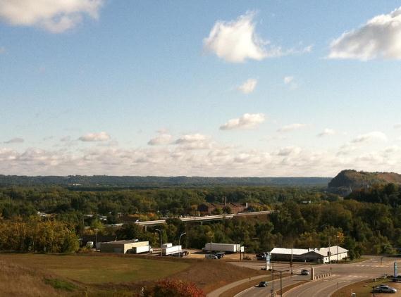
* Photo of Red Wing taken on Friday courtesy of Bernie White.
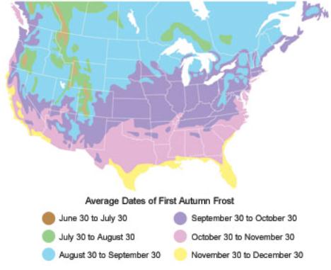
Average Date Of First Frost. Most years the first frost of the season arrives in the Twin Cities (downtown and close-in suburbs) during the first week of October.
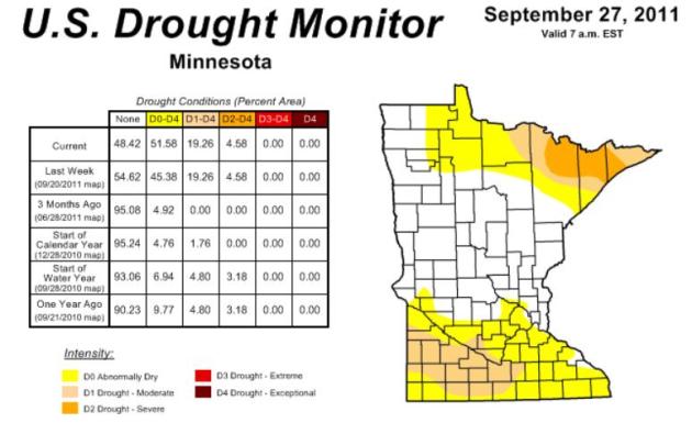
Growing Drought. I was surprised to see the latest
Drought Monitor from NOAA: 19.26% of Minnesota in a moderate drought, a little less than 5% of the state (Arrowhead) in a severe drought. After a very wet June and July rainfall went off a cliff starting in August - the dry trend accelerating into September (driest on record for MSP).
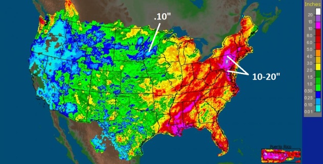
30 Day Rainfall. September has been a month of all or nothing. Parts of southwestern Minnesota picked up less than a tenth of an inch of rain, while central Pennsylvania has been inundated under 20" of rain - 6 to 7 month's worth of rain. Irene and Lee were the major culprits, but last week's stalled "cut-off" low over the Great Lakes kept a steady stream of tropical moisture flowing northward, fueling more torrential rains. Click
here to see rainfall data from NOAA.
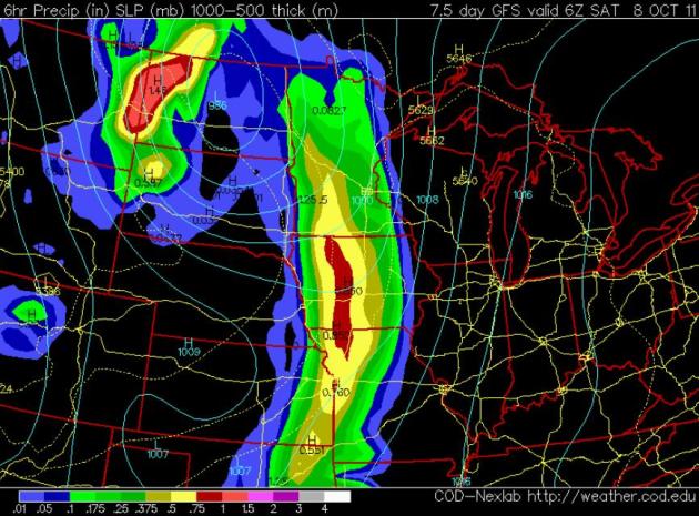
Extended Dry Spell. The next chance of rain for most of the Upper Midwest won't come until the end of next week, probably late Friday and Friday night. It's early, but the GFS model clears skies on Saturday, highs probably holding in the 60s. Again, no numbing fronts in sight - yet.
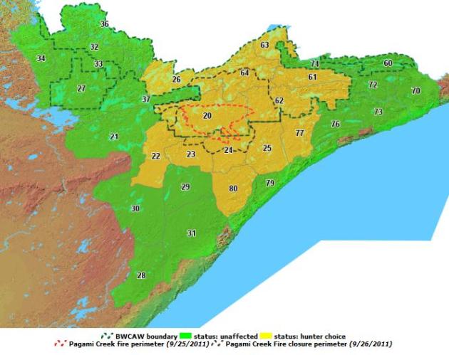
BWCA Fire Impacting Moose Hunting. The Minnesota DNR is offering hunters refunds on their licenses or have the license reinstated for future hunts if the Pagami creek fire has impacted their hunting zones. Here's the latest from the
Minnesota DNR: "
Participants in this fall's bulls-only moose hunt can chose to have their licenses refunded and reinstated for a future hunt if the Pagami Creek fire in the Boundary Waters Canoe Area Wilderness (BWCAW) has impacted or limited access to the zone in which they are authorized to hunt."
* Pagami Creek Blaze is now 67% contained. More details
here.
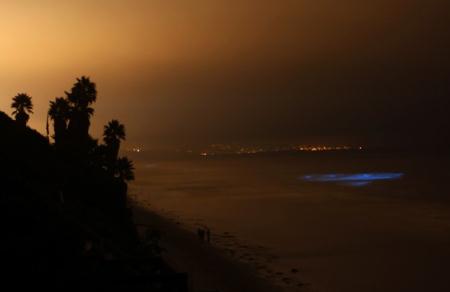
Red Tide Glows Blue Along San Diego Coast. This is a bit bizarre, strangely beautiful, but potentially bad news for sea life impacted by the red tide. Click here to read more from the
Washington Post: "
Red tide comes from an algae bloom in the bay. At night, when the algae are disturbed, by either swimmers or waves, they give off a blue light. It may be pretty, but the algae that causes this phenomena is also closely related to algae that cause shellfish harm, and in a rare case, got so thick along a French beach, that a man riding his horse was knocked out from the fumes. "
Photo credit: "
Bioluminescent phytoplankton create their own light during a red tide in the rolling surf along the coast of Leucadia, Calif. (MIKE BLAKE - REUTERS) "
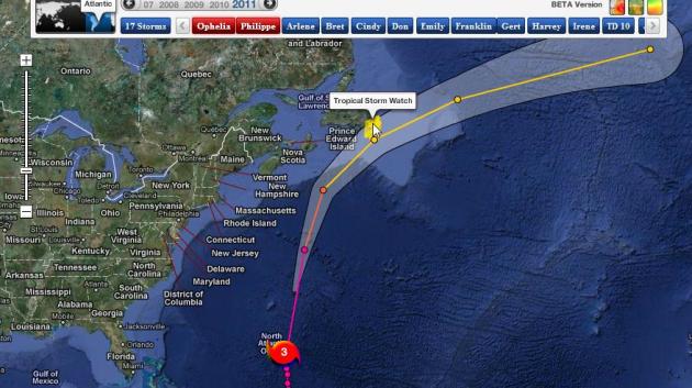
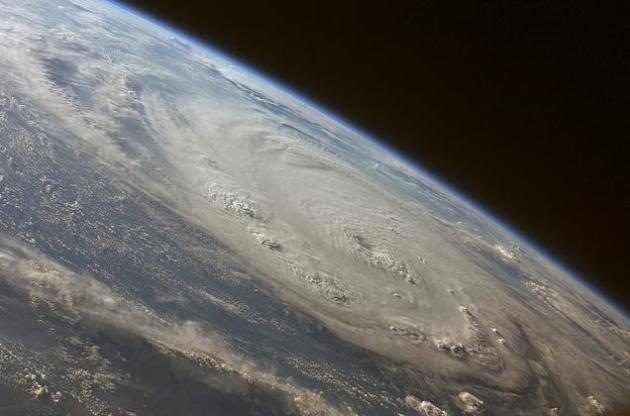
Category 4 Ophelia. On Saturday Ophelia strengthened into a rare Category 4 hurricane with 140 mph sustained winds. The core of the strongest winds and highest storm surge passed just east of Bermuda.
Ophelia Track. A Tropical Storm Watch has been posted for Prince Edward Island, in the Canadian Maritimes. Ophelia should weaken rapidly today as the storm passes over colder ocean water. Map courtesy of NHC and Ham Weather.
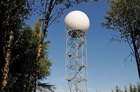
Better Storm Forecasts Coming With New Radar. It's the last buzz-word in meteorological circles. "dual-pol". Short for dual polarization Doppler radar, which does a better job detecting precipitation types, forecasting how much rain or snow may fall, even tracking the "debris ball" near the surface from a tornado.
MSNBC.com has the story: "
When it comes to storm forecasting, there's a new national leader. Washington state this week deployed an advanced Doppler weather radar that uses "dual polarization" — a technology that better predicts rain amount and even see if a twister is hiding inside a storm. By the end of October, its two other Doppler radars should be upgraded as well, making Washington the first in the nation to be fully dual polarized. The new radar is "the first addition to the nation's weather radar network since the 1990s," National Weather Service Director Jack Hayes said at the dedication on Thursday in Copalis Beach, Wash. Dual polarization, he added, provides "significantly more information and clearer pictures of precipitation and severe weather to help National Weather Service meteorologists provide more accurate and timely forecasts."
. This is a new development (made me wonder out loud if the hurricane hunter pilots may eventually be replaced by robotic drones). Hope not. Here's an article from
UPI: "
MIAMI, Oct. 1 (UPI) -- The National Hurricane Center will fly a small unmanned aircraft into hurricanes next year to improve tropical storm forecasting. The aircraft, called GALE, is shot into a storm where it gathers wind speed and other atmospheric data, the South Florida Sun Sentinel reported Friday. "It gives us a better understanding of how the ocean is interacting with the atmosphere," said Joe Cione, project leader with the National Oceanic and Atmospheric Administration. "Right now, the models are guessing at what's going on down there." The drone is 3 feet long, weighs 8 pounds and costs $30,000. GALE flies at about 55 miles per hour and can stay in the air for about 1.5 hours before falling into the ocean. "We're basically hoping this thing will last as long as it can. The wind forces will take over and cause it to rotate. But that's exactly what we want," said Massood Towhidnejad, a professor of software engineering at Embry-Riddle Aeronautical University in Daytona Beach."
In Irene's Wake, High And Dry Enough? Many New York City residents had an "oh-crap" moment when Hurricane Irene was approaching - no idea if they were in an evacuation zone or how many feet above sea level they were living. The
New York Times has more: "
WHEN Hurricane Irene roared up the East Coast this summer and drew a bead on Manhattan, hundreds of thousands of New Yorkers were surprised to learn they had something in common: They were living in Evacuation Zone A and potentially at imminent risk of being flooded out of their homes. Mayor Michael R. Bloomberg declared a state of emergency, shut down mass transit and urged some 300,000 people to flee to higher ground. But aside from some soggy streets, frayed nerves and a miserable Monday commute, New York City was spared the worst of the storm. It did, however, put a spotlight on the city’s waterfront, where in recent years, hundreds of millions of dollars of public money has been spent to improve parks, build esplanades and create the infrastructure necessary for residential development. The construction of pricey rental and condo towers along the shoreline, in neighborhoods like Battery Park City, Long Island City and Williamsburg, has transformed warehouse and wharf districts. New buildings and planned projects will add thousands of apartments over the next decade, helping ease a projected housing crunch as the city’s population balloons past nine million people." (image above courtesy of NASA).
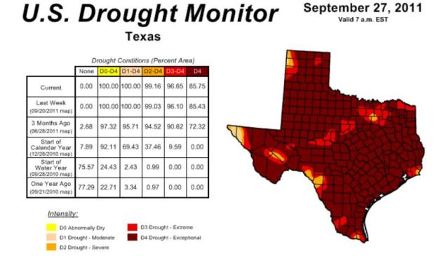
Texas Drought Could Last 9 Years. Here's a post from Dr. Jeff Masters at
Weather Underground: "The devastating Texas drought that has already cost over $5 billion could continue for nine more years, predicted Texas State Climatologist John Nielson-Gammon in an interview with
Reuters yesterday. "It is possible that we could be looking at another of these multi-year droughts like we saw in the 1950s, and like the tree rings have shown that the state has experienced over the last several centuries," Nielson-Gammon said. Drought statistics released yesterday by the
U.S. Drought Monitor showed that over 96% of Texas is experiencing the two worst categories of drought, extreme and exceptional. The past 12 months have been the driest one-year period on record in Texas. The main blame for this year's drought can be put on La Niña, the cooling of equatorial Pacific waters that deflects the jet stream and takes rain-bearing low pressure system away from Texas."
* Click here to see the latest
Drought Monitor snapshot for Texas, courtesy of NOAA.
Climate Calendar. By the end of October the average high in the Twin Cities is 50. Odds are we'll see the first flurries of the winter season by the third or fourth week of October - accumulating snow is rare, but can't be ruled out. The trend in recent years has been for milder, drier Octobers with frequent 60s, even 70s from time to time. Click
here to see all the October details, courtesy of the Minnesota State Climate Office.
 You Love Your iPhone - Literally
. Not sure if Android owners have the same sense of attachment with their smartphones, but many iPhone lovers have a special bond with their "devices". For some it's a full-blown love affair. The
New York Times has more: "
With Apple widely expected to release its iPhone 5 on Tuesday, Apple addicts across the world are getting ready for their latest fix. But should we really characterize the intense consumer devotion to the iPhone as an addiction? A recent experiment that I carried out using neuroimaging technology suggests that drug-related terms like “addiction” and “fix” aren’t as scientifically accurate as a word we use to describe our most cherished personal relationships. That word is “love.”
Climate Stories...
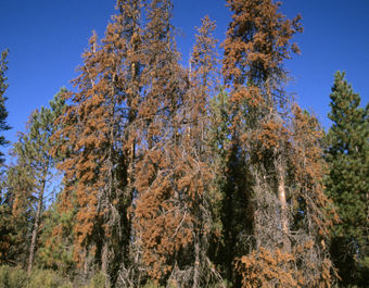
The Threats To A Crucial Canopy. What's happening to the Evergreens across the Rockies?
Could the same (deadly) beetle infestation affect Minnesota's pine trees? Here's a troubling article from the
New York Times: "
WISE RIVER, Mont. — The trees spanning many of the mountainsides of western Montana glow an earthy red, like a broadleaf forest at the beginning of autumn. But these trees are not supposed to turn red. They are evergreens, falling victim to beetles that used to be controlled in part by bitterly cold winters. As the climate warms, scientists say, that control is no longer happening. Across millions of acres, the pines of the northern and central Rockies are dying, just one among many types of forests that are showing signs of distress these days. From the mountainous Southwest deep into Texas, wildfires raced across parched landscapes this summer, burning millions more acres. In Colorado, at least 15 percent of that state’s spectacular aspen forests have gone into decline because of a lack of water. The devastation extends worldwide." (photo courtesy of
insideclimatenews.com).

Retired Republicans Quietly Try To Shift GOP Climate Change Focus. Some of my Republican brethern have actually seen the light, and are acknowledging that the GOP may be on the wrong (long-term) side of the climate story. Here are details from the
National Journal: "
To hear GOP presidential front-runner Rick Perry and some tea party-backed lawmakers tell it, the Republican position on global warming is that it’s a problem that doesn’t even exist. That wasn’t always the case. And if prominent Republican elder statesmen have their way, it won’t continue to be. Between 2005 and 2010, prominent moderate Republican Sens. John McCain of Arizona, Lindsey Graham of South Carolina, Lisa Murkowski of Alaska, and John Warner of Virginia (now retired) were among Washington’s leading voices in the call to fight climate change, and authored cap-and-trade bills aimed at addressing the problem. And they did so as leaders of their party: while running for president, chairing Senate committees, and working within the congressional leadership. Now, moderate Republicans like McCain and Graham have quieted their voices on the issue, in part because acknowledging climate change puts them out of sync with the tea party base that has so energized their party, and because climate-change legislation stands no chance of passing Congress in the current political environment. But quietly, many acknowledge a deepening GOP schism over the issue, as many moderates grow increasingly disturbed by their party’s denial of proven science. A number of influential Republicans who have left the battlefield of electoral politics are now taking action in an effort to change the GOP’s stance."

We have the technology to reduce carbon emissions even as we ramp up with traditional carbon-based fuels and renewables. But sadly we don't seem to have the political will to take the next step.
Clean Technica and Joe Romm over at Climate Progress have the (encouraging) story: "
The technology needed to cut the world’s greenhouse gas emissions by 85% by 2050 already exists, according to a joint statement by eleven of the world’s largest engineering organisations. The statement says that generating electricity from wind, waves and the sun, growing biofuels sustainably, zero emissions transport, low carbon buildings and energy efficiency technologies have all been demonstrated. However they are not being developed for wide-scale use fast enough and there is a desperate need for financial and legislative support from governments around the world if they are to fulfil their potential. That’s the news release from the UK’s Institution of Mechanical Engineers (IME), one of the 11 signatory groups. The groups explicitly call for a peak in global emissions in 2020 and an intensive effort to train workers for green technology jobs."
Why Does The Global Warming Debate Provoke So Much Anger? Good question - I've wondered the same thing. It seems like climate change threatens the way some people look at the world.
NPR.org has the story: "
My topic today is not global warming. My topic, rather, is our attitudes, thoughts and feelings about global warming. It is a striking fact that many people get very worked up over this topic. People get hot under the collar. Why is this? Ursula Goodenough took up this issue here at 13.7 a few months ago. She asked: What motivates climate change deniers? Robert Krulwich, just this past week over on his blog, wonders: Why does the climate change topic make people angry? This is a tractable metacognitive question. I'd like to venture an answer to it. Let me first begin with some preliminaries. First, the question — Why do people have such strong feelings on this topic? — is an empirical question. My proposal is merely speculative. I may be wrong. Second, the question is not merely empirical. Suppose I am locked in conflict with my significant other. I might pose the empirical question: What best explains why she is so angry with me? I might speculate as to possible causes; I might take up the standpoint of the empirical scientist bent on understanding the causes of her feeling state. Could it be hormonal? Did something happen to her at work today? Did she forget to take her medications?"
Climate Change: Will Chocolate Become A Costly Luxury? Uh oh. Don't mess with my coffee or my chocolate. Now you definitely have my attention.
Theweek.com has a story I was sorely tempted to censor (for your mental health): "
If temperatures continue to rise, a new report suggests, West Africa, source of half the world's chocolate, will be unfit to grow the coveted beans. Is the world's cocoa supply in danger? That's what a new study from the International Center for Tropical Agriculture (CIAT) suggests, singling out a familiar culprit: Global warming. The findings [see PDF] reveal that annual temperature increases will hamper the crop-production efforts in West Africa, which currently supplies half of the world's chocolate — at least if preventive measures aren't taken. Here's what you should know: How hot are we talking? The study, which consulted 19 climate-change models, indicates that a mere two degrees Celcius increase by 2050 will render areas like Ghana and the Ivory Coast too hot to grow cocoa, says The Washington Post. As cocoa trees struggle to obtain enough water, the developmental stages of cocoa pods that house "the prized cocoa bean" — source of the chocolate we know and love — would be disturbed. The effects of a shortage — including a leap in the price of chocolate — could be felt as soon as 2030. "
Ask An Aggie: Climate Change Is Real. Here's a story from
onearth.org: "
Deep in the heart of Texas, the scientific consensus is alive and kicking -- no matter what the local politicians say. For the tens of millions of Americans who are determined to "take their country back" (from what or whom exactly is still a mystery to me), there’s no climate debate. The jury is in. Global warming is a hoax, the product of a conspiracy so immense that it dwarfs anything Senator Joe McCarthy dreamed up when he was sniffing out Chinese communists in the State Department. The command posts of this conspiracy are well known by now: the leftist radicals at the United Nations; the University of East "Climategate" Anglia; and pointy-headed, elitist institutions like Princeton and Yale, Stanford and Berkeley. By contrast to these bicoastal cosmopolitans, we’ve been hearing a lot recently about the homespun heartland virtues of schools like Texas A&M, where we’re told that a talent for yelling loudly at football games is just as important as good grades -- and is held to be no impediment to the pursuit of high office. But hold on; there’s a problem with this scenario. It turns out that Texas A&M is in fact one of the nerve centers of the great climate conspiracy, together with other football-mad southern and Midwestern schools like the universities of Alabama, Nebraska, and Oklahoma, all of which are doing groundbreaking research on global warming."
Climate Skeptic Proves That He Knows How To Waste Time, Money. Media Matters has the story of Anthony Watts, one of the most vocal and shrill climate skeptics: "
Their newest descent into failure comes courtesy of one Anthony Watts, who claims to have proven conclusively that Al Gore "doctored a video that's supposed to prove his global warming theories." Here is the video, from Current TV, in which Bill Nye walks us through a simple experiment demonstrating the warming effects of carbon dioxide."