11 hours, 39 minutes of daylight on Monday. Minneapolis/St. Paul has lost nearly 4 hours of daylight since June 21, which makes 80s in early October all that much more impressive.
86 F. in 1912: Wednesday all-time high temperature record in the Twin Cities (in danger of being broken).
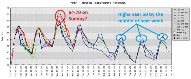
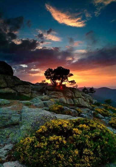
What Month Is This Again? Believe it or not, the warmest weather may still be ahead of us. Models are hinting at mid 80s on Wednesday, even some upper 80s close to home. Not too shabby, considering the sun angle is equivalent to the first week of March.
* Houston, Texas has had 139 days at 90 degrees or higher so far this year. That’s more than half the days from Jan 1 to October 3, 2011. (We are now 276 days into 2011).
* Houston has also had 46 days so far this year at 100 or higher.
* The Phoenix monsoon season wrapped up with the end of September. It was the warmest on record in Phoenix, and one of the warmest in Yuma. It was also drier than normal, with 1.6″ of precipitation recorded.
* 13.32" rain at Baltimore, a new September rainfall record. The old record was 12.41" in 1934.
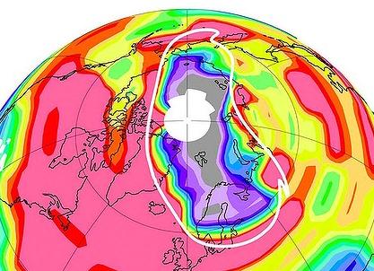
"...A hole that developed in the Earth's protective ozone layer over the Arctic this year was the largest ever recorded in the Northern Hemisphere and spread over parts of northern Russia, Greenland and Norway, the journal Nature reports. For the first time, the hole was comparable to one that appears regularly over the Antarctic, researchers found." (graphic above courtesy of NASA).
- from a USA Today article below.
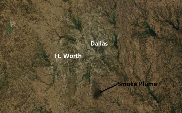
Chemical Fire From Space. The black smoke billowing from a chemical fire just south of Dallas was so massive that it showed up on satellite images - this one taken by NASA's low-orbiting "MODIS" Terra satellite, about 220 miles above the ground.
THE 2-DAY AVERAGE MAXIMUM TEMPERATURE IN WASHINGTON DC FOR THE
SAME PERIOD WAS 56.5 DEGREES…WHICH NOW RANKS AS THE COOLEST 2
DAY START IN OCTOBER. THIS SURPASSES THE PREVIOUS COOLEST OCTOBER
2-DAY START OF 57.5 DEGREES SET IN 1940. THE NORMAL AVERAGE HIGH
TEMPERATURE FOR OCTOBER 1ST AND 2ND IN WASHINGTON IS 73.5 DEGREES.
...RECORD PRECIPITATION AT BINGHAMTON NY...
PRECIPITATION AT THE BINGHAMTON REGIONAL AIRPORT IN NEW YORK NOW
STANDS AT 57.85 INCHES FOR THE YEAR UP TO AND INCLUDING OCTOBER 1ST.
THIS IS THE WETTEST YEAR ON RECORD. THE PREVIOUS RECORD WAS 49.78
INCHES IN 2006.
...WETTEST SEPTEMBER ON RECORD AT BALTIMORE MD... A RECORD MONTHLY RAINFALL OF 13.32 INCHES WAS SET FOR SEPTEMBER ATBALTIMORE IN 2011. THIS BREAKS THE OLD SEPTEMBER RECORD OF 12.41 SETIN 1934.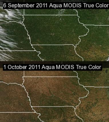
From Green To Brown. The Iowa Environmental Mesonet has a couple of satellite photos that show the progression of the seasons, the transition from greens to (mostly) browns: "Clear skies overhead this weekend give satellites a great look at the ground to show what has happened to our landscape over the past month. The featured image is of Aqua MODIS true color imagery from 6 September and 1 October of this year. Our lush green landscape has been replaced by the brown shades of fall. This color change is important as it changes the albedo of the surface allowing warming to occur more rapidly. This change will be in effect this week with mostly clear skies expected to push temperatures to near 80."
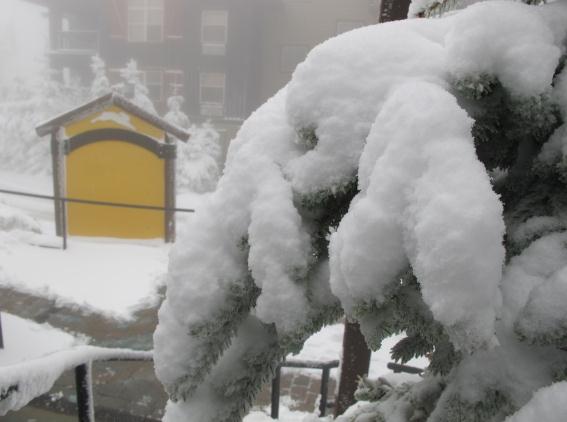
Skiers Are Happy. This photo was taken at the Snowshoe Ski Resort in West Virginia, where a whopping 9" of snow has fallen.
********************STORM TOTAL SNOWFALL********************

LOCATION          STORM TOTAL    TIME/DATE    COMMENTS
                     SNOWFALL       OF
                     (INCHES)   MEASUREMENT

PENNSYLVANIA

...BLAIR COUNTY...
   ALTOONA                  T    610 AM    10/2   NWS EMPLOYEE

...CAMBRIA COUNTY...
   EBENSBURG               1.0   730 AM    10/2   WEBCAM
   WESTMONT                 T    730 AM    10/3   COCORAHS
   BELMONT                  T    730 AM    10/2   COCORAHS
   PRINCE GALLITZIN SP      T    700 AM    10/2   COOP

...CENTRE COUNTY...
   PHILIPSBURG             1.2   700 AM    10/2   COOP
   STATE COLLEGE            T    630 AM    10/2   NWS EMPLOYEE

...ELK COUNTY...
   SAINT MARYS 2 SE         T    700 AM    10/3   COCORAHS
   RIDGWAY                  T    700 AM    10/2   COOP

...MCKEAN COUNTY...
   KANE                     T    700 AM    10/2   COOP

...SOMERSET COUNTY...
   LAUREL SUMMIT: 2.2" SNOW
   SOMERSET                 T    800 AM    10/2   COOP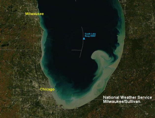
Huge Waves Stir Up Silt, Sediment, Over Southern Lake Michigan. Last week's Alberta Clipper whipped up 50-65 mph winds over the Great Lakes, resulting in wild winds that stirred up Lake Michigan. More from the Chicago NWS: "The intense northerly winds that blew though the Great Lakes region late last week, caused the silt in the southern portion of Lake Michigan to become churned up, increasing the lake turbidity to extremely high levels. The Moderate Resolution Imaging Spectroradiometer (MODIS) instrument on NASA's Terra polar orbiting satellite captured this high resolution image over Lake Michigan around noon on Sunday, October 2, 2011. Note how the "muddy" waters get caught in the currents moving through the lake."
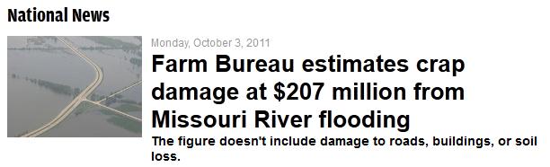
Nothing Worse Than "Crap Damage". Enough said.
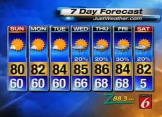
Avoid Orlando Until Further Notice. Now that it’s officially Fall, meteorologists are forecasting cooler temperatures — much cooler, according to a weather graphic on WKMG in Orlando. During the 11:30 p.m. newscast on Saturday night, meteorologist Elizabeth Hart used this weather graphic (pictured, right), which lists the low temperature next Saturday as 5 degrees, twice. “Apparently, Saturday it’s going to be 5,” anchor Eric von Ancken said with a laugh at the end of the newscast. “We’ll have to fix that for the morning.” (story courtesy of mediabistro.com).
Best Week of Autumn!
I know, meteorologists should be impartial: no such thing as good weather or bad weather. Any day you can drag yourself to the window and look out is a "good day". Right. I just can't help myself. The next few days will be a poem, an amazing symphony of elements - nature in perfect harmony. Cue the ripening leaves, neon-blue sky, crisp humidity and...80s? This is typical weather for the first or second week of August, not early October. Impressive, considering the sun will be as high in the sky today as it was back on March 5. We'll be 5-8 degrees away from all-time records through the end of this week, what will probably wind up being the most spectacular week of autumn from the Twin Cities and Chicago to St. Louis and Kansas City. Meanwhile 5"+ snows have smacked the mountains of West Virginia, and over a foot of new snow may plaster the Sierra Nevada range of California as a major Pacific storm swirls ashore. BTW, the northeast will FINALLY start to dry out - Indian Summer returns by Thursday and Friday - some 70s are on the way. Patience.
Why the taste of late summer? An "Omega Block" (storms stalled on either coast, a warm, bloated ridge of high pressure stalled over the Plains) is responsible for a fantastic holding pattern over the nation's midsection. Yes, if you squint and close one eye - the upper level wind pattern vaguely resembles the Greek letter "omega". Can you tell I'm bored?
No pity, please. My fat feet are propped up on my (unplugged) Doppler radar... camera in hand...one last chance to antagonize neighbors by strutting around in my shorts. Woo hoo!
Climate Stories...
"Nature" Reports Largest Ozone Hole Ever In North America. The story from USA Today: "A hole that developed in the Earth's protective ozone layer over the Arctic this year was the largest ever recorded in the Northern Hemisphere and spread over parts of northern Russia, Greenland and Norway, the journal Nature reports. For the first time, the hole was comparable to one that appears regularly over the Antarctic, researchers found. The ozone layer in the upper stratosphere provides a shield against UV radiation from the sun that can cause skin cancer and cataracts. Authors of the report, released today, show that the hole opened over northern Russia, parts of Greenland, and Norway in March, subjecting people there to high levels of the UV radiation. As reported by The Guardian, the researchers found that the unsually large hole was not due to man-made causes, rather to unusually strong wind patterns at high altitudes and intense cold."

"Ozone Hole". Image credit: "A NASA image shows an ozone hole five times the size of California which opened over the Arctic this (Northern hemisphere) spring that has opened over the Artic. [The red colors represent large ozone concentrations.] Photo: AFP/NASA/JPL" The Sydney Morning Herald has much more information here.
"Unprecedented" Ozone Hole Opens Over Canadian Arctic. Another angle to the ozone depletion story, this time from Canada's National Post: "A massive Arctic ozone hole opened up over the Northern Hemisphere for the first time this year, an international research team reported Sunday. The hole covered two million square kilometres — about twice the size of Ontario — and allowed high levels of harmful ultraviolet radiation to hit large swaths of northern Canada, Europe and Russia this spring, the 29 scientists say. The discovery of the “unprecedented” hole comes as the Canadian government is moving to cut its ozone monitoring network. Environment Canada scientist David Tarasick, whose team played a key role in the report published Sunday in the journal Nature, is not being allowed to discuss the discovery with the media. Environment Canada told Postmedia News that an interview with Tarasick “cannot be granted.” Tarasick is one of several Environment Canada ozone scientists who have received letters warning of possible “discontinuance of job function” as part of the downsizing underway in the department. In Sunday’s report Tarasick and his colleagues say the “chemical ozone destruction over the Arctic in early 2011 was — for the first time in the observation record — comparable to that in the Antarctic ozone hole.”
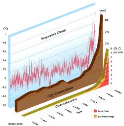
Global Temps. Spiking Faster Than Nature Can Adapt. Here's an article from Catholic Online: "Although some people still refuse to accept it, global warming is a fact. All national science academies of all the major industrialized nations of the world unanimously agree that global warming is taking place. What is still subject to debate is just how much are humans contributing to the problem and how much of it is simply being caused by nature. And more importantly, what should we do about it? LOS ANGELES, CA (Catholic Online) - Earth's temperature has fluctuated dramatically over millions of years and there have been times when the average global temperature has been much higher or much lower than it is today. Scientists know that some of the warming and cooling process is entirely natural. However they have noticed a sharper than normal increase in global temperatures over the past century, and they believe unequivocally that this is the result of human activity. Sharp changes in temperature are especially worrisome because organisms cannot rapidly adapt to such quick changes. Historically climate change has been a very gradual process, but this time it's occurring faster than on any other occasion in history. Evidence for climate change isn't simply found in temperature readings. Humans can easily handle a couple degrees of temperature change one way or another. However the environment cannot, without time (at least hundreds of years) to adjust. Scientists are blaming global warming for mass die offs of plant and animal life around the world."
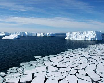
Global Warming Causes Faster Melting Of Canadian Ice Shelves. Empowerednews.com has the details: "Toronto – The 2 ice shelves that already existed before Europeans settled in Canada was seen to be already diminished as of this summer. One of the 2 ice shelves was almost completely disappearing, as confirmed by Canadian scientists. The loss signifies the worsening of global warming. The Canadian Arctic is so different few years ago as compared now, scientists added. Icebergs floating in the ocean that were already broken free might just pose risk to shipping lines and offshore oil facilities in the area. The breaking of ice shelves into smaller pieces also affects the environment for microbial life. It will also affect Canada’s coastline."