Hurricane Rina
: major hurricane with 110-115 mph winds, heading for Cancun/Cozumel, may threaten Cuba and Florida by the weekend.
6-12" snow expected in downtown Denver today - Winter Storm Warnings in effect.
I-80 closed between Cheyenne and Laramie, Wyoming, due to drifting snow.
85 degree high in Kansas City, tying a record for the latest 85 reading since 1963, 1952, &1950. Source: NOAA.
“
Tampa Bay hasn’t had a direct impact from a major hurricane for 90 years,” he said. “And, we have roughly 2.5 million people living in the area now. The potential for a catastrophe exists.” - article below on the 90th anniversary of Tampa's Tarpon Springs Hurricane.
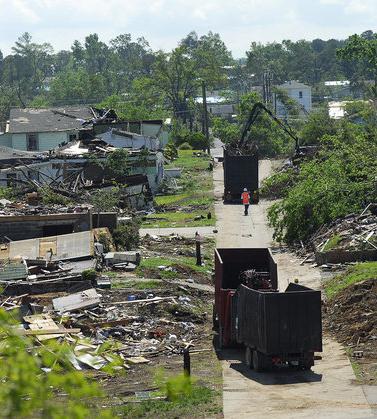
Were some of the April 27 tornadoes that destroyed so much of Alabama "unsurvivable"? The story below.
"
America and Europe face a "disaster in the making" because of Congress budget cuts to a critical weather satellite, one of Barack Obama's top science officials has warned." - article in The Guardian below.
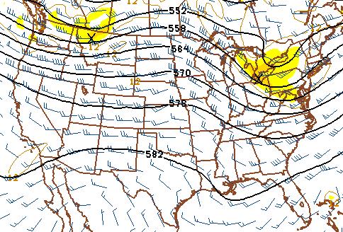
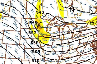 Unsettled, Showery Into Friday.
 Another clipper-like wrinkle of cold air aloft dives southeast, keeping patchy clouds and a few showers/sprinkles over Minnesota into Friday. 500 mb map above valid 4 pm Friday.
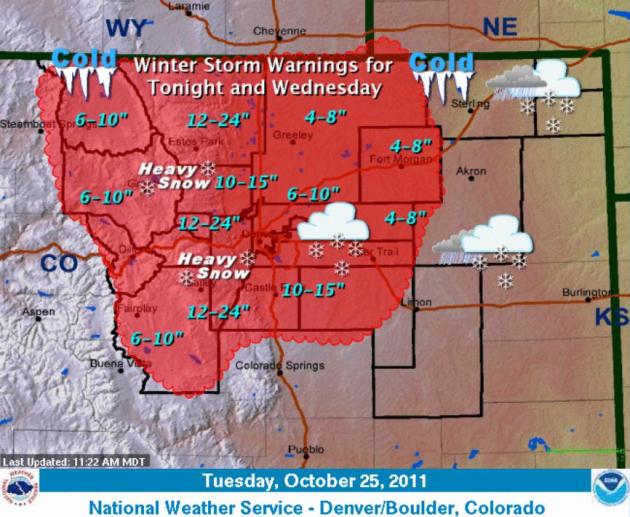 Denver: Instant Winter
. It's hard to believe the mercury soared to a record 80 in Denver on Monday. Today it will snow, heavy at times, with a potential for 4-8" on the east side of the I-25 corridor, as much as 1-2 feet for the foothills of the Rockies. More information from the Denver National Weather Service
here.
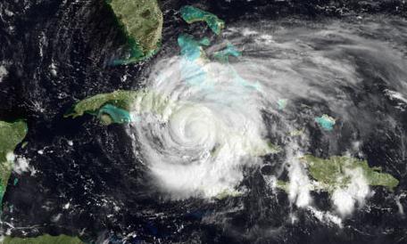
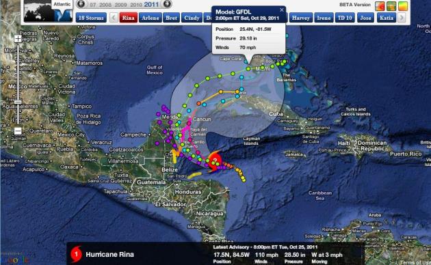 Rina: Heading For South Florida?
 It's still early and uncertainty is significant, but a number of computer solutions bring a weakened Hurricane (or Tropical Storm) Rina into the Gulf of Mexico, before taking an eastward turn toward Florida. The GFDL model has 70 mph sustained winds, just below hurricane criteria, near the Florida Keys by 2 pm Saturday afternoon. Data courtesy of NOAA
and NHC, map courtesy of Ham Weather, a division of WeatherNation.
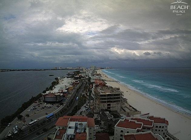
Cancun: In Rina's Path? Click
here to see a live webcam from Cancun, showing a threatening sky - weather will be going downhill rapidly over the next 48 hours. Rina could be a major, Category 3 hurricane when it approaches Cozumel and Cancun, packing 100-120 mph winds.
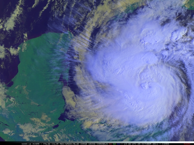
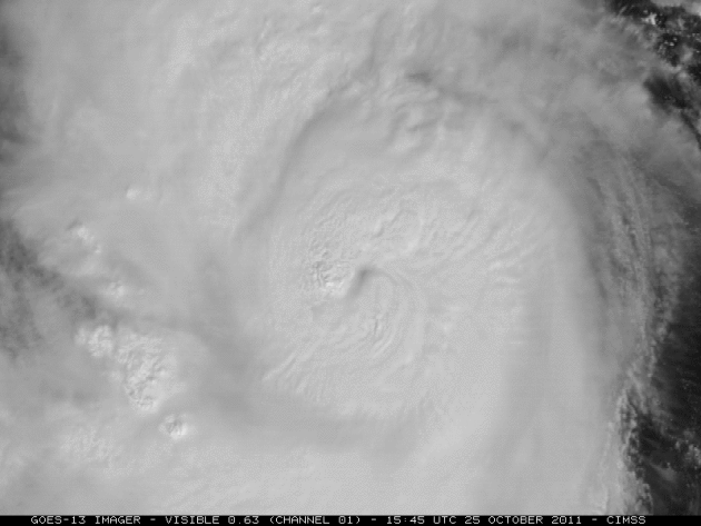
A Meteorological Mouthful. Check this out from the University of Wisconsin CIMSS web page: “
1-km resolution NOAA-16 false-color Red/Green/Blue (RGB) image of Hurricane Rina, showing lots of transverse banding.”
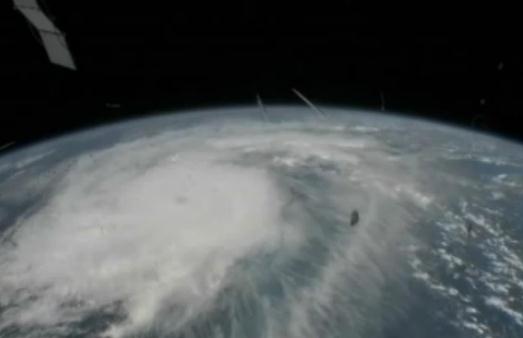
International Space Station Captures Hurricane Rina. The YouTube clip is
here - more from NASA: "
External cameras on the International Space Station captured views of Hurricane Rina at 2:39 p.m. EDT on Oct. 25, 2011, as the complex flew 248 miles over the Caribbean Sea east of Belize. The late season hurricane, which continues to intensify, was located 300 miles east-southeast of Chetumal, Mexico, barely moving west-northwest at a glacial three miles an hour. Rina is packing winds of 105 miles an hour, and is forecast to intensify to a major hurricane as it approaches the Yucatan Peninsula. Hurricane warnings have been issued for the Yucatan from north of Punta Gruesa, Mexico, to Cancun."
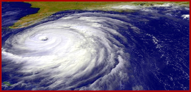
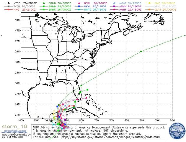 Hurricane Rina Projected Path
. The storm is forecast to slow down considerably, adding to the uncertainty. Odds favor a track over (or just south of) Florida by the weekend, but it's too early for specifics about timing and intensity. People living in Florida should stay up on the very latest forecasts and potential watches/warnings.
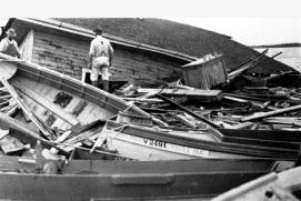
Hurricane's 90th Anniversary Serves As Grim Reminder It Can Happen Here. Tampa Patch has a good story, looking back at the Tarpon Springs Hurricane of 1921: "
Ninety years ago today, the Tampa Bay area was savaged by a Category 3 hurricane that left a wake of damage in its path. Dubbed the 1921 Tarpon Springs Hurricane, the storm was blamed for eight deaths, an estimated $5 million in damage (in 1921 dollars) and a storm surge that rose to 11 feet in height. Its fury was felt throughout the Tampa Bay area. To commemorate the anniversary of that storm, the National Weather Service’s Ruskin office has put together an online presentation about the storm. Featuring photos from the 1921 storm, facts about the damage it caused and a documentary video, the presentation is meant to remind people it can happen here, said Daniel Noah, the warning coordination meteorologist for the weather service’s Ruskin office."
* The local Tampa NWS has more on the Tarpon Springs Hurricane
here.
Hurricane Rina Strengthens, Bearing Down On Mexico's Yucatan.
Businessweek.com has more information: "
Hurricane Rina gained more strength over the warm waters of the Caribbean on a track that will take the storm toward Mexico’s Yucatan Peninsula resorts and away from the oil-rich regions of the Gulf of Mexico. Rina’s top winds grew to 105 miles (169 kilometers) per hour, up from 100 mph earlier, as it moved northwest at 3 mph, about 305 miles southeast of Tulum, Mexico, according to a U.S. National Hurricane Center advisory at 11 a.m. East Coast time. Hurricane warnings have been posted on the east coast of the peninsula from north of Punta Gruesa to Cancun. “The hurricane is situated over a region of very high ocean heat content,” the hurricane center said in a forecast analysis. “Based on the favorable environment, strengthening to major hurricane intensity appears likely.” The center forecasts that Rina’s top winds will peak at 120 mph, or Category 3 on the five-step Saffir-Simpson scale, capable of tearing roofs off houses and crumbling walls. The official track calls for the storm to close in on Cozumel and Cancun in two days before turning away from the Gulf and striking western Cuba." (visible satellite loop courtesy of NOAA).
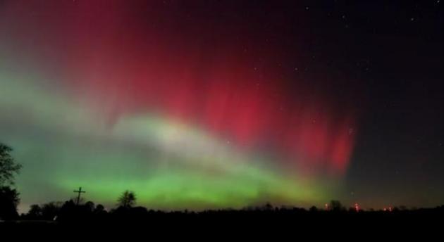
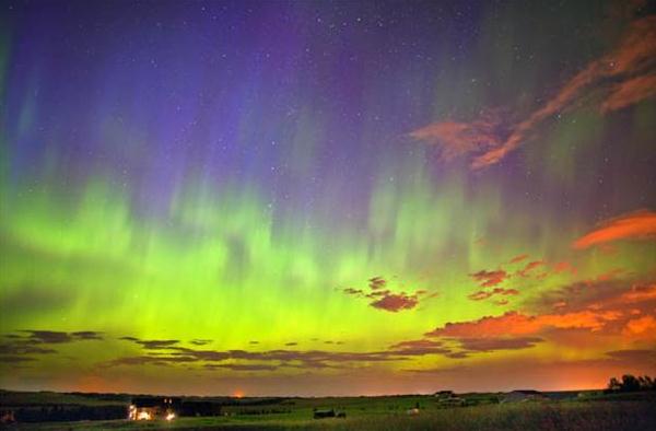
Incredible Sight. One of the many advantages of living in the Upper Midwest: you get to see the Aurora Borealis from time to time, especially during the autumn months. Michael Gavan took this remarkable time lapse
YouTube video clip in East Martin, Michigan Monday night. There's no way to predict the Northern Lights in advance, but conditions may be ripe to see more displays all week long.
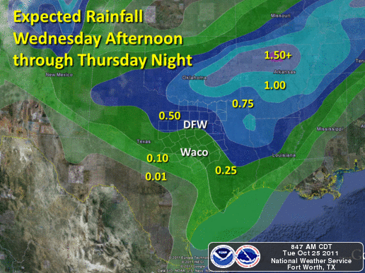
Welcome Rain For North Texas. Expected rainfall amounts courtesy of the Dallas/Ft. Worth office of the National Weather Service.
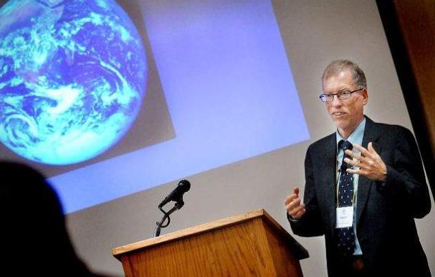
Prepare For Another Snowy Winter, Says Climatologist. UCAR climate scientist Bob Hanson recently spoke to a conference in St. Cloud. His message: a warmer, wetter atmosphere should result in a trend toward bigger snowstorms in the coming years. The Saint Cloud Times has the story: "
Henson said even if global warming continues, it will remain cold enough through much of the late fall, winter and early spring to produce snow. The ongoing effect of a rise in temperatures could be more snow along a swath from Montana through Ohio, and he showed a map of that area showing various locations that experienced one of their top five all-time snowiest winters in recent years. And right in the middle of that map is Minnesota, which last winter, Henson pointed out, had its largest December and February snowfalls on record since 1891. “The highlights are there could be bigger midwinter snows and they won’t melt away as easily,” said Henson, 51, who has written several books about weather and climate change and had articles published in Discover, Nature and Scientific American magazines. “Temperatures will still be colder in the wake of these storms and the lower sun angle of early and midwinter will make the snows stick around longer. That could lead to an enhanced spring melt.”
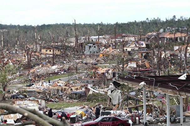
Experts Cite Need For More Shelters At National Weather Association Conference. 600 meteorologists and storm experts just met at the NWS Conference - at the top of the agenda was the incredibly destructive tornado year for Alabama and Mississippi, and what (if anything) can be done to lower the tornado toll in future storms. The
Birmingham News has more details: "
HOOVER, Alabama --- People can get spot-on tornado forecasts and take the warning to heart, but it does little good if they have nowhere safe to go, the director of Madison County's Emergency Management Agency said Wednesday. "For the first time, we have heard the term 'unsurvivable storm,'" John "Rusty" Russell said, speaking at a National Weather Association conference about the April 27 tornado outbreak. But he said the storms that hit Alabama that day might have been more survivable for many if more shelters were available. "A lot of the people who died did everything they were supposed to do ... and still got killed because we don't have the shelter capacity," he said. "Some areas have no community shelters."
Tornado Survivors Answer Questions On How They Reacted To Severe Weather Threat. The
Birmingham News conducted the poll and shares some of the eye-opening results: "
HOOVER, Alabama --- A group of about 200 tornado survivors clicked their answers Tuesday night on how they reacted to tornado threats, and some of the answers were eye-opening.
- Click -- 71 percent said they owned a NOAA weather radio on April 27.
- Click -- 67 percent on April 27 had a tornado safety plan and followed it.
- Click -- 51 percent took immediate protective action upon hearing the warnings.
Using hand-held electronic devices to click on multiple choice questions, the tornado survivors at the Wynfrey Hotel in Hoover gave their contribution to a body of study still in its infancy -- how people react to severe weather warnings, specifically tornado threats."
Raw Video: Flooding Shuts Down Bangkok Airport. Video courtesy of AP and
YouTube: "
Advancing floodwaters in Thailand shut down commercial flights Tuesday at Bangkok's second airport, spilling across a complex housing the country's flood relief headquarters."
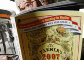
Farmers Almanac: Right As Rain Or 3 Dollar Bill? Discovery News tackles a sensitive subject: the perceived accuracy of the Farmer's Almanac. Interesting to look at, but how accurate is it? "
For nigh on to two centuries, Americans have taken a gander at farmer's almanacs for auguries about the weather. Millions of readers think they are the bee's knees but atmospheric scientists scoff at the ability of olde-tyme formulas to prognosticate the weather. "Based on my own analysis, and that of others, the monthly mean forecasts published by the 'Old Farmer's Almanac' (OFA) lack value," Nick Bond, of the National Oceanic and Atmospheric Administration and Washington's State Climatologist, told Discovery News. The "Farmers' Almanac" and the "Old Farmer's Almanac" are in competition with each other, but also face stiff competition from meteorologists with millions of dollars worth of satellites, radar dishes and other new-fangled contraptions. The "Farmers' Almanac" has weathered these scientific advances with stalwart faith in the founder's formula. "The formula we use dates back to 1818. It is a mathematical and astronomical formula that takes sunspot activity, tidal action of the moon and position of the planets into consideration. The complete formula is known only by our weather prognosticator -- Caleb Weatherbee," said Sandi Duncan, managing editor of the "Farmers' Almanac."
Weather Satellite Budget Cuts "A Disaster In The Making" - Obama Official. Here's an update on NOAA technology that may or may not be on the budget chopping block from the U.K.
Guardian: "
America and Europe face a "disaster in the making" because of Congress budget cuts to a critical weather satellite, one of Barack Obama's top science officials has warned. The satellite crosses the Earth's poles 14 times a day, monitoring the atmosphere, clouds, ice, vegetation, and oceans. It provides 90% of the information used by the National Weather Service, UK Met Office and other European agencies to predict severe storms up to seven days in advance. But Republican budget-cutting measures would knock out that critical capacity by delaying the launch of the next generation of polar-orbiting satellites, said Jane Lubchenco, who heads the National Oceanic and Atmospheric Agency. "It is a disaster in the making. It's an expression of the dysfunction in our system," said Lubchenco, who was speaking at a dinner on the sidelines of the Society of Environmental Journalists meeting in Miami. It would cost three to five times more to rebuild the project after a gap than to keep the funds flowing. "It's insanity," Lubchenco said."
Weather Expert Uncovers Hurricane Myths, Exposes Truths. Direct from the
Baylor Lariat: "
Dr. Steve Lyons, the former Tropical Weather expert on The Weather Channel, explored the “Five Toes of the Hurricane Footprint” in a seminar Thursday evening in the Baylor Sciences Building. Lyons said the five toes are wind, waves, water rise, flooding rain and tornadoes. Lyons said a misconception about hurricanes is that their biggest threat is wind. According to the National Hurricane Center website, hurricanes are categorized by the Saffir-Simpson Hurricane Wind Scale from Category 1 to Category 5, where one is the least severe and five is the most severe in terms of wind speed and storm surge. Lyons said the wind speed doesn’t say much about what’s going to happen, and that all five toes have to be considered in gauging the possible impact of a hurricane. “If you can paint a picture of what’s going to happen before it happens, you’ve done a fabulous service,” Lyons said." (NASA file photo above of Hurricane Floyd).
 Dry, Pleasant Halloween For Much Of America
. Showery rains are possible next Monday for New England (some wet snow for the highest elevations?) The rest of the USA should be dry, unseasonably mild weather from Chicago, Des Moines and the Twin Cities westward to Denver, Salt Lake City and Dallas.
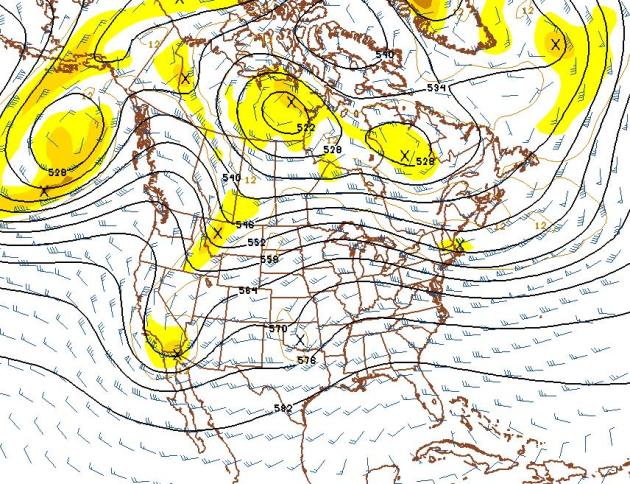 Slow-Motion Autumn
. The 500 mb map above is valid November 10. I still don't see any signs of a high-amplitude pattern (deep troughts or ridges) - capable of whipping up major storms. With a strong zonal, west-to-east wind flow aloft, most of America will enjoy a modified-Pacific airmass, temperatures trending warmer than average through the first weei, possibly 2 weeks of November, with the coldest Arctic air remaining bottled up well to the north over northern Canada. No wintry jabs are imminent.
"Unsurvivable Storms"
Today's weather blog delves into the topic of large, violent tornadoes - how some worst-case twisters may be "unsurvivable" unless people have access to basements. An estimated 2/3rds of Alabama residents have no below-ground shelter. 166 tornadoes struck Alabama in 2011, most in the USA.
The St. Cloud Times highlights UCAR climate scientist Bob Hanson, who is predicting snowier winters from Montana to Ohio; with more big slushy snows in November and December - symptoms of a warmer, wetter atmosphere?
Tell that to residents of Denver, living through a wild week. Hard to believe it was a record 80 F. on Monday. Today Denver residents will dig out from 4-8" of snow, more over the western foothills. From shorts to shovels in 36 hours!
Climate Stories...
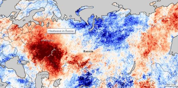
Russian Heat Wave Statistically Linked To Climate Change. Wired.com has the story: "
A new method of crunching climate data could make it possible to put a figure on climate change’s contribution to freak weather events, something that’s been difficult to do with empirical precision. The debut subject: the Russian heat wave of July 2010, which killed 700 people and was unprecedented since record keeping began in the 19th century. According to the analysis, there’s an 80 percent chance that climate change was responsible. “With climate change, it’s going to happen five times more often than without,” said climatologist Stefan Rahmstorf of Germany’s Potsdam Institute for Climate Impact Research. While the influence of climate trends on weather is recognized as “loading the dice,” making extreme events more likely, individual events are still described in general terms of fitting patterns. The new method, described by Rahmstorf and Potsdam geophysicist Dim Coumou in an Oct. 25 Proceedings of the National Academy of Sciences study, relies on a computational approach called Monte Carlo modeling. Named for that city’s famous casinos, it’s a tool for investigating tricky, probabilistic processes involving both defined and random influences: Make a model, run it enough times, and trends emerge. “If you roll dice only once, it doesn’t tell you anything about probabilities,” said Rahmstorf. “Roll them 100,000 times, and afterwards I can say, on average, how many times I’ll roll a six.”
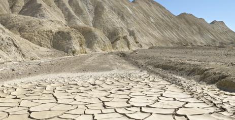 Flawed USGS Study Still Links Southwest Drying To Increasing Carbon Dioxide Pollution And Climate Change. Climate Progress
 has the analysis and story: "
A new U.S. Geological Survey analysis finds that, as climate scientists have been predicting for decades, the Southwestern U.S. appears to be drying in part because of rising levels of carbon dioxide:
The decrease of floods in the southwestern region is consistent with other research findings that this region has been getting drier and experienced less precipitation as a likely result of climate change.
The study, “Has the magnitude of floods across the USA changed with global CO2 levels?” appearing in Hydrological Sciences Journal, however, relies on dubious and “absurd” assumptions, according to a number of climate scientists I spoke. Amazingly, the lead author seems to lack an understanding of core issues germane to his analysis, as we’ll see. The finding about SW drying that I’ve focused on isn’t the focus the main spin the USGS and media have given the study. The USGS focused on what they claim is the lack of a “significant relationship between carbon dioxide (CO2) in the atmosphere and the size of floods over the last 100 years” in the three other regions they rather arbitrarily divide the country into — northeast, southeast, and northwest."
Climate Change: What We do - And Don't Know. Newscientist.com has the story: "
There is much we do not understand about Earth's climate. That is hardly surprising, given the complex interplay of physical, chemical and biological processes that determines what happens on our planet’s surface and in its atmosphere. Despite this, we can be certain about some things. For a start, the planet is warming, and human activity is largely responsible. But how much is Earth on course to warm by? What will the global and local effects be? How will it affect our lives?"