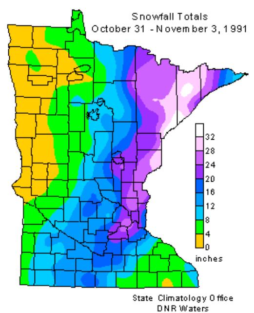
 Halloween Superstorm Facts
. The 20 year anniversary is coming up - and some of the all-time Twin Cities records are listed above. Minnesotans have plenty of Halloween 1991 memories (and horror stories). In the coming days we'll review one of Minnesota's most remarkable snowstorms....ever. Data above courtesy of the
MN State Climate Office.
 2.5" snow
 at Amarillo, Texas Thursday morning.
4-8" snow reported in downtown Denver and close-in suburbs; most of that snow will be gone by this evening.
57.68" precipitation at Cincinnati, Ohio: wettest year on record (old record: 57.58" in 1990).
* Is it time to have two types of tornado alerts, 1). Tornado Warnings and
2). Tornado Emergencies? I try to make the case below.
 Freak October Snowstorm?
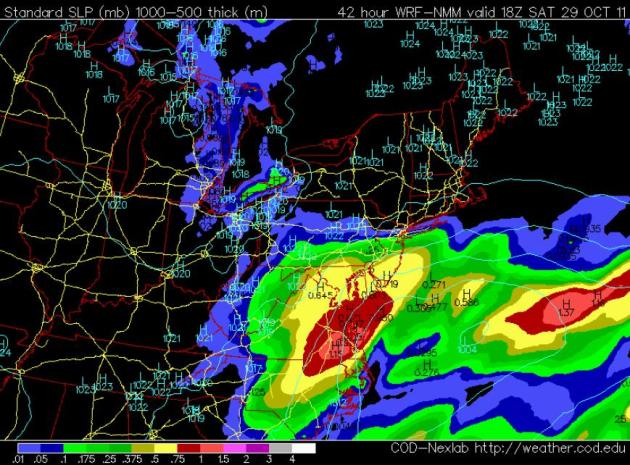
 The latest guidance is in, and I almost fell off my couch last night. Models consistently print out a second, coastal storm Friday night into Saturday, and there may be enough cold air in place for mostly snow. It's hard to believe, but there's a potential for a heavy, wet ("plowable") snowfall from Richmond to D.C., Baltimre and Philadelphia. A few of the computer models are hinting at a foot of snow for some of the major population centers in the Mid Atlantic states. Good grief - this is all happening a little too quickly...
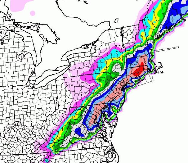
 Saturday Snow Blitz?
 Man, I
hope the models are wrong. This is pretty incredible - models now suggesting that enough cold air will be in place for mostly snow as a coastal storm pushes north Friday night into Saturday, a fast-moving shield of snow falling at the rate of 1"/hour, from near Richmond to Washington D.C. to Philadelphia, the suburbs of New York City, to Hartford. The Twin
Cities has yet to see a flake of snow, and our nation's capital and the Big Apple may be digging out from at least 10" snow by Saturday evening.
Surreal. Let's see if the models are on the right track. Stay tuned.
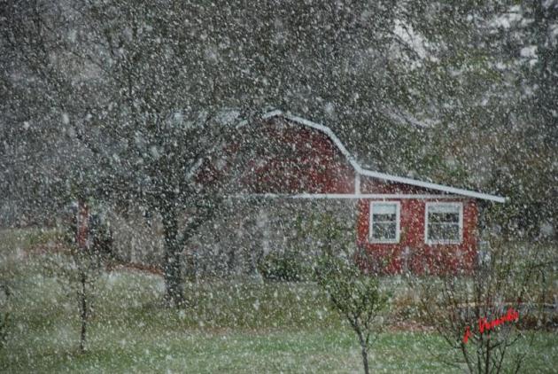
Wisconsin Snow Burst. “Thanks to Jerry Veverka for sending us this pic of snow falling 5 miles southwest of Phillips, WI.” (source: Duluth National Weather Service).
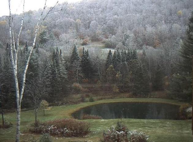
First Snow. NWS Burlington VT: “First images of snow this morning across central and southern VT as well as the southern Adirondacks. This image is from a web cam near Chelsea, VT. Mainly light amounts of snow today with up to an inch or two in the higher elevations of the southern Green Mts.”
Rina Weakens To Tropical Storm As It Approaches Yucatan Peninsula.
Reuters has the latest: "
Hurricane Rina weakened to a tropical storm on Thursday as it swept toward Mexico's Caribbean coast after causing travel chaos and spurring evacuations from island resorts. Rina is expected to continue to weaken as it sweeps the eastern coast of the Yucatan peninsula by evening, the Miami-based National Hurricane Center said. The coast is home to the strip of resorts known as the Riviera Maya. In Playa del Carmen, strong rain had eased by the morning although the sea was choppy and the dock for ships to the tourist island of Cozumel was closed. While most souvenir and gift shops on the pedestrian boulevard 5th Avenue had their steel shutters drawn, only a few beach-front properties had their windows secured with wooden panels. "
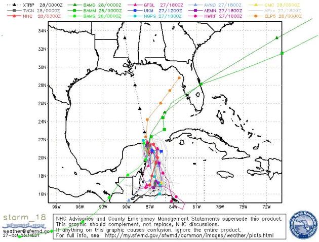 Rina's Track.
 There's a good chance Rina will weaken into a tropical depression and do a U-turn, soaking the Yucatan Peninsula, but sparing Florida in the process. Too much wind shear, too much dry air being entrained into the storm's circulation.
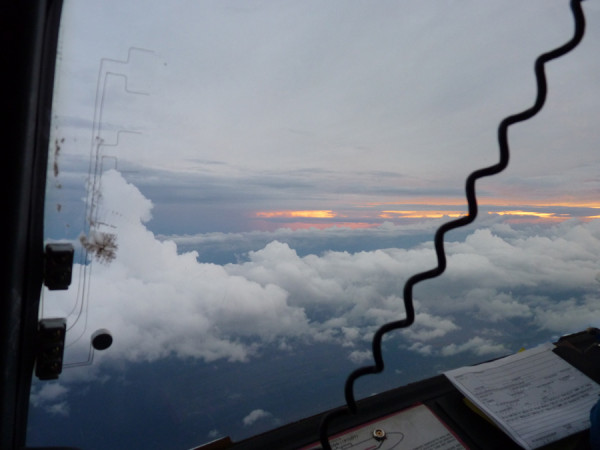
Hurricane Hunter Pics. The USA is the only country that flies planes INTO hurricanes, to learn more about intensity and future track. Every hurricane is different, and only so much data can be gleaned from weather satellites. These big, 4-engine, turboprop aircraft send back real-time information to NHC, launching "dropsondes", small weather instruments that parachute to the ocean floor below, sending back a live data stream of wind, pressure and humidity all the way down. (Thanks to Justin Kennedy from NOAA for tweeting the photos above).
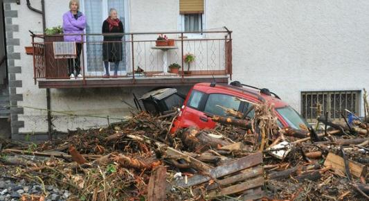
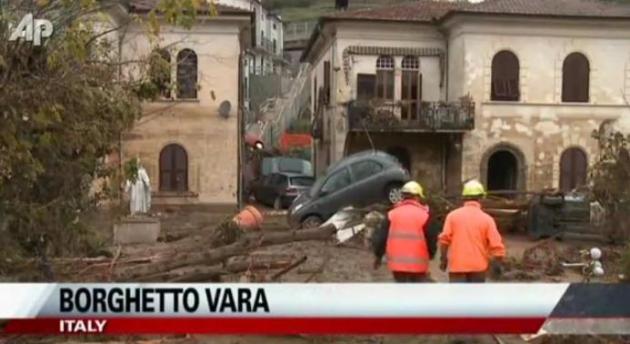
Mudslides And Flooding Ravage Areas Of Scenic Beauty In Italy. The
New York Times has more details: "
ROME — Flailing through mounds of sludge left by torrential rains, rescue workers cleared debris and hunted for survivors in Tuscany and Liguria on Wednesday after mudslides and flooding left at least six people dead and hundreds homeless in those areas, among the most picturesque in Italy. Video images showed vast devastation, including in Monterosso al Mare, a village on the Unesco World Heritage List. In some towns, videos showed, streets had become canals, furniture was piled pell-mell outside homes, bridges were swept away, highways were blocked by tree trunks and overturned trucks, cars were washed out to sea and boats were shredded like matchsticks."
Hurricane Tracker. Here's a very cool visualization of "Rina" from the
New York Times, showing past and predicted track, along with a "meteogram" to the right, with the change in intensity over the last few days.
Hurricane Photos. The
New York Times has done a very good job soliciting and posting hurricane-related photos. Man of these photos are from Hurricane Irene, but some pics from Tropical Storm Lee are included as well. Definitely worth a look.
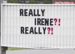
Hurricane Irene Victims Are "Still Really Suffering". WRAL-TV has an update on the lingering impact of Irene: "
Aurora, N.C. — It has been two months since Hurricane Irene hit parts of eastern North Carolina, and, in many places, the cleanup is far from over. In Beaufort and Pamlico counties, flooding was a big part of the problem, leaving homes and businesses uninhabitable. At Carolina Seafood in Beaufort County, workers have been shaping the company back to what it was before the storm. There wasn't much left of the crab processing company following the hurricane. “I just went to my knees and cried,” said Vance Henries, owner of Carolina Seafood. “Walls were busted in. We had trees – floating trees – that had come in like torpedoes and just took walls out.” With nowhere to process the crabs, most of the employees had to look elsewhere for work. Employee Janet Diffenderfer says, after a hurricane, “elsewhere” is hard to find. “No (one was) hiring. They weren’t even hiring before the hurricane hit,” she said."
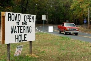
South Jersey Businesses And Residents Still Feeling The Effects Of Hurricane Irene.
PressofAtlanticCity.com has the story: "
HAMILTON TOWNSHIP — A few days after Hurricane Irene struck South Jersey last month, a group of FEMA employees visited Byron Rovins at his Watering Hole Cafe on Weymouth Road here and asked how he had fared in the storm. “I said, ‘There’s no damage, but no one is driving by,’” — due to the closing of the Weymouth Road bridge three-and-a-half miles from his business — Rovins said. Six weeks later, Rovins is still feeling the impact of Irene, as he waits for the bridge to be repaired and his customers to return. “Maybe it would have been better if I had some damage,” Rovins said, jokingly. But there’s some truth to what Rovins was saying. South Jersey was spared the brunt of Irene, although the hurricane did cause severe flooding in the township and the northwest section of Atlantic City. But, still, the damage was light compared with problems in North Jersey, and as a result, fewer disaster loans from the U.S. Small Business Administration have been made here."
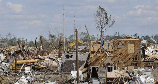
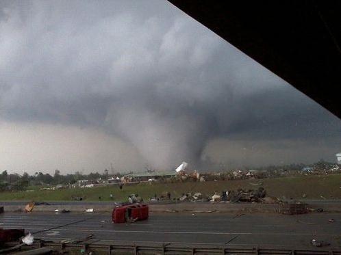
National Effort Ongoing To Improve Severe Weather Warning Network. The
Montgomery Adviser has a look at weather technology and ways to improve the tornado warning process. Doppler radar (and now dual polarization Doppler) has become so sophisticated that we can see circulations within thunderstorms we never saw before. But only 20% or so of rotating thunderstorms go on to spawn tornadoes. The NWS wants to err on the side of caution and safety (smart idea) but this means a lot of false alarms go out to the public. My proposed solution? Call it a tornado warning (if it's based on rotation on Doppler radar). If it's an actual tornado on the ground, a confirmed funnel causing damage - call it something else, call it a "Tornado Emergency", another level of urgency - something to SHAKE PEOPLE and make sure they take action. The sobering lesson of Joplin: sometimes, even if people do the right thing and ride out a tornado in a basement or underground shelter - it can still not be enough. If it's an EF-4 or EF-5 the odds of survival are much lower, even in a basement. Thankfully less than 2% of all U.S. tornadoes are EF-4 strength or higher.
Some people will rightfully point out that having 2 different kinds of tornado alerts will be confusing, and it's hard to argue with that. Some people may hear a (rotation-based) tornado warning and sit on their hands, do nothing until or unless it turns into a full-blown tornado emergency with circulation reaching the ground. I'm not sure if there's a perfect solution here - but the more I think about this the more I believe there should probably be some way of distinguishing between rotation-based tornado warnings, and more urgent situations where rotation is accompanied by reports of a tornado on the ground from SKYWARN and law enforcement. To me the notion of a Tornado Emergency makes sense, and imparts an additional level of urgency the public probably needs to do the right thing.
"
On the evening of April 27, in the midst of a massive tornado outbreak in Alabama, Lee Schaffer felt he would have plenty of time to get his family out of their mobile home and to their safe area -- his parents' house -- if a twister struck. He was wrong. When the tornado warning went out for Elmore County, the Santuck resident gathered his wife and four children, all younger than 5, and went next door. "We had been under tornado warnings several times before and had never been hit by a tornado," he said. "I wouldn't say we were ignoring that warning that night, but you think you would hear the tornado coming and you would have time to get someplace safe."But it was at night, you couldn't see it coming. It didn't make a freight train like sound, just a low, eerie hum."
Italy Digging Out After Flash Flood Devastation. AP has some
incredible footage in this YouTube story. Reports of 20" of rain in less than 12 hours, resulting in widespread mudslides and flash flooding. At least 9 deaths are being blamed on the freak floods; the death toll expected to rise in the days ahead: "
Italians were digging out Thursday from under the debris piled up by flash flooding and mudslides in the normally picturesque northwestern region. The death toll climbed to at least nine, with several still missing."
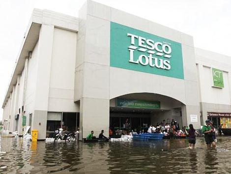
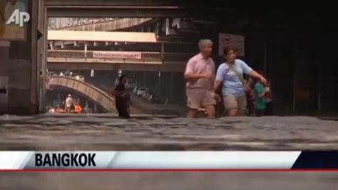
Flood Waters Move In On Bangkok.
Voice of America and AP have an update: "
Thai authorities say flood waters creeping down from the north could soon swamp the Thai capital, Bangkok, leading thousands of people to leave the city. Thai monks, soldiers, and local people hammered particle boards in between two concrete walls along Bangkok’s Chao Phraya River. They dropped sandbags into the space between the walls, extending the height by about half a meter. The hope is that the makeshift barrier will prevent, or at least slow down, flood waters from entering the Kaew-Fah-Chulamani temple. Phra Rattanamaythee, head monk at the temple, says he thinks the mass of water headed to Bangkok will probably spill over the wall. But, he says as long as the water is not too high they can still live on the temple’s second floor. He says the flood disaster is worse than in past years. The government and people tried to prevent it, but the water mass is a larger amount this time. He says they have used all of their personnel and equipment, but could not stop the water. He says they have done their best."
Residents Escape Bangkok Flooding. Another perspective on the worst flooding in 50 years from the
Washington Post: "
Parts of Thailand's flood-threatened capital are rapidly emptying of residents who are listening to a government warning to use a special five-day holiday to escape the danger."
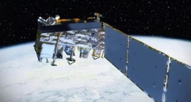
NASA - NPP: Final Steps To Countdown. NASA is about to launch a new satellite that will revolutionize the monitoring of weather and climate from low-Earth orbit. Here's a good
YouTube explainer: "
NPP is nearly ready to be launched! This video describes the final steps for this Earth-observing climate and weather satellite before it launches, currently scheduled for the morning of Oct. 28, 2011."
 Poodle + Zombie = Zoodle
. With Halloween fast approaching here's a timely nugget, courtesy of
Neatorama.com: "
What do you get when you cross a poodle with a zombie? A Zoodle! Via Daily Dawdle"
Climate Stories...
 Jon Stewart Rips Media For Ignoring "Climategate" Debunking, Covering McRib Instead
. This is classic. Thank God for Jon Stewart - doing what CBS, NBC and ABC SHOULD be doing. Who would have thought that some of our best journalism would come from a cable comedy show, but you have to give credit where credit is due. Huffington Post, Hulu and Comedy Central bring you the story (and
must-see video clip): "
On Wednesday night's "Daily Show," Jon Stewart picked up on a story that rocked the science world in 2009: the email hacking that exposed hundreds of exchanges between global warming scientists known as Climategate. If you remember, the emails weren't a big deal because they proved anything, but because they suggested irregularities in data which in turn encouraged climate change skeptics to continue to deny global warming. As Stewart reminisced with a series of clips, Fox News pundits and conservative analysts on all the 24-hour news networks had a field day proclaiming that these emails proved global warming was a fraud. And it worked, too. As Stewart pointed out, studies show the amount of people who acknowledge global warming dropped nearly 20% since the emails were leaked. Given the media circus that was Climategate, Stewart was shocked to learn that a study done by a noted climate change skeptic AND funded by Tea Party oil tycoons the Koch brothers which intended to disprove global warming recently reaffirmed the science behind it. What shocked him even more? How little coverage the findings, printed in a Wall Street Journal op-ed, received compared to that of McDonald's "McRib."
Climate Change Making Country's Water Problems Worse: Expert. Reuters has the story: "
Climate change and population growth in the United States will make having enough fresh water more challenging in the coming years, an expert on water shortages said on Wednesday. "In 1985-1986 there were historical (water level) highs and now in less than 25 years we are at historical lows. Those sorts of swings are very scary," said Robert Glennon, speaking at the State of the Lakes Ecosystem Conference in Erie, Pennsylvania. Glennon, a professor at Arizona State University and the author of "Unquenchable: America's Water Crisis and What To Do About It," said that that according to climate experts, shorter, warmer winters mean less ice and greater exposure to the air, leading eventually to more water evaporation."
NOAA Study: Human Caused Climate Change A Major Factor In More Frequent Mediterranean Droughts. Here's a
press release from NOAA: "
Wintertime droughts are increasingly common in the Mediterranean region, and human-caused climate change is partly responsible, according to a new analysis by NOAA scientists and colleagues at the Cooperative Institute for Research in Environmental Sciences (CIRES). In the last 20 years, 10 of the driest 12 winters have taken place in the lands surrounding the Mediterranean Sea. “The magnitude and frequency of the drying that has occurred is too great to be explained by natural variability alone,” said Martin Hoerling, Ph.D. of NOAA’s Earth System Research Laboratory in Boulder, Colo., lead author of a paper published online in the Journal of Climate this month. “This is not encouraging news for a region that already experiences water stress, because it implies natural variability alone is unlikely to return the region’s climate to normal.” The Mediterranean region accumulates most of its precipitation during the winter, and Hoerling’s team uncovered a pattern of increasing wintertime dryness that stretched from Gibraltar to the Middle East. Scientists used observations and climate models to investigate several possible culprits, including natural variability, a cyclical climate pattern called the North Atlantic Oscillation (NAO), and climate change caused by greenhouse gases released into the atmosphere during fossil fuel use and other human activities."
 Getting Angry And Going Right.
 Here's an Op-Ed from
The Economist: "
GIVEN the broad scientific consensus that climate change is happening, based on data showing that climate change is happening, climate scepticism must be predicated on a belief that the data is flawed. The paper has a look at climate data to date and the methodological limitations that have given rise to what Richard Muller, an astrophysicist, characterise as "legitimate scepticism". As the article explains, Dr Muller, being somewhat sceptical himself in the wake of the 2009 "Climategate" scandal, convened the Berkeley Earth Surface Temperature group to examine the data and existing analyses using a methodology designed to incorporate some of the concerns of the legitimate sceptics. On October 20th, the group released four papers that corroborate the climate consensus: "The group estimates that over the past 50 years the land surface warmed by 0.911°C: a mere 2% less than NOAA’s estimate." The corroboration should comfort people who are concerned about climate change, although the data are not comforting in the grand scheme of things. No doubt a lot of climate sceptics are stubborn and will not be moved by new methodological approaches. Some, however, will. And although American environmentalists are regrouping after a series of setbacks, they're hardly going to abandon the issue of climate change. Reinforced data may help as they retool their strategies."
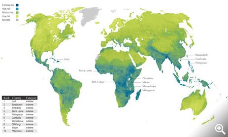
Map Shows Stark Divide In Who Caused Climate Change And Who Is Being Hit. The U.K.
Guardian has the story: "
When the world's nations convene in Durban in November in the latest attempt to inch towards a global deal to tackle climate change, one fundamental principle will, as ever, underlie the negotiations. Is is the contention that while rich, industrialised nations caused climate change through past carbon emissions, it is the developing world that is bearing the brunt. It follows from that, developing nations say, that the rich nations must therefore pay to enable the developing nations to both develop cleanly and adapt to the impacts of global warming. The point is starkly illustrated in a new map of climate vulnerability (above): the rich global north has low vulnerability, the poor global south has high vulnerability. The map is produced by risk analysts Maplecroft by combining measures of the risk of climate change impacts, such as storms, floods, and droughts, with the social and financial ability of both communities and governments to cope. The top three most vulnerable nations reflect all these factors: Haiti, Bangladesh, Zimbabwe."