October 2010 to September 2011: driest 12 month period in Texas history
Volcanic Ash In The Forecast? A new Russian volcano may threaten air travel between North America and Asia in the coming weeks. Details below.
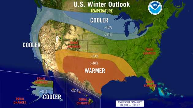
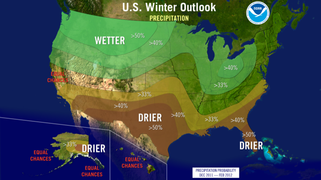
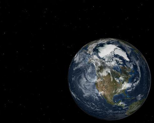
Winter Outlook From The Climate Prediction Center. NOAA released their
official winter outlook today, which shows the same trends I talked about earlier in the week - but is considerably warmer than what I predicted. La Nina is a major factor, along with atmospheric "wild cards" that may result in rapid temperature variations: "
For the second winter in a row, La Niña will influence weather patterns across the country, but as usual, it’s not the only climate factor at play. The ‘wild card’ is the lesser-known and less predictable Arctic Oscillation that could produce dramatic short-term swings in temperatures this winter. NOAA expects La Niña, which returned in August, to gradually strengthen and continue through the upcoming winter. It is associated with cooler than normal water temperatures in the tropical Pacific Ocean and influences weather throughout the world. “The evolving La Niña will shape this winter,” said Mike Halpert, deputy director of NOAA’s Climate Prediction Center. “There is a wild card, though. The erratic Arctic Oscillation can generate strong shifts in the climate patterns that could overwhelm or amplify La Niña’s typical impacts.” The Arctic Oscillation is always present and fluctuates between positive and negative phases. The negative phase of the Arctic Oscillation pushes cold air into the U.S. from Canada. The Arctic Oscillation went strongly negative at times the last two winters, causing outbreaks of cold and snowy conditions in the U.S. such as the “Snowmaggedon” storm of 2009. Strong Arctic Oscillation episodes typically last a few weeks and are difficult to predict more than one to two weeks in advance."
Wet Bias Over The Northern Tier States? The official NOAA forecast calls for "colder and wetter" over the Upper Midwest, including Minnesota and Wisconsin. I'm buying the colder part, especially December through February. Not so sure about the wetter part. I suspect the main storm track will stay south/east of Minnesota much of the winter, taking the most extreme snow, ice and rain events south of home. That forecast is based on La Nina, coupled with a negative phase of the NAO (North American Oscillation) and the EPO, or Eastern Pacific Oscillation. Place your bets.
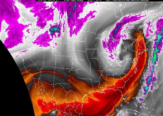
Weather Nerd Alert: "Dry Tongue". Large, full-latitude troughs of low pressure can pull dry, desert air into their circulations. These dry intrusions or "dry tongues" can cause rain (or snow) to cut off rapidly. The orange-shaded area above shows the dry air that quickly turned off the rain for New York, Philadelphia and Washington D.C., while "wrap-around" bands of moderate to heavy rain triggered flooding across the Great Lakes. More from UCAR
here.
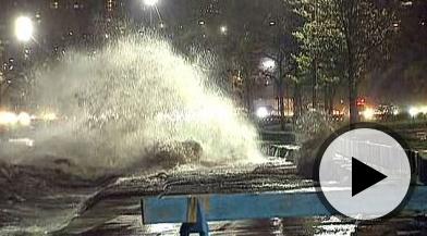
Massive Waves From Lake Michigan Flood Parts Of Chicago.
Fox News has more information on the storm that whipped up some 20-22 foot seas on Lake Michigan: "
Massive waves were expected to reach 24 feet early Thursday after high winds and rain caused Lake Michigan to flood parts of Chicago. Winds of more than 40 miles per hour caused water to batter areas near the lake Wednesday evening and prompted city authorities to discourage people from running, cycling or walking near the edge of lake, or swimming in it, myFOXchicago.com reported. The National Weather Service predicted waves would reach 18 feet Wednesday night and as high as 24 feet by 4:00am Thursday. Chicago's Lake Shore Drive bike path was also closed, the Chicago Sun-Times reported. The newspaper said some airlines were experiencing delays of at least 30 minutes at O'Hare International Airport while the weather conditions prompted Northwestern University to warn students to stay away from the shore at its lakeside Evanston campus."
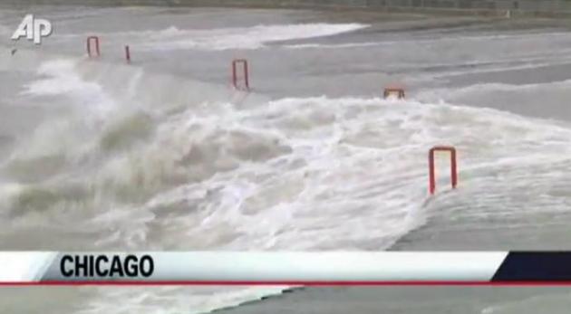
Wild Waves. Check out this
AP clip to see what 50 mph winds did to Lake Michigan.
"Land-Hurricane". Chicago's Amazing Wind And Waves. Jason Samenow from the Washington Post's
Capital Weather Gang summarizes the wild windstorm that temporarily shut down parts of Chicago: "
Sustained winds exceeded 40 mph in parts of Chicago for a time last night. And here are some of the peak wind gusts recorded (source Chicago Weather Center):
64 mph Chicago Harrison-Dever Crib
63 mph Michigan City Indiana
53 mph Chicago Soldier Field
Wave heights were predicted to reach as high as 20 to 25 feet overnight. The Chicago Weather Center reports waves on Lake Michigan reached 19 feet at 8 a.m. (7 a.m. CT) this morning 50 miles east southeast of Milwaukee."
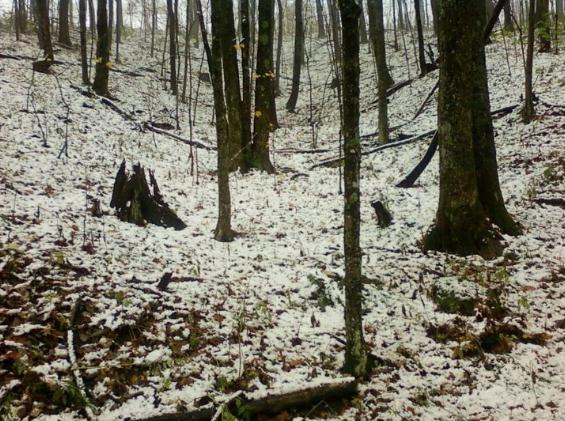
Kentucky Snow. A cool inch of slush fell on Black Mountain, in Harlan County, Kentucky.
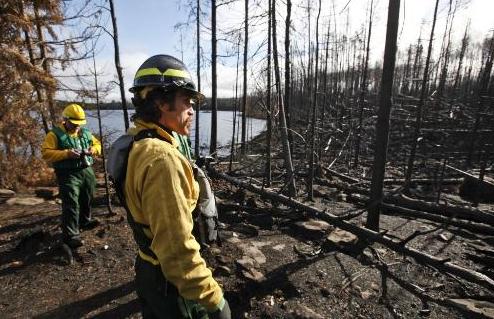
Signs Of New Life In BWCA Ashes. The
Star Tribune has a story about renewal taking place in the Boundary Waters, following the worst brushfire in nearly half a century: "
The biggest forest fire in Minnesota in half a century has left the most popular region of the Boundary Waters Canoe Area black and blue and green. Two months after lightning touched off a small blaze that later exploded into a 145-square-mile burn and a $21 million firefight, the route through Lakes One, Two and Three east of Ely is lined with stretches of blackened trees, uniform as teeth on a comb. But the view across any lake, even from charred campsites, is still dominated by the green forest that has inspired millions of canoeists for decades. U.S. Forest Service officials, who took members of the news media on a paddling tour through the area Wednesday, call the pattern a "mosaic" that, come spring, will be bursting with new greenery and wildlife, and a few new dangers. Already, some recovery is evident, with new, green grasses sprouting among charred, fallen logs. Wolf scat lay along a portage trail and freshly gnawed tree branches were piled atop a beaver lodge at the edge of a burned area. A bald eagle scouted for fish most of the morning from a treetop along Lake Three."
"Strongest Tornado I Can Recall In South Florida". Here are more details about the EF-2 tornado that struck the suburbs of Miami Tuesday night - winds estimated as high as 130 mph. Miami's
Sun-Sentinel newspaper has more information:
"Out of the night it roared, a tornado the likes of which the region had perhaps never before experienced, bearing hurricane-force winds of 130 mph that scarred a square mile of homes across two cities. "This is the strongest tornado that I can recall here in South Florida in quite a while," said Robert Molleda, warning coordination meteorologist for the National Weather Service in Miami. The storm Tuesday night left a swath of debris-strewn destruction over Sunrise and Plantation, striking some 74 homes, uprooting trees by Sawgrass Mills mall and leaving more than 1,000 residents without power for an hour."
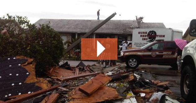 Homes Damaged As Tornado Hits Broward. NBCMiami
 has the details: "
Storm survey teams from the National Weather Service confirmed the touchdown of a tornado in West Broward Wednesday, a day after it ripped through and damaged several homes. Brad Diehl, an NWS meteorologist, confirmed it was a moderate tornado, a 2 on the Enhanced Fujita Tornado Damage Scale. The weather service said the tornado had maximum sustained winds of 120 miles per hour and the tornado was 125 yards wide and its path was 1.11 miles long. Residents in one Sunrise neighborhood woke up to debris-strewn lawns after the storm hit shortly after 10 p.m. in the area of Northwest 8th Street and 133rd Avenue, according to fire department officials. Officials said up to 50 homes were damaged or destroyed in the area, and residents said one house was knocked to the ground. Trees were uprooted, roofs ripped off homes and at least a couple people suffered minor injuries."
 Drought Update
. With a mild to moderate La Nina pattern forecast to linger into much of the winter, NOAA officials expect little or no improvement in drought condiitions gripping the southern Plains states. Dry weather has expanded northward across Missouri and Iowa into Minnesota, and I don't see any major storms capable of 1"+ soakings looking out 1-2 weeks. With any luck we'll see significant rain before the ground freezes up (mid/late November). Until then get out and give your shrubs and trees a good watering, especially newly planted trees and evergreens. Click here to see NOAA's Drought Monitor.
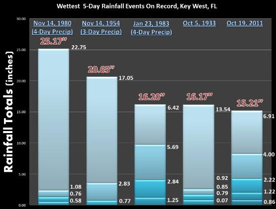
5th Wettest 5-Day Rainfall For Key West On Record. More details from the local NWS: “
Upon further review, the period from October 15th through October 19th of 2011 is the fifth wettest five day period in Key West. Rainfall records in Key West date back to 1871. Thanks to the Southeast Regional Climate Center for their assistance in reviewing the climate records for Key West. The Florida Keys have dried out since yesterday and no additional heavy rainfall is anticipated today into at least early next week.”
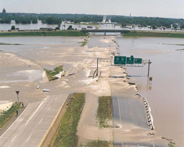
2011 Flood Offers Valuable Lessons. The
Yankton Daily Press & Dakotan has a look back at what has been learned from the historic levels of flooding on the Missouri River and its tributaries this year: "
VERMILLION — The U.S. Army Corps of Engineers is projecting that Missouri River levels next year will likely be about average to above average, and not exceed flood stages as they did last summer. However, Corps officials believed that would be the case earlier this year as they prepared to control water levels in the reservoirs behind the six mainstem dams that exist on the Missouri from South Dakota up to Montana as part of the Pick-Sloan plan. Water levels of the Missouri next year aren’t easy to predict, even when following the Corps’ Master Water Control Manual, which is tweaked every year to keep up with trends on the river. Cowman spoke Tuesday night before a small audience in the W. H. Over Museum in Vermillion to discuss the causes and impacts of this year’s flooding on the Missouri, and policy decisions that are being considered now that the flooding has “officially” ended. “According to what they (the Corps) are predicting in 2012, we will not get anywhere close to having to get into the exclusive flood control zone,” he said. “They’re basing that on predicted models for precipitation and snow pack, and they’re also basing that on what they plan on releasing over the winter and the upcoming spring." (photo courtesy of the USGS)
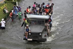 Flood Fears Loom Large For Bangkok
.
The Washington Post has the very latest on what is rapidly turning into Thailand's worst outbreak of flooding - now impacting the capital city of Bangkok: "
The threat has loomed large over this giant metropolis for weeks: Floodwaters could rapidly swamp glitzy downtown Bangkok, ruining treasured ancient palaces and chic boutiques on skyscraper-lined avenues in the heart of the Thai economy. The floods haven’t come, but the sense of imminent doom is growing by the day, seeping in through worried conversations, school closings and emptied store shelves. One measure of the fear: the protective walls of sandbags scattered across the city’s canals, homes and shop-fronts are expanding in number and height daily."
Computer Model To Predict Human Hurricane Response. When evacuation orders go out - will the public listen? What percentage will sit on their hands and try to ride out the storm (increasing the risk to first responders who may be called in to rescue these stragglers at the height of a hurricane).
Mysuncoast.com has an interesting story on using computers to model human behavior and hurricane responses: "
SARASOTA - Computer models regularly help show us whether a hurricane might be coming. Now, researchers want to develop a model that predicts how people will react when a storm threatens. This sort of mass psychology means more than academic exercise. Researchers at Purdue University say that if they can forecast how people respond to hurricane evacuation orders, it could make them more effective. While a computer model that predicts people's reactions to evacuation orders would be new, researchers have studied how humans respond to hurricane evacuation orders. “There's a couple of major predictors,” says Richard Reich, associate professor of psychology at USF Sarasota Manatee. “One predictor is previous evacuation experience.” He says emergency managers do not have to worry about issuing an order and hoping the storm actually strikes to justify the evacuation. The false alarm will not deter the truly concerned. “There's a myth out there that if people evacuate and nothing happens, then they're less likely to evacuate again,” says Reich."
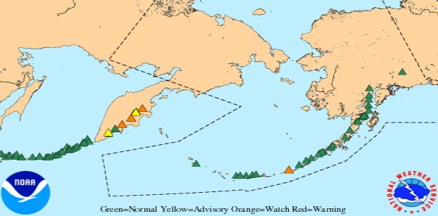
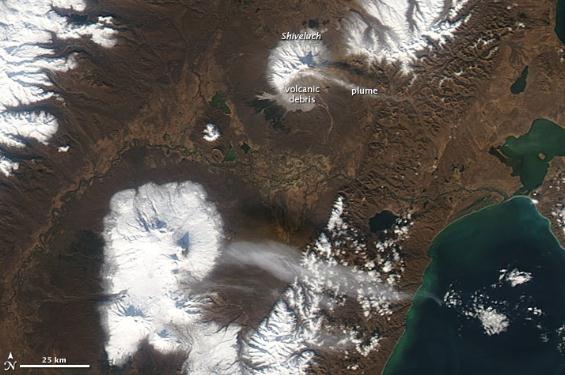
New Russian Volcanic Eruption. From NASA and the National Weather Service's
Volcanic Ash Advisory Center: “
This MODIS image, captured on October 16th, shows a plume of ash and gas being emitted by Shiveluch Volcano on the Kamchatka Peninsula in Russia. Shiveluch is one of Russia’s largest and most active volcanoes and is currently in “orange” or “watch” status – meaning there is an increased potential for an explosive eruption. Explosive eruptions of Russian volcanoes often send ash in the direction of the Bering Sea and the Aleutian Chain at altitudes frequently traveled by cargo and passenger aircraft. The NWS’s Alaska Aviation Weather Unit (AAWU) is also the Alaska Volcanic Ash Advisory Center (VAAC). Meteorologists at the AAWU and VAAC monitor volcanoes in both Alaska and Russia for eruptive activity and issue warnings for the aviation community to warn them of ash when it is a danger.”
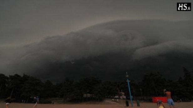
Wild Time Lapse. Check out the fast-moving
squall line approaching this coastal town (Croatia?). A free subscription to stumbleupon.com may be necessary to view this.
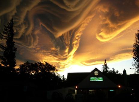 "Asperatus": Gathering Storm To Force New Cloud Name
. Thanks to the U.K. Guardian for passing on this incredibly eerie photo of "asperatus", a newly discovered genus of clouds: "
No new cloud type has been officially classified since 1951 but Gavin Pretor-Pinney who runs the Cloud Appreciation Society believes that there is a new cloud that deserves international recognition. He calls it asperatus, which means rough in Latin, and he is working with the Royal Meteorological Society to have it officially classified by the World Meteorological Organisation in Geneva."
 Climate Stories....
Climate Change Didn't "Go". It Was Pushed
Climate Stories....
Climate Change Didn't "Go". It Was Pushed.
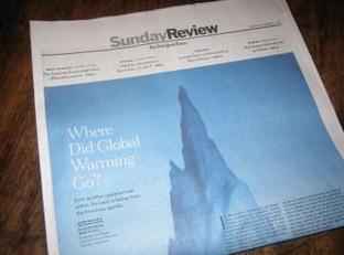
Grist.com takes on a recent New York Times article which asked "Where Did Global Warming Go? "
On the front page of The New York Times Sunday Review, Elisabeth Rosenthal has a nice bit of analysis that asks, "Where Did Global Warming Go?" It is, by the standards of mainstream U.S. media, an unusually direct and plainspoken description of America's current isolation when it comes to climate change.
The United States is the "one significant outlier" on responding to climate change, according to a recent global research report produced by HSBC, the London-based bank. John Ashton, Britain’s special representative for climate change, said in an interview that “in the U.K., in Europe, in most places I travel to” -- but not in the United States -- “the starting point for conversation is that this is real, there are clear and present dangers, so let’s get a move on and respond.” After watching the Republican candidates express skepticism about global warming in early September, former President Bill Clinton put it more bluntly, “I mean, it makes us -- we look like a joke, right?”
I think it's great that Rosenthal has done this. My beef, insofar as I have one, is that she doesn't push far enough in uncovering the causes of this state of affairs. She tiptoes up to identifying the main culprit, but never quite takes the leap."
 Breaking News: The Earth Still Goes Around The Sun, And It's Still Warming Up
. Here's an Op-Ed from climate scientist Peter Gleick at
Forbes.com: "
Oh, we already knew that. That’s what crossed my mind today when I read the news release and then the actual scientific papers and then the Wall Street Journal opinion piece about the new conclusions of the study of the Earth’s surface temperature records from the Berkeley Earth Surface Temperature (BEST) group. The scientific community has known — and been saying for decades — that the earth is warming up. Except for a small cadre of highly vocal, ideologically stuck, but increasing marginalized people, there is no dispute about this among scientists. The data are extensive – covering the globe – and they have been vetted, reanalyzed, corrected for error, compared with satellite data, and subjected to every known criticism. And independent group after independent group has found the same thing: the earth is warming. The fact that this is actually old news can be seen in the latest poll (from Stanford University with Ipsos and Reuters) that, despite the inability of all the leading Republican presidential candidates to publicly acknowledge this, even 83% of the American people believe the earth is warming. And there probably isn’t much that 83% of the American people will agree on these days. Indeed, even most remaining climate change skeptics and deniers have moved away from saying there is no warming. Now, their major talking points are that it isn’t caused by humans, or only a little bit, or it won’t be bad, or we can’t afford to fix it, or… Denial is a moving target."
Millions Will Be Trapped Amid Climate Change, Study Warns. This is an issue of morality - the poorest people on the planet are forecast to be disproportionately impacted by rising sea levels and drastic shifts in moisture and resulting desertification. The
New York Times has more: "
Millions of people are likely to become trapped in places that are extremely vulnerable to environmental change in the course of this century, according to a British government study released on Thursday. Prepared by the Foresight group, a think tank that advises the government on planning for the future, the report explores the complex relationship between human migration and changing environmental conditions and argues that the issue must become a top policy priority on national and international agendas. The study, titled “Migration and Global Environmental Change,” warns that trying to block migration will result in increased poverty and ultimately, potentially unmanageable waves of movement. It therefore recommends planning for and financially aiding some migration, both within and between countries. “Reduced options for migration, combined with incomes threatened by environmental change, mean that people are likely to migrate in illegal, irregular, unsafe, exploited or unplanned ways,” it warns."