 80 F
80 F. record high in Denver on Monday. Winter Storm Watch in effect for the Mile High City
(2-5" snow may fall Wednesday).
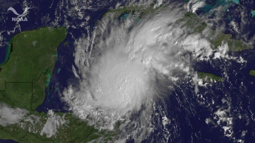 Hurricane Rina
 may threaten Cozumel and Cancun by the end of the week (some models hint that Rina may strengthen to Category 3 strength). A turn to the north, and then northeast is possible - Rina may pose some risk to Florida next week.
From 1950 through 2006, Alabama reported more F5 tornadoes than any other state. (source: SPC and
Birmingham Weather Examiner).
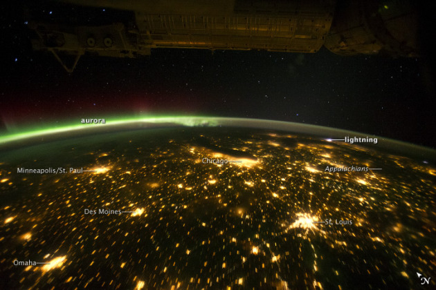
Incredible Sight. Check out this photo, snapped on September 29, posted by the
National Weather Service. You can see the city lights of the Twin Cities, Des Moines, St. Louis and Chicago, flashes of lightning over New England, and a spectacular Aurora Borealis visible on the northern horizon, a shimmering curtain of neon-green. Amazing.
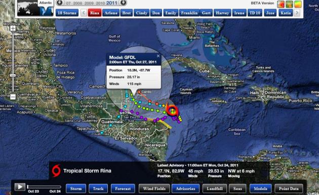
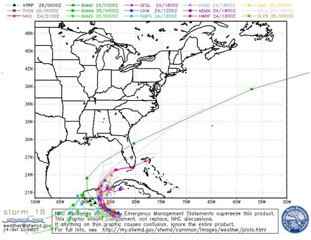
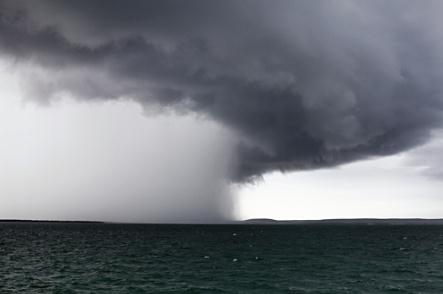
Hurricane Rina Track. All the models take Rina due west/northwest, some strengthening the hurricane to category 3 status (winds over 110 mph). The GFDL model has sustained winds near 115 by Thursday, October 27. Hurricane Rina may brush Belize or Honduras before heading north, dumping heavy rain and heavy surf on Cozumel and possibly Cancun before pushing into the southern Gulf of Mexico. From there a turn to the northeast is possible next week - south Florida may be impacted early next week.
Where Will Rina Go? Longer-range guidance from NHC suggests an eventual turn to the northeast - posing some threat to south Florida by next week. It's just too early to say with any confidence.
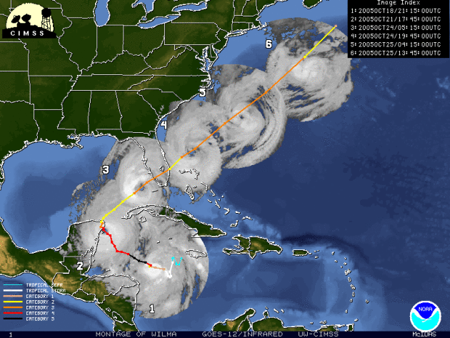 Track Similar To Wilma? Hurricane Wilma
 struck south Florida on October 24, 2005 (the busiest hurricane year on record in the USA). Wilma was a powerful Category 5 storm, in fact it was the strongest hurricane ever observed int he Atlantic basin. Rina is forecast to take a track eerily similar to Wilma. Time will tell.
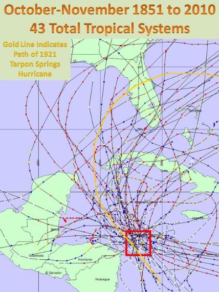
Hurricane Climatology. Here are the hurricane tracks since 1851 for systems located in the vicinity of Tropical Storm Rina. A drift to the north/northwest can't be ruled out - but the official forecast takes Rina more westerly, toward Honduras, by the end of the week. Rina may reach hurricane status before coming ashore late in the week.
* Rina: the 17th Storm Of The Season. 2011 has seen more tropical storms and hurricanes than any year but 2005 (that's the year we went entirely through the alphabet and started over again).
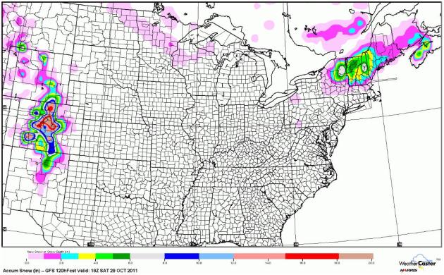
Snow Potential. The GFS model is hinting at some 12"+ amounts west of Denver (couple of inches downtown?) with a few inches for the Green and White Mountaints of northern New England.
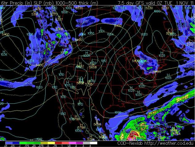
5-Day Precipitation. Uh oh - he's using the word "precipitation" rather than "rain". A sign of the times. A wave of low pressure rippling along an eastbound cool front will spark significant rain from Little Rock and Louisville to Pittsburgh, New York and Boston.
Halloween 2011. Here is the extended GFS outlook, valid 7 pm Monday evening. Showers are likely over the Pacific Northwest, Pennsylvania and New York State - otherwise most of the USA looks dry (and unusually mild across the Plains). We've seen worse...
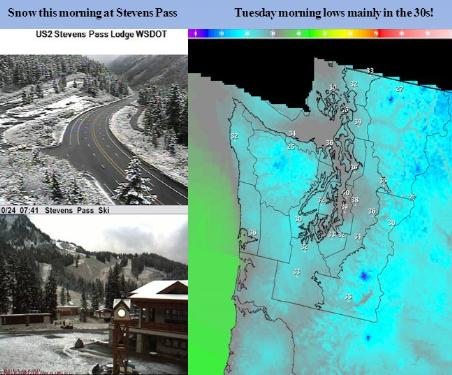
Seattle: Stevens Pass Snow. Here's more information from the Seatllte NWS: “
A trough passing down from the northwest today has ushered in a cooler air mass. Snow levels felll below 4000 feet this morning…with some light snow accumulations for Stevens Pass. Low temperatures will fall into the 30s tonight and again on Tuesday night. Many lowland locations will experience their lowest temperatures this Fall!”
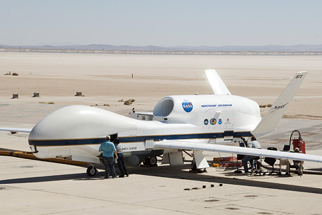
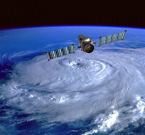
NASA Global Hawk Built By Northrup Grumman Prepares For 2012 Hurricane Missions.
Marketwatch has the story - very interesting how drone technology (perfected by the military) is now being tapped in other fields, including this attempt to make hurricane weather models more accurate and reliable by having more/better data from all levels of the atmosphere. Drones represent a much more cost-effective method for gathering raw data that ultimately gets fed into supercomputer solutions: "
Environmental scientists will utilize the Northrop Grumman built unmanned NASA Global Hawks as part of the multi-year Hurricane and Severe Storm Sentinel (HS3), a study of the processes that underlie hurricane formation and intensity change in the Atlantic Ocean. "The high-altitude and long-duration capabilities of NASA's Global Hawks allow HS3 to sample storms virtually anywhere in the Atlantic and for durations up to three times that of conventional aircraft," said principal investigator Scott Braun of NASA's Goddard Space Flight Center in Greenbelt, Md. "Being able to stay over a storm for 15 or more hours allows us to observe storms in ways that were simply not possible before." Environmental scientists came together to embark upon a multi-year airborne science investigation of hurricane formation and intensification - or HS3. The scientists prepared for their investigation at NASA Dryden Flight Research Center, Edwards Air Force Base, Calif. "Global Hawk's ability to fly as high as 65,000 feet for periods of up to 30 hours provides the science community the opportunity to explore remote areas of the Earth's atmosphere," said Scott Winship, advanced concepts vice president, Northrop Grumman Aerospace Systems. "Additionally, Global Hawk's flexible and mature design allows for modifying the aircraft with varying scientific instruments for different types of science missions." (photo above courtesy of NASA).
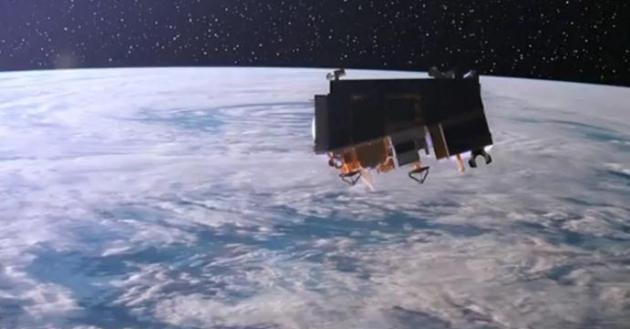
NPP: The Future Of Earth Observations. Here's a terrific
YouTube clip that explains the latest weather satellite to be launched later this week: "
The launch of a new polar-orbiting environmental satellite enables NOAA to continue issuing accurate forecasts and provide advance warning for severe weather, such as deadly tornado outbreaks, blistering heat waves, floods, snowfall and wildfires."
NOAA Improves Hurricane Forecast Technology. WMFE radio has an interview touching on new innovations and breakthroughs in hurricane forecasting for 2011-2012: "
Researchers with the National Oceanographic and Atmospheric Administration say they've gotten much better at predicting the path of a hurricane. They can now accurately predict where a hurricane will come ashore as much as 48 hours before landfall. But there's been very little progress in predicting the intensity of a storm. Shirley Murillo is a hurricane research meteorologist with the NOAA. Murillo said she has great hopes for the new Doppler radar scanners mounted on the tails of the P3 aircraft used in hurricane tracking. "It sort of provides a CAT scan of the storm.” Murillo said. “It gives us the wind structure which is important in how the storm is changing and evolving and therefore giving us a hint of the intensity of the storm."
Disasters Strain FEMA's Defenses. An update from
USA Today: "
Months before Tropical Storm Irene soaked Vermont in September, a spring storm flooded part of the state, washing out roads and bridges. The cost of the damage was relatively minor — $794,000, the Federal Emergency Management Agency found. On July 8, President Obama declared Vermont's situation a "major disaster." That entitled Vermont to millions of dollars in federal disaster aid at a time when FEMA was warning that its money for such aid was running out. Obama approved Vermont for disaster relief even though federal regulations set "a minimum $1 million threshold" in public damage for states seeking disaster funds."
New System Will Gauge And Track Storms. The
Seattle Times has the latest: "
Rain, snow and wind can't be stopped, but now they can be more accurately measured and predicted. The city of Seattle is using new technology that allows officials to know exactly how bad storms are and what neighborhoods are getting hit the worst. Seattle Mayor Mike McGinn is expected to unveil the storm-tracking technology Monday at the city's emergency-operations center, as part of the Take Winter by Storm campaign — a public-awareness effort to get Puget Sound-area residents ready for severe weather. The city's new system combines a range of weather data with computer programs that measure, calculate and predict snow, rain and winds across the metropolitan area. If conditions look ominous enough, city crews can be deployed before disaster strikes. They could, for instance, be ready to clear storm drains as a deluge begins. "There's a philosophy behind this, and it's that we can really help protect people and lessen economic damage," said Cliff Mass, a University of Washington meteorologist who helped design the system. SnowWatch (atmos.washington.edu/SNOWWATCH/), a first-of-its-kind forecasting tool, was launched last month while the RainWatch (atmos.washington.edu/SPU/) and WindWatch (atmos.washington.edu/SCL/) programs have been running in test mode for more than a year."
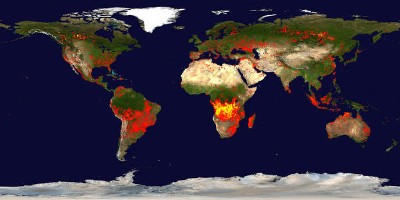
NASA Releases Satellite Data Visualizations Of Earthly Fires. Details from the
International Business Times: NASA has
released a series of new satellite data visualizations that show tens of millions of fires detected worldwide from space since 2002. The visualizations show fire observations made by the MODerate Resolution Imaging Spectroradiometer (MODIS) instruments onboard NASA's Terra and Aqua satellites. NASA maintains a comprehensive research program using satellites, aircraft, and ground resources to observe and analyze fires around the world. The research helps scientists understand how fire affects our environment on local, regional, and global scales. "What you see here is a very good representation of the satellite data scientists use to understand the global distribution of fires and to determine where and how fire distribution is responding to climate change and population growth," said Chris Justice of the University of Maryland at College Park, a scientist who leads NASA's effort to use MODIS data to study the world's fires."
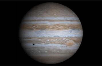
Bright Jupiter! Here's some timely information from
Sky and Telescope: “
Many of you may have noticed a very bright light in the eastern sky after sunset or in the western sky early in the morning before sunrise. This bright object is the planet Jupiter. Jupiter appears exceptionally bright right now because we are passing close, relatively speaking, to it as we pass by it in our orbit. Jupiter will be brightest on October 28th when it is at opposition, the point where it is opposite in the sky to the Sun. Here’s an article by Sky and Telescope magazine with more information about observing Jupiter."
More Jobs Predicted For Machines, Not People. This headline in the
New York Times caught my eye. The trick (now) is to find a job that can't be automated, computerized, or outsourced to China/India: "
A faltering economy explains much of the job shortage in America, but advancing technology has sharply magnified the effect, more so than is generally understood, according to two researchers at the Massachusetts Institute of Technology. The automation of more and more work once done by humans is the central theme of “Race Against the Machine,” an e-book to be published on Monday. “Many workers, in short, are losing the race against the machine,” the authors write. Erik Brynjolfsson, an economist and director of the M.I.T. Center for Digital Business, and Andrew P. McAfee, associate director and principal research scientist at the center, are two of the nation’s leading experts on technology and productivity. The tone of alarm in their book is a departure for the pair, whose previous research has focused mainly on the benefits of advancing technology." (photo credit
here).
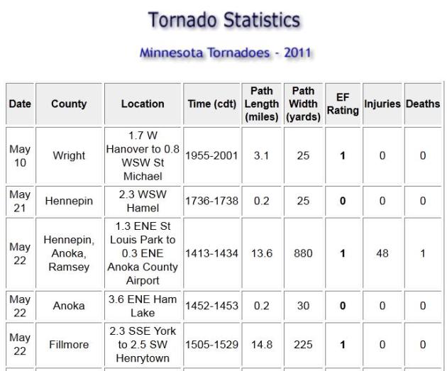
2011 Tornadoes In Minnesota. The Twin Cities office of the National Weather Service has the
details. A total of 31 tornadoes - the first one touched down on Wright County (near St. Michael) on May 10, the last one to skip across the state dropped down on Mille Lacs and Isanti Counties on July 30. Only 2 EF-2 tornadoes: Lincoln and Houston Counties. A far cry from 145 tornadoes in 2010. Thank God....
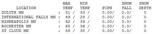
Last Lukewarm Day. Not bad at all for October 24: 58 at St. Cloud, 62 in the Twin Cities and 65 at Rochester, temperatures a good 5-10 degrees above average for much of Minnesota. Call me crazy, but I still don't think we've seen the last of the 60-degree days.
Tracking "Rina"
Harvey, Philippe, Rina and Whitney. Contestants on a new (forgettable) reality show on Bravo? Nope. These are some of the 2011 hurricane names. After World War II Navy pilots were able to name typhoons or hurricanes after girlfriends or wives. That led to naming hurricanes after women, which was very sexist (in 20/20 hindsight). Now NOAA rotates male/female, and Anglo, Hispanic and French names, reflecting every cultures impacted by these ocean-forming storms.
Hurricane Rina may brush Cancun with 100 mph+ winds by the end of the week, posing a risk to south Florida next week. Kind of puts today's cool front into stark perspective.
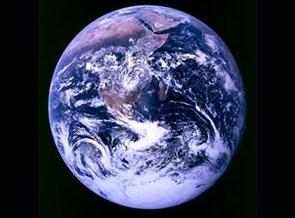
Climate Stories...
No Simultaneous Warming Of Hemispheres In 20,000 Years.
Planetsave.com has the details: "
One of the common arguments to dismiss those supporting the idea that the climate is warming as a result of manmade carbon dioxide emissions is that global warming is a natural thing; that it has always varied and that sometimes temperatures rise and that this is a perfectly natural occurrence. However in a new study it has been shown that a simultaneous warming of both the Southern and Northern Hemispheres has never happened in the past 20,000 years."
* TGdaily.com has another angle on the story
here:
"
He found that when the temperature rises in one hemisphere, it falls or remains unchanged in the other. "My study shows that, apart from the larger-scale developments, such as the general change into warm periods and ice ages, climate change has previously only produced similar effects on local or regional level," he says. During the last clear period of climate change - the Little Ice Age between 1600 and 1900 - Europe experienced some of its coldest centuries. However, says Björck, there's no evidence of corresponding simultaneous temperature changes and effects in the southern hemisphere."
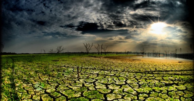
Crop Scientists Now Fret About Heat, Not Just Water. The story from
Reuters: "
But scientists now wonder if a more immediate issue is an unusual rise in day-time and, especially, night-time summer temperatures being seen in crop belts around the world. Interviews with crop researchers at American universities paint the same picture: high temperatures have already shrunken output of many crops and vegetables. "We don't grow tomatoes in the deep South in the summer. Pollination fails," said Ken Boote, a crop scientist with the University of Florida. The same goes for snap beans which can no longer be grown in Florida during the summer, he added. "As temperatures rise we are going to have trouble maintaining the yields of crops that we already have," said Gerald Nelson, an economist with the International Food Policy Research Institute (IFPRI) who is leading a global project initially funded by the Bill and Melinda Gates Foundation to identify new crop varieties adapted to climate change."When I go around the world, people are much less skeptical, much more concerned about climate change," said David Lobell, a Stanford University agricultural scientist. "