Beware! *A Leprechuan Warning for Monday*

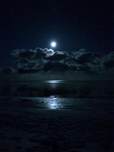
Full Worm Moon
Thanks to Aaron Weidner for the image below, who snapped this from Bluefin Bay on Saturday night as the Full Worm Moon was rising over Lake Superior! Nice picture!!
According to Space.com, the full worm moon gets it's name from:
"Mar. 16, 1:08 p.m. EDT: Full Worm Moon —In this month the ground softens and the earthworm casts reappear, inviting the return of the robins. The more northern tribes knew this as the Full Crow Moon, when the cawing of crows signals the end of winter , or the Full Crust Moon because the snow cover becomes crusted from thawing by day and freezing at night. TheFull Sap Moon, marking the time of tapping maple trees, is another variation."
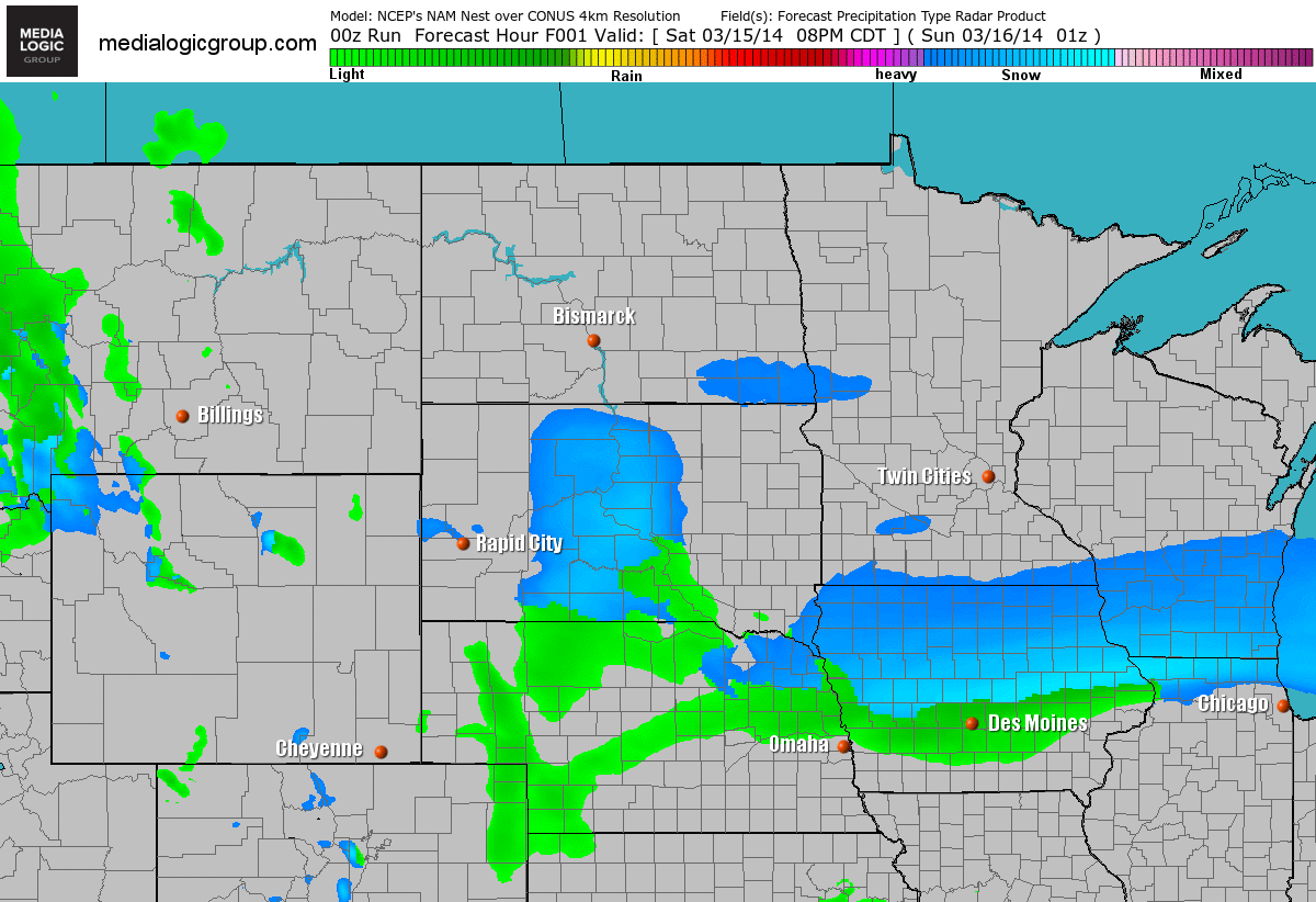
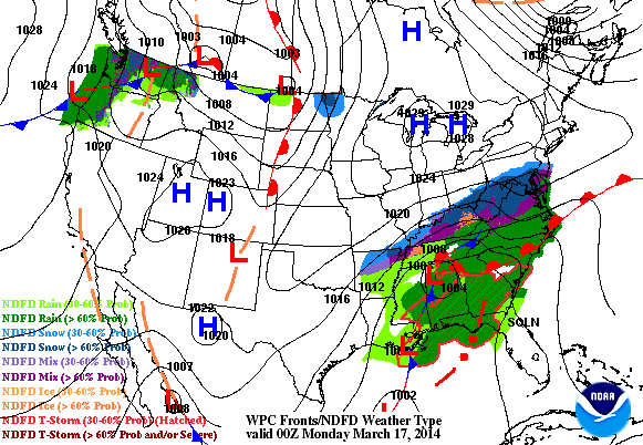
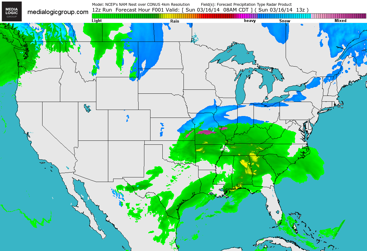
Future Radar
The future radar through Tuesday morning shows the storm system gathering strength. Because warmer air will be wrapping into the system, there will be a wide range of precipitation type. Rain, freezing rain, sleet and snow will all be possible as the system pushes through the Upper Mississippi Valley.
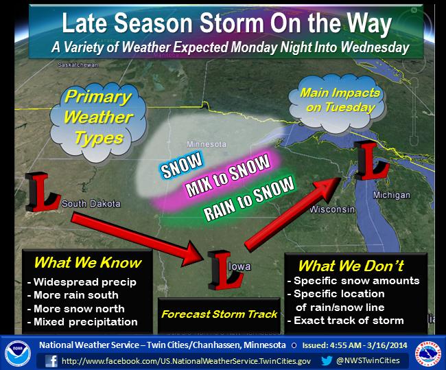
Storm Outlook
Here's a nice graphic from the National Weather service out of the Twin Cities showing the storms potential across the Upper Mississippi Valley through midweek. Note that the best chance for all snow looks to stay across the northern part of the state.
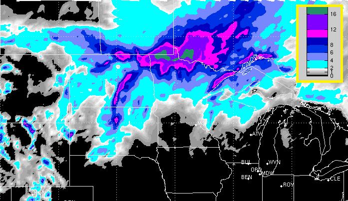
Snow Potential
Here was the snow potential through midday Wednesay, note that the heaviest accumulations look to stay across the far northern part of the state. Also note that the southern half of the state could see very minimal amounts due to the fact that warmer air will be wrapping into the system.
Today's Forecast: Weather
I found this gem on the Anchorman Facebook page... Enjoy!
Weather Outlook
2 fairly large areas of low pressure will be impacting parts of the country through the early/middle part of the week. The first of which will be situated across the Eastern Seaboard on Monday with heavy snow still ongoing across parts of the Mid-Atlantic Region. The second storm will be starting to take shape across the Upper Midwest/High Plains. By Tuesday, that northern storm will have bigger impacts on the Upper Mississippi Valley by Tuesday.
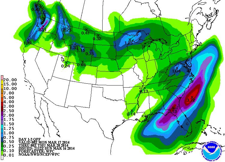
Precipitation Forecast
According to NOAA's HPC 3 day precipitation forecast, the heaviest moisture will be found in the southeastern part of the country. The maximum of nearly 2" to 3"+ will be aided by heavy rain and thunderstorms. The northern flank of the heavy precipitation band will be in the form of snow near the D.C. area. There is also a fairly decent swath of precipitation from the Pacific Northwest to the Upper Midwest. Some of this precipitation will also be in the for of heavy snow!
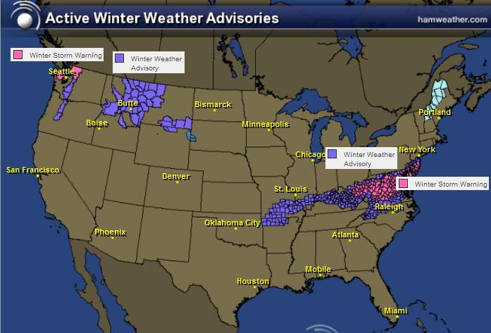
Winter Weather Headlines
The winter weather headlines with storm #1 will still be in place across the Mid-Atlantic Region through midday Monday. There is a chance of nearly 4" to 10" of snow through that time period. Also note the winter weather headlines that have been posted in the Northwest. That is from a secondary storm system that will eventually be responsible for several additional winter weather headlines across the Upper Midwest through midweek.
More Washington D.C. Snow
It has already been a cold and snowy winter, but there's more plowable snow expected through midday Monday in the D.C. area.
Here's the latest on the Winter Storm Warning from the National Weather Service out of Baltimore/Washington D.C.:
...WINTER STORM WARNING REMAINS IN EFFECT FROM 7 PM SUNDAYTO 2 PM EDT MONDAY...
* PRECIPITATION TYPE...SNOW
* ACCUMULATIONS...4 TO 8 INCHES.
* TIMING...A MIX OF RAIN AND SNOW EARLY THIS EVENING WILL CHANGE TO ALL SNOW BY MID EVENING. SNOW WILL CONTINUE OVERNIGHT THROUGH EARLY AFTERNOON MONDAY. THE HEAVIEST SNOW IS EXPECTED LATE THIS EVENING THROUGH EARLY MONDAY MORNING.
* TEMPERATURES...FALLING INTO THE LOWER 30S BY MID EVENING AND THEN DROPPING INTO THE LOWER TO MIDDLE 20S LATE TONIGHT. HIGHS MONDAY IN THE LOWER 30S.
* WINDS...NORTHEAST 10 TO 15 MPH WITH GUSTS UP TO 20 MPH.
* IMPACTS...ROADS WILL BECOME SNOW COVERED AND SLIPPERY. TRAVEL WILL BE DANGEROUS...ESPECIALLY TONIGHT THROUGH THE MORNING RUSH ON MONDAY.
================================================
Here are some great stats that have been compiled for the D.C. area by my good friend Jacob Wycoff from WeatherBug - Great stuff Jacob! Thanks!
First:
Average snowfall is 15.4”
2014 we’ve had 23.1”
Past seasonal snowfalls:
2011-12: 2.0”
2012-13: 3.1”
We haven’t seen 23” in one season since 2009-2010, when we got 56.1”.
Second:
We recently broke our 1,090 days long snow drought of no snowfalls over 2 inches on 21 January. Since then, we’ve 3 snowfalls over 2 inches. Nothing for nearly 3 years, then 3 within 2 months.
Third:
Average Temps:
Hi - 56°
Low – 38°
It hasn’t been an especially brutal winter like 2009-10, but it has been long and cold. The past three months, we’ve been below averages temperatures.
Jan: -3.8°
Feb: - 1.2°
Mar: -2.7°
Fourth:
Cherry Blossom festival starts on March 20th and runs through April 13th.
Peak bloom, defined as 70% are open, will be April 8-12, as forecast by the National Park Service. Snow is not expected to adversely affect the blossoms, nothing more than pushing peak bloom back a few days.
===============================
Here was the view from the Washington Monument from Sunday early evening prior to the snow moving in.
(Webcam courtesy: EarthCam)

Future Radar
Monday Severe Threat
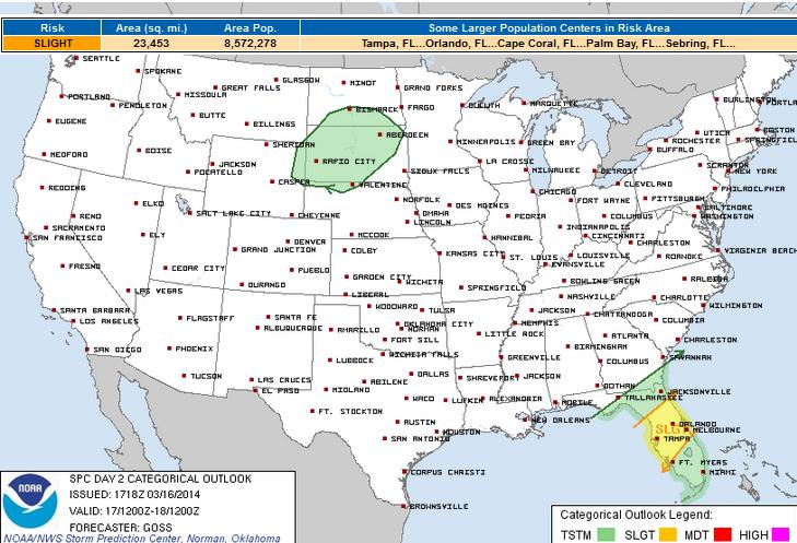
The best chance for any severe weather looks to be confined to places along and just east of the cold front Monday. This front will be placed in central Florida.
Here's the severe thunderstorm outlook from NOAA's SPC:
WIDESPREAD CONVECTION IS FORECAST TO BE ONGOING FROM THE SERN ATLANTIC COAST SWWD ACROSS NRN FL AND INTO THE GULF OF MEXICO...WITH SHOWERS AND THUNDERSTORMS EXPECTED TO STREAM CONTINUALLY NEWD ACROSS THIS SAME ZONE THROUGH THE DAY -- RESULTING IN PERSISTENT HEAVY RAINFALL ACROSS THE NRN FL VICINITY. ALONG AND AHEAD OF THE LEADING EDGE OF THE CONVECTIVE BAND...A MOIST BOUNDARY LAYER WILL AID MODEST DIURNAL DESTABILIZATION WHICH -- COMBINED WITH SUFFICIENT SHEAR SUPPORTED BY 50-PLUS KT MID-LEVEL WSWLY FLOW -- SUGGESTS SOME RISK FOR ISOLATED/DAMAGING GUSTS WITH A FEW STRONGER CONVECTIVE UPDRAFTS. SOMEWHAT GREATER SEVERE RISK MAY EVOLVE OVERNIGHT -- AS THE UPPER SYSTEM APPROACHES AND A GRADUALLY STRENGTHENING SURFACE LOW MOVES ACROSS THE PENINSULA. AS BACKGROUND ASCENT STRENGTHENS...A MORE LINEARLY ORGANIZED/VIGOROUS CONVECTIVE BAND MAY RESULT...YIELDING CONTINUED SEVERE RISK -- PRIMARILY IN THE FORM OF DAMAGING WINDS -- THROUGH THE END OF THE PERIOD.
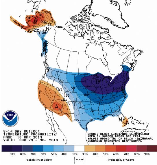
Temperature Outlook
Well, well, well... what's new. Not too surprising that according to NOAA's 8 to 14 day temperature outlook, the eastern two-thirds of the nation look to be much colder than average through the end of March. UGH!
Thanks for checking in and have a great week ahead! Don't forget to follow me on twitter @TNelsonWNTV