Deliriously Sloppy
You can only imagine the earful I've gotten this hyper-winter. I feel like an economist, standing in the wreckage of 1929's Great Depression. "It WILL get better!" Because it can't get any worse.
I
looked at the weather maps this morning and couldn't decide whether to
wake the neighbors or weep for joy. New colors are showing up: less
blues and purples, more yellow and orange. We're limping into spring,
and your faith in March may be partially restored in the week ahead as
steering winds aloft become zonal; blowing west to east. The Polar
Vortex gives way to a Pacific breeze.
Expect a thaw today - the
drive home will be a sloppy slush-fest, but who cares? The short-term
outlook calls for occasional showers of blue windshield washer fluid,
but I still don't see any Tournament Storms looking out at least a week.
Nearly
20 inches of snow on the ground will limit just how mild it can get in
the short term; ECMWF guidance hints at a few 40s early next week. Above
average? Unheard of. Nothing subzero looking out a week, just an Ice
Dam Advisory.
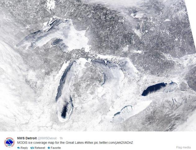
In today's weather blog: a rough winter for
Minnesota's white-tail deer & Lake Superior ice cover is approaching
95 percent, the all-time record set in 1979.
Yes, we've seen worse, but not lately.
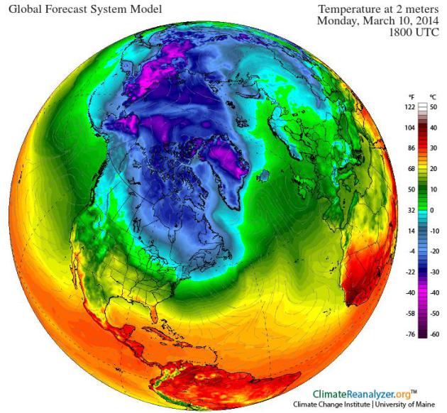
* GFS forecast temperatures midday Monday courtesy of Climate Reanalyzer at the University of Maine.
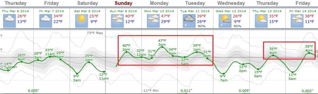
New Concept: Warmer Than Average.
After the 9th coldest meteorological winter on record in the Twin
Cities our collective expectations have been lowered. Suddenly freezing
is a big deal, 40s are an almost unimaginable meteorological treat.
ECMWF guidance is fairly consistent, trending even milder for the first
few days of next week; highs may reach 40F Sunday, climbing well into
the 40s Monday. 19" of snow will limit just how mild it can get anytime
soon, but the maps are, for lack of a better word, encouraging. Graphic:
Weatherspark.
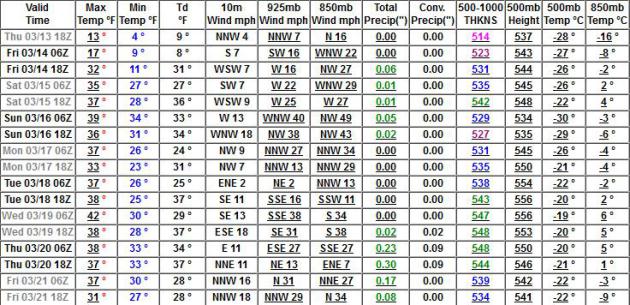
Subzero-Free.
Have we seen the last subzero lows of the winter season? I hope so, and
the latest GFS numbers lean in that direction. It will chill down late
next week, maybe a couple nights of single-digit lows, but we warm up
into the 30s and low 40s again the third week of March.
What's Wrong With This Winter?
Investment banker and prize rose grower Jack Falker in Edina takes a
look at the Polar Vortex and other weather oddities in his
latest blog post, reminding us that one (very cold) winter does not a trend make; here's an excerpt: "..
I
am also a great believer in statistical trend lines, and the extreme
minimum temperature (EMT) trend lines that I have plotted for almost all
Midwest cities, for the years since 1962, show that we are all on a
steady trend toward higher winter temperatures. The Twin Cities' EMT
trend line shows conclusively that we have moved into zone 5 and are on
our way to zone 6 in just a few years. One night of marginally zone 4
temperatures in 2014 certainly does not change the upward slope of our
trend line in a meaningful way, so it is statistically reasonable to
assume that we will continue to see warmer EMT's in the year's ahead..."
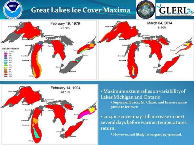
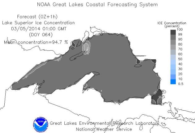
Lake Superior Approaching The Record Of 95% Ice-Covered. At last report,
NOAA showed ice cover of 94.7% - very close to the all-time record set in 1979.
NBC News has the story; here's an excerpt: "..
The
ice cover may even eclipse the 1979 record of 95 percent with
temperatures expected to dip in the coming days after “one polar vortex
after another,” Jia Wang, a research ice climatologist for the Great
Lakes Environmental Research Laboratory in Ann Arbor, told NBC News. “In
the next week or two, the forecast is that the temperatures will be
under freezing.The lake still has about 10 days to grow in ice cover — 5
percent is no problem,” he said..."
* Time Magazine has a time-lapse of Lake Superior freezing up
here.
Tracking The Ice. According to the
Great Lakes Environmental Research Laboratory this year's ice cover probably will not exceed the previous record of 94.76% set in 1979.
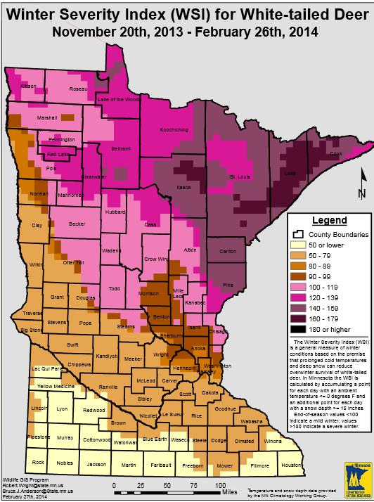
Winter Severity Index For White-Tailed Deer.
We aren't the only ones feeling the effects of a pioneer winter. The
persistent cold is impacting Minnesota's white-tailed deer population,
as tracked by the
Minnesota DNR: "
The
Winter Severity Index (WSI) is a general measure of winter conditions
based on the premise that prolonged cold temperatures and deep snow can
reduce overwinter survial of white-tailed deer. In Minnesota the WSI is
calculated by accumulating a point for each day with an ambient
temperature of 0F and an additional point for each day with a snow depth
greater than 15". End of season values less than 100 indicate a mild
winter. Values greater than 180 indicate a severe winter."
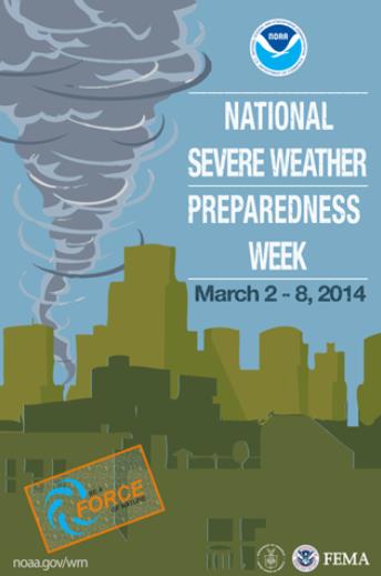
Be A Force Of Nature: National Severe Weather Preparedness Week.
I know it seems odd to be talking severe thunderstorms and tornadoes
with a semi-permanent glacier in your yard, but the first severe
thunderstorms of 2014 are probably no more than 3 or 4 weeks away. Here
are some links to resources and timely reminders, courtesy of
NOAA: "
In 2013, there were seven weather and climate disaster events with
losses exceeding $1 billion each across the United States. These events
included five severe weather and tornado events, a major flood event,
and the western drought/heat wave. Overall, these events killed 109
people and had significant economic effects on the areas impacted.
During National Severe Weather Preparedness Week, March 2-8, 2014, NOAA and FEMA
will highlight the importance of preparing for severe weather before it
strikes. Being prepared for severe weather doesn’t have to be
complicated or expensive. A few simple steps, such as having a disaster supplies kit, could help save your life. During National Severe Weather Preparedness Week, we ask that you Be a Force of Nature by knowing your risk, taking action and being an example where you live..."
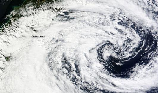
Storm Brings 100-Year Flood To Christchurch, New Zealand.
ImaGeo at Discover Magazine has the story; here's the introduction: "
The
satellite image above shows the powerful storm that brought gale force
winds and 36 hours of heavy rainfall to New Zealand, triggering what has
been described as a 100-year flood in the city of Christchurch. The city has been beset by flooding before, as well as a devastating magnitude 6.3 earthquake in 2011 that killed 185 people..."
Image credit above: "
NASA’s
Terra satellite captured this image of a powerful storm swirling off
the coast of New Zealand on March 4. The storm has caused what has been
reported as a 100-year flood in the city of Christchurch." (Source: NASA).
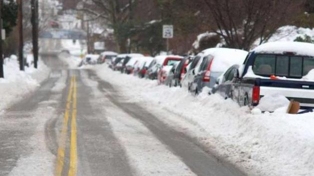
Why Snowstorms Are More Devastating Now To American Cities.
An inch of snow in the 60s? No big deal. Our parents called this
"flurries". Today an inch of snow falling at the wrong time and wrong
temperature can bring a city's transporation grid to a halt. What has
changed? Here's an excerpt of an interesting story at
NBC Philadelphia: "
Snowstorms
have become devastating to American cities -- thanks to a commonplace
technology: the private automobile. "The evil snow is upon us.” So wrote
New York lawyer and diarist George Templeton Strong in December 1879,
describing a storm that had paralyzed the city. Teams of horses pulled
ploughs through the snow, piled high along the sidewalks; downed
electrical lines pitched the streets into darkness. In the future,
Strong imagined, things would be better. “A century hence cities will be
put under glass,” he predicted, “and New York will be enclosed in a
huge crystal palace...”
Photo credit above: "
Slippery West Sedgwick Street in Northwest Philadelphia afer a recent storm." Bas Slabbers - NewsWorks.org.
Ice-Covered Lakes May Be Bottling Arctic Cold For Spring.
Chicago has had a very memorable winter: 3rd coldest meteorological
winter with 74" snow, more than 43" above average, to date. They've
experienced 2 winters in the Windy City! Here's a recent video and
excerpt from
The Chicago Tribune: "
With
March just days away, Chicagoans can’t be blamed for looking forward to
the disappearance of the polar vortex. But be warned: with the Great
Lakes more ice-covered than they have been in decades, the latest blast
of arctic chill is being bottled for spring. The early descent of this
season’s chill forced the Coast Guard to start its ice-breaking ships
sooner than any time in recent memory and raises the prospect that all
that frozen water will slow any hint of a spring warmup..."
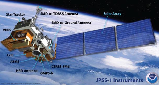
Storm-Tracking NOAA Satellite System Gets A Technology Boost.
CNET
describes how these new Earth platforms may improve storm predictions
by providing higher-resolution data streams into the models we use on a
daily basis; here's a clip: "
A three-satellite storm-tracking system
run by the U.S. government is getting some updates that will support a
complete technological refresh. Raytheon said today that it has booked
$185 million in new business for the Joint Polar Satellite System's
Common Ground System. The JPSS, a collaborative system between the
National Oceanic and Atmospheric Administration and NASA, is a
polar-orbiting environmental system designed to both track storms and
other weather events and take and send back to Earth imagery showing
changes in the planet's environment over time..."
Image credit above: "
One of the three Joint Polar Satellite Systems satellites.
" (Credit: NOAA/NASA).
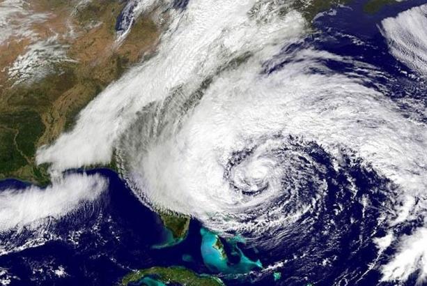
New Hurricane Model Can More Accurately Predict Hurricane Path, Intensity. redOrbit has an interesting story - here's the introduction: "...
In
addition to incorporating real-time Doppler radar information, the
convection-permitting hurricane analysis and forecasting system
(WRF-EnKF) also uses high-resolution cloud-permitting grids, which allow
for the consideration of individual clouds in modeling a storm system.
"Our model predicted storm paths with 100 km - 50 mile - accuracy four
to five days ahead of landfall for Hurricane Sandy," Zhang said. "We
also had accurate predictions of Sandy's intensity..."
Image credit above: "
Superstorm Sandy as it slams the Northeast in October 2012." Credit: NOAA/NASA.
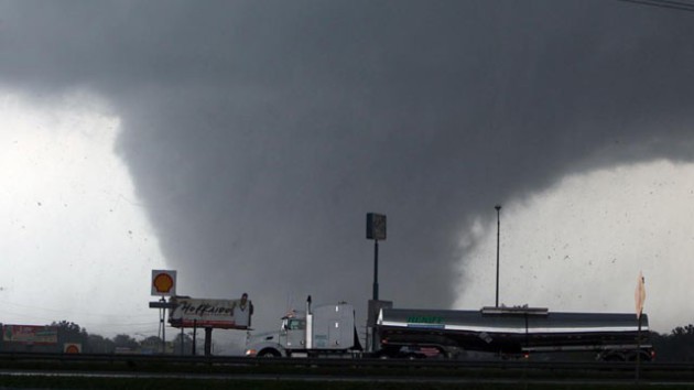
Oklahoma Congressman's Proposal Would Extend Lead Time For Tornado Warnings.
A 45-60 minute lead time for tornadoes? It's not as far-fetched as it
sounds. But it brings up an interesting dilemma: can you provide too
warning? If I have an hour's notice I might be tempted to run home, or
pick up the kids at school - instead of heading to the basement. Here's
an excerpt from
Insurance Journal: "
An
Oklahoma congressman has proposed legislation that would make the
protection of people and property a priority for federal weather
forecasters and extend the lead time for tornado warnings. Oklahoma
Insurance Commissioner John D. Doak has expressed his support for the
Weather Forecasting Improvement Act (H.R. 2413), sponsored by
Congressman Jim Bridenstine (R-Oklahoma), which would establish the
Tornado Warning Extension Program. The resolution is aimed at funding a
research program within the National Oceanic and Atmospheric
Administration (NOAA) to extend the lead time for tornado warnings
beyond one hour..."
When
Hurricane Sandy slammed into southern New Jersey in October 2012, it had essentially confounded both the
NOAA‘s Global Forecast System (GFS) and the European Centre for Medium-Range Weather Forecasts (ECMWF).
Now,
a new real-time hurricane analysis system being developed at Penn State
University has been shown to accurately predict the track and intensity
of the deadly storm.
“For this particular study aircraft-based
Doppler radar information was ingested into the system,” said
Fuqing Zhang,
a professor of meteorology at Penn State. “Our predictions were
comparable to or better than those made by operational global models.”
Read more at http://www.redorbit.com/news/science/1113081033/hurricane-model-accurately-predict-storm-path-intensity-022614/#ezvDvxMucTOvdtR6.99Oklahoma Congressman's Proposal Would Extend Lead Time For Tornado Warnings.
A 45-60 minute lead time for tornadoes? It's not as far-fetched as it
sounds. But it brings up an interesting dilemma: can you provide too
warning? If I have an hour's notice I might be tempted to run home, or
pick up the kids at school - instead of heading to the basement. Here's
an excerpt from
Insurance Journal: "
An
Oklahoma congressman has proposed legislation that would make the
protection of people and property a priority for federal weather
forecasters and extend the lead time for tornado warnings. Oklahoma
Insurance Commissioner John D. Doak has expressed his support for the
Weather Forecasting Improvement Act (H.R. 2413), sponsored by
Congressman Jim Bridenstine (R-Oklahoma), which would establish the
Tornado Warning Extension Program. The resolution is aimed at funding a
research program within the National Oceanic and Atmospheric
Administration (NOAA) to extend the lead time for tornado warnings
beyond one hour..."
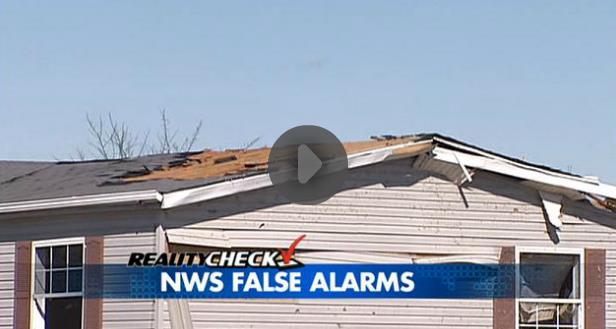
Reality Check: The Tornado "False Alarm" Problem.
The last I checked 70% of tornado warnings were false alarms,
nationwide. It's always better to err on the side of safety, caution and
protecting human life, but too many false alarms and the public can be
apathetic. "They're crying wolf again - just ignore the sirens". Here's a
video clip and excerpt from a story at
fox19.com: "
It
has been a crazy winter, filled with snow and bitter cold. Mother
nature trumped the winter weather on Thursday with the first severe
weather episode of 2014. The National Weather Service issued five
tornado alerts. Only three weak funnels appeared -three out of five with
a false alarm rate of 40 percent. Why does the Tornado Warning policy
treat weak, spin-up funnels the same as it does monstrous killer
tornadoes? The policy is set at high levels in the National Weather
Service bureaucracy. The system needs to be fixed..."
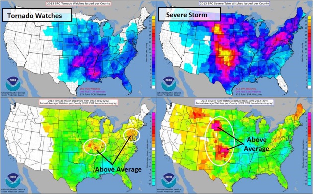
Tornado And Severe Storm Watches Issued In 2013.
Last year was relatively quiet, especially for tornadoes, with a few
notable exceptions (around Oklahoma City). The upper left graphic shows
the total number of tornado watches, the lower left depicts departure
from the 20 year averages - showing a slight increase in tornado watches
over the Middle Mississippi Valley and Mid Atlantic. The column on the
right shows total number of severe storm watches (upper left), and
departure from average, with a more significant spike in severe storm
watches for the Plains. Source:
NOAA SPC.
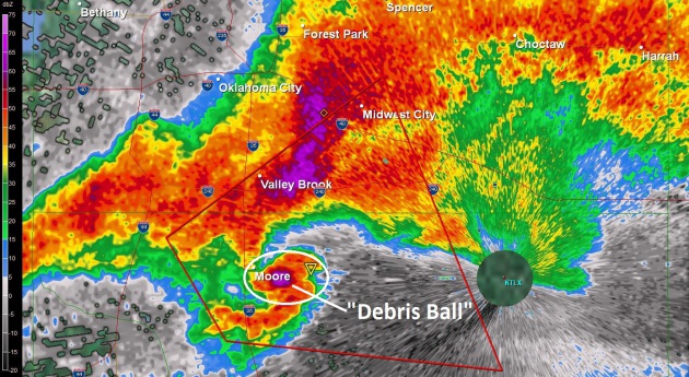
The Future Of Severe Weather Forecasting. Here's a video and excerpt from News 9 Chief Meteorologist David Payne in Oklahoma City on
NewsOn6.com: "...
He
said he's never seen so many intense tornadoes in such a short period
of time as we saw in May 2013. He adds we took something good from the
outbreak, new data models that will help us better predict future
storms. "These are models that can actually model individual storms and
they're going to come up with an ensemble of forecasts of varying
initial conditions," Bluestein said. "You may be able to assign, a
better probability that yes, the next day there will be storms. Of those
storms, there will be a certain chain that there will be tornadoes..."
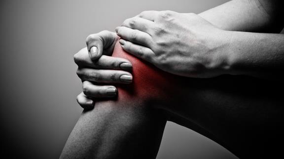
Your Joints, Pain And The Weather.
All those things your grandmother taught you are true. Our bodies are
(mostly) water - why wouldn't we respond to pain sparked by continuous
fluctuations in atmospheric pressure, temperature and moisture? Here's a
clip from an article at
Grandparents.com. What, you don't troll this site? "...
Several medical studies—although not all—back up these suspicions. As early as the 1960s, a University of Pennsylvania physician put
people with arthritis into a weather chamber and found that falling
barometric pressure and increased humidity increased the perception of
pain. In 2007, Tufts researchers studied 200 people with knee arthritis and found that both barometric pressure and cold affected pain. In January of 2014, Dutch researchers
found that in people with severe hip arthritis, barometric pressure and
humidity had a modest effect on pain perception. (Weather can have
other painful effects, too: There’s evidence that lightning can trigger migraine headaches, for example.)..."
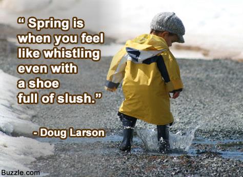
9 Things You Should Know About Your Caffeine Habit.
Yeah, I'm hooked, along with most people I know. In my 20s I trained
for a climb up the Matterhorn in Switzerland and tried to kick coffee
altogether (to help reduce the risk of altitude sickness). I was
miserable for a week and then the headaches went away. Not sure I want
to go through that again. Here's a clip from a story at
Huffington Post: "...
What's
the verdict? Is it good or is it bad? If I had a simple answer, it
would have been a five-page book. It can be more effective than I had
any idea, in terms of improving your alertness, your cognition, your
athletic ability. It can have stronger more acute effects on sleep and
anxiety than I'd imagined. It can be terrific. I think it's important
that everybody recognize how much is good for them, what it does for
them when they take it, what they feel like when they don't take it, and
experiment..."
* graphic above courtesy of
buzzle.com.
Read more here: http://www.kansas.com/2014/03/03/3321809/researcher-finds-possible-clue.html#storylink
Climate Stories....
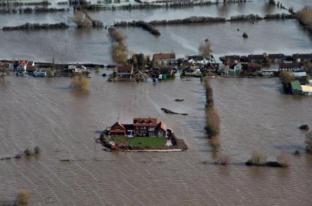
British Floods Could Be A Harbinger. Britain just experienced its wettest winter since accurate records were started in the 1800s, and a sentence in this article at
The New York Times
did a good job (in my humble opinion) of explaining the implications of
climate change and climate volatility. No, it doesn't mean we'll all be
warmer (all the time), but it increases the potential for unusual
events that manifest themselves via freakish weather. We're already
seeing that, worldwide. Here's an excerpt: "...
Yet Somerset may
be a microcosm for the dilemmas that Britain and other countries are
likely to face in the future as sea levels rise and climate change
accentuates unusual weather. As in other places around the world,
people in Britain have chosen to live near water, where damaging floods
may occur and are likely to become more frequent. “You often hear people
saying, ‘You shouldn’t build on flood plains,’ but many cities are on
flood plains,” said Roger A. Falconer, a professor of water management
at Cardiff University in Wales, not far from the Levels. “Where do you
draw the line?...”
Photo credit above: " Flood
waters inundate the area as one house stands alone and dry near the
flooded village of Moorland in Somerset, southwest England, Thursday
Feb. 13, 2014. The house is owned by Sam Notaro, who has built his own
levee to hold back the flood waters, as the local communities face
further misery in the coming days with heavy rain, wind and snow
predicted to sweep across Britain." (AP Photo/Steve Parsons, PA).
Energy CEO: Climate Change Is Real, Driven By Humans. I almost fell off the Doppler after reading this story at
fuelfix.com; here's an excerpt: "
BHP
Billiton CEO Andrew Mackenzie, who leads the world’s largest mining
company, said Tuesday that climate change is real and driven by human
activity. Speaking to energy industry leaders at the CERAWeek conference
in Houston, Mackenzie, a geologist by training, said evidence of the
climate trend is clear and compelling. “You can’t argue with a rock,”
Mackenzie said, noting geological signs of the change. Mackenzie — whose
Australia-based company produces oil, gas, coal and uranium — also
advocated for the creation of a carbon pricing system that would enable
the market “to identify the most cost-effective methods of cutting
emissions...”
Photo credit above: "
BHP Billiton CEO Andrew Mackenzie speaks at the IHS CERAWeek energy conference in Houston on March 4, 2014." (Mayra Beltran/Houston Chronicle).
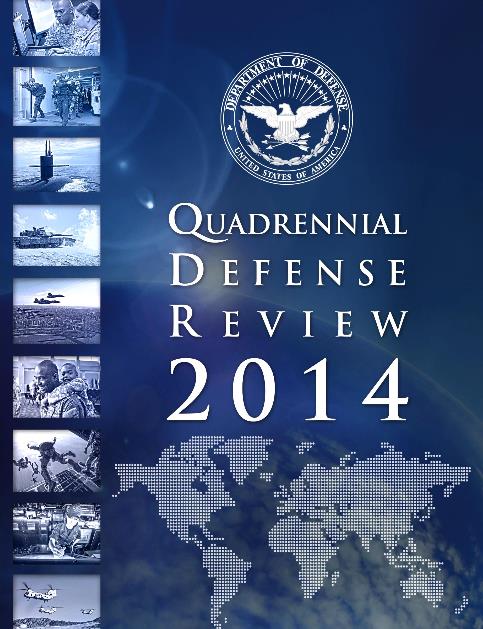
The Defense Department Takes Climate Change Seriously.
The Navy is concerned about projecting power in a rapidly melting
Arctic, and implications of higher sea levels on their major ports of
Norfolk and San Diego. The 88 page PDF of The Department of Defense
Quadrennial Defense Review 2014 is
here. Navy Admiral David Titley (retired) writes: "
For
all the defense policy geeks ... DoD released today the 2014
Quadrennial Defense Review -- climate change and its impacts to national
security highlighted throughout. About as good as it gets from a high
level policy document."
* more details on the implications of rising seas and increased climate volatility on the military at
The Center for Climate & Security.
Climate Study: Rising Seas Could Wipe Out Many Cultural Landmarks.
LiveScience has the story - here's a clip: "...
Sea-level
rise has been a key concern for climate scientists, but making precise
projections of how much, and how fast, sea levels may rise remains
tricky. As water heats up, it expands and takes up more space, which
causes sea levels to rise. Furthermore, rising surface temperatures
trigger melting ice, particularly in the sprawling ice sheets that cover Greenland
and Antarctica. It is difficult to make accurate predictions of how
much sea levels may rise, but Marzeion said it is generally thought that
for every 5.4 degrees F of warming, sea levels could rise nearly 23
feet (7 meters)..."
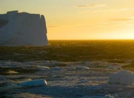
Global Warming Slows Down Antarctica's Coldest Currents.
Scientific American has the article - here's the introduction: "
A
shift from briny to fresh in Antarctica's ocean waters in recent
decades could explain the shutdown of the Southern Ocean's coldest,
deepest currents, a new study finds. The cold currents, called the
Antarctic Bottom Water, are chilly, salty rivers that flow from the
underwater edge of the Antarctic
continent north toward the equator, keeping to the bottom of the
seafloor. The currents carry oxygen, carbon and nutrients down to the
deepest parts of the ocean. Previous studies have found this deep, dense water is disappearing, though researchers aren't sure if the shrinkage is part of a long-term trend linked to global warming, or a natural cycle..."
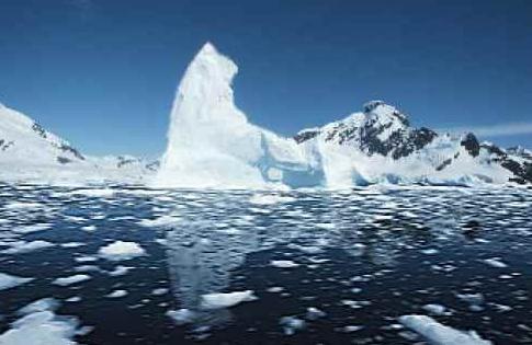
Photo credit: "
Icebergs and sea ice floating atop near-freezing surface waters of the Weddell Sea." Courtesy of Eric Galbraith.
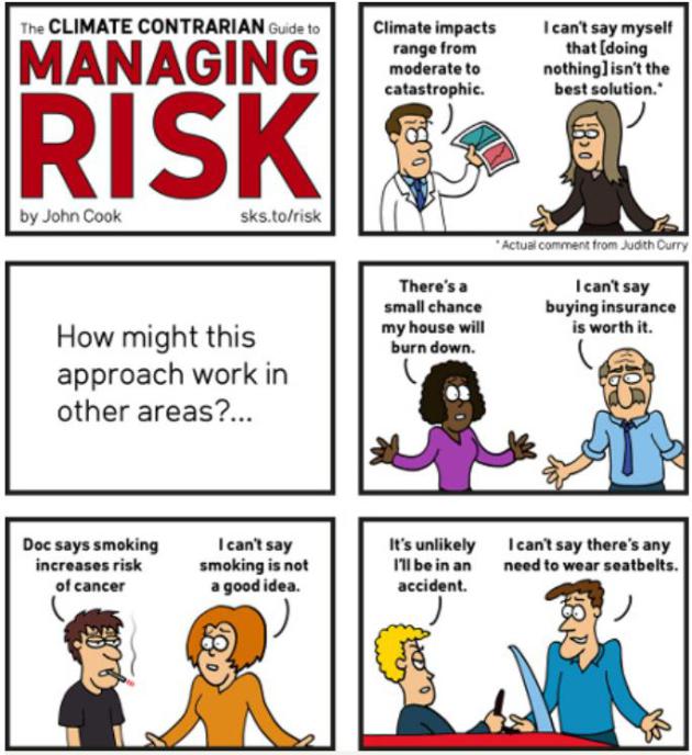
Cartoon: The Climate Contrarian Guide To Managing Risk.
Maybe if we ignore it - it'll go away? If we managed the rest of our
lives the way some want to "manage" climate change and increased weather
volatility, we'd be accused of taking leave of our senses. Here's an
excerpt from
The Guardian: "...
When it comes to managing risk, uncertainty is not our friend.
Uncertainty means it's possible the outcome will be better than we
expect, but it's also possible it will be much worse than we expect. In
fact, continuing with business-as-usual would only be a reasonable
option in the absolute best case scenario. Doing nothing is betting the
farm on a very low probability scenario. It's an incredibly high-risk
path that fails to reduce the threats posed by the worst case or even
most likely case scenarios..."
Cartoon credit above: "
The climate contrarian guide to managing risk." Created by John Cook.
