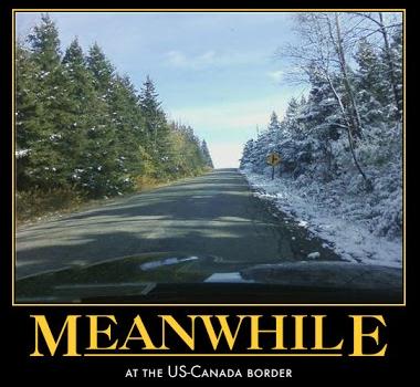
Slow Motion Spring
Why
is 40F a chilly annoyance in October but a wondrous revelation in
March? Weather Relativity. It's why the first flurries of fall generate a
ripple of excitement. By April the mere mention o snow generates veiled
threats and growling howls of protest. And that's from family
members.
We have a right to be grumpy. By any objective measure it
was the toughest winter since the late 70s. In a slowly warming world
we get stuck with a Pioneer Winter. It doesn't seem fair.
MSP has
picked up 58.4 inches so far this winter; 13 inches more than average -
16 inches on the ground - about 3-5 inches of liquid water trapped in
the snow in your yard. According to NOAA the spring flood threat is at
or below the historical average west of the Mississippi River. But
heavier snow pack northeast of the Twin Cities means a higher risk of
flooding in the St. Croix, Chippewa and Eau Claire basins. It all
depends on how fast we warm, and whether heavy rain accelerates snow
melt.
I suspect we'll limp into spring this year; 90-day trends
show a nagging cool bias into May. A few hours of wet snow Tuesday may
give way to a more impressive storm one week from tomorrow.
For now the Doppler is holding at Defcon 5.
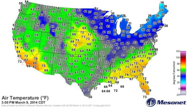
Sunday Afternoon Temperatures.
Minnesotans were happy to see 40s; imagine how residents of Nebraska
must have felt, basking in 70s. Click here to see current USA
temperatures, courtesy of
mesonet.org.
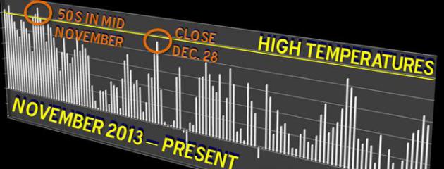
Flirting With 50F?
There's still a little too much snow on the ground for 50-degree highs
in the Twin Cities. The last time we enjoyed 50s was mid November,
according to the
Twin Cities National Weather Service.
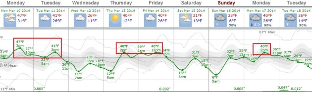
Looks Like March.
ECMWF "European" guidance shows highs well up into the 40s today, then
cooling off a bit midweek before mellowing again late in the week. There
are growing signs of a cold smack by the middle of next week, but it
doesn't look polar/subzero. A higher sun angle means the risk of subzero
temperatures drop off rapidly as we head into mid-March. Graphic:
Weatherspark.
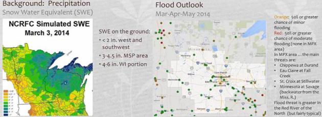
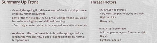
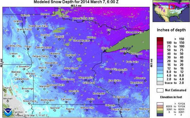
Flood Potential.
The risk of river flooding is less west of the Mississippi River, but
greater north and east of the Twin Cities, because there's more snow on
the ground, and more liquid water locked up in the snow. For a video
briefing of flood potential from the Twin Cities National Weather
Service
click here.
Major Take-Aways.
I grabbed these images from the Twin Cities NWS video briefing, but
here are the main bullet points. The major thing to remember: flood
potential will hinge on the rate of warming, any heavy rain events in
March and April, even humidity levels.
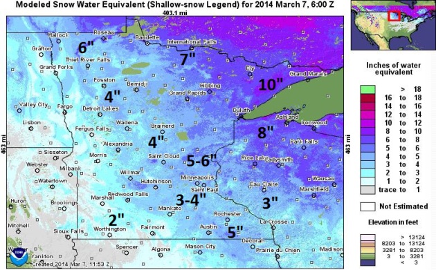
Snow Water Equivalent.
The latest numbers from NOAA estimate 3-4" of liquid water trapped in
the snow pack over the south metro, but closer to 5-6" from Isanti and
Cambridge to Taylors Falls, as much as 10" along Lake Superior's North
Shore. Pray for a gradual thaw (with no heavy rain).
Unusually Deep Snow Over Northeastern Minnesota.
In his most recent post, Dr. Mark Seeley answers a listener question
about the deep snow pack along the North Shore and over the Minnesota
Arrowhead. Here's an excerpt of his response at
Minnesota WeatherTalk: "...
Though
not record-setting it is rare to have snow depths over 40 inches, yet
several observers have reported these amounts for this winter including
47 inches near Two Harbors, 43 inches at Isabella, 42 inches at Wolf
Ridge and Babbitt, 41 inches at Cook, and 40 inches at Cloquet and Grand
Marais. The measurement of 47 inches neat Two Harbors is the deepest
snow there since they measured 51 inches in March of 1965. Similarly at
Babbitt the reading of 42 inches is the most there since a snow depth of
52 inches in February of 1969. The state record by the way is a snow
depth of 75 inches at Pigeon River Bridge in March of 1950..."
Alerts Broadcaster Briefing: Issued Sunday night, March 9, 2014.
*
Another Significant snowstorm is brewing for midweek: Wednesday looks
like the roughest day for travel and facility impacts from the Ohio
Valley into New England.
* Evolution of model runs suggesting a
plowable snowfall for Chicago (probably 4-6"), with the heaviest snow
bands passing south/east of The Windy City. The heaviest amounts are
likely from near Toledo and Cleveland into northern Pennsylvania,
upstate New York and much of New England Wednesday night into Thursday
morning.
Boston may wind up with 8-12" snow by Thursday.
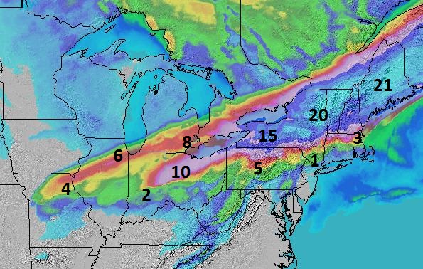
Model Trends.
The maps above show NOAA's snowfall prediction (upper left) and the
proprietary Alerts Broadcaster model (upper right), suggesting less snow
Chicago and portions of the Ohio Valley, but heavier amounts from
Cleveland into interior New England Wednesday and Wednesday night.
Early Snowfall Estimates.
The storm is still 48-72 hours away, and any slight variation in the
track will impact the final numbers, but the trends our (in-house)
models were showing are showing up in the very latest model run, showing
significant (plowable) snows for the Ohio Valley, but much heavier
amounts east of Cleveland, with nearly a foot of snow possible from
northern Pennsylvania and much of New York State into New England. With
the atmosphere cold enough for all snow I expect 8-12" for metro Boston
by midday Thursday.
* New York City will see rain at the height of
the storm Wednesday PM hours, ending as a few inches of slushy snow
late Wednesday night and Thursday morning. Travel will be impacted for
the Thursday AM commute in the Tri-State Region.
* Detroit may be close to the northern edge of the heaviest snow band; latest models suggest 4-6" in the Motor City Wednesday.
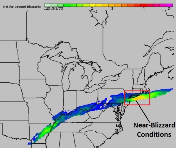
BPI Summary.
The proprietary Alerts Broadcaster BPI, or Blizzard Potential Index,
shows a possibility of near-blizzard conditions (sustained winds and low
visibility) from near South Bend and Terre Haute to Toledo and
Cleveland, with intensification near the coast sparking another area of
very heavy snow from near Boston to Portland by late Wednesday night and
Thursday morning. Timing the storm:
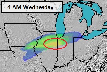
Wednesday Complications In Chicago.
Although I expect the heaviest snow bands to set up south/aest of
Chicago, I do expect delays and cancellations at ORD and MDW Wednesday,
with latest models suggesting 3-6" for the Chicagoland area. Closer to
South Bend and Terre Haute closer to 8-9" may fall Wednesday.
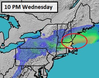
Fast-Moving System.
By 10 PM Wednesday night Boston may be experiencing blizzard or
near-blizzard conditions, with low visibility and high winds an issue
into the morning hours Thursday.
Summary: It's
still early, but enough ingredients are converging for a very
significant snowfall from the Ohio Valley into portions of the Great
Lakes and New England. A plowable snow is likely in Chicago, Detroit,
Indianapolis, South Bend, Toledo and Cleveland, with as much as 8-12"
from east of Cleveland into Buffalo, Syracuse and Rochester by the PM
hours Wednesday, spreading rapidly into the rest of New England
Wednesday night and Thursday morning. Latest models suggest 8-12" of
snow for metro Boston, most of that falling Wednesday evening into
midday Thursday, enough to shut down the city for 12-18 hours, if the
models are on the right track (and I suspect they are).
Another
update Monday as we receive more data and weigh the various model
solutions. It's been the roughest winter since the late 70s and early
80s for many northern cities, and Old Man Winter isn't quite done with
us yet. The pattern remains active and volatile. Stay tuned for more
details as the specifics on this storm crystallize.
Paul Douglas - Senior Meteorologist - Alerts Broadcaster
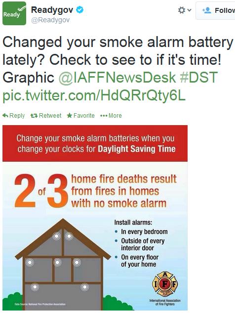
Have You Checked The Batteries In Your Smoke Alarm? Switching to Daylight Saving Time is a good time to take stock of the smoke detectors in your home. According to
ready.gov 2 out of 3 home fire deaths are the result of fires in homes with no smoke alarms.

The Future Of TV Is Coming Into Focus, And Looks Pretty Great.
Will every show you care about eventually be delivered online, and
on-demand? What will this do to traditional network TV schedules? Are we
heading to more of a Netflix model for most of our entertainment?
Quartz has a thought-provoking article; here's the introduction: "
The future of TV is here. It’s just not evenly distributed. If
it doesn’t seem like the American television industry is in the middle
of a dramatic transformation, that’s simply because the pieces are
scattered all over the place. But they are starting to come together. One transformative piece arrived earlier this week, when Dish Network secured the rights to
include ABC, ESPN, and other popular channels owned by Disney in a TV
service delivered entirely over the internet. Negotiating deals like
that one has generally been the biggest impediment to internet TV in the
United States..."
Photo credit above: "
It's all controlled by this guy." Reuters/Joe Skipper.
Climate Stories....
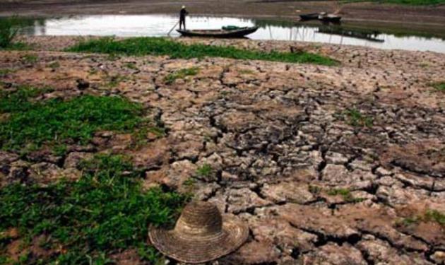
Global Warming Will Intensify Drought, New Study Says. Here's more on Kevin Trenberth's latest paper, a good overview from
The Guardian - here's a clip: "...
A very recent study by Trenberth et al., "Global warming and changes in drought"
published in Natural Climate Change has investigated the way droughts
are measured. They discuss various drought metrics such as the
Standardized Precipitation Index which is based entirely on
precipitation, the Standardized Precipitation and Evapotranspiration
Index which includes ET effects, and the Palmer Drought Severity Index
(PDSI) which balances precipitation, evaporation, runoff, and includes
local soil moisture and vegetation. This most sophisticated metric has
led different teams of researchers to very different conclusions about
drought trends..."
Photo credit above: "
A new study finds that global warming will probably cause droughts to set in quicker and be more intense." Photograph: David Gray/REUTERS.
* more on the ongoing debate over extreme drought and climate change from
Tamino.
Out There: Climate Change Is For Real. Here's an excerpt from an Op-Ed at
The Poughkeepsie Journal: "...
The
report also states that concerns about major tipping points —
illustrated fantastically in the 2004 Hollywood film “The Day After
Tomorrow” — are unfounded. No, you won’t need a dogsled to get to the
New York Public Library. Nor is the Gulf Stream likely to stop flowing
anytime soon. But even here, the report says, we are entering new
climate realities and as a result, the uncertainty “is large.” The
bottom line? The body of evidence about climate change continues to
grow. Many questions still need to be answered. And more research is
imperative. Believing otherwise is akin to being an insect that believes
windshields don’t exist."
 Who Cares About Flowers Anyway?
 Here's a clip from an Op-Ed at
The Boston Globe that got my attention: "...
Flowers
stink. They’re expensive and can’t hold a charge. And for the life of
me, I can’t remember the last operating system update. No music. No
video. No apps. No, technology is what we find beautiful today.
Understated design, clean lines, and functionality have become our
preferred aesthetic. Never mind that nature provided us this template to
begin with. Being plugged in is what we value. We have no time for
sentimentality. Perhaps that’s why we’ve so easily turned our backs on
the spot-on warnings of scientists for decades now that our current use
of energy, the juice that powers our beautiful products, means the
climate will get too hot for plants to survive..." (Photo courtesy of Tricia Frostad).
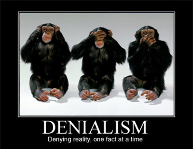
Cultural Production Of Ignorance Provides Rich Field For Study.
This report focuses primarily on smoking and the willingness for
corporate interests to keep doubt and confusion going (if it's good for
business), but tell me if this excerpt from
The Los Angeles Times has a familiar ring: "...
But
then there's ignorance custom-designed to manipulate the public. "The
myth of the 'information society' is that we're drowning in knowledge,"
he says. "But it's easier to propagate ignorance." That's especially so
when issues are so complicated that it's easier to present them as the
topics for discussion in which both sides are granted equal time...."
Elizabeth Kolbert: "The Whole World Is Becoming A Kind Of Zoo." Here's the intro to an interview and book review at
The Guardian: "
Elizabeth Kolbert is the author of The Sixth Extinction,
which argues that a catastrophe that may be as significant as the one
that wiped out the dinosaurs is under way around us. But whereas the
previous five mass extinctions were caused by natural phenomena, Kolbert
shows us that this one is manmade. One third of all reef-building
corals, a third of all freshwater molluscs, a third of sharks and rays, a
quarter of all mammals, a fifth of all reptiles, and a sixth of all
birds, says Kolbert, "are heading towards oblivion..."
Climate Change Is A Conservative Cause - Really. Here's an excerpt of an Op-Ed from former South Carolina (Republican) Congressman Bob Inglis at
The Miami Herald: "...
Usually,
we conservatives feel dragged along by the ever-expanding liberal ship
of state. We see ourselves as the anchor on that ship, and in many ways
we are. But on this issue of climate change, we have the opportunity to
be the ship’s engine. We passionately believe in markets and free
enterprise. We want to avoid regulatory dictates on climate change. And
we want to eliminate all subsidies for all fuels. What some of us
haven’t considered is the possibility that the biggest subsidy of all is
being able to pump pollutants into the air with no accountability.
Those pollutants are fouling our families’ lungs and endangering the
climate for those who will come after us. We can improve our lives and
theirs by simply changing what we tax. Cut taxes on income. Put a tax on
pollution..." (Image: Wikipedia).
Amen.
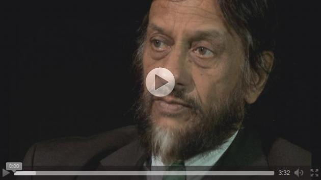
Floods And Gales Are Taste Of Things To Come, Says UN Climate Science Chief.
The Guardian
has the video interview - here's the introduction to the story: "The
heaviest rainfall in 200 years, floods and gales experienced in Britain
this winter are a foretaste of what is certain to occur in a warming
world, the head of the UN's climate science panel has told the Guardian.
"Each of the last three decades has been warmer than the last. Extreme
events are on the increase. Even if what we have just had [this winter]
was not caused by anthropogenic climate change, events of this nature
are increasing both in intensity and frequency," said
Rajendra Pachauri, chair of the Intergovernmental Panel on Climate Change..."
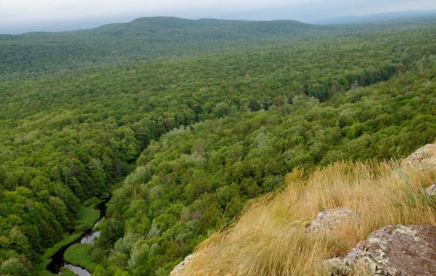
"Energy Sprawl". Is A Shrinking Wilderness The Hidden Cost Of Energy Security? LiveScience has an interesting perspective - here's an excerpt: "...
Our
study predicts the potential for development of up to 106,004 new gas
wells and 10,798 new wind turbines, affecting roughly 1,224,053 acres of
forest land and resulting in the creation of up to 1,490,732 acres of
impervious surfaces due to development of roads, well-pads and pipelines
— materials such as concrete or soils compacted by development are
highly impervious, meaning fluids cannot pass through them. As it turns
out, this is enough impervious surface to cover an area larger than the
state of Delaware..." (Photo credit: Jesse Lewis).
Climate Science Resources. If you're looking for more information about climate science, impacts and predictions
here is a good place to start, with links to (scientifically credible) sources.