GFS vs. ECMWF
Meteorologists
are an odd bunch. When we're right (it has been known to happen) we
puff out our chests, noting our experience and good sense. When we're
wrong we blame the weather models. "It's not my fault, the computers
made me do it!"
In 1976 there was 1 weather model (LFM). Now there
are dozens. Lately the Europeans have been focusing all their time
& money on 1 model, the ECWMF, which has done a better job on many
(but not all) days. The "Euro" gave me an 8-day heads-up that Superstorm
Sandy might hook into the northeast in 2012.
But don't bet
against the USA. Dan Luna, at the local NOAA office, told me "our NOAA
NCEP Computer, the one running the weather models, will have its
computing power increased from 208 Teraflops to 1900 Teraflops...very
soon the GFS will be upgraded to 13KM out to 10 days. That will be a
game changer!"
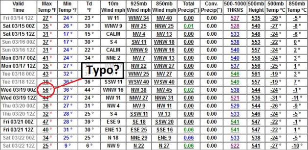
The weather models we study continue to predict a
glorious rerun of Pacific air; 3 days at or above 40F next week? In
Minnesota we call this a warm front.
No major storms are brewing,
but NOAA has issued an El Nino Watch for late 2014. The last major El
Nino was 1998, which turned into the warmest year on record, worldwide.
Details below.
* as of February 25, Cliff Mass reports that
NOAA's new supercomputer hasn't even been ordered, while the European
Center (ECMWF) has just secured a new (American) supercomputer to try
and push the envelope even further. His must-read post is
here.
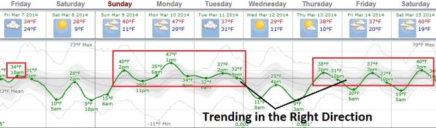
Looks More Like March.
After a very cold start, we're finally seeing evidence of slow
moderation in the coming weeks, when 30s should be the norm, with a few
days above 40F. Pacific air may lure the mercury well into the 40s
Monday before cooling down again around midweek. Nothing subzero in
sight for MSP at this point. Graphic: Weatherspark.
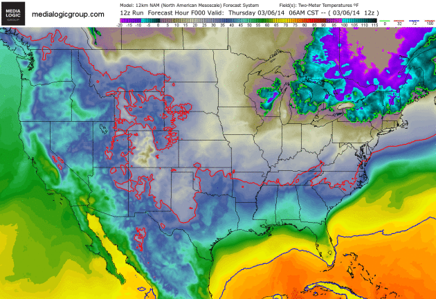
Minor Weekend Relapse, Then Welcome Temperature Inflation Next Week.
I hesitate calling this a warm front (unless you live on the central
Plains, where 60s are possible by early next week). For the rest of us: a
not-as-cold-front is shaping up, as steering winds aloft become more
westerly, more zonal, treating many ice-encrusted northern cities to a
welcome spurt of 40s. 2-meter NAM temperatures courtesy of NOAA and Ham
Weather.
Huh?
I almost dialed 911 after calling up the latest GFS numbers. No, I
don't believe it - we have to get rid of more snow before 50s become a
reality, but it was a welcome, heartwarming sight nonetheless; more
hints of what's to come.
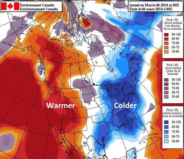
NAEFS Extended Outlook. Here is the temperature anomaly outlook for March 14-21, courtesy of
Environment Canada. The pattern is shifting, but painfully slow.
4th Coldest Meteorological Winter, Statewide. Here are a few highlights from the latest HydroClim Update from
The Minnesota DNR:
- February
precipitation totals were well above historical averages in eastern
Minnesota counties, near to below-average in western Minnesota locales.
Record February monthly snowfall totals of 24 to 36 inches were reported
in many northeast Minnesota communities.
- Average monthly
temperatures for February in Minnesota were well below historical
averages, finishing 10 to 12 degrees below normal.
- The statewide average temperature for the meteorological winter (December through February) ranked fourth coldest of the 119-year modern climate record.
- Except
for a few west central Minnesota counties, current snow depths are well
above the historical median for the date at all locations.
- There
is a near-normal risk for moderate or higher level spring flooding
along the Red River, Minnesota River, and Upper Mississippi River. There
is a somewhat elevated risk for moderate or higher level spring
flooding in the St. Croix River basin.
* Moderate risk of river flooding on the Red River. Details from
inforum.com.
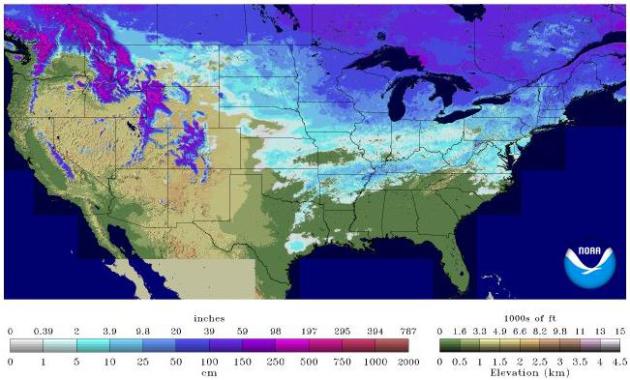
USA Snowcover In Early March: Third Highest Level On Record. Only 1969 and 1978 saw more snow on the ground in early March, from coast to coast. Here's an excerpt from a story at
USA Today: "
As
of Tuesday, North America is covered by the third-highest amount of
snow this late in the season since records began in 1966, according to
NOAA's U.S. National Ice Center. Only 1969 and 1978 had more snow cover
at this point in the year, according to Sean Helfrich of NOAA's National
Ice Center..."
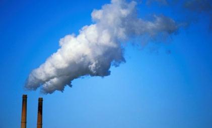
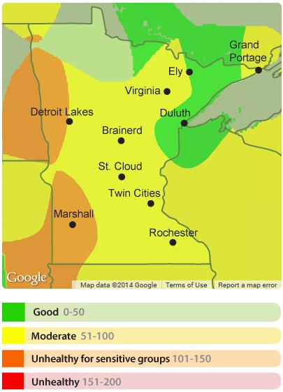
Air Pollution Advisory Western Minnesota.
The Minnesota Pollution Control Agency has issued an advisory for poor
air quality over much of western and southwestern Minnesota through
midday today.
Details here.
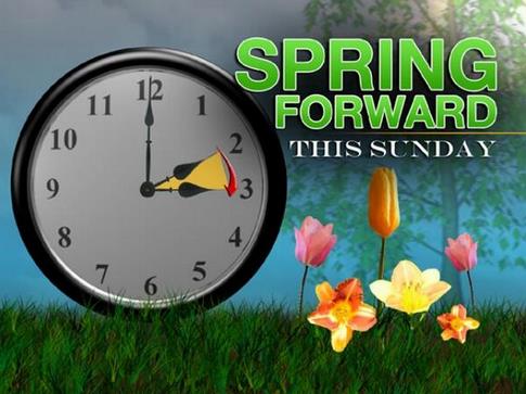
Spring Forward.
Yes, we lose an hour of sleep Saturday night, but here's another
encouraging sign of lukewarm days to come. Don't forget to turn your
clocks ahead 1 hour before you turn in Saturday night.
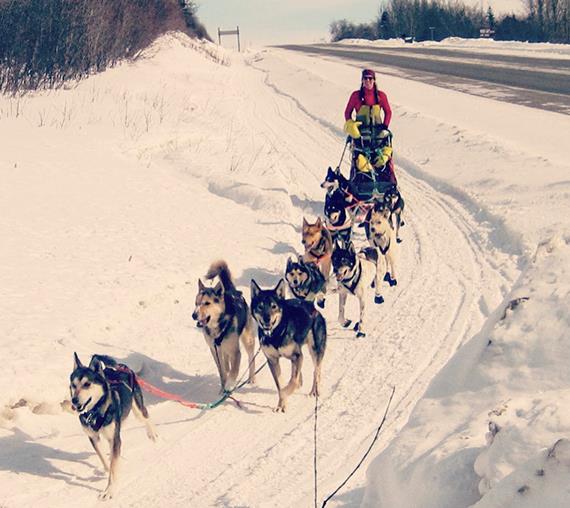
Something's Missing. Yes, snow, at least in Alaska, where the Iditarod is underway.
Monica Zappa
(a St. Cloud State University graduate participating in the grueling
race, featured in the photo above) reports unusual amounts of ice vs.
snow on the course; many lakes and streams are slushy and unstable. Eric
Holthaus has a good recap of the springlike conditions at Slate; here's
an excerpt: "
The dogs are ready, the gear is in place, and mushers
are gathering for this weekend’s start of Alaska’s classic sled dog
race, the Iditarod. There’s just one thing missing: snow. After one of
the warmest Januaries in Alaska’s meteorological record books, parts of the epic thousand-mile sled dog route were bare ground and open water
as recently as last week—not exactly the winter wonderland that’s more
typical this time of the year in what is usually one of the coldest
parts of North America..."
*
Here are the latest Iditarod standings - at least report Monica was 48th.
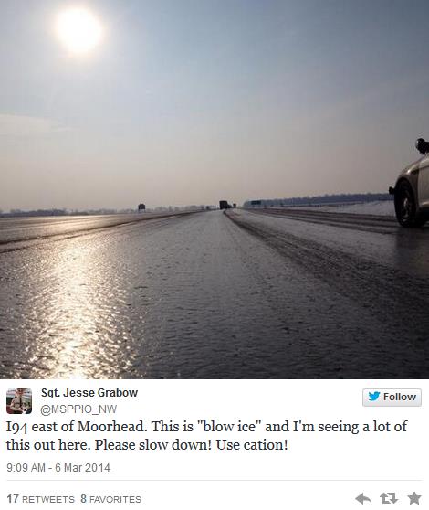
What The Heck Is "Blow Ice"?
It's not trending like "Polar Vortex" but a new phrase has been coined
to describe an age-old problem. Details at Rick Kupchella's
BringMeTheNews.com: "...
So, after “polar vortex,” “umbles,” and “bombogenesis,” add “blow ice” to your winter-weather vocabulary.
Grabow tweeted BringMeTheNews that blow ice is the result of wind
blowing snow across the road and either slightly warmer temperatures or
tires melt it, but the moisture is still cold enough to freeze and
quickly become ice..."
Who knew?
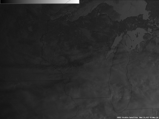
Great Lakes Ice. Check out the
CIMSS high resolution visible satellite
image from Thursday morning, courtesy of the University of Wisconsin.
What caught my eye was the ice calving off the eastern regions of Lake
Michigan, water currents pushing the ice flows south and west - an
amazing sight.
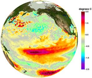
Scientists: El Nino (May Be) A-Comin'.
There are markers in the Pacific that suggest some of that warm water
that's been accumulating over time may slosh east later in 2014. There's
only one problem: NOAA is flying blind to some extent; about 40% of
ocean buoys that monitor wind, swells and water temperatures are
operational right now. Here's an excerpt from
Mashable: "...
Michael
McPhaden, a senior scientist with NOAA's Pacific Marine Environmental
Laboratory in Seattle, told Mashable that some similarities exist
between the ocean and atmospheric state right now compared to
observations shortly before the onset of the 1997-1998 El Niño event.
This suggests that if an El Niño does occur, it could be an unusually
strong one..."
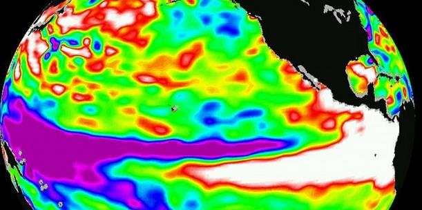
Image credit above: "
Sea surface
height anomalies across the Pacific Ocean on December 1, 1997. The warm
water associated with El Nino raises sea surface heights. Measurements
taken by the U.S. and French TOPEX/Poseidon satellite." Image: NASA/JPL.
El Nino Watch Issued By NOAA NCEP.
ENSO-neutral is expected to continue through the Northern Hemisphere
spring of 2014, with about a 50% chance of El Nino developing during the
summer or fall. More details from NOAA in this
6 page PDF.
What Is An El Nino Watch?
There's a growing body of scientific evidence that the most recent La
Nina cooling phase in the Pacific may have masked some of the
(atmospheric) warming in recent years. Certainly ENSO, swings in
temperature, moisture and winds in the Pacific can have a domino effect
downwind over North America. That's why oceanographers and
meteorologists will be keeping a close eye on a possible El Nino event
later in 2014. More on the El Nino Watch issued by NOAA in today's
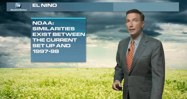
Climate Matters: "
WeatherNationTV
Chief Meteorologist Paul Douglas goes over the El Nino forecast issued
from NOAA. How does this set up compare to previous El Ninos? And what
can we expect from the long range forecasts? Will this help or hurt the
historic drought situation across the West?"
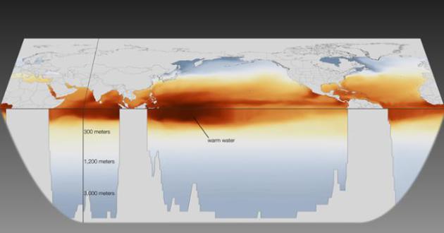
A Brewing El Nino? Here is more information from
NOAA on a growing possibility of an El Nino warm phase of ENSO in the Pacific for later in 2014: "
The
NWS Climate Prediction Center has issued an El Niño Watch, indicating a
possibility of El Niño developing during the summer or fall. El Niño,
which is marked by warmer-than-average sea surface temperatures in the
eastern Pacific Ocean near the equator, is known for influencing weather
across the U.S. and other parts of the globe. Currently, the Climate
Prediction Center is monitoring a very warm
pool of water in the Western Pacific, and is seeing this pool move
eastward, which will likely warm the Eastern Pacific in the coming
months."
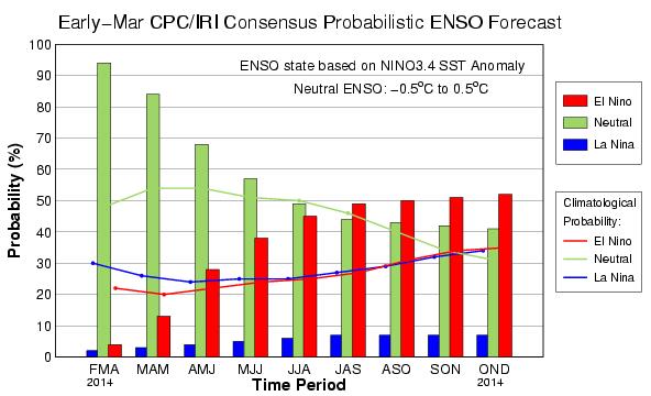
52% Probability Of El Nino By Late Summer. More details via NOAA: "
The
Climate Prediction Center (CPC) consensus forecast on ENSO conditions
shows a 52% probability of El Nino conditions by late this summer and
fall 2014. therefore, an El Nino Watch has been issued for this
potential. The chart below shows the red bars associated with El Nino
increasing in time from left to right. OND stands for the months of
October-November-December."
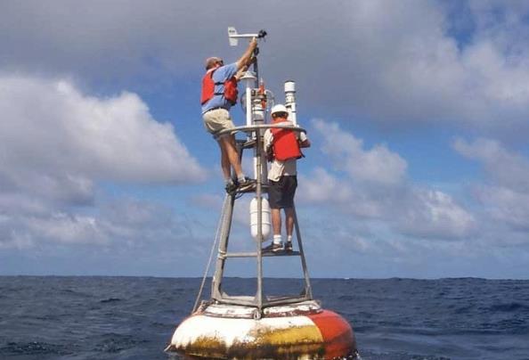
El Nino Monitoring System In Failure Mode. Well that's convenient - one of many potential impacts of budget cuts?
Nature has the article; here's the introduction: "
An
ocean-monitoring system that extends across the tropical Pacific is
collapsing, depriving scientists of data on a region that influences
global weather and climate trends. Nearly half of the moored buoys in
the Tropical Atmosphere Ocean (TAO) array have failed in the past two
years, crippling an early-warning system for the warming and cooling
events in the eastern equatorial Pacific, known respectively as El Niño
and La Niña. Scientists are now collecting data from just 40% of the
array..."
Photo credit above: "
Nearly half of the buoys in the Tropical Atmosphere Ocean array have failed because of delayed maintenance." NOAA.
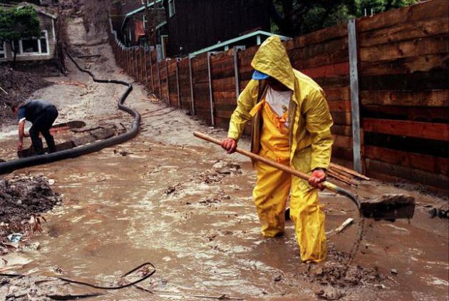
One Way To End A Drought.
El Nino correlates with a (much) more active southerly branch of the
jet stream, often pushing big, wet, sometimes violent storms into
California and the western USA. Such was the case in 1998, the most
extreme El Nino event ever measured. Additional heat from the oceans
contributed to 1998 being the warmest year ever measured, worldwide.
Photo credit above: "
In this Wednesday, March 25, 1998 file photo,
Enrique Lagunas digs a trench to redirect water toward a street in
Laguna Beach, Calif. after heavy rains from an El Nino storm hit
Southern California. On Thursday, March 6, 2014, the U.S. National
Oceanic Atmospheric and Administration announced their prediction of an
El Nino warming of the central Pacific Ocean in 2014 that will change
weather worldwide. It is expected to trigger fewer Atlantic hurricanes,
more rain next winter for drought-struck California and southern states
and even cause a milder winter for the nation's cold-struck northern
tier next year, meteorologists say. For the world it can mean an even
hotter year coming up and food crop losses." (AP Photo/Orange County Register, Bruce Chambers)
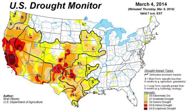
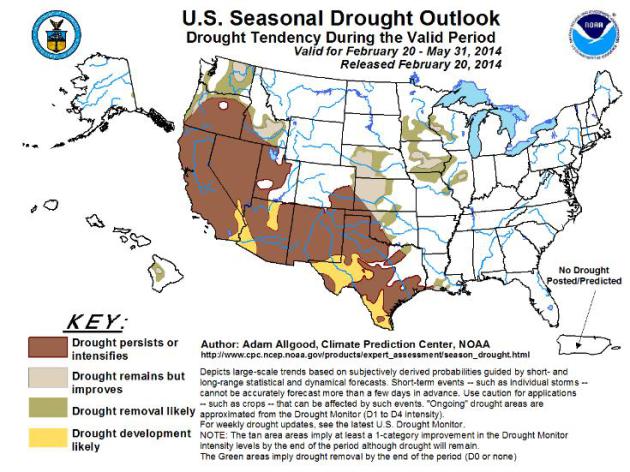
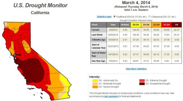
Not Much Long-Term Drought Relief For California.
Last week's rains helped (to settle the dust), but they didn't do much
to replenish depleted reservoirs, aquifers or snowpack in the Sierra.
Much of California is still in the "Exceptional Drought" designation -
pockets of moderate drought as far north and east as central Minnesota.
Map:
NOAA.
An Encouraging Drought Outlook For The Upper Midwest.
NOAA is predicting "Drought Removal Likely" for portions of Minnesota,
Wisconsin and Iowa in the coming months, but persistence, possibly
intensification of drought from Texas into much of the western USA.
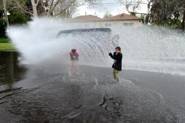
How Recent California Rains Could Make Wildfire Season Worse. It seems counterintuitive, but
Climate Central explains; here's the introduction: "
The massive Pacific storms that streamed onto the California shoreline dropped a lot of rain, but they did little to ease long-term drought conditions and may end up exacerbating what is already expected to be a disastrous wildfire season. This week’s U.S. Drought Monitor,
released Thursday morning, shows that the “blockbuster” storms
that lasted from Feb. 26 to March 2, dropped as much as 75 percent of
the moisture some California cities have received all season. Burbank
received 4.78 inches of its 5.28-inch season-to-date rainfall total and
downtown Los Angeles received 4.52 inches of its 5.72-inch total..."
Photo credit above: "
Children
get splashed by a passing car while playing in a puddle in Long Beach,
Calif., Sunday, March 2, 2014. The storm, the largest since 2010, kept
emergency planners and rescue crews busy, but it did not produce enough
rain to pull California out of a crippling drought that has grown to
crisis proportions for the state's vast farming industry." (AP Photo/The Orange County Register, Anibal Ortiz)
 Colorado State Hurricane Outlooks To Continue, For Now.
I'm always vaguely amused when these hurricane predictions come out
around June 1, looking 2-6 months into the future. Last year was
especially rough, but according to this story at
USA Today, the hurricane hand-waving will continue in 2014: "
They
didn't want to end on such a sour note. Following the self-described
"worst" seasonal hurricane forecast in 30 years in 2013, Colorado State
University (CSU) meteorologists Phil Klotzbach and William Gray were at
risk of losing funding for their well-known Tropical Meteorology
Project. But there is hope for this season, at least for now: "While we
are not fully funded, we have made some reasonable progress in obtaining
funding over the past few weeks," Klotzbach writes in an e-mail..."
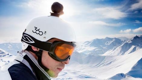
360 Fly Captures Interactive, Panoramic Video. Move over GoPro? For those who need a full 360-degree view there are new options to clamp onto your helmet; details from
gizmag.com: "
Though
moving around panoramic photos can feel fairly natural, the ability to
do so in a video still feels a little unusual. Perhaps it's because
there's a sense that you're always missing part of the recording.
Nonetheless, panoramic video is gradually moving into the mainstream,
with EyeSee360 announcing two offerings that will join the market later
this year..."
Smile! A Short Guide To A Long Life. Here's a clip from an informative book review and article at PBS
Next Avenue: "...
Smiling
is a great stress reliever. It boosts pain-killing, brain-happy
endorphins, and as I say in the book, it takes only 17 muscles to smile
and 43 muscles to frown. I also believe you should avoid multivitamins
because studies show they block the body’s natural ability to control
itself — you disrupt a system we don’t fully understand yet. However, I
do believe in taking statins if you are over the age of 40 because we
now know they don’t just lower cholesterol but they lower inflammation,
which has a profound effect on reducing things such as heart disease,
still the No. 1 killer of men and women. In the end, the data points to
multivitamins and supplements raising your health risks but statins
reducing death..."
An iPhone Case That Plays Doctor.
Because I absolutely want to be monitoring my heart rate when I'm
sprawled on the couch watching "The Walking Dead". Details from
Gizmag: "
Health
monitoring start-up Azoi has announced the availability of a
significant product in the form of the Wello, a thin lightweight
smartphone case embedded with sensors that measures blood pressure,
electrocardiography (ECG), heart rate, blood oxygen, temperature, and
lung functions to a high level of accuracy. The US$199 Wello case will
be initially available for iPhone 4S, 5 and 5S, but for those who don’t
have one of those phones, the case will still work with any IOS or
android device which has Bluetooth LE functionality – you just won’t be
able to use the case on your phone..."
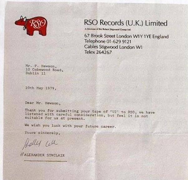
10 Rejection Letters Sent To Famous People. I felt better after reading this article at
Mental Floss. How would you like to be the (doofus) who rejected U2? "
We’ve
all heard that the road to success is paved with failure. But that
doesn’t make rejection any easier to swallow. What does help? Knowing
that the world’s most talented people have been there, too. Here are 10
actual rejection letters that prove it..."
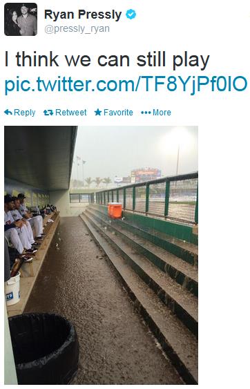
Another Sign Of Spring.
Why should weather-disappointment be confined to snow, ice and the
dreaded Polar Vortex? Thursday's Twins Exhibition game was rained out in
Fort Myers by a squall line: torrential rains and high winds. Reminder:
The
Twins Home Opener is April 7 against the Oakland Athletics.
From Your Faithful Weather Servant, Paige Dorniels.
Have you tried Travoltifying your name? It's free, which is a very good
thing. If you're looking to waste a little time and have a good laugh
check out the link at
Slate.
Climate Stories....
Draft U.N. Report: Global Warming Could Cost $1.45 Trillion. I'm
not sure how you even put a dollar amount on the financial implications
yet, between rising sea level, more intense and long-lasting drought,
and a potential increase in extreme weather events. That said, here's a
clip from a story at
Live Science: "
The effects of global warming
could cost the world $1.45 trillion in economic damages, with the
planet's crop production projected to decline up to two percent every
decade, according to news coverage of a new UN report. The new figures
were detailed in a draft of an upcoming report from the Intergovernmental Panel on Climate Change (IPCC), which will be publicly released later this month during a meeting in Yokohama, Japan, reported The Economic Times..."
Clarifying The Discussion About California Drought & Climate Change. Here's an excerpt of a post from Peter Gleick at
scienceblogs.com: "
In
the last few months, as the severe California drought has garnered
attention among scientists, policymakers, and media, there has been a
growing debate about the links between drought and climate change. The
debate has been marked by considerable controversy, confusion, and
opaqueness. The confusion stems from the failure of some scientists,
bloggers, reporters, and others to distinguish among three separate
questions. All three questions are scientifically interesting. But the
three are different in their nuance, their importance to policy, and
their interest to politicians and water managers. Here are the three
different questions:
- Is the California drought caused by climate change?
- Is the California drought, no matter the cause, influenced or affected by climate changes already occurring?
- How will climate changes affect future drought risks in California?
These questions are not the same thing..."
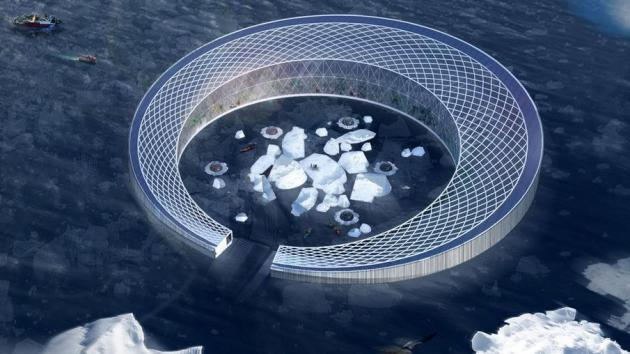
Floating Farm Harvests Water From Floating Icebergs. Here's a novel approach to finding fresh water from all that (rapidly) melting ice up north, highlighted in a
Mashable story: "
Fresh
water is becoming scarce. At the same time, rising global temperatures
are melting the ice caps. One group of architectural students wants to
put the melting ice to practical use. Meriem Chabani and colleagues won
first prize in the latest Jacques Rougerie Competition for their Arctic Harvester,
which is designed to support 800 people. The idea is to float this
donut-shaped facility off the coast of Greenland, where workers would
collect small bergs from the surrounding area and move them into a
central bay where they'd melt..."
Image credit above: Meriem Chabani, Etienne Chobaux, John Edom, Maeva Leneveu.