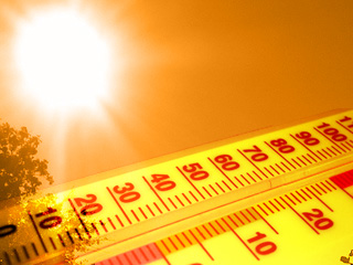
Bragging Rights
I
suspect a conspiracy, a vast cover-up. This winter is turning into a
snowbird machine. People who never considered moving to Scottsdale or
Ft. Myers are starting to do the math.
Minnesota is home for me,
but I find myself accepting odd speaking requests in warmer climes,
anxious to learn more about the intricacies of tropical meteorology. Any
excuse to escape.
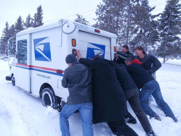
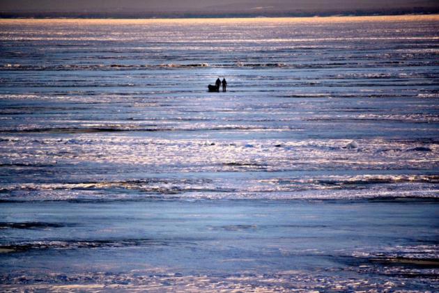
Primal scream time: today is the 50th subzero
morning of winter. Average is closer to 27. Oddly enough no record lows
in the Twin Cities metro this winter, but cold enough. NOAA reports the
9th coldest meteorological winter on record in Twin Cities but 4th
coldest at St. Cloud (62 subzero lows) and the coldest on record at Eau
Claire.
TPT Almanac boss Brendan Henehan reminded me that -15F Sunday morning marked the coldest March temperature since 1962.
Steve Reckers of New Hope reports the coldest February at New Hope since he started keeping records in the mid-50s.
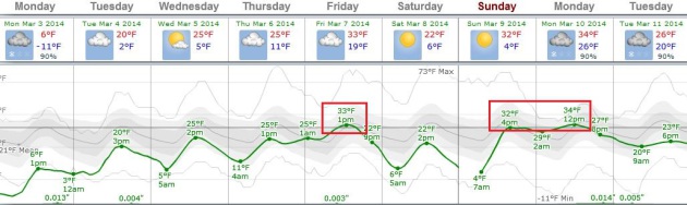
We are so due for a thaw. I can't promise robins and daffodils anytime soon, but 30s are showing up on the 7-Day.
Then
again there are advantages to being frozen in time. Fewer ice dams and
spring flood warnings. Be careful what you wish for in 2014.
* File photo: WJON AM 1240 in St. Cloud.
50 Nights of Subzero Lows in the Twin Cities.
Let me try and put this into perspective: if we pick up just two more
nights below zero that will be the most since 1888. Details from the
Twin Cities National Weather Service.
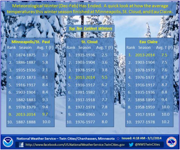
Top 10 Coldest Meteorological Winter.
The Twin Cities metro came in at #9, but it was the 4th coldest
December thru February period for St. Cloud, and the coldest ever
observed at Eau Clairie. More details and graphs from
NOAA.
Historic February?
Meteorologist Dean DeHarpporte forwarded along a note from one of his
friends, Steve Reckers, who was amazed by the February he tracked in his
back yard. Here is an excerpt of that e-mail:
"
I have just
witnessed a truly remarkable Feb., the likes of which I am quite sure I
will never witness again. It turned out to be the coldest Feb. in my
record at 7.8 dating back to the mid 50s (see attached). The second
coldest was 1989 at 8.6 and third coldest was 1979 at 8.7. The Dec.-Feb.
winter was the second coldest at 8.5, 1978/79 was the coldest at 7.9
Today marks the 57th day of zero or below beating the record set in
78/79 at 56. Just counting below zero temps. I now have recorded 54."
- Steve Reckers, New Hope Weather Observer
Hope.
After this mornings muted pain it's theoretically possible we may the
rest of the week without enduring another subzero low, at least the
ECMWF guidance is suggesting that. 30s are possible by the end of the
week, again early next week. Graph: Weatherspark.
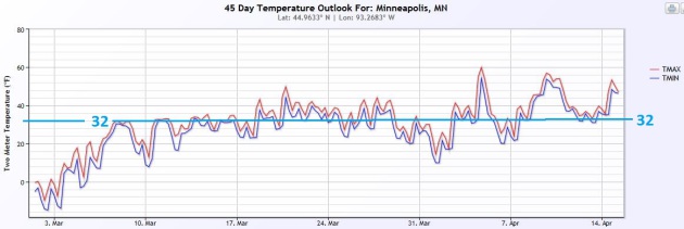
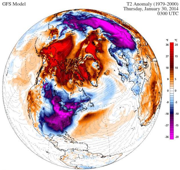
Spring Is Coming - The Atmosphere Just Doesn't Know It Yet.
For the sake of mental health workers statewide I wanted to include the
latest NOAA CFS (Climate Forecast System) model solution for MSP. Odds
are it'll be off, but I suspect the trend is correct. Graphic: Ham
Weather.
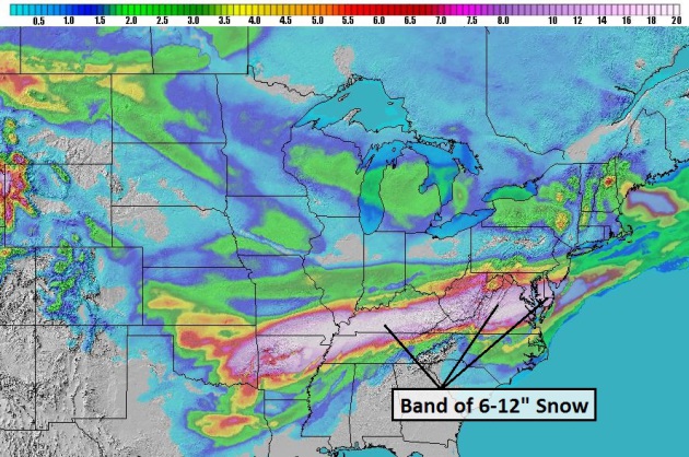
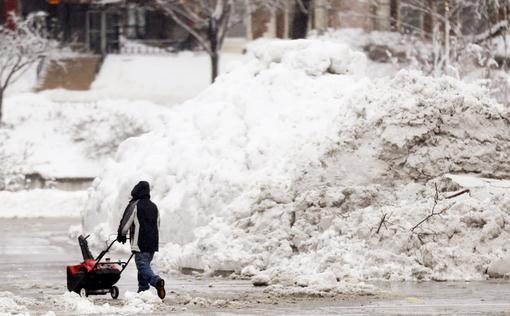
A New Form Of D.C. Gridlock.
Politics will have nothing on the weather in Washington D.C. today. The
atmosphere always bats last, as will be evident in our nation's
capital, where as much as 8-12" snow may pile up today. In a city where
the mere mention of "flurries" can incite panic, imagine what a cool
foot of snow is capable of? Heavy snow and ice is spreading east across
the Virginias and Maryland into Delaware today - travel to the East
Coast will be impacted. NAM data courtesy of NOAA and Ham Weather.
States of Emergency
- Declared in Delaware
- Mississippi Governor declared one for northern MS
- Federal offices in Washington DC closed due to heavy snow and ice risk
- DC schools, along with those in Howard and Charles Counties in nearby Maryland, are also closed today.
- Fairfax County (VA) schools/offices closed today
- University of Oklahoma closing campus for today
* Thanks to Chris Bianchi at WeatherNation for the update.
Cold Perspective.
Here's an excerpt of a note I received Saturday night from TPT Almanac
Executive Producer Brendan Henehan, who did a great job summarizing just
how unusual nighttime lows of -10F or colder in March really are. The
mercury sank to -15F Sunday morning, equally cold this morning. Here is a
portion of Brendan's e-mail:
"
In the past 75 years
--according to my tally-- there have been sixteen days in March in the
Twin Cities when the temp was 10 below or colder. We are expected to
add two more to this historic number this weekend. The National Weather
Service forecast lows for (Saturday night) and Sunday night in the Twin
Cities is 14 below. If it gets to -12F either night it will be the
coldest Twin Cities March temp since 1962. And this weekend will almost
surely constitute the coldest back-to-back March nights in the Twin
Cities since 1948. But don't worry... the record for the coldest Twin
Cities March temp in the past 75 years is safe and secure. On March 1,
1962 the mercury dipped to 32 below in Minneapolis and St. Paul. Let's
let that one stay a record."
Full List of -10 and Colder Twin Cities March Readings since 1939
3-2-1943 -11
3-10-1948 -17
3-11-1948 -27
3-2-1950 -13
3-9-1951 -10
3-7-1955 -11
3-4-1960 -10
3-5-1960 -14
3-7-1960 -16
3-1-1962 -32
3-6-1962 -10
3-7-1967 -10
3-2-1972 -11
3-4-1978 -11
3-26-1996 -10
3-9-2003 -10
Europe's Flood Losses To Soar By 2050.
Scientific American has the article; here's the introduction: "
Extreme
floods like those swamping parts of Britain in recent months could
become more frequent in Europe by 2050, more than quadrupling financial
losses, if climate change worsens and more people live in vulnerable
areas, research showed on Sunday. The study said instances of very
extreme floods, which now occur about once every 50 years, could shorten
to about every 30 years, while cases of extreme damage now occurring
once every 16 years could shorten to once every 10 years..."
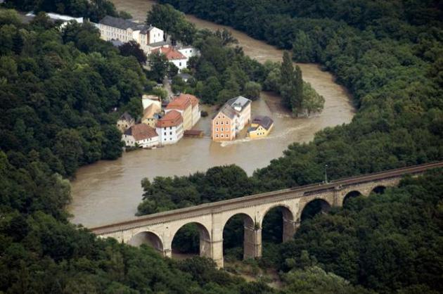
File Photo above: "
An
aerial view of the Neisse river near Goerlitz, Eastern Germany,
photographed on Sunday Aug. 8, 2010. The flooding in central Europe has
struck an area near the borders of Poland, Germany and the Czech
Republic." (AP Photo/ddp/ Jens Schlueter).
Los Angeles, Here's How To Drive In The Rain.
Now before you scoff or laugh, keep in mind that it rained HARD late
last week with widespread street flooding. But I thought it curious that
The Los Angeles Times ran an article reminding locals how to drive in the rain; here's an excerpt: "...
Here's
an "am I doing everything I can to avoid a wreck" checklist. Work your
way down. It could help keep you, and all those drivers hurtling
alongside you, safe:
Pan and scan
Keep your eyes scanning the roadway to avoid road debris and look out for disabled vehicles in reduced-visibility conditions.
Slow. Down.
Driving
at reduced speeds helps you prepare for sudden stops due to debris and
other hazards. Reduce your speed -- particularly as you drive through
puddles..."
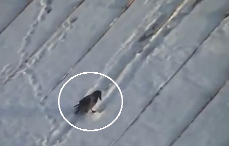
One Of The Funniest Things I've Ever Seen: "Crow-Boarding". Feeling blue about the 428th wind chill advisory of winter? Take the time to watch this
YouTube clip from Russia. No, you can't make this stuff up.
Climate Stories...
Is The Arctic Really Drunk, or Does It Just Act Like This Sometimes?
Is rapid warming of the Arctic and northern latitudes impacting the jet
stream, causing weather to become "stuck"? More research is needed to
help scientists connect the dots. I'm seeing this on the weather maps,
but what's causing it? Chris Mooney from
Mother Jones has the article; here's an excerpt: "...
This
weather now serves as the backdrop—and perhaps, as the inspiration—for
an increasingly epic debate within the field of climate research. You
see, one climate researcher, Jennifer Francis
of Rutgers University, has advanced an influential theory suggesting
that winters like this one may be growing more likely to occur. The
hypothesis is that by rapidly melting the Arctic, global warming is
slowing down the fast-moving river of air far above us known as the jet
stream—in turn causing weather patterns to get stuck in place for
longer, and leading to more extremes of the sort that we've all been
experiencing. "There is a lot of pretty tantalizing evidence that our
hypothesis seems to be bearing some fruit," Francis explained on the
latest installment of the Inquiring Minds podcast.
The current winter is a "perfect example" of the kind of jet stream
pattern that her research predicts, Francis added (although she
emphasized that no one atmospheric event can be directly blamed on
climate change)..."
This Wicked Winter And Climate Change. Is climate volatility flavoring all weather now? Here's a portion of an interesting read at
Discovery News:
"...This is a speculative and genuinely controversial area of the
science," said climate scientist Michael Mann of Penn State University.
"
There are some leading climate scientists who have provided evidence
that climate change may be leading toward more persistent weather
anomalies which can, for example, give the sort of extended periods of
cold seen in the eastern and central U.S. this year, but at the expense
in this case of a very warm western U.S. and unprecedented winter warmth
in Alaska, and record warmth in many parts of Europe." Perhaps one of
the most under-reported weather facts this winter is that almost every
place except the central and eastern United States has been abnormally
warm this winter." AP Photo: Orlin Wagner.
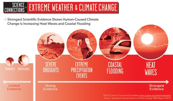
Evidence Check: Which Extreme Weather Events Are More Linked With Climate Change - Heat Waves or Hurricanes?
Which weather events are more likely to be influenced (spiked) by a
warmer, in many cases wetter atmosphere? Here's a clip from
The Union of Concerned Scientists: "...
The SREX report uses different ways of conveying scientific evidence, agreement and confidence
regarding different weather phenomena, including how those phenomena
have been changing over the past 50 years and attributing if
human-caused climate change has played a nonexistent, minor, or major
role in driving those changes. There were traditional likelihood terms
defined by the IPCC such as “likely” (66 to 100 percent probability) or
“very likely” (90 to 100 percent probability) to describe these
relationships as well as expressions of scientists’ overall confidence
in their findings, which ranged from low to medium to high..."
Hotter Extremes Belie Warming "Pause". Warm areas are getting warmer, which is what climate models were predicting 30 years ago. Here's a clip from a story at
Climate News Network: "...
It
quickly became clear the so-called ‘hiatus’ in global average
temperatures did not stop the rise in the number, intensity and area of
extremely hot days,” said Lisa Alexander of Australia’s Centre of Excellence for Climate System Science.
“Our research has found a steep upward tendency in the temperatures and
number of extremely hot days over land and the area they impact,
despite the complete absence of a strong El Niño.” And her colleague
Markus Donat added: “There has been no pause in the increase of warmest
daily extremes over the land and the most extreme of the extreme
conditions are showing the largest change..."
How To Debate Climate Change Deniers (Without Scaring Them Off).
Salon has the story - here's an excerpt: "...
On
the one hand, blaming big companies for climate change can come off as
reactionary, strident, and disingenuous. After all, every individual has
a carbon footprint and therefore contributes to climate change, even if
she takes the bus and buys organic eggs. Who are we to blame companies
for providing the consumer goods that we demand? I am part of the
problem: I drive a car, fly to conferences, buy cheap clothes at Target.
Who am I to point a finger at the oil, airline, and garment industries?..."