By Todd Nelson
Tick tock, tick tock... Why do I always feel like the world is going to flip upside down when the clock strikes midnight on New Year's Eve? Maybe I still have a bad taste in my mouth from the much hyped "Y2K Bug" 14 years ago. Other than being cold, I'm hoping there are no glitches as we turn the page to a new year Tuesday Night.
Thru the end of December, we'll have seen 11 sub-zero nights, all of which have occurred in December! January is typically the coldest month of the year with 10 sub-zero nights; December typically sees around 6. According to NOAA's NOWData, the Twin Cities has around 24 sub-zero nights during the entire winter season; the threat of sub-zero nights generally fades by early March.
Extreme cold is helping to shove the storm track just south of the Twin Cities Metro. Another fast moving clipper system will dive through the High Plains towards Chicago during the day Tuesday and bring a plowable snow chance to Chicago by New Year's Day!
I am happy to report that teens are in the forecast by the end of the week, that'll feel nice. Don't get used to it though as another cold blast looks to arrive early next week. UGH! -Todd Nelson
____________________________________________________________________________
MONDAY NIGHT: Light snow tapers early. Gradual clearing and cold again!. Low: -13. Feels Like: -25F Wind: WNW 5.
NEW YEAR'S EVE DAY: Clouds thicken, light snow possible in extreme southern MN (generally alon I-90). High: -1. Feels Like: -25F. Winds: N 5-10
NEW YEAR'S EVE NIGHT: Chance of a few flurries in southern MN, still very cold. Low: -10. Feels like -25F
NEW YEAR'S DAY: Cold! A few flakes to ring in 2014?. High: 1. Feels Like: -20F
THURSDAY: Increasing sun, still quite cold.Wake-up: -10. High: 0
FRIDAY: Warmer! Increasing clouds, light snow possible over night. Wake-up: -12. High: 11.
SATURDAY: Lingering AM snow. Breezy. Wake-up: 8. High: 18.
SUNDAY: Light snow, turning colder again. Wake-up: 1. High: 10.
MONDAY: Harsh wind returns. Wake-up: -12. High: -2.
______________________________________________________________________________
This Day in Weather History
December 31st
1999: Balmy end to the 2nd millennium over Minnesota with temperatures in the 30's over central and southern Minnesota near midnight.
1937: Damage done by flood at Grand Marais. 18 inches of snow dumped on Grand Portage.
1913: New Ulm had its fortieth consecutive day without precipitation.
______________________________________________________________________________
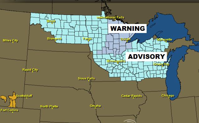
Wind Chill Concerns
Surprise, surprise. Wind chill concerns continue across parts of the Midwest, where temperatures seem to be their coldest.
...VERY COLD WIND CHILLS EXPECTED THROUGH TUESDAY MORNING...
A REINFORCING BLAST OF ARCTIC AIR WILL SPREAD ACROSS THE REGION TONIGHT THROUGH TUESDAY. NORTHWEST WINDS COMBINED WITH CONTINUED COLD TEMPERATURES WILL PRODUCE WIND CHILL VALUES OF 20 BELOW ZERO TO 40 BELOW ZERO AT TIMES. THE COLDEST AIR WILL BE FOUND NORTH OF A LINE FROM ALEXANDRIA TO MORA...WHERE A WIND CHILL WARNING IS IN EFFECT. SOUTH OF THAT LINE...A WIND CHILL ADVISORY IS IN EFFECT.
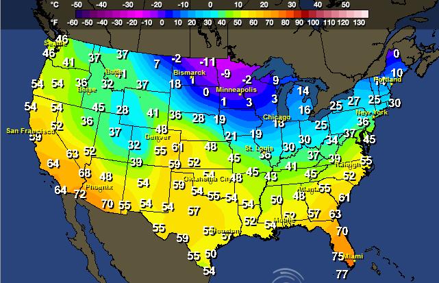
Forecast Highs Tuesday
High temperatures across the Upper Midwest will once again struggle to get above zero for some locations.
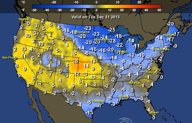
U.S. Highs From Normal Tuesday
It's pretty impressive to see high temperatures nearly 25F below average across the Upper Mississippi Valley, but not that far away, we see high temperature forecasts nearly 15F above average!
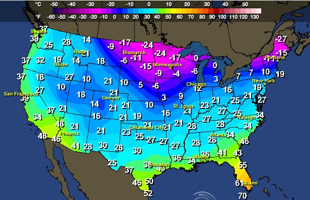
New Year's Eve Night
If you have plans to ring in the New Year across the northern tier of the nation, make sure you bundle up. Take a look at the cold temps expected by AM Wednesday!
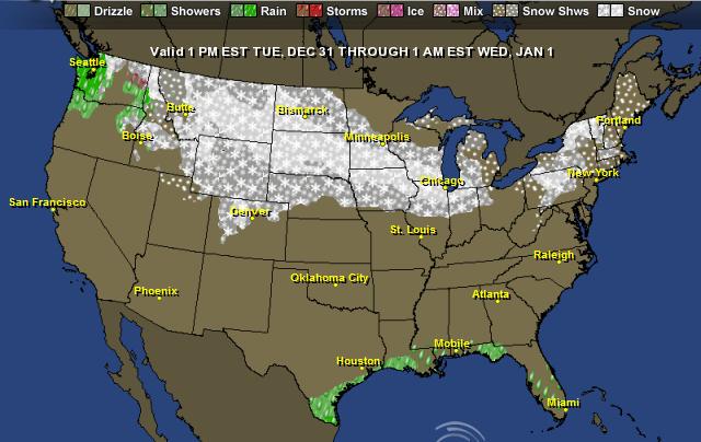
New Year's Eve Forecast
For all the folks heading out and about on New Year's Eve, here's a look at the weather forecast across the country.
Hot Dog?
Thanks to my good friend Michelle Surgeson for this interesting picture out of La Quinta, CA where temperatures have been consistently reaching the upper 70s to lower 80s across much of southern California. At first glance, you would think that this pooch is trying to keep warm by the fire, but in fact, the fire is not lit and is laying on the cooler patio blocks! Looks like a "ruff" life!
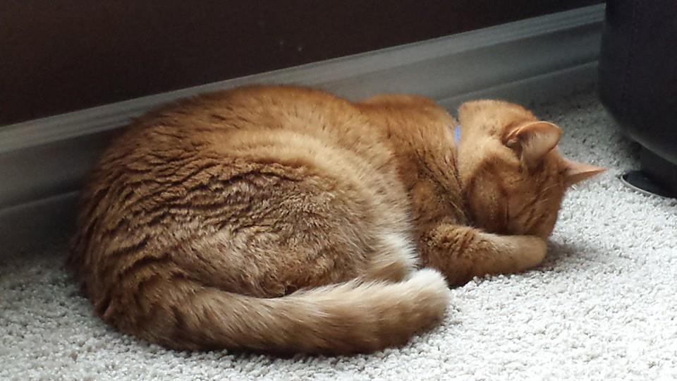
Cold Cat
On the contrary, this cat is laying on a heat vent trying to keep warm. Thanks to my good friend, Matt Dux for this picture out of Kansas City, where Zeus is hogging all the heat!
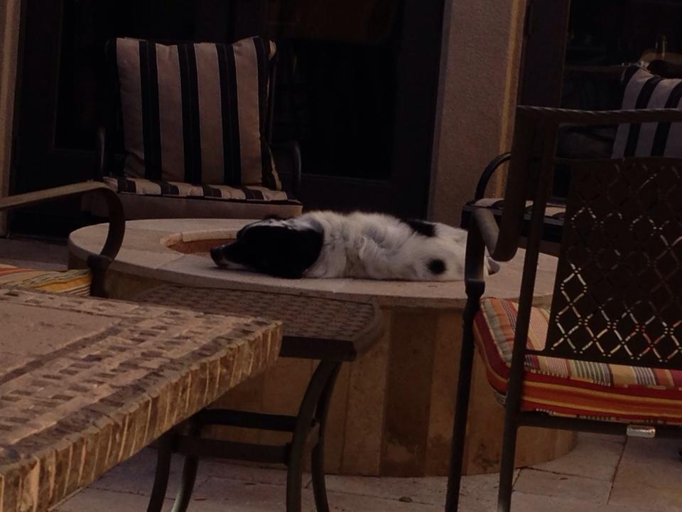
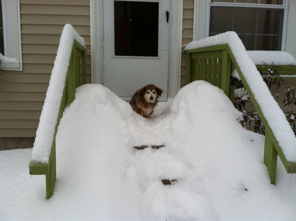
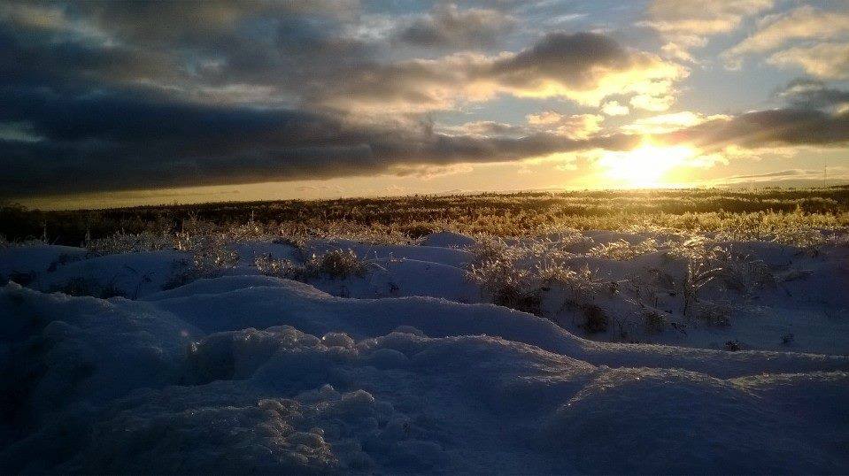
A Pooch on the Porch
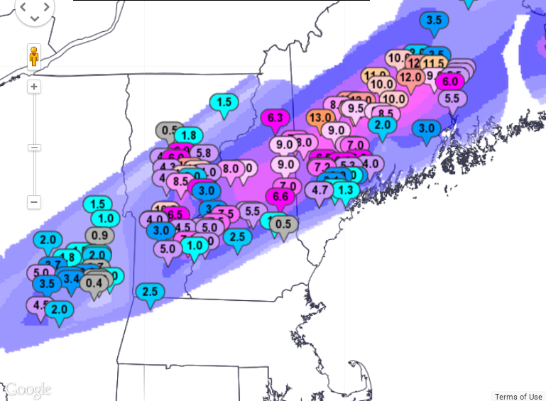
Might as well stay on the animal train... Thanks to @MMilliken47 for this pooch on the porch picture from snowy Belgrade, ME. Snow reports of a foot or more came in after a quick hitting snow storm blew through on Sunday.
Northeast Sunday Snow Map
Here are some of the snow totals from that particular snow event across the northern New England States.
More on the Maine Power Outages
Here's more on the power outages across parts of Maine from the BostonHerald.com
"PORTLAND, Maine — Another snowstorm has knocked out power for more Maine homes and businesses as a stormy December featuring more than 2 feet of snow and a prolonged ice storm draws to a close.
The National Weather Service says the latest snowstorm Sunday night brought the snow total to 26.2 inches in Portland. That's more than double the snowfall in the typical December.
Central Maine Power says about 5,500 customers lost electricity in the latest storm. Bangor Hydro Electric, which is still dealing hundreds of outages from last week's ice storm, says about 1,600 homes and businesses are now in the dark.
Meterologist Mike Cempa says the new year could start the way the old one ended, with another snowstorm. He says a costal storm is on tap for Thursday and Friday."
(Photo Courtesty: Shirley Spong Lynn from Downeast Region, ME)
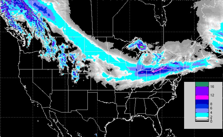
More Snow on the Way
Here's the snow potential through AM Thursday. Note the narrow band of potentiall heavier snow from the High Plains to the Great Lakes to the Northeast during this time. Areas near the Great Lakes Region could see some of the heaviest tallies around New Year's Day (Wednesday) and Thursday.
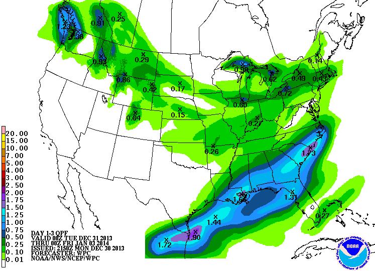
3 Day Precipitation Outlook
According to NOAA's 3 day precipitation outlook, there will be more precipitation across the southern tier of the nation in the form of rain. Some of this could be heavy, especially across southern Texas, where there has already been some heavier tallies over last few days.
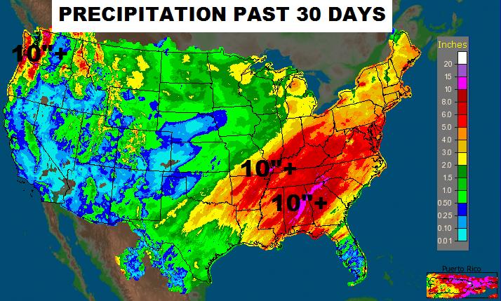
A Wet December (for some)
December has been a fairly soggy month, especially across the Southeastern U.S. and the higher elevations of the Pacific Northwest.
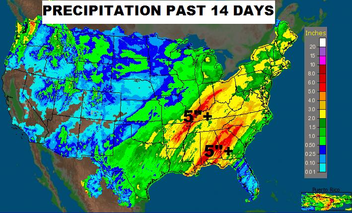
Precipitation Past 14 Days
Precipitation Past 30 Days
U.S. Drought
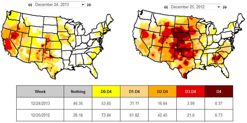
Here's an interesting look at the Drought from this year to last. Note how much more widespread the drought was in the 2012 across the Plains than it is today. However, note how the drought has become much worse across in the western part of the country, espeically in California.
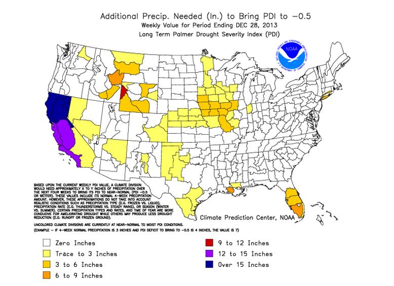
How Much Rain Are We Talkin' Here?
According to the Palmer Drought Severity Index:
"The Palmer Drought Severity Index (PDSI) (known operationally as the Palmer Drought Index (PDI)) attempts to measure the duration and intensity of the long-term drought-inducing circulation patterns. Long-term drought is cumulative, so the intensity of drought during the current month is dependent on the current weather patterns plus the cumulative patterns of previous months. Since weather patterns can change almost literally overnight from a long-term drought pattern to a long-term wet pattern, the PDSI (PDI) can respond fairly rapidly."
This is how much additional precipitation is needed bring the (PDI) to -0.5. This shows that parts of California need a foot of liquid precipitation or more!!
Thanks for checking in and have a great rest of your week ahead!
Don't forget to follow me on Twitter @TNelsonWNTV