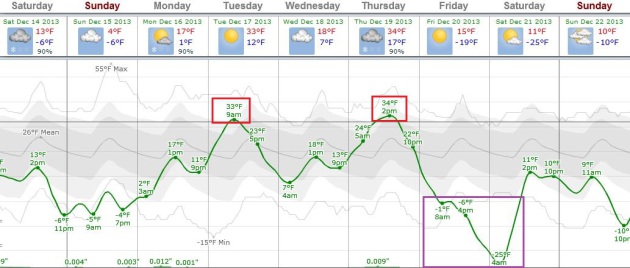
 A Very White Christmas
Yesterday
I asked a friend how he was enjoying December. "Reminds me of
Minnesota" he grinned. Yep, like the good 'ol days, when cold and snow
were a given. Before weather patterns started acting wonky and
strange.<p>If anyone asks (doubtful) 7 out of 10 Twin Cities
Christmases are "white", with at least 1 inch or more of snow on the
ground. This will be one of them.
The older I get the less I take
for granted. Christmas 2011 was brown. In fact since 1899 there have
been 32 years with "zero" or a trace of snow on December 25, according
to the
Minnesota Climate Office.
An
anemic Alberta Clipper drops a candy-coating of fluff today; maybe a
quick inch in some spots. That compares with half a foot in the suburbs
of New York, maybe 8" of slush in Boston by tomorrow - both cities
closer to the main storm track.
Cool, Canadian exhaust lingers
into Tuesday morning - and then we warm up a little. 30s by midweek will
feel like a (bad) Club Med vacation, before another cold wave sweeps
into town late next week. Single digit highs are possible 1 week from
today but temperatures may reach 20s, even 30s by Christmas Day.
Above zero.
Leaving most of us happier than a dog with two tails.
 Moderating Temperatures Next Week
.
If teens feel tolerable, imagine how low 30s might feel next week, the
best chance of a fleeting thaw around midweek. ECMWF guidance shows
another sharp temperature downturn late Thursday into Saturday of next
week.
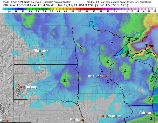 Clipped Again.
Today's clipper, marking the leading edge of colder air of Canadian
origin, may spark an inch or so of powder in the Twin Cities, as much as
2" near Mille Lacs and Sandstone. When it's this cold chemicals don't
melt snow and ice on area highways, so expect slick spots. NAM guidance:
NOAA and Ham Weather.
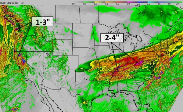
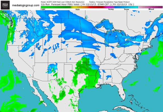 Accumulating Snow Ohio Valley to New England.
A wave of low pressure tracking to the east-northeast spreads
accumulating snow from Columbus and Pittsburgh to New York City and
Boston later today and Sunday, enough to shovel and plow in 18-20
states, with as much as 8-12" over interior New England. NAM Future
Radar courtesy of NOAA and Ham Weather.
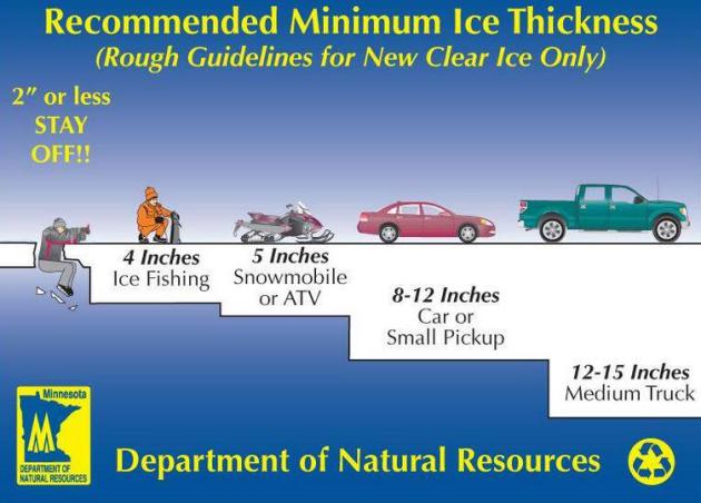
Beware Of Unstable Ice.
We picked up a few inches of snow (a very good insulator) in early
December, before the ice could freeze to a thickness where it safely
supports vehicles - with several high profile cases on the news recently
where trucks and ice houses have gone into the water. Be careful out
there. With frigid weather returning in less than a week the ice will
(gradually) thicken, but most lakes aren't there yet.
Ask Paul. Weather-related Q&A:
"
In
your "arctic myths" article of 12/13/13, you indicate that wind chill
is due to evaporation of sweat. Can you cite your reference for that
conclusion?
It's been over 50 years since I studied
Thermodynamics & Heat Transfer at the U, but wasn't the wind chill
an indication of the rate of cooling and not the wet-bulb temperature?
In fact, weren't the original measurements made with a bottle of water?"
Thank you,
Bruce H. Johnson
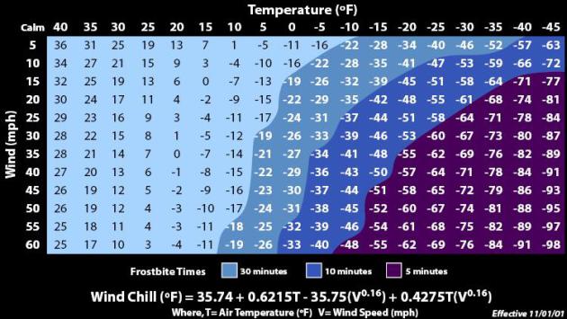
Yes
Bruce, I oversimplified the answer (space is limited in print, but on
the blog I have the luxury of not editing content as much). Evaporation
(evaporative cooling) is only part of the process, along with other
factors. You are correct, original estimates were done on an elevated
water bottle (in Antarctica), but the algorithms for calculating wind
chill were revised (improved?) in 2001. It's still the source of
considerable controversy though among meteorologists. The point I was
trying to make is that, unlike human flesh, an inanimate object, like a
vehicle, can't "feel" colder than the actual air temperature, but a
strong wind will cool an object down to the ambient temperature faster.
Here's an excerpt of an explanation from
Wikipedia: "
The human body loses heat through convection, evaporation, conduction, and radiation.The
rate of heat loss by a surface through convection depends on the wind
speed above that surface. As a surface heats the air around it, an
insulating boundary layer of warm air forms against the surface. Moving
air disrupts the boundary layer, allowing for new, cooler air to replace
the warm air against the surface. The faster the wind speed, the more
readily the surface cools. The speed of cooling has different effects on
inanimate objects and biological organisms. For inanimate objects, the
effect of wind chill is to reduce any warmer objects to the ambient
temperature more quickly. It cannot, however, reduce the temperature of
these objects below the ambient temperature, no matter how great the
wind velocity. For most biological organisms, the physiological response
is to maintain surface temperature in an acceptable range so as to
avoid adverse effects. Thus, the attempt to maintain a given surface
temperature in an environment of faster heat loss results in both the
perception of lower temperatures and an actual greater heat loss
increasing the risk of adverse effects such as frostbite, hypothermia, and death..."
Significant Weekend Storm Northeast and New England. Here's an excerpt of an
Alerts Broadcaster briefing that went out to corporate customers yesterday:
*
Friday the 13th, what can possibly go wrong? Nothing today, but
facilities and travel plans will be impacted from Saturday into Sunday
as a coastal storm spreads a burst of snow, ice and rain into portions
of the Mid Atlantic Region and all of New England.
* Snow will
spread across Pennsylvania and northern New Jersey into New York City
Saturday afternoon, the storm peaking Saturday night as snow mixes with
ice and rain. I'm expecting roughly 4" of heavy, wet, slushy snow in
Manhattan, but closer to 6-8" for suburbs in northern New Jersey and
Connecticut. The storm peaks late Saturday night into midday Sunday from
Hartford to Boston, where some 5-8" amounts are likely; closer to 10"
well inland from the coast, where precipitation will fall as mainly
snow.
* Over a foot of snow may fall from near Albany to the Berkshires to Portland, Maine by late Sunday afternoon.
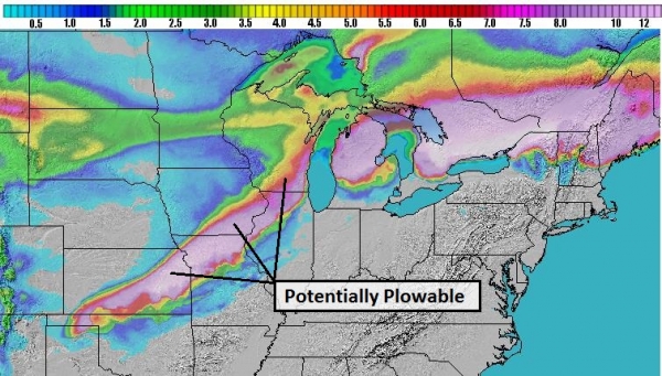
Sharp Cut-Off To The Snow.
Note the lack of (any) snow over most of central and southern New
Jersey. There's a potential for a sharp north-south gradient in snowfall
amounts with this fast-moving system; mostly rain for much of Long
Island, a plowable snow in New York City before changing to rain and ice
Saturday night, but mostly snow from Parsipanny to Ossining and Pound
Ridge to Darien and New Canaan, where closer to 6-9" may pile up by
Sunday morning. NAM model guidance: Ham Weather.
Sloppy, Icy Mix Near The Coast.
Computer models are vascillating back and forth, which makes me more
nervous than usual, but the guidance (I trust) still suggests enough
warm air flowing in from the Atlantic for a rain/ice mix from metro New
York and Long Island to Cape Cod. Farther inland, well north and west of
I-95, I expect more snow than ice or rain. RPM model guidance: WSI
Corporation.
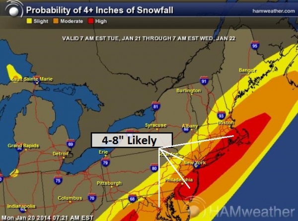
Probably Of 4" or More of Snow.
Our internal models show a high probability of a plowable snowfall from
State College, Allentown and Scranton into north Jersey the suburbs of
New York City, and much of New England, with some 5-8" amounts from
Hartford into the western suburbs of Boston. Map: NOAA and
Ham Weather.
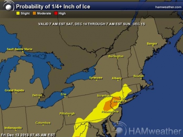
Ice Potential.
At the height of the storm Saturday evening and night a surge of milder
air aloft will change precipitation over to sleet (ice pellets) and
freezing rain, creating a potential for an icy glace from Reading and
Allentown, PA into northern New Jersey and metro New York City. Although
I don't expect a prolonged period of freezing rain -
some power outages are possible, especially eastern PA into north Jersey and southeastern New York state. Map: Ham Weather.
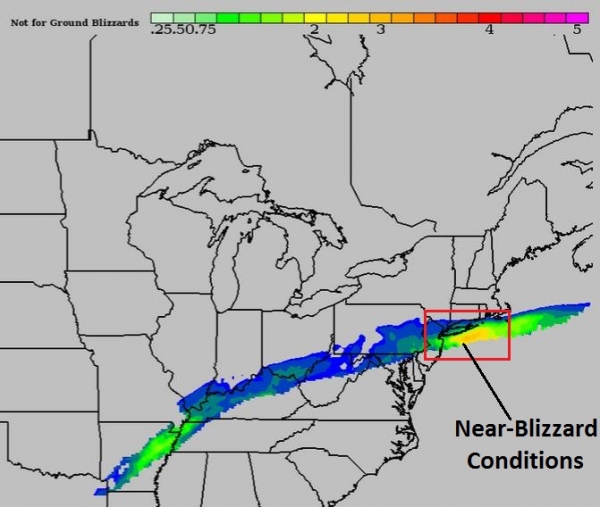
A 4-8 Period Of Heavy Snow.
Our BPI (Blizzard Potential Index) derived model shows conditions
approaching near-blizzard conditions from Long Island Sound to Boston
Saturday night into Sunday morning, with low visibilities and sustained
winds of 20-30 mph. Flights will be impacted from Saturday evening (New
York area) into Sunday (Hartford, Boston and Providence) with conditions
improving from west to east by Sunday afternoon. BPI guidance: Ham
Weather.
Select City Amounts.
I suspect the 7" predicted for New York City is a little high - I'm
thinking closer to 3-5" in midtown Manhattan as ice and rain mixes in at
the height of the storm Saturday night, keeping total amounts down. If
precipitation were to fall as all snow in New York total amounts would
be in excess of 8", but I believe the odds of this happening are less
than 1 in 3. Expect heavier amounts over interior New England, where
enough cold air will be in place for all-snow. Boston will probably wind
up with 4-8", the best chance of 8" over the western suburbs.
Winter Storm Watch Posted.
We alerted you to the heavy snow and ice possibility yesterday, and now
NOAA has issued Winter Storm Watches for much of the Northeast. I
expect these watches to be upgraded to Winter Storm Warnings later today
or first thing Saturday as the storm becomes imminent, capable of
hampering travel and impacting facilities Saturday afternoon into Sunday
morning.
Summary: Underscoring my theory that
we're about to experience a real winter across much of the USA, probably
one of the 2 or 3 coldest and snowiest in 20 years, this weekend will
be character-building from the Delaware Valley to coastal Maine,
impacting an estimated 50+ million Americans. A heavy, wet, slushy snow
will slow things down in New York, with the heaviest amounts from the
suburbs of New Jersey, Westchester County and Connecticut into the
western suburbs of Boston and Portland, where some 5-8"+ amounts are
quite likely by Sunday. Accelerate travel and contingency plans today
and first thing Saturday. Conditions will rapidly deteriorate as the day
goes on tomorrow in the Northeast.
Paul Douglas - Senior Meteorologist - Alerts Broadcaster
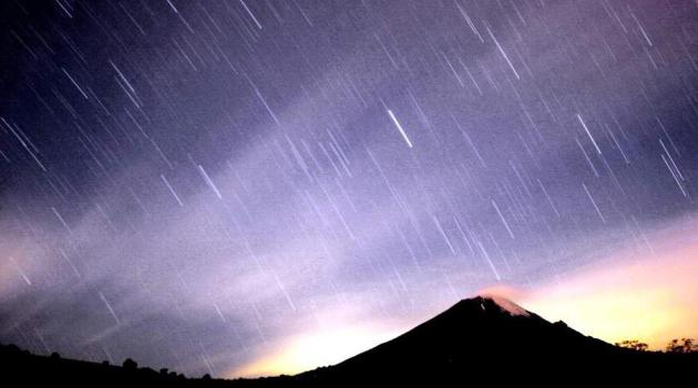
Geminid Meteor Shower To Light Up Skies.
Maybe I'm rationalizing here (not above that), but one advantage of
Canadian air - skies tend to be clear to partly cloudy, increasing the
odds of seeing aurora or meteor displays. Here's an excerpt from
Sky News: "
The
annual Geminid shower can be seen from almost any point on Earth and
astronomers say the best time to see the action is between midnight and
sunrise on December 14. While most meteor showers come from comets,
Geminids is different because the 'parent' is an asteroid called 3200
Phaethon. "Of all the debris streams Earth passes through every year,
the Geminids' is by far the most massive," said Nasa astronomer Bill
Cooke..."
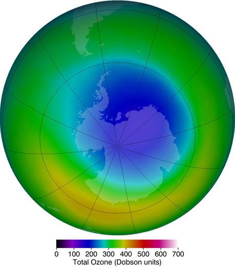
NASA Says Ozone Hole Stabilizing, But Won't Fully Recover Until 2070. Here's the introduction to a story at
The Los Angeles Times: "
The hole in the ozone layer is stabilizing but will take until about 2070 to fully recover, according to new research by NASA scientists. The assessment comes more than two decades after the Montreal Protocol,
the international treaty that banned chlorofluorocarbons and other
compounds that deplete the ozone layer, which shields the planet from
harmful ultraviolet rays. Levels of chlorine in the atmosphere are
falling as a result of the treaty, but have not yet dropped below the
threshold necessary to have a shrinking effect on the ozone hole that
forms each year over Antarctica, according to scientists at NASA's
Goddard Space Flight Center. They presented their findings this week at the annual meeting of the American Geophysical Union in San Francisco..."
Graphic credit above: "The
ozone hole, shown in October, has stopped growing since the mid-1990s,
but scientists say a full recovery is many decades away." (Ozone Hole Watch / December 12, 2013).
The Data Flood.
Managing that flood of data (noise) is increasingly problematic for
many of us. Big Data is the rage, turning that torrent of bits into
something approximating wisdom. Here's a clip of an interesting story at
Student Science: "
There
is a huge amount of information available online. And its volume is
growing at lightning speed. Each minute on average, more than 200
million emails move across the Internet (though most are spam). Twitter
users post more than 300,000 new tweets. People across the globe share
more than 38,000 Instagrams. YouTube users upload another 100 hours of
video. Google processes more than 3.6 millionwebsearches. And 2.2
million things on Facebook get a “like” or a comment. But the Internet
isn’t the only numbers-driven environment packed with information.
Scientists, too, have more information than ever before. It comes from
the study of volumes of raw facts, called data. For example, biologists
collect enormous numbers of measurements on millions of cells and
everything inside them. Astronomers fill banks of hard drives with
observations of stars, galaxies and energy in deep space. Earth
scientists assemble detailed snapshots of weather, including patterns of
winds and waves throughout the world..."
Graphic credit above: "
Modern
life generates huge volumes of data. That data can yield detailed
information — and provide valuable insights. This image visualizes the
volume of Internet data that flows between New York City and cities
around the world over a 24-hour period. The larger the glow at any
particular location, the larger the volume of data." MIT Senseable City Lab.
World's Smallest Pacemaker Can Be Implanted Without Surgery.
Hooray for the Hometown Team, Medtronic! This is pretty amazing, but I
still pray I won't need one of these down the road, although the weather
maps are giving me heart palpatations. Here's a clip from
M.I.T. Technology Review: "
Pacemaker
surgery typically requires a doctor to make an incision above a
patient’s heart, dig a cavity into which they can implant the
heartbeat-regulating device, and then connect the pulse generator to
wires delivered through a vein near the collarbone. Such surgery could
soon be completely unnecessary. Instead, doctors could employ
miniaturized wireless pacemakers that can be delivered into the heart
through a major vein in the thigh. On Monday, doctors in Austria
implanted one such device into a patient—the first participant in a
human trial of what device-manufacturer Medtronic
says is the smallest pacemaker in the world. The device is 24
millimeters long and 0.75 cubic centimeters in volume—a tenth the size
of a conventional pacemaker..."
Photo credit above: "
Tiny ticker: A new pacemaker is small enough to fit inside the heart and can be implanted through a patient’s veins."
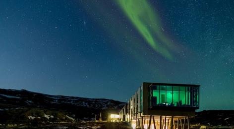
ION Adventure Hotel Basks In The Glow Of The Northern Lights. This almost makes me want to check out Iceland - one more for the endless travel bucket list. Details via
Gizmag: "
While
the use of geothermal energy and recycled materials would normally be
starting points for Gizmag's look at a new holiday destination like the
ION Adventure Hotel, there's one element here that stands well above the
pack – location. The hotel is nestled amidst the diverse Icelandic
landscapes in the heart of the Mt. Hengill region, offering guests the
opportunity to catch a glimpse of the spectacular aurora borealis or
midnight sun, depending on which time of the year it is..."
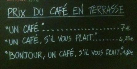
French Cafe Charges Extra For Rudeness. The French. Rude? Say it isn't so. But if you visit this cafe you had better order your pastry with a smile and a "bonjour!".
The Local has the story; here's an excerpt: "
The
French are well-known for their love of everyday formalities. While
much of the Western world can sometimes seem to get through the day with
grunts and nods, the French insist on sprinkling their exchanges with a
“Madame” here and a “C’est gentil” there. Baguette purchases must be
preceded by a mandatory “Bonjour”, and it’s de rigeur to wish complete
strangers a good afternoon, even when leaving an elevator. So what
happens if these standards drop, as can happen from time to time? Well,
for the owners of one café in the south of France, the solution is clear
– hit your rudest clients in their pockets, or at least threaten to do
so..."
Photo credit: "
The owners of a café in the
south of France have struck a blow for good old-fashioned French
politeness, with a sign charging extra for rudeness." Photo: Courtesy of Fabrice Pepino.
Another Sign of Spring? I keep getting Twins tickets updates. Can Opening Day be far behind? You 'betcha!
Climate Stories...
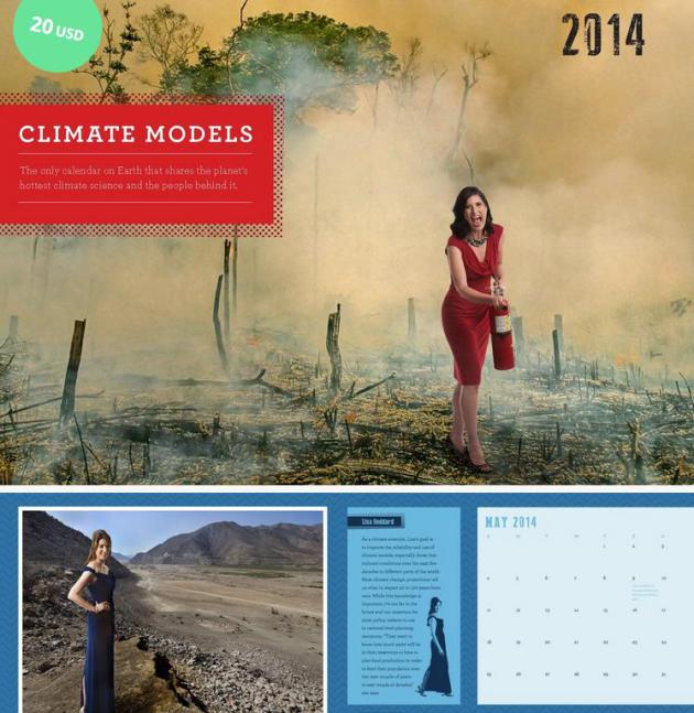
2014 Climate Models Wall Calendar. Yes, an entirely different sort of "climate model", and wouldn't this look good under the Christmas Tree.
Details here: "
In collaboration with photographers Charlie Naebeck and Jordan Matter,
of the New York Times bestseller "Dancers Among Us," we've created a
2014 wall calendar that features 13 portraits of climate scientists and
their research. From studies of drought in the American Southwest to reconstructions of Southeast Asia's climate history using
data obtained from tree rings, the information in the calendar covers a
broad range of current climate science and describes what scientists
are discovering about Earth's past, present and future climate..."
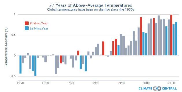
November Was Cold, But The Climate Keeps Warming.
It's hard-wired into our cave-man DNA to look out the window and assume
it's this way (everywhere). Winter has come on suddenly, and hard, but
that doesn't mean the rest of the planet is experiencing what we are, as
described in this article at
Time Magazine; here's a clip: "
Global warming
is a misnomer. “Warming” makes it sound as if the climate will get
hotter at a steady, predictable pace—like a pot of soup heating on the
stove. But that’s not how our enormously complex climate system works.
The increasing concentration of carbon dioxide and other warming gases
in the atmosphere is just one of many factors affecting the global
climate—including the natural year-to-year variability that has always
been at work. Over the short term, temperatures can rise and fall like
the fluctuating value of a single company in the stock market. But the
long-term trends—the important trends—remain unchanged. Case in point:
the National Climatic Data Center revealed yesterday that the average
temperature in the contiguous U.S. in November was 41.6 F—0.3 F below
the 20th century average..."
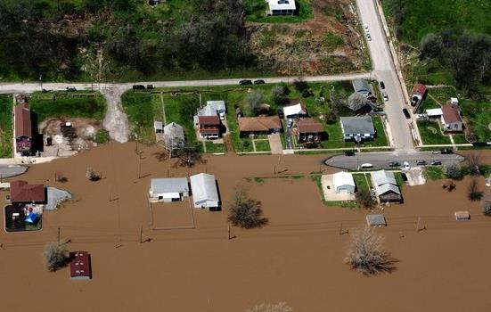
Sea Level And Risk Of Flooding Rising Rapidly in Mid-Atlantic. Climate Central has the story - here's the intro from meteorologist Andrew Freedman: "
During
the 20th century, sea levels along the highly populated U.S.
Mid-Atlantic coastline between New York and Virginia rose faster than
in any other century during the past 4,300 years, according to a new study. And as those sea levels continue to increase as a result of global warming and local land elevation changes, the risks of coastal flooding will dramatically escalate. The study, by geoscientists at Rutgers and Tufts Universities and published in the new journal “Earth’s Future,”
took a comprehensive look at the history of sea level in the
Mid-Atlantic, combining sediment records of prehistoric sea level with
modern data, which includes readings from tide gauges and satellite
instruments. The result is one of the most in-depth examinations of
past, present, and future sea level rise of any region in the U.S..." (Photo credit: AP).
What Cities Can Do To Prepare Themselves For Increasingly Severe Weather. Here's a clip from a story focused on urban resiliency, from
Huffington Post: "...
Cities
across America have good reason to expect that increasingly severe
weather events could bring devastation. Today, a 100-year flood is no
longer a once-in-a-lifetime event. Cities such as New Orleans,
Milwaukee, and Hoboken deal with regular flooding issues. In Miami Beach
and Norfolk, ocean-side streets flood with seawater simply when a high
tide comes in. And in many cities, a mild thunder storm is enough to
overflow sewers and release sewage into fresh water supplies. In these
communities, local leaders are searching for practical, cost-effective
solutions to manage floods, storm water runoff, erosion, and other
negative environmental impacts from storms. Forward-looking cities that
want to better prepare for future severe weather events can take
proactive steps to mitigate the damage of future storms..." (Image: Red Orbit).
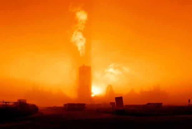
Is Global Warming Stoking An Arctic Cold War?
As polar ice continues to melt, opening up new sea routes and
opportunities for oil and gas exploration (ironic, huh?) expect to see
the arctic emerge as a geopolitical prize, with strategic (and military)
implications.
Grist has the story - here's an excerpt: "
Militarization
and geopolitical maneuvering is heating up in the Arctic as once-frozen
tundras melt into the sea, unearthing a bonanza of oil fields and
shipping routes. Russian Pres. Vladimir Putin this week ordered his military brass
to pay “particular attention to the deployment of infrastructure and
military units in the Arctic.” He said Russia would open two new Arctic
airbases and noted that a long-deserted Russian airbase on the
Novosibirsk Islands was recently reopened..."
Photo credit: Shutterstock /
Sergey Kamshylin.
How Bill McKibbon Ruined My Life. Here's an excerpt of a story at
Huffington Post: "
Other
good news is that McKibben's "Fossil Fuels Divestment Campaign" is
gathering momentum at American universities. The goal? Bankrupt the
fossil fuel industry. (If not financially, then at least tarnish their
reputation by exposing an industry that is profiting from wrecking the
climate.) On college campuses, in the 1980s, activism protesting
apartheid successfully forced the divestment from companies doing
business with South Africa. McKibben hopes to do the same with big oil.
"The fossil fuel industry has five times as much carbon in its reserves
of coal, oil and natural gas as we can safely burn. These are now rogue
industries committed to burning more carbon than any government on earth
thinks would be safe to burn," says McKibben..."