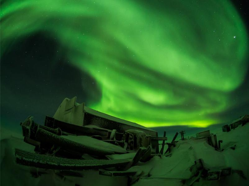
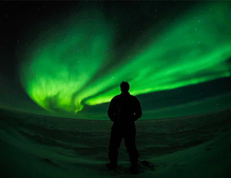
Thanks to my good friend, John Thain for these AMAZING pictures from Barrow, AK! He's an incredibly talented photographer... What do you think?
This is what John had to say about the event this weekend:
"This was one of the most incredible experiences since moving to Alaska - standing on the shore of the Arctic Ocean in Barrow. The weather was warm, the sky was clear, and the aurora was... best described in pictures, not words."
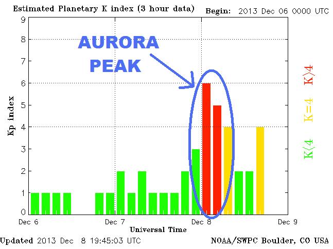
Planetary K Index
Here's a good product to keep an eye on when you know a northern lights event may be possible. The Planetary K Index shows when things become 'more active' - here's what it looked like this weekend!
See the latest K Index HERE:
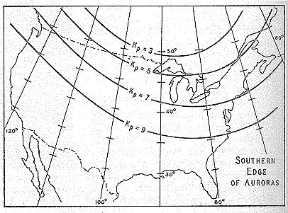
Relationship Between K Index and the Aurora
Here's a brief article from Spaceweather.com on how K Index and the aurora are related.
"The aurora is understood to be caused by the interaction of high energy particles (usually electrons) with neutral atoms in the earth's upper atmosphere. These high energy particles can ‘excite’ (by collisions) valence electrons that are bound to the neutral atom. The ‘excited’ electron can then ‘de-excite’ and return back to its initial, lower energy state, but in the process it releases a photon (a light particle). The combined effect of many photons being released from many atoms results in the aurora display that you see."
Read more HERE:
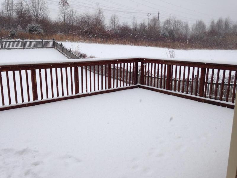
Snowy Sunday
Sunday was kind of a nasty for for folks in the eastern part of the country as a secondary storm system pushed through some of the same areas that got hit just a few days ago. Here are some pictures from the event.
Darnestown, MD
Thanks to my good friend Amy Betwy for this snowy Maryland pic.
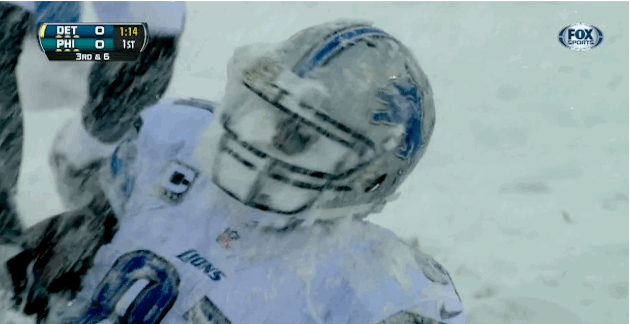
Snowy Lion?
Here's a good one from BleacherReport.com from the Detroit Lions vs. Philadelphia Eagles football game, which was held in Philadelphia... YIKES
"In case you hadn't heard, it's crazy snowy across the NFL landscape, and stadium workers are hard at work trying to keep playing conditions acceptable. Naturally, there is lots of entertainment to be had."
See more from BleacherReport.com HERE:
or how about this one from the Miami Dolphins vs. Pittsburgh Steelers game in Pittsburgh!

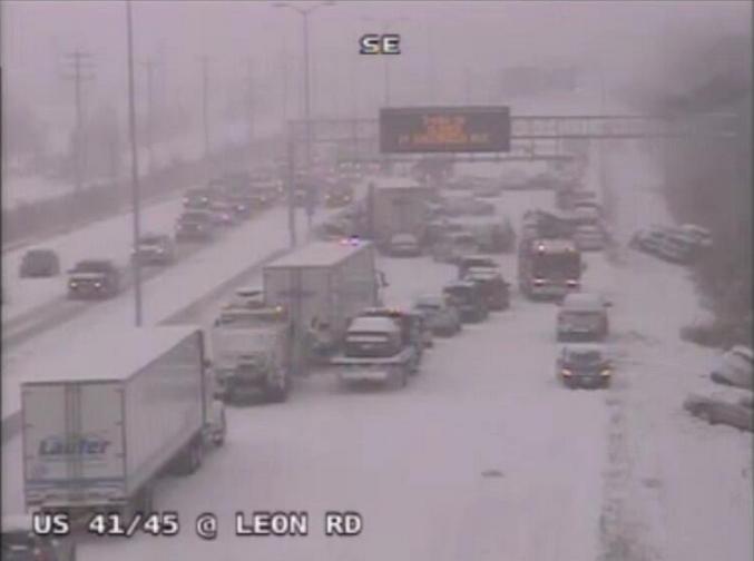
Major Travel Concerns
Unfortunately,
this weather had made for some serious travel concerns. Sunday's snow
lead to this 30 car pile-up near Milwaukee, WI and actually shut down
I-94 for a time.
"A crash on I-94 quickly escalated to at least 30 cars, and shut down the highway from Milwaukee to Chicago.
The
crash comes amid snow falling in the area. While the highway was
completely shut down, the eastbound side has re-opened at Racine County,
the Milwaukee Sheriff Office told the Milwaukee Journal-Star."
See more from TheEpocTimes.com HERE:
(Photo courtesy: WI DOT)
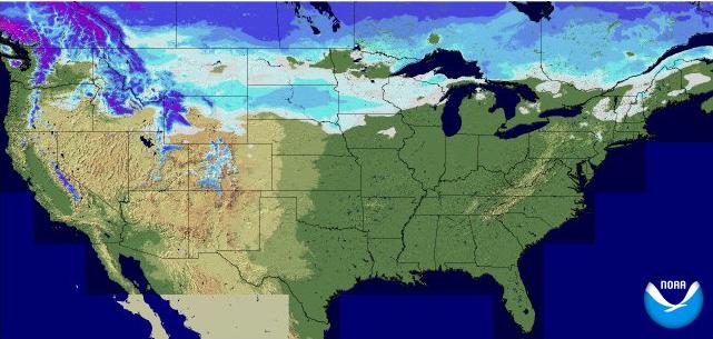
U.S. Snow Cover
This is an impressive map for early December! As of Sunday, 58.5% of the nation was covered in snow! In fact, I don't recal seeing this much snow cover across the nation this early in the season in quite a while!
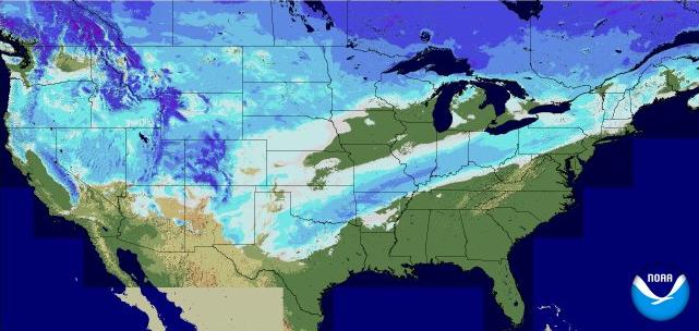
U.S. Snow Cover Last Year: 2012
As of last year, only 18.3% of the nation was covered in snow.
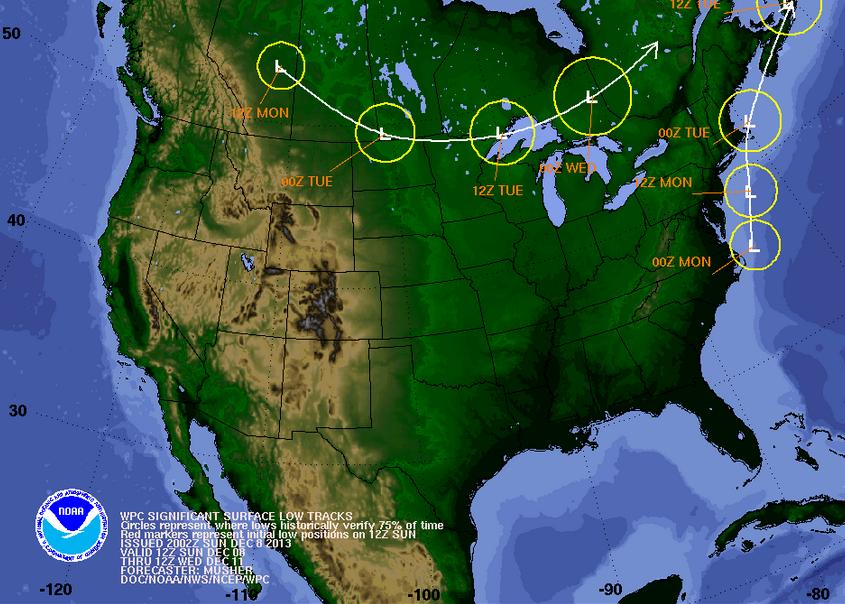
Weather Outlook Thru Early Week
Our wild winter weather scenarios will begin to wind down across the nation thru early week. Monday will still harbor some lingering effects along the eastern part of the country as the low tracks north along the East Coast. By Tuesday, most of the wild weather in the eastern part of the country will be fading, but a weak clipper system will flirt with the international border Monday/Tuesday and kick out a little snow.
Snow Potential
Plowable snows will still be ongoing across parts of the northern New England States, but the wintry mess that most encountered on Sunday will turn to a cold rain farther south. Note the thin band of snow potential from New Mexico to the Ohio Valley thru AM Tuesday...
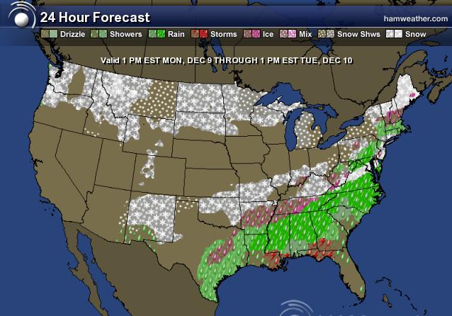
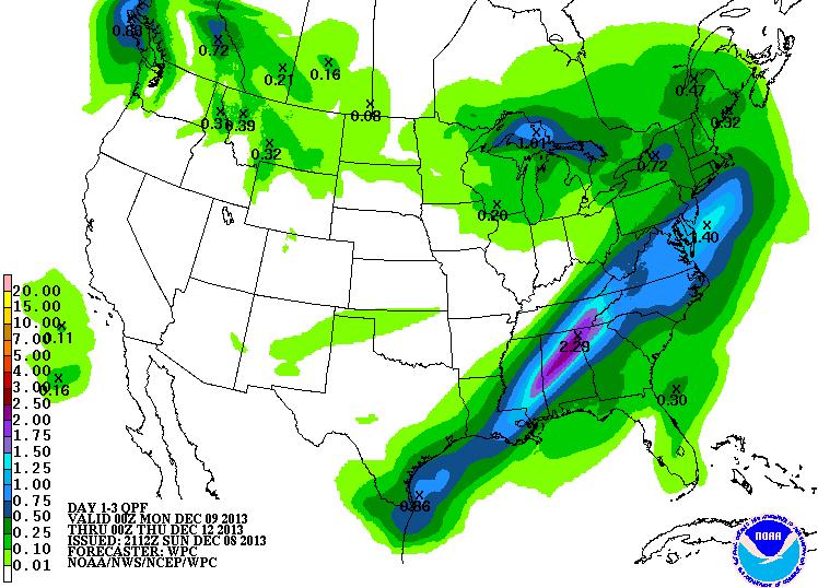
Precipitation Outlook
According to NOAA, the precipitation forecast from PM Sunday to PM Wednesday looks like this. Again, our fading winter storm in the eastern part of the country will still have some lingering effects into early Monday in the eastern third of the country along heavier rain beginning to fade in the Southeast. The next weak clipper system only brings a little bit of precipitation along the northern tier of the nation, which will be in the form of light snow.
Cold Continues...
I thought it was only a figure of speech too. Huh.
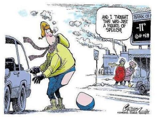
Cold Continues...
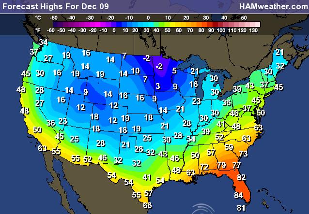
We haven't quite kicked the cold yet. It still feels a lot like mid January with temperatures running well below the norm. Here's a look at expected highs for Monday across the nation. Note that some near in the Upper Mississippi Valley may note even get out of the subzero range on Monday!
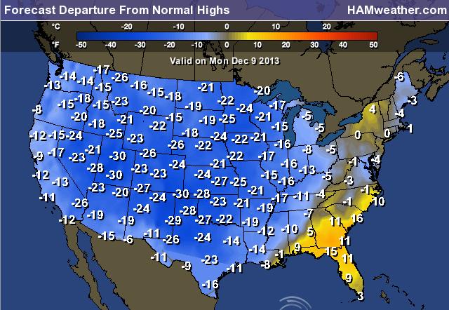
Highs From Normal Monday
Much of the nation on Monday will still be well below average and most in the double digits below average!
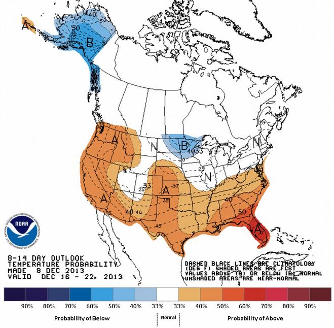
Light at the End of the Tunnel?
According to NOAA, the mid December temperature outlook looks pretty good. Some of us may actually get a chance to thaw out just before Christmas!
Thanks for checking in, have a great week ahead!
Don't forget to follow me on Twitter @TNelsonWNTV

See more from TheEpocTimes.com HERE:
(Photo courtesy: WI DOT)
U.S. Snow Cover
This is an impressive map for early December! As of Sunday, 58.5% of the nation was covered in snow! In fact, I don't recal seeing this much snow cover across the nation this early in the season in quite a while!
U.S. Snow Cover Last Year: 2012
As of last year, only 18.3% of the nation was covered in snow.
Weather Outlook Thru Early Week
Our wild winter weather scenarios will begin to wind down across the nation thru early week. Monday will still harbor some lingering effects along the eastern part of the country as the low tracks north along the East Coast. By Tuesday, most of the wild weather in the eastern part of the country will be fading, but a weak clipper system will flirt with the international border Monday/Tuesday and kick out a little snow.
Snow Potential
Plowable snows will still be ongoing across parts of the northern New England States, but the wintry mess that most encountered on Sunday will turn to a cold rain farther south. Note the thin band of snow potential from New Mexico to the Ohio Valley thru AM Tuesday...
Precipitation Outlook
According to NOAA, the precipitation forecast from PM Sunday to PM Wednesday looks like this. Again, our fading winter storm in the eastern part of the country will still have some lingering effects into early Monday in the eastern third of the country along heavier rain beginning to fade in the Southeast. The next weak clipper system only brings a little bit of precipitation along the northern tier of the nation, which will be in the form of light snow.
Cold Continues...
I thought it was only a figure of speech too. Huh.
Cold Continues...
We haven't quite kicked the cold yet. It still feels a lot like mid January with temperatures running well below the norm. Here's a look at expected highs for Monday across the nation. Note that some near in the Upper Mississippi Valley may note even get out of the subzero range on Monday!
Highs From Normal Monday
Much of the nation on Monday will still be well below average and most in the double digits below average!
Light at the End of the Tunnel?
According to NOAA, the mid December temperature outlook looks pretty good. Some of us may actually get a chance to thaw out just before Christmas!
Thanks for checking in, have a great week ahead!
Don't forget to follow me on Twitter @TNelsonWNTV