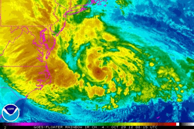
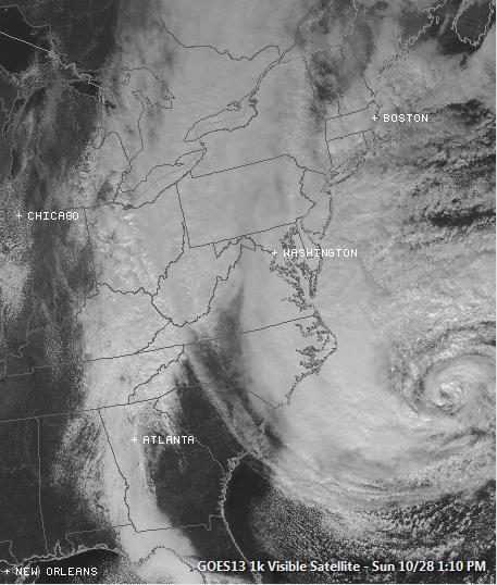
This is worth a look... this satellite loop shows the life cycle of Sandy
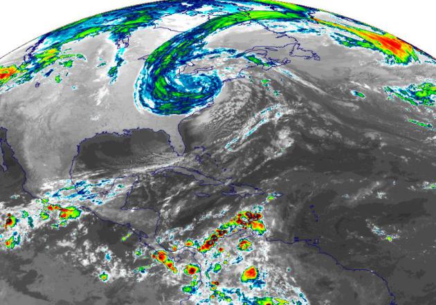
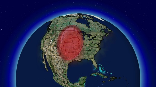
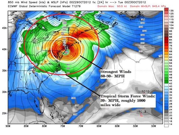
Size of Sandy – IMMENSE!
Take a look at these screen captures that
we made at the office on Tuesday. We tried to put into perspective the
overall immensity of the storm as it sat on the eastern half of the
country on Tuesday.
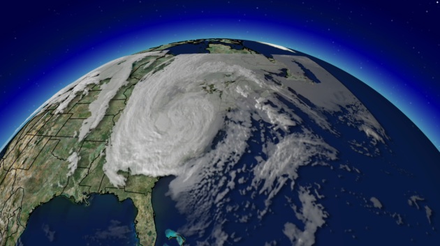
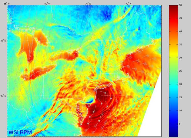
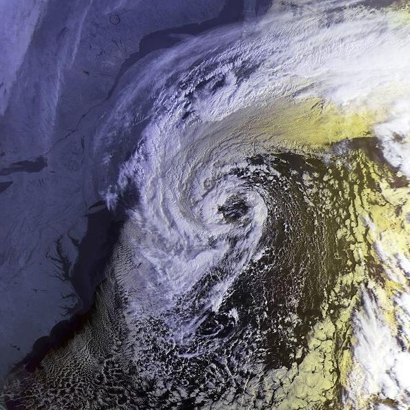
Satellite of Sandy on Tuesday
WOW… what a storm, eh? This reminds me a
lot of the satellite picture of the storm in the movie “Day After
Tomorrow”. We don’t have the satellite data of the northern side of the
storm here, but let’s just say that the cloud shield from the
Superstorm stretched from the Hudson Bay to the Gulf Coast States. The
comparison to that is in the following images below.
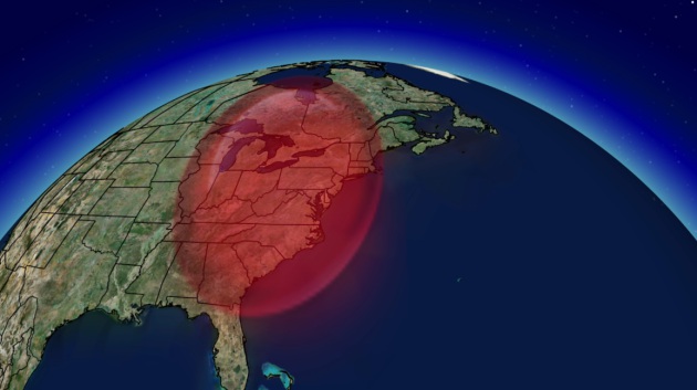
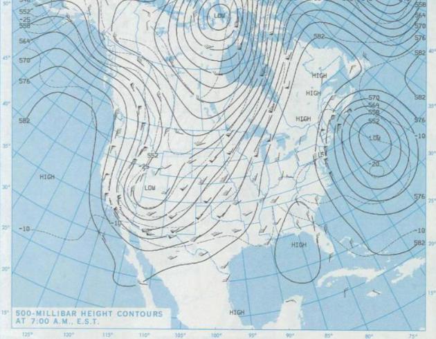
Size Marker #1
Size Marker #2
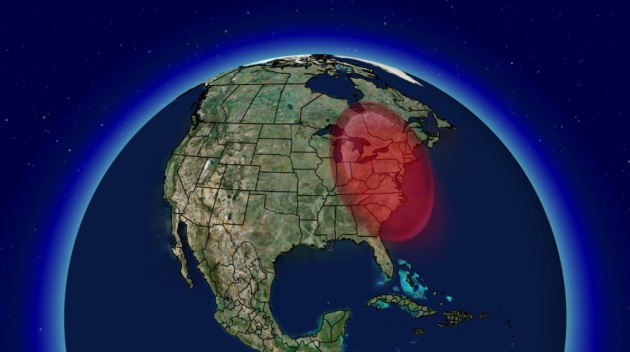
Size Marker #3
In this image, we can really see how large
this system really is. That’s approximately the distance from just
north of International Falls, MN to just north of Brownsville, TX… A
quick Google mapping driving distance to those places showed an
approximate distance of 1,800 miles.
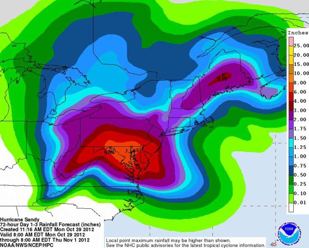
Superstorm Sandy’s Significant Impacts
Here are just a few of the major headlines that we were able to pick up… there are many more and likely many to come.
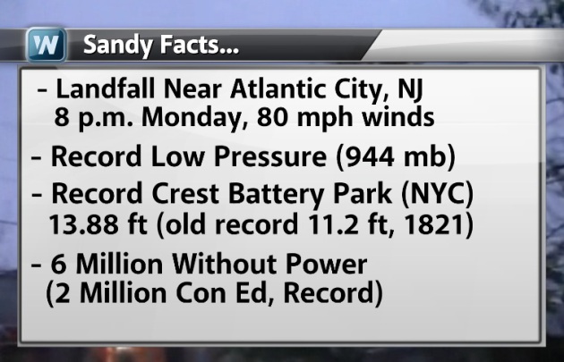
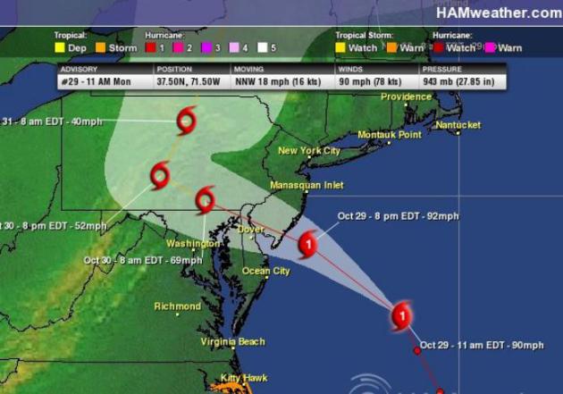
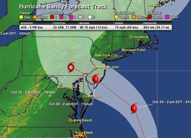
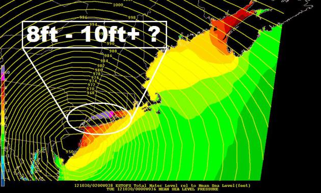
*The Landfall occurred near Atlantic City,
NJ aroun 8pm Monday with 80mph. This was the worst case scenario for
New York as it was on the “Right Front Quadrant” of the storm. This
allowed hurricane for winds to pile up water in those areas. The storm
surge growing to over 10ft. in many locations, worse than previously
thought.
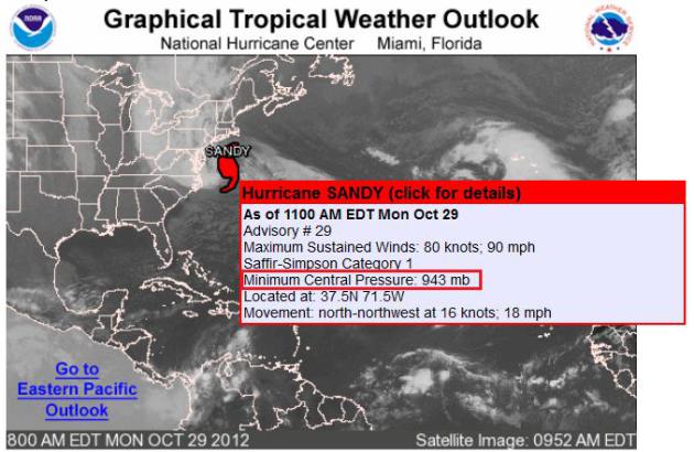
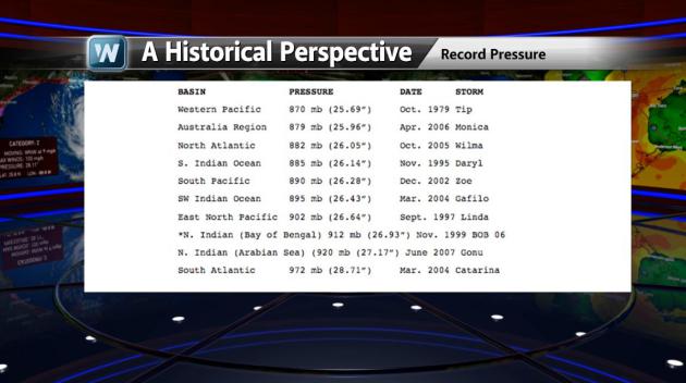
*The central pressure of the storm was that
of 944mb as it made landfall, which makes it the strongest storm of an
Atlantic Basin storm north of Cape Hatteras, NC! The information below
was from our very own Bryan Karrick.
“The Great Hurricane of Sept. 1938,
also known as the “Long Island Express,” had the lowest pressure of an
Atlantic Basin storm north of Cape Hatteras, NC at 946 mb. Hurricane
Sandy broke a record Monday, the central pressure dropped to 940 mb!
She made landfall with a pressure at 944mb, with a tropical storm wind
field close to 1000 miles across. As our own Addison Green says, “It’s
like flying from NYC to Tampa, FL!”
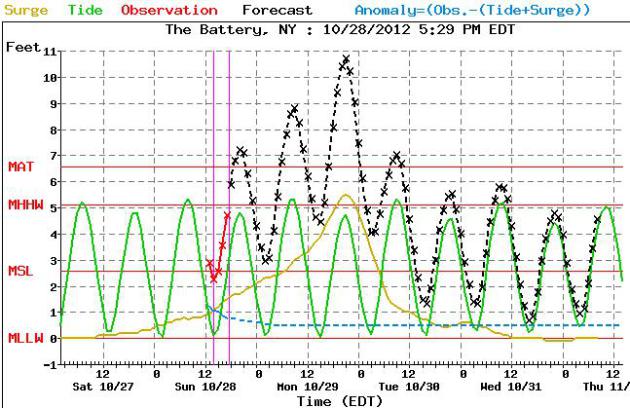
*There was a record crest at the Battery in
New York. Water levels rose to 13.88ft. overnight, which broke the
previous record of 11.2ft. set in 1821.
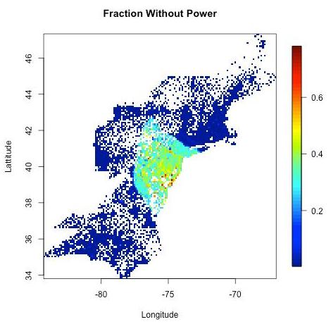
*The estimates of power outages in the
graphic below were from earlier Tuesday. That number will certainly
fluctuate significantly over time… There were reports by midday Tuesday
of nearly 7 million without power.
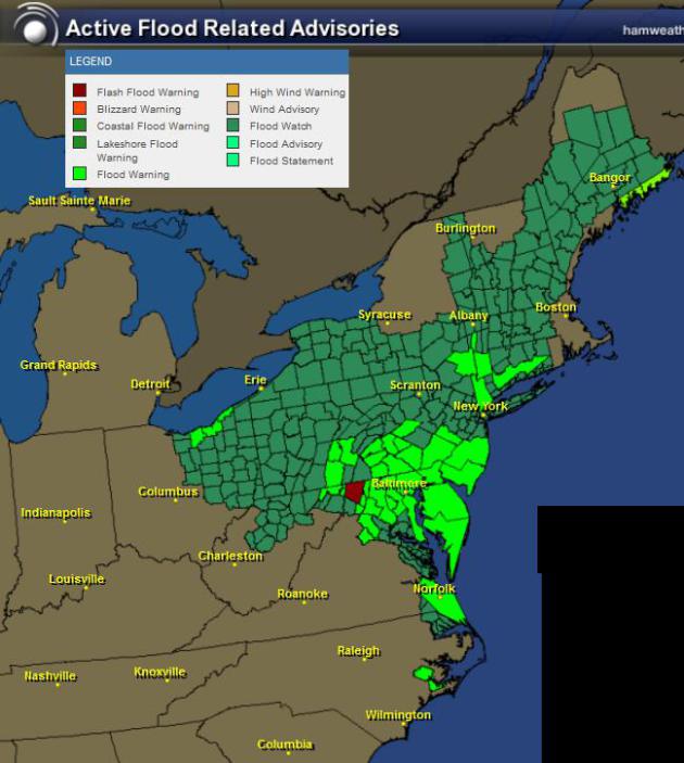
Other Significant Impacts
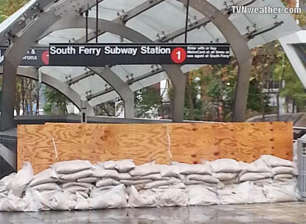
Massive flooding has over taken parts of
the city, especially in Lower Manhattan around Ground Zero. There were
also reports of subway stations filling up with water!
(Photo Courtesy: New Jersey PATH Subway System)
(Photo Below Courtesy: National Hurricane Updates)
New York AP photo, tons of yellow taxis submerged in Hoboken

Photo of the Plaza Shops in NYC

Flooding in Linden, NJ

Massive Power Outages
Take a look at this video out of New York
City. That’s an explosion at a Con Ed plant! Con Edison is the power
company out there.

Power Failure Map
This is a interesting map (check the loop here) – it shows the number of power failures throughout the evening.
“More than six million customers lost
power Monday as Hurricane Sandy felled trees, downed power lines and
flooded substations. The storm led to power failures in at least 17
states, including more than a million customers in Pennsylvania and New
Jersey and about 660,000 in New York City. Roughly a quarter million
customers lost power in Manhattan alone after a fiery explosion at a
substation on East 14th Street, leaving nearly the entire island eerily
dark south of 34th Street. Con Edison officials called the power
failures “the largest storm related outage in our history.” Officials
said they expected to be able to restore electricity to much of
Manhattan before the night was over but that it could be a week before
all service was restored.”

New York Faces Big Problems!
Here are two quotes that really put into perspective the size and magnitude of the situation.

Line for Pay Phone?
Thanks to my good friend Peter Brooks out
in New York for this picture. He snapped this picture of folks waiting
in line for a PAY PHONE! He says, "when was the last time you've ever
seen that?"

The AP summarized some of the major impacts from Sandy:
CAROLINAS
The U.S. Coast Guard rescued 14 members of a crew forced to abandon a tall ship off the North Carolina coast, but two other crew members were still missing. The HMS Bounty was originally built for the 1962 film “Mutiny on the Bounty” starring Marlon Brando and has been featured in other films, including one of the “Pirates of the Caribbean” movies.
CONNECTICUT
The University of Connecticut is closing Tuesday, joining a hundreds of other schools and school systems across the state. The closure includes UConn’s law school and the UConn Health Center, though the John Dempsey Hospital will remain open during the storm. Power outages: 117,400.
DELAWARE
Dover Air Force Base has relocated some aircraft in anticipation of the storm, and the Federal Emergency Management Agency has requested that the base be used as a staging area for support and supplies. Some residents of low-lying areas of the base have been ordered to evacuate. Power outages: 1,800.
ILLINOIS
The powerful storm is expected to extend as far as Chicago, where the National Weather Service already has issued high wind warnings and a lakeshore flood warning for Tuesday and Wednesday. Water may pile up on the south shore of Lake Michigan, said Louis Uccellini, director of environmental prediction for the National Oceanic and Atmospheric Administration.
KENTUCKY
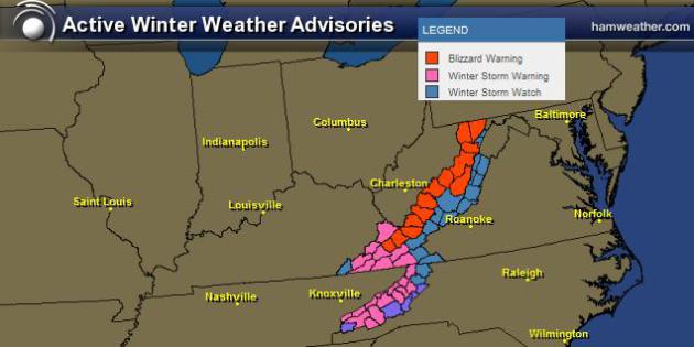
Sandy is expected to bring snow to far southeastern Kentucky. A winter storm warning is in effect in Harlan, Letcher and Pike counties through Wednesday morning. Forecasters say snow could accumulate from 4 to 10 inches in high elevations and 1 to 3 inches in lower elevations.
MAINE
Virtually all Maine public schools opened Monday but some were closing early before the heaviest rain and wind from Hurricane Sandy. State officials say the biggest concern is wind, which is expected to cause widespread power outages. The state’s utilities say they have crews poised to deal with expected power outages, including some from Canada. Power outages: 26,000.
MARYLAND
Baltimore Mayor Stephanie Rawlings-Blake says vehicular travel is banned on city roads beginning at 6 p.m. Monday. The restrictions to do not apply to uniformed personnel, hospital employees or other medical providers. Gov. Martin O’Malley earlier Monday closed the Bay Bridge.
MASSACHUSETTS
Voluntary evacuation recommendations have been issued in Scituate, Lynn, New Bedford and Plum Island. The recommendations are for just certain sections of the communities that could be affected by flooding as a result of Hurricane Sandy. A Red Cross spokeswoman said just a few people stayed at its shelters Sunday night, but she expects more people Monday night and into Tuesday. Power outages: 222,000.
MICHIGAN
Michigan utilities say high winds could cause power outages in the state and they’re keeping an eye on the weather to respond to power problems. DTE Energy Co. said gusts of 50 mph Monday evening and Tuesday could affect some it its 2.1 million customers.
NEW HAMPSHIRE
Gov. John Lynch has urged all drivers to be off the roads by 3 p.m. as Hurricane Sandy approaches. Lynch declared a state of emergency and directed that non-essential state workers be released from work Monday afternoon. He urged employers to consider releasing workers early. The governor has put 100 New Hampshire Guard soldiers on active duty. Power outages: 99,000.
NEW JERSEY
All roads into and out of Ocean City are closed due to flooding that has cut off the popular Jersey shore resort community. Hurricane Sandy already had flooded most of Atlantic City, sweeping away an old section of the city’s famed boardwalk. Power outages: 434,000.
NEW YORK
A construction crane atop a luxury high-rise collapsed in high winds Monday and dangled precariously midtown Manhattan. Some buildings were being evacuated as a precaution and the streets below were cleared, but there were no immediate reports of injuries. Power outages: 451,967.
OHIO
Residents of low-lying areas and along Lake Erie were told to watch for flooding; utilities are anticipating high winds that could blow down trees and poles. Snow is forecast in some areas.
PENNSYLVANIA
Officials from the state transit agency and the Pennsylvania Turnpike have instituted speed restrictions over concerns about high winds and ordered certain vehicles, including empty trucks and motorcycles, off some highways. The National Weather Service says southeastern Pennsylvania could get winds reaching 75 mph and rainfall up to 10 inches. Power outages: 74,000.
RHODE ISLAND
Officials are concerned about wind driving water north up Narragansett Bay, which could create flooding in low-lying areas of the upper bay, including Providence, Warwick and Cranston. About 2,600 National Grid customers were without power, mostly in Barrington and other parts of Bristol County. Power outages: 80,000.
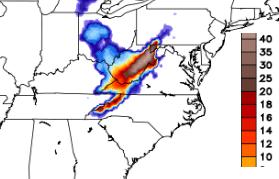
TENNESSEE
Snow is expected in higher elevations, where a freeze warning has been issued. High winds are expected in many areas.
VERMONT
Gov. Peter Shumlin declared a state of emergency to provide access to National Guard troops in a state still recovering from the devastating effects of the remnants of Hurricane Irene. Culverts and storm drainage basins in some spots have been cleared of debris. Power outages: 13,170.
Early Estimated Losses From Sandy…
Some of the early estimates suggests that
the estimated losses from the storm (this number is frightening) could
total $45 BILLION dollars!

Late Night in New York
I thought this was interesting… Jimmy
Fallon, late night talk show host sent his audience home before the
show started/the storm hit and for good reason. However, Jimmy still
did the show!

Major Wind Gusts
Take a look a few of the higher wind gusts
reported across the area yesterday. The highest on the list compiled
by the NWS was a 94mph report Eatons Neck, NY. There was another
notable report from the Islip Airport at 90mph

Mount Washington Observatory
There were even stronger wind gust reports
coming from Mount Washington Observatory in New Hampshire (elevation
6,288ft.). There were several gusts over 100mph, but the strongest
report was 140mph!
“The official wind chart for October
29, 2012 – peak gust of 140 mph (139.7 mph to be specific)! This is the
24 hour Hays (wind speed recording device) chart with average wind
direction and speeds recorded around the edge of the chart. Midnight is
at the top then it goes hourly counterclockwise. The peak is marked by
the triangle. Time, speed in KTS, and gust direction are in the center.
FYI – this is the strongest recorded gust since March 21, 2008 when
145 mph was measured. Additional Max, Min, Avg weather data for
yesterday (and all of October) can be viewed here:
http://www.mountwashington.org/weather/f6/2012/10.pdf”

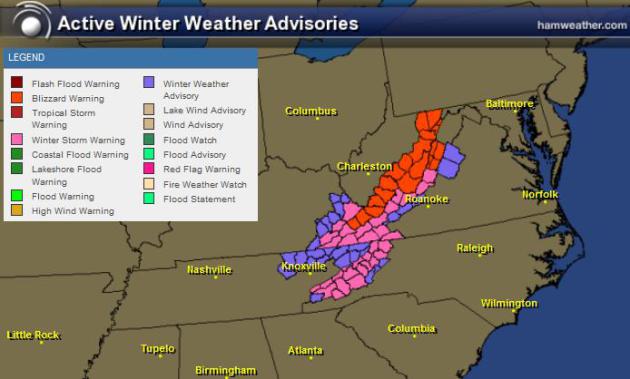
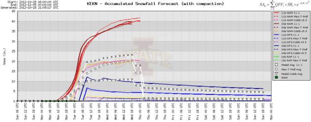
Massive Snows in the Appalachians!
Thanks to Beau Dodson for this picture out
of Davis, WV! That’s insane and one massive dumping of snow in the
Appalachians. The snow will be measured in feet!
“There is a car under the snow – this
is a side street. This is about 2 blocks east of the main street here
in Davis, West Virginia – the downtown street.”


I could honestly keep going with
information… there is SO much! Thanks for checking in on this Tuesday,
have a great rest of your week. We’ll have more tomorrow!
Don’t forget to follow me on Twitter @TNelsonWNTV


