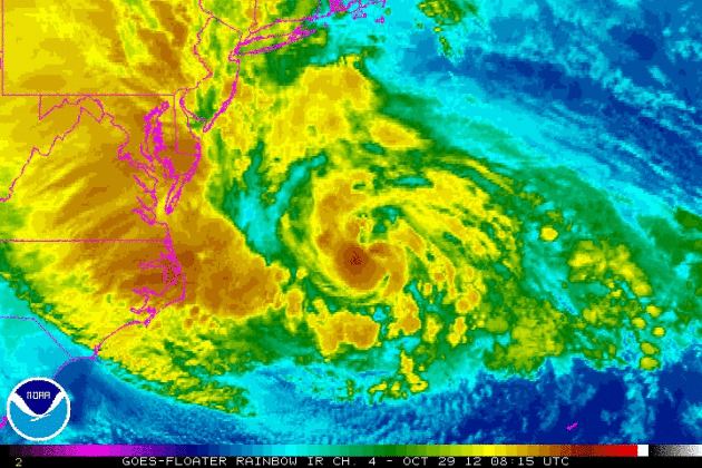
Summary: The (super) storm we’ve been tracking and
warning of for nearly a week is now approaching. Final contingency plans
should be rushed to completion. The height of the storm comes tonight,
but the first (major) storm surge arrives late morning and midday,
starting with the New Jersey coastline. The storm is tracking (very)
slight farther south of New York City than models were suggesting
yesterday, but our team still expects a major storm surge for Long
Island Sound, inundating low-lying areas of Brooklyn and Queens
(including some of the runways at JFK and LGA). Lower Manhattan will see
substantial flooding at high tide, later this morning, again late
evening. Inland rains will create flash flooding capable of shutting
down even major highways, but rainfall amounts won’t be quite as severe
from New York to Boston. It’s hunker-down time, venturing outside to
drive (or shoot video/photos) a fairly bad idea from D.C. to Boston
today.
Some level of property damage in high impact areas is inevitable –
right now the priority is lowering the risk to staff in the path of
Sandy. If team members living within 10 feet of water can’t evacuate
inland, or to higher ground, the next best option is a vertical
evacuation, riding out the storm in a 3rd or 4th floor building.
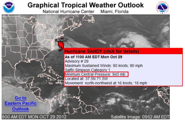
Worst Case Scenario Unfolding
If you recall last week, we were talking
about the worst case scenario that would unfold if this storm were to
make a landfall in the Northeast, more specifically just south of Long
Island. As Sandy started to interact and merge with the cold air mass
over the Northeast, it intensified even further than previously
thought! The 11am update from the National Hurricane center actually
had the central pressure of the storm at 943mb (sustained winds of
90mph with higher gusts)… to put that into perspective, the central
pressure of “The Perfect Storm” back in 1991 was that of a 972mb low,
which actually stayed offshore!
Sandy: Record Setting Superstorm?
Thanks to WeatherNation Meteorologist Todd Nelson for the info below:
“The Great Hurricane of Sept. 1938,
also known as the “Long Island Express,” had the lowest pressure of an
Atlantic Basin storm north of Cape Hatteras, NC at 946 mb. Hurricane
Sandy broke that record this morning, dropping to 943 mb! She is
forecast to make landfall with a pressure between 944-952 mb, with a
tropical storm wind field close to 1000 miles across. As our own Addison
Green says, “It’s like flying from NYC to Tampa, FL!”
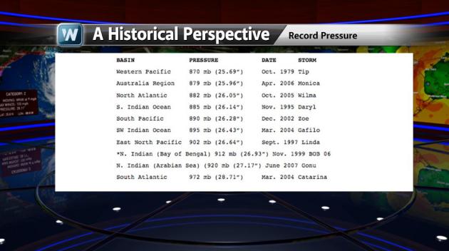
Other Historical Low Pressure Records…
This may also help to put into
perspective how strong this storm may be. Note that the lowest pressure
ever recorded in the Atlantic Basin was that of Wilma at 882mb in Oct.
2005.
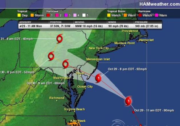
Sandy Landfall PM Monday
The 11AM Monday update from the National Hurricane Center had the storm as a CATEGORY 1 storm just prior to landfall.
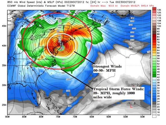
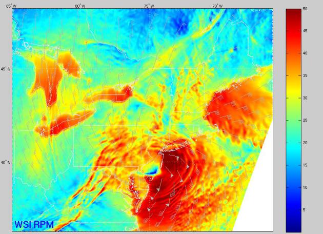
RPM Model of Winds at Landfall
I thought this was an incredible map!
Take a look at the significant wind field that showed up on previous
model runs as Sandy was running ashore. The blue coloring over southern
New Jersey would indicate the calm nature of the winds near the “Eye”.
Note also the easterly fetch to the winds on the northerly side of the
eye, this would indicate a worse case scenario for New York , Long
Island and surrounding areas in terms of wind and storm surge.
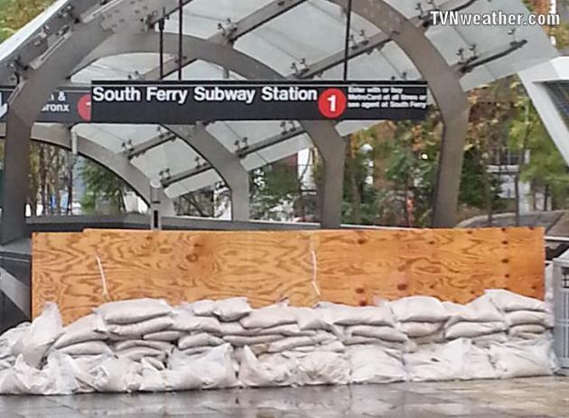
An Eerie Sight in NYC
How about this… kind of an eerie sight
out of NYC as the subways system was shut down on Monday! Thanks to
TVNweather.com for the images below.

NYSE Closes for First Time in 11 Years
Here’s another crazy sight from the NYSE, which was closed today for the first time in 11 years!
“U.S. stock markets are closed as
Hurricane Sandy nears landfall on the East Coast and are likely to
remain closed Tuesday. The last time the New York Stock Exchange had an
unplanned closing since the terrorist attacks of September 2001. (Oct.
29)”

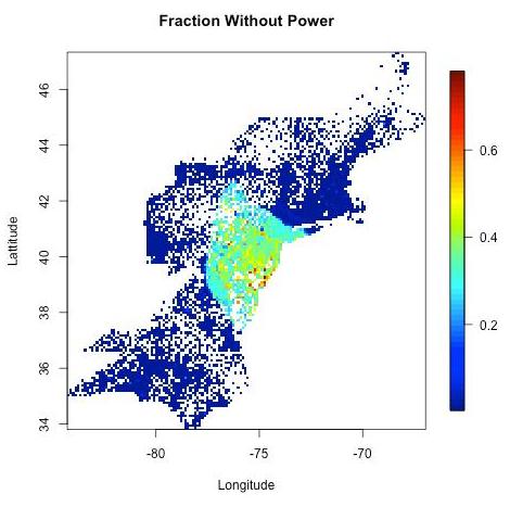
Expected Power Outages… in the Millions?
An 18th Century Tuesday For Millions of Americans?
An engineer at John Hopkins University has predicted power outages,
based on Sandy’s characteristics and track. Here is an excerpt of his
study: “Using a computer model based on a current forecast as well as
data from past hurricanes, an engineer at The Johns Hopkins University
predicts that 3 million people in New Jersey will lose power during
Hurricane Sandy. Pennsylvania will follow closely behind with 2.5 to 3
million people predicted to lose power, and Maryland with 1.8 million
people predicted to lose power. Washington, D.C., and Delaware will have
fewer outages, with 200,000 and 400,000 people predicted to lose
power, respectively.”
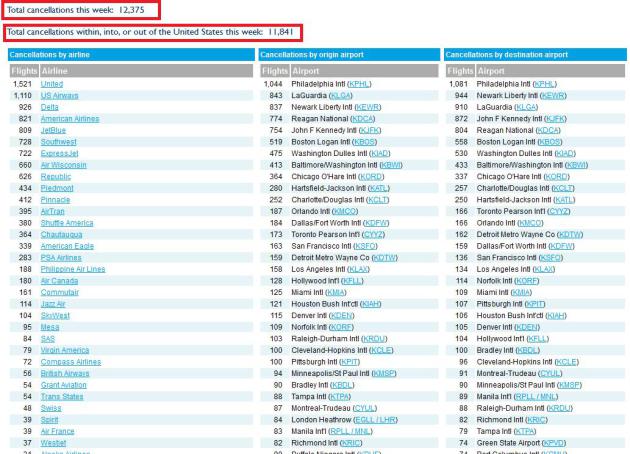
Significant Travel Headaches
WOW! Sandy is having a major impact on
air travel across the country and flights inbound and outbound have
been cancelled at most of the major hubs out east. According to
FlightAware.com there have been more than 12,000 flights cancelled
likely due to Sandy.
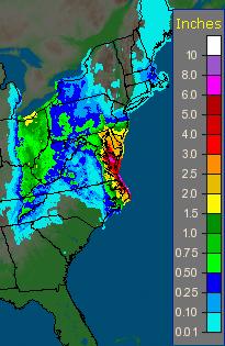
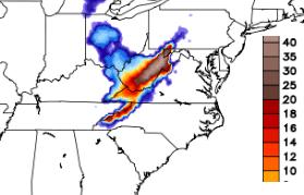
Significant & Record Setting Rainfall… More to Come
I can’t get over the magnitude of this
situation. From heavy winds, storm surge and significant beach erosion
to coastal and inland flooding to heavy snows in the Appalachians. It
really is hard to keep up with everything that is going on, again due to
the magnitude of the situation. That’s why it is so important to
follow your local government agencies when it comes to warnings and
advisories regarding the weather and or potential
emergencies/evacuations. One of the concerns (flooding) has already
taken place in many locations along the Eastern Seaboard with more to
come. The image below shows the rainfall associated with Sandy since
yesterday.
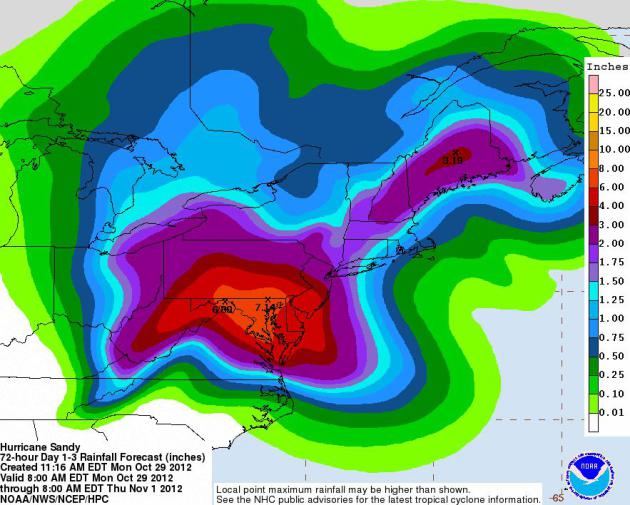
Additional/EXTREME Rainfall
Take a look at NOAA’s HPC 3 day
precipitation forecast over the Northeast. Some locations could pick up
an additional 6″ to 7″ of precipitation or more, which is cause for
concern in terms of significant inland flooding. It’s also interesting
to note that some of this extreme precipitation will be falling in the
form of snow across the higher elevations of the Appalachians.
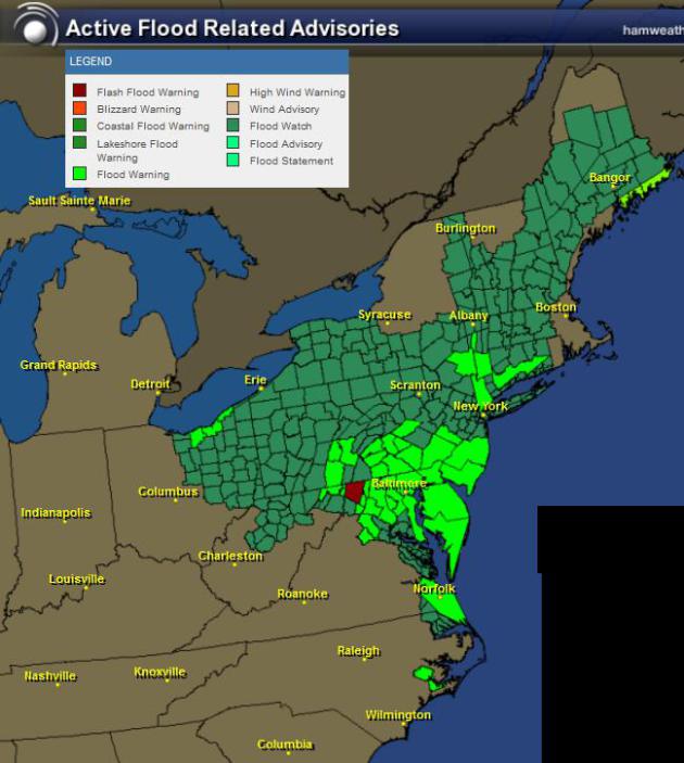
Active Flood Headlines
These are all of the active flood
headlines across the area as Sandy spreads moisture inland through the
next few days. Check your local NWS forecast office for a more specific
update on localized hazards due to the extreme rainfall expected.
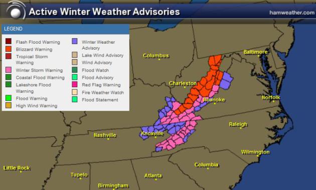
Active Winter Weather Headlines
These are the winter weather headlines
that the National Weather Service has issued for the higher elevations
of the Appalachians. Significant snow and high winds could create
blizzard like conditions for areas shaded in red.
Snow Forecast
Latest forecasts for snow looks extreme
by all measures! There will be 1ft. to 2ft. amounts, but I won’t be
surprised to hear reports of 3ft. or more!
Thanks for checking in on this Monday, have a great rest of your week!
Don’t forget to follow me on Twitter @TNelsonWNTV