 Rare October Severe Outbreak?
Many locations do see a (small) second severe weather maxima in
September and October, as colder Canadian air pushes south, setting up
the strong temperature contrasts (and wind shear environment aloft)
to
support isolated severe storms. The Southern Plains may see severe
weather later today, spreading into Iowa and southern Wisconsin by
Saturday. With the storm tracking well south/east of MSP right now I do
not expect severe weather across Minnesota. Maps above:
NOAA SPC.
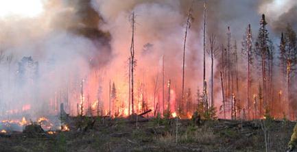
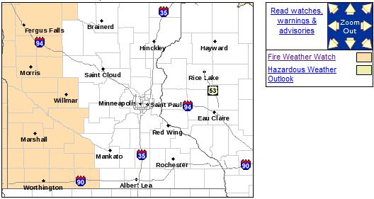
 Fire Weather Watch
 posted for the western third of Minnesota today. Photo: Minnesota DNR.
.05" latest prediction for Saturday rainfall in the Twin Cities (00z NAM model).
6 out of the first 11 days of October have seen at least a trace of snow in Duluth.
1" of snow so far in Duluth, about 1/2" above average. Source: Timothy Burr.
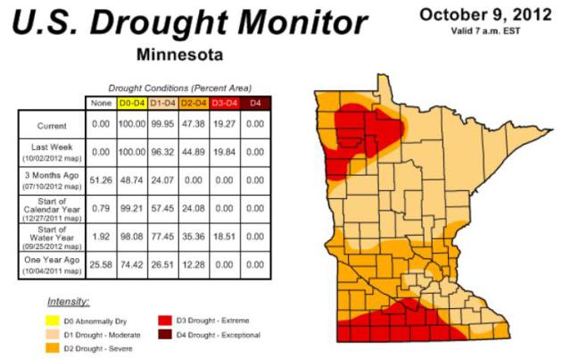
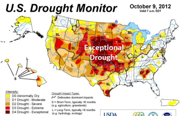
99.95% of Minnesota in Moderate Drought. To put that
number into perspective, on August 9 only 24% of the state was in a
moderate drought, now nearly the entire state is suffering through a
deepening moisture deficit. The area of severe drought (47%) has gone up
slightly in the last week, the area impacted by extreme drought
(19.27%) holding nearly steady. Map:
U.S. Drought Monitor.
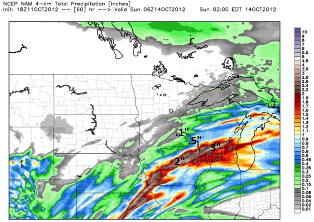
Another Near-Miss. The computer models giveth - they
also taketh away. And yes, I'm as disappointed as everyone else. The
latest 4 km. NAM model run shows some 1-2" amounts over Iowa and
southern Wisconsin, closer to .1 to .2" for the metro, closer to .50"
for Winona and La Crosse.
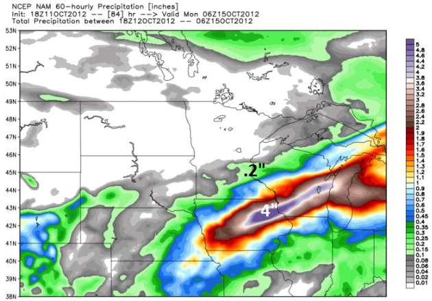
General Model Agreement. The 12 km. NAM shows even
more impressive rainfall amounts Saturday into Sunday, some 2-4" amounts
from near Des Moines and Waterloo into southern and central Wisconsin.
Bottom line: we'll be lucky to see .1 to .3" rain in the Twin Cities,
with heavier amounts over far southeastern Minnesota.
 Fire Weather Watch
.
Here's another symptom of how dry it is out there - another Fire
Weather Watch posted for much of western Minnesota again today. Details
from the Twin Cities NWS:
...FIRE WEATHER WATCH FRIDAY AFTERNOON FOR PARTS OF WEST CENTRAL
AND SOUTH CENTRAL MINNESOTA FOR LOW HUMIDITY AND STRONG WINDS...

.DANGEROUS FIRE WEATHER CONDITIONS ARE POSSIBLE FRIDAY AFTERNOON
ACROSS PARTS OF WEST CENTRAL AND SOUTH CENTRAL MINNESOTA ON
FRIDAY AFTERNOON...AS STRONG SOUTHERLY WINDS COMBINE WITH LOW
HUMIDITY VALUES AND DRY CONDITIONS. A FIRE WEATHER WATCH HAS BEEN
ISSUED GENERALLY WEST OF A LINE FROM ALEXANDRIA...TO WILLMAR...TO
NEW ULM...TO FAIRMONT FOR FRIDAY AFTERNOON.

SOUTHERLY WINDS OF AT LEAST 20 MPH ARE EXPECTED TO DEVELOP BY
NOON ON FRIDAY...AS A LOW PRESSURE SYSTEM APPROACHES FROM THE
WEST. AS TEMPERATURES GRADUALLY WARM THROUGHOUT THE DAY...
RELATIVE HUMIDITY VALUES SHOULD ALSO DROP INTO THE 20 TO
25 PERCENT RANGE DURING THE AFTERNOON.
"...
I plead guilty to tunnel vision around climate," McKibben
said. "It's the biggest issue the planet has ever faced, and in 50
years the one thing we will be interested in knowing is how our leaders
responded to it -- or didn't. I mean, the Arctic broke this summer,
and we had the hottest month in American history," he added. "So it's
perhaps just possible the Obama administration hasn't done quite enough..." - Bill McKibbon, in a Huffington Post article below.
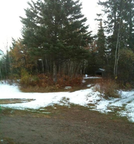
Hibbing Slush. Sydney Drennan snapped this photo
Thursday morning, showing a cool half inch of snow on fields and lawns
in the Hibbing area. It was gone by afternoon as the sun peeked out, but
signs of winter-to-come are everywhere.
National Numbers. 63% of the USA is in moderate
drought, 39% experiencing severe drought, the 20% of the USA enduring
extreme/exceptional drought is holding nearly steady. Map:
U.S. Drought Monitor.
Hop! Suitcase Automatically Follows Its Users. My prayers have been answered, because keeping track of my luggage is a full-time job.
Gizmag.com has the (slightly bizarre) details: "
As
any frequent flyer knows, hauling around a passport, carry-on luggage
and suitcase while navigating through an airport can be a real hassle,
and the situation is made worse if the traveler in question has any
physical health issues. Madrid-based designer Rodrigo Garcia Gonzalez
has come up with an ingenious solution to this issue: a smart carry-on
suitcase named Hop! which follows the traveler around automatically..."
Detroit's WDIV Follows Saga Of Raccoon With Jar Stuck On Its Head (Video). Proving it's a relatively slow news cycle, at least one broadcaster in Detroit has lightened up the mood a bit;
TVSpy.com reports: "
Last night during the 11 p.m. news WDIV, Detroit’s NBC affiliate began tracking the case of a raccoon with what looked like a mason jar stuck on its head. The raccoon had climbed to the top of a utility pole in Southfield, a Detroit suburb, where WDIV’s “Nightcam” (reporter/cameraman Tim Pamplin)
caught up to it. “Look up there that poor little thing,” said Pamplin
who was live at the scene. “Its a raccoon with a, what looks like a
plastic container on his head. He’s been doing everything he can to get
it off all day long. But to no avail.”
Definition Of "Spotty Shower". Migizi Gichigumi
snapped this photo in Ashland, Wisconsin Thursday - a fast-moving
clipper sparking a few isolated showers of rain (mixed with wet snow
from the MN Arrowhead into the U.P. of Michigan).
* photo above courtesy of Renee Schneider.
Thankful
“An attitude of gratitude flavors everything you
do. Learning to be thankful is the golden thread woven through every
truly successful life” wrote Charlie Jones.
I agree.
Every day I give thanks for living in a clean,
progressive state, where people still care about their work, and their
neighbors. No earthquakes, volcanoes or storms with names either. That
makes our blustery clippers easier to stomach.
That old adage, "when in a drought, don't
predict rain" rings true. We all got our hopes up for a real rain event
Saturday, but latest models whisk the heaviest, steadiest rains south
and east of Minnesota. Par for the course. We may still pick up a little
rain, but right now it doesn't look like the long, cool soaking we
need. As long as dry, westerly winds dominate our weather pattern wet,
moisture-lade Gulf storms will continue to take a southerly detour.
The latest Drought Monitor shows 99 percent of
Minnesota in moderate drought, 47 percent in a severe drought. Let it
rain. Please.
We're in a manic, confusing pattern. The simple
act of getting dressed every morning has become a bit baffling. A freeze
this morning gives way to 2 days of 60s early next week.
Hints of Indian Summer.
Climate Stories...
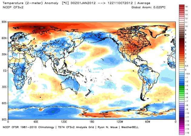
2012 Year To Date Temperature Anomalies.
Temperatures over much of North America are 1-3 C warmer than the
1981-2010 average, but look at anomalies north of Russia/Siberia, as
much as 7 C (12 F.) warmer than the rolling 30 year average. I don't
think I've ever seen yearly anomalies this extreme. Graphic:
NOAA NCEP and WeatherBell.
Bill McKibbon Talks Climate Change With Bill Maher (Video). Treehugger.com has the clip with McKibbon; here's an excerpt of an accompanying story: "
David Roberts posted
this video of Bill McKibben's spot on Bill Maher's HBO show, and it is
indeed one of the best climate segments I've seen on TV for quite some
time. McKibben is eloquent and lucid as ever — though you can tell
he's a bit ill at ease in a room full of knee-slapping pundits — and
the segment never lags over its 12-minute running time. It's a good
chance to catch up on the most recent developments on the climate front,
and their current relation to political and pop culture..."
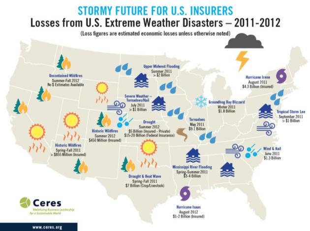
Climate-Proofing The Insurance Industry.
Forbes has the story - here's an excerpt: "
The
world’s largest reinsurer has examined the recent rise in the number
and severity of natural disasters worldwide, and finds the trend bears
the unmistakable fingerprints of climate change. What’s more, America is
bearing the brunt of that change. “North America is the continent with
the largest increases in disasters,” Munich Re’s Peter Hoppe told USA Today yesterday. Take a look at the map
of the most costly extreme weather events in 2011 and so far in 2012
for a snapshot that begins to show what he’s talking about..."
* map above from
ceres.org.
Climate Science And Science Literacy: The Strange Divergence. This article at
Huffington Post
does a good job highlighting the strange disconnect; how some people
process information that doesn't quite agree with their worldview.
That's why I ask people if they're truly open to new data, new facts,
changes on the ground? The answer to that question will determine if
someone is set in their ways, capable of cherry-picking the data that
supports their position, or able to change their mind based on data.
Here's an excerpt: "
When it comes to climate, "just the facts,
ma'am" doesn't seem to cut it for some. One big puzzle for climate
scientists: despite ever-growing scientific evidence that the climate
is changing and that the change is largely due to human activities (see
here and here), a significant fraction of the American public remains unconvinced.
What's to be done? Well, if you're a scientist, the answer is obvious
-- provide the unconvinced with more evidence, more data, and surely
they will come around. Problem is, scientists continue to do just that
and continue to make little or no progress or, worse, lose ground. (See here and here.) Two studies -- one
by Lawrence Hamilton of the University of New Hampshire published last
week in the journal Weather, Climate and Society and the other
by Dan Kahan of Yale University and colleagues published in the journal
Nature Climate Change in May -- provide an explanation: for some, it
appears, personal beliefs and cultural associations trump scientific
facts...."
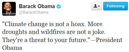
Barack Obama's Record On Addressing Climate Change Under Scrutiny By Activists. Here's an excerpt of a story at
Huffington Post: "
I think I missed the part where they discussed the Arctic melting," the environmentalist and author Bill McKibben recently quipped.
A tireless spokesman for a planet in rapid and, as he sees it,
dangerous flux, McKibben had taken to his Twitter account in the
aftermath of last week's presidential debate and, like many other
Americans, he found the whole affair wanting -- though his reasons were
singular. "Wasn't there some kind of drought or something this summer?"
he continued.
"Maybe I'm misremembering." In the clipped and sardonic vernacular of
the medium, he ended his Tweets "#oh-that." McKibben was, of course,
referring to climate change. His exasperation echoes a wider movement
that by now has grown not just weary, but vaguely astounded at the lack
of high-level dialogue on a topic that, as they see it, fundamentally
influences -- and therefore ought to trump -- all others, particularly
at a time when the nation is preparing to elect a president..."
@BarackObama Tweets On Climate Change: Yeah and Sigh... Here's a follow-up on why climate change and politics (apparently) don't mix, at least not this election cycle, from
getenergysmartnow.com: "...
Sadly, “climate change” has not (yet…) emerged as a major element of the Presidential campaign (and climate was absent from the first debate) even though it is an arena of incredibly stark difference between the candidates (and their parties) and the polling research is showing — quite clearly and strongly — that this is a winning issue for the Obama-Biden team to embrace. In short, discussing climate change issues forcefully
- Will motivate ‘the base’ to go out and vote.
- Speaks strongly to and sways ‘independents’ who resemble
Democratic voters, much more than Republicans, when it comes to
climate-change issues.
- Is irrelevant for the climate-deniers, who are already impassioned to vote for fossil-foolish politicians."
Water In A Climate Change World. I've said it
before, I'll say it again: Minnesota will be a net-winner in a warmer,
drier, stormier climate to come - some would say it's already here. Oil
isn't our #1 natural resource. It's water, and Minnesota has been
blessed with fresh water. Most computer models show a trend toward
wetter conditions over eastern Minnesota and Wisconsin, but drier
weather farther west. Here's a clip from
theenergycollective.com: "..
If
the water can’t be transferred, population and jobs will naturally
migrate over time from areas of water scarcity to areas of relatively
greater abundance. Wood asserted that a key to water management will be
to think more broadly about landscapes
– urban and non-urban – as potential hydrologic resources that warrant
protection. While some communities already incentivize low-impact
development and other stormwater management practices, the capacity for
water retention, runoff, and groundwater recharge associated with all
kinds of land uses and land covers (including rooftops) warrant
scrutiny. In other words, water management will need to become a
stronger driver in land-use planning..."
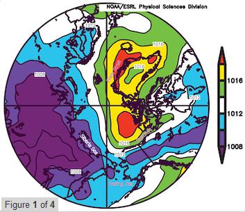
The Recent Shift In Early Summer Arctic Atmospheric Circulation.
This is a bit technical, but ice loss at the top of the world is
impacting jet stream winds over the Northern Hemisphere, as described in
this new paper at GRL,
Geophysical Research Letters: "
The
last six years (2007–2012) show a persistent change in early summer
Arctic wind patterns relative to previous decades.
The persistent pattern, which has been previously recognized as the
Arctic Dipole (AD), is characterized by relatively low
sea-level pressure over the Siberian Arctic with high pressure
over the Beaufort Sea, extending across northern North America
and over Greenland. Pressure differences peak in June.
In a search for a proximate cause for the newly persistent AD pattern,
we note that the composite 700 hPa geopotential
height field during June 2007–2012 exhibits a positive anomaly only on
the North American side of the Arctic, thus
creating the enhanced mean meridional flow across the Arctic..."
Citation: Overland, J. E., J.A. Francis, E. Hanna, and M. Wang (2012). "
The recent shift in early summer Arctic atmospheric circulation."

