
An Historic Storm
Prediction: you'll be hearing about the
implications of "Sandy" for many weeks to come. This sprawling, historic
hybrid mash-up of hurricane and fierce Nor'easter may even impact the
2012 Election.
Just a hunch.
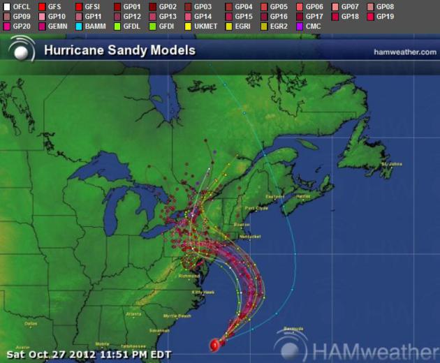
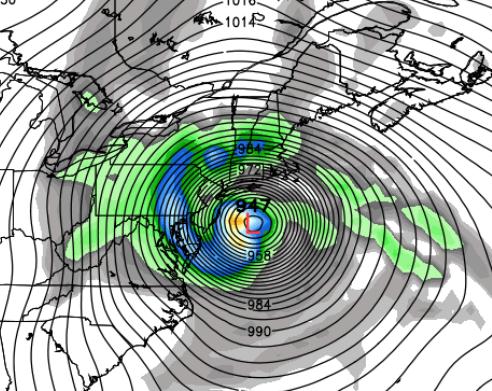
Most of the (60+) weather models we study show
Sandy pinwheeling just south of Long Island & New York City;
sustained 60-90 mph winds funneling water into the "New York Bight",
where New Jersey meets the Hudson River Valley. A full moon complicates
matters Monday afternoon, the worst day.
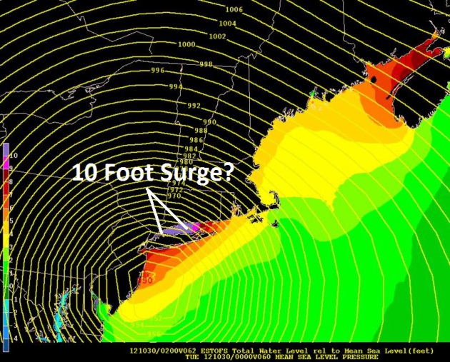
NOAA "Slosh" model simulations show an 8-9 foot
storm surge pushing across Long Island Sound into parts of Brooklyn
& Queens. Runways at La Guardia Airport may be under 2 feet of water
Monday.
In a tornado you want to be below ground, in a basement
- but hurricanes call for "vertical evacuations"; 3rd or 4th floor of a
well-constructed building. Inland flooding and week-long power outages
may impact an almost unprecedented swath of the northeast, from DC to
Philly, New York & Boston.
A quiet week is shaping up here; dry for
Halloween - 50 F. will feel surprisingly good by Thursday. A cold rain
next Monday may end as a few wet snowflakes; skies clear for Election
Day 2012.

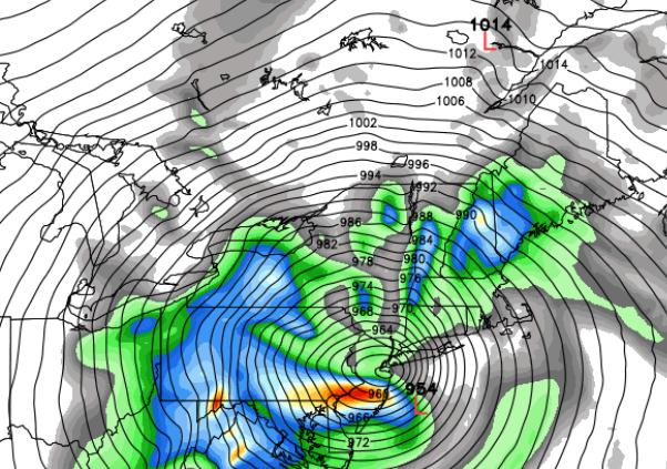
Still On Track.
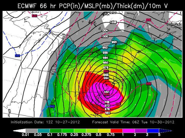
The 00z NAM shows extra-tropical Nor'easter passing very close to New
York City by 10 pm Monday night, capable of a very damaging storm surge
over Long Island and even pushing into New York Harbor, with
hurricane-force winds extending inland as far as Hartford, Albany,
Wilkes-Barre and Philadelphia Monday night.
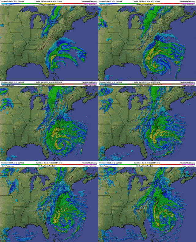
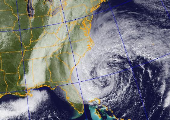
Sandy: second largest tropical
storm in the Atlantic since 1988; tropical storm-force winds extending
450 miles from the center of the storm (northeast quadrant). Source: Weather Underground. Future Radar (WRF-NMM) model courtesy of Ham Weather.
60 million Americans may be impacted by Sandy - with implications for the 2012 elections, according to the BBC.
Unprecedented? From the Saturday night Baltimore, MD/Washington D.C. NWS discussion: "I
cannot recall ever seeing model forecasts of such an expansive areal
wind field with values so high for so long a time. We are breaking new
ground here."

Monday Morning Storm Surge. NOAA models are hinting at a 5 foot storm surge Monday morning along the Jersey shore - map above valid 7 am Monday.
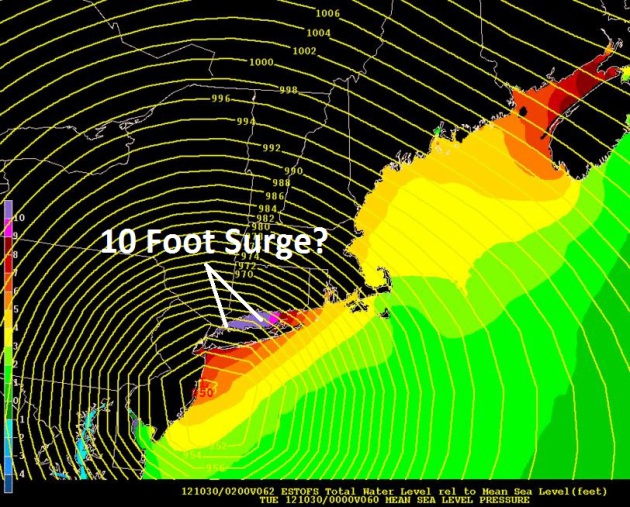
What Keeps Us Up At Night? The
same NOAA "Slosh" model is hinting at a 6-10 foot storm surge for Long
Island Sound by 7 pm Monday; the combination of sustained 60-80 mph.
winds and low pressure (and a full moon) carving out a "dome" of water,
pushed along by Sandy - water literally piling up north of Long Island -
pushing toward LGA, JFK and lowland areas of Brooklyn and Queens. Not
sure why they're not moving people.
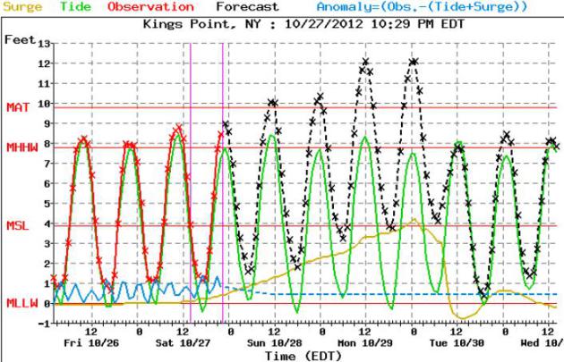
8-12 Foot Storm Surge? Here is
the NOAA forecast for Kings Point, New York, east of La Guardia Airport,
showing a steady rise in water levels, peaking Monday night - the
combination of storm surge, high tide (and full moon) creating a
possible 10+ rise in water levels in Long Island Sound.
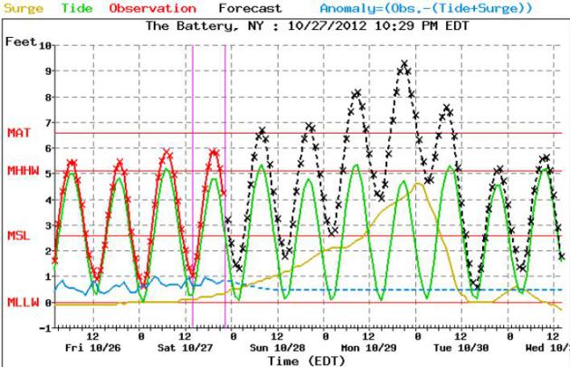
Major Flooding For Lower Manhattan? Here is the NOAA forecast
for water levels at The Battery - showing some potentially jaw-dropping
rises in water levels. A storm surge of 4-5 feet, superimposed high
tide (and full moon) may have some very unpleasant consequences for
low-lying areas of Manhattan, Brooklyn, Queens and Staten Island.

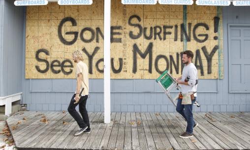
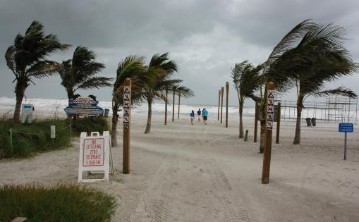
Forecast: Big Surf. Photo details: "Store
workers Fletcher Birch, right, and Jay Kleman finish boarding up the
windows on a surf store in Ocean City, Md. on Saturday, Oct. 27, 2012
as Hurricane Sandy approaches the Atlantic coast." (AP Photo/Jose Luis Magana)
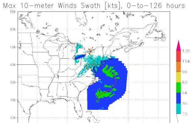
NOAA HFIP - Experimental Real-Time High Resolution Forecasts. Forecast track courtesy of NOAA AOML.
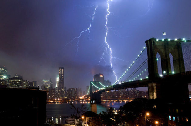
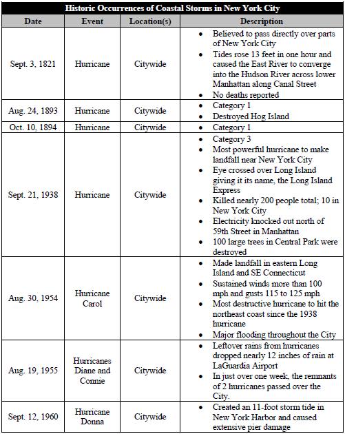
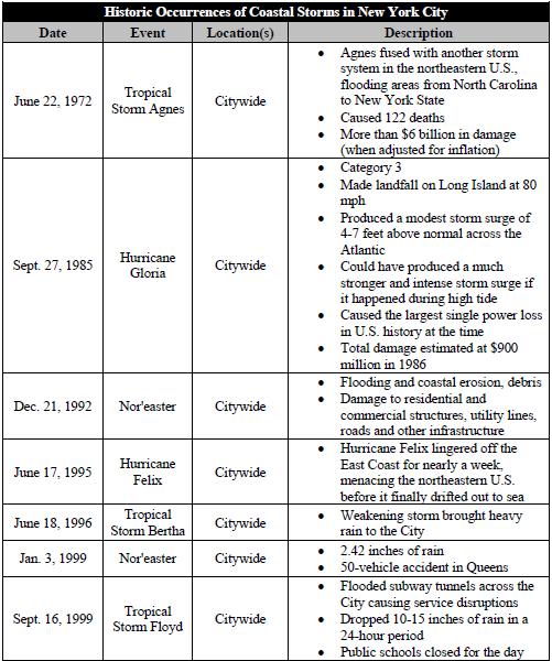
New York City's Most Destructive Storms Since 1821. File photo credit here.
- To begin preparing, you should build an emergency kit and make a family communications plan.
- Know your surroundings.
- Learn the elevation level of your property and whether the land is flood-prone. This will help you know how your property will be affected when storm surge or tidal flooding are forecasted.
- Identify levees and dams in your area and determine whether they pose a hazard to you.
- Learn community hurricane evacuation routes and how to find higher ground. Determine where you would go and how you would get there if you needed to evacuate.
- Make plans to secure your property:
- Cover all of your home’s windows. Permanent storm shutters offer the best protection for windows. A second option is to board up windows with 5/8” marine plywood, cut to fit and ready to install. Tape does not prevent windows from breaking.
- Install straps or additional clips to securely fasten your roof to the frame structure. This will reduce roof damage.
- Be sure trees and shrubs around your home are well trimmed so they are more wind resistant.
- Clear loose and clogged rain gutters and downspouts.
- Reinforce your garage doors; if wind enters a garage it can cause dangerous and expensive structural damage.
- Plan to bring in all outdoor furniture, decorations, garbage cans and anything else that is not tied down.
- Determine how and where to secure your boat.
- Install a generator for emergencies.
- If in a high-rise building, be prepared to take shelter on or below the 10th floor.
- Consider building a safe room.
Here is an edited version of what I sent our corporate Alerts Broadcaster clients Saturday PM:
* Conditions deteriorate during the day Sunday,
from south to north across the Mid-Atlantic region. Accelerate
preparations to secure facilities and safeguard staff early in the day
Sunday.
* The storm peaks Monday and Monday night;
conditions slowly improve by Tuesday afternoon as the center of Sandy
moves inland and slowly dissipates.
* New York City officials are discussing evacuation plans
and even closing the subways at the height of the storm (Monday).
“SLOSH” simulations are predicting as much as 6-9 feet of water pushing
across Long Island Sound into parts of Queens and Brooklyn. A storm
surge coming up New York Harbor may flood Lower Manhattan and Battery
Park. Areas within 5 feet of sea level are threatened. My hunch: La
Guardia Airport and JFK may see runway inundation Monday, with as much
as 1-3 feet of standing water on some runways.
* NBC in New York
reports that MTA officials are considering shutting down subways,
bridges and commuter rails by 7 pm Sunday. No final decision has been
made as of 10 pm eastern time, but I anticipate that this will, in fact,
happen. Don’t wait until the last minute.
* A 4-8 foot storm surge is possible over coastal
New Jersey and the southern coastline of Long Island. Communities that
have a history of severe flooding during hurricanes and severe
Nor’easters can expect widespread flooding from Sandy.
* Many coastal highways within 3-4 feet of sea
level will be closed by Sunday night. Again, if you plan to evacuate
away from the coast/sea level, the time to do it is now, or Sunday
morning at the latest.

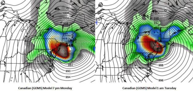
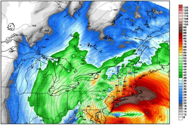
Summary: Sandy is still on track to deliver a
punishing blow to much of the northeast, the slow speed, extreme
pressure gradient and full moon on Monday making this historic
Nor’easter equivalent to a Category 1-2 hurricane. It’s still impossible
to pin down where the most severe storm surge will take place – the
level of water hinges on the precise track Sandy takes as it passes
south of Long Island and New York City Monday.
Consider accelerating your preparations to
safeguard life and property. Remember the impact of inland flooding –
many towns will lose power for several days, perhaps longer. If you live
within 5-7 feet of sea level, in an arc from New Jersey to New York to
Long Island and southern New England, have a Plan B, well inland. The
best advice if you can’t reach higher ground in time: vertical
evacuations. Find shelter on the third or fourth floor of a well
constructed building (office complex or hotel), well away from outer
walls and windows to safeguard yourself from flying debris and broken
glass.
Sandy may be a hybrid hurricane – Nor’easter by the
time it pushes ashore Monday night; but there’s little doubt this will
be an historic storm.

Remembering Irene: Don't Underestimate Risk of Inland Flooding. NOAA HPC is predicting a wide swatch of 4-8" rains from Sandy, with some 10" amounts over the Delmarva Peninsula.

* Election In Sandy's Shadow. Politico.com reports on the implications of Hurricane Sandy complicating the 2012 Election; details here.
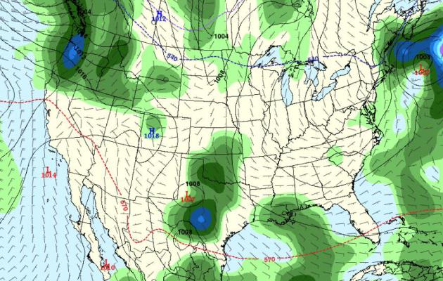

Hello Paul,
"From what I read, Hurricane Grace hit the NE US in Halloween 1991 and created the Perfect Storm. Of course, Minneapolis also got hit with the Halloween Blizzard of 1991 about the same time.
With Sandy bearing down on the NE Coast and with some predicting another Perfect Storm in that area, what is different in the Upper Midwest's atmospheric conditions that there isn't even a hint of snow here for this year, let alone a Blizzard? For those not meteorologically gifted, there would seem to be some parallel to 1991 conditiions and what's predicted for this year's Halloween's weather.
Please explain the difference in weather conditions between this year and 1991. Was there a connection between Grace and the Halloween Blizzard, and if so, why isn't that forecasted for this year? It's not like I miss 29" of snow, but would appreciate an explanation."
Thank you!
TJ Hanson

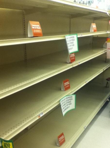
* photo of empty store shelves in Harrisburg, PA above courtesy of MD Guzy.
Climate Stories...

Photo credit above: "This is the first time an estimate of the nitrogen trapped in the Arctic permafrost has been released. Scientists had till now been using computer model based climate predictions."

The answer is number one, we’re not moving as fast as we need toAbsolutely true …
And there is a huge contrast in this campaign between myself and Governor RomneyAbsolutely true …
I am surprised it didn’t come up in one of the debates.Terrifyingly true … although President Obama and Vice President Biden literally had hours of opportunities to raise the issue since, after all, it is related to domestic and foreign policy, to budget issues and security, and to energy issues where we had President Obama and Mitt Romney arguing over who was the better friend to fossil fuels. (Hint … Romney did win this but the President made him work for the title.)"
