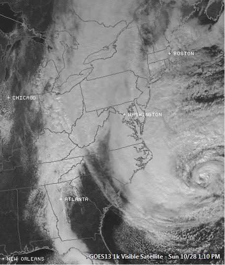
Monday, October 29th, 2012
Well, here we go... Folks in the Northeast
are gearing up for what could be an historic storm. Massive wind, power
outages, rain, storm surge, beach erosion, flooding and snow are all
going to be big issues with this system over the next few days. Weather
conditions will continued to deteriorate rapidly on Monday as Sandy
nears the East Coast, likely to make landfall at some point late in the
day.
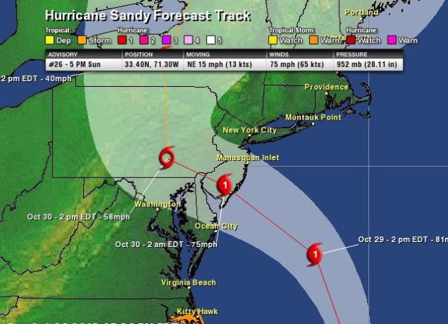
Sandy Wobbles Toward the Jersey Shore
The official National Hurricane Center
forecast for Sandy suggests that the landfall of this massive system
will be sometime Monday evening/early Tuesday morning. Don't be fooled
by the track of the storm, thinking that if you aren't in the direct
path, it won't be as bad... the effects will be extensive and far
reaching! Here is the discussion from NOAA's HPC:
HAZARDS AFFECTING LAND
----------------------
WIND...TROPICAL STORM CONDITIONS ARE ALREADY OCCURRING OVER COASTAL
NORTH CAROLINA AND SOUTHEASTERN VIRGINIA. GALE FORCE WINDS ARE
EXPECTED TO ARRIVE ALONG PORTIONS OF THE MID-ATLANTIC COAST LATER
TODAY...AND REACH LONG ISLAND AND SOUTHERN NEW ENGLAND BY MONDAY
MORNING. WINDS OF HURRICANE FORCE COULD REACH THE MID-ATLANTIC
STATES...INCLUDING LONG ISLAND...BY LATE MONDAY.
STORM SURGE...THE COMBINATION OF AN EXTREMELY DANGEROUS STORM SURGE----------------------
WIND...TROPICAL STORM CONDITIONS ARE ALREADY OCCURRING OVER COASTAL
NORTH CAROLINA AND SOUTHEASTERN VIRGINIA. GALE FORCE WINDS ARE
EXPECTED TO ARRIVE ALONG PORTIONS OF THE MID-ATLANTIC COAST LATER
TODAY...AND REACH LONG ISLAND AND SOUTHERN NEW ENGLAND BY MONDAY
MORNING. WINDS OF HURRICANE FORCE COULD REACH THE MID-ATLANTIC
STATES...INCLUDING LONG ISLAND...BY LATE MONDAY.
AND THE TIDE WILL CAUSE NORMALLY DRY AREAS NEAR THE COAST TO BE
FLOODED BY RISING WATERS. THE WATER COULD REACH THE FOLLOWING
DEPTHS ABOVE GROUND IF THE PEAK SURGE OCCURS AT THE TIME OF HIGH
TIDE...
NC NORTH OF SURF CITY INCLUDING PAMLICO/ALBEMARLE SOUNDS...4 TO 6 FT
SE VA AND DELMARVA INCLUDING LOWER CHESAPEAKE BAY...2 TO 4 FT
UPPER AND MIDDLE CHESAPEAKE BAY...1 TO 3 FT
LONG ISLAND SOUND...RARITAN BAY...AND NEW YORK HARBOR...6 TO 11 FT
ELSEWHERE FROM OCEAN CITY MD TO THE CT/RI BORDER...4 TO 8 FT
CT/RI BORDER TO THE SOUTH SHORE OF CAPE COD INCLUDING BUZZARDS
BAY AND NARRAGANSETT BAY...3 TO 6 FT
CAPE COD TO THE MA/NH BORDER INCLUDING CAPE COD BAY...2 TO 4 FT
MA/NH BORDER TO THE U. S./CANADA BORDER...1 TO 3 FT
SURGE-RELATED FLOODING DEPENDS ON THE RELATIVE TIMING OF THE SURGE
AND THE TIDAL CYCLE...AND CAN VARY GREATLY OVER SHORT DISTANCES.
GIVEN THE LARGE WIND FIELD ASSOCIATED WITH SANDY...ELEVATED WATER
LEVELS COULD SPAN MULTIPLE TIDE CYCLES RESULTING IN REPEATED AND
EXTENDED PERIODS OF COASTAL AND BAYSIDE FLOODING. IN ADDITION...
ELEVATED WATERS COULD OCCUR FAR REMOVED FROM THE CENTER OF SANDY.
FURTHERMORE...THESE CONDITIONS WILL OCCUR REGARDLESS OF WHETHER
SANDY IS A TROPICAL OR POST-TROPICAL CYCLONE. FOR INFORMATION
SPECIFIC TO YOUR AREA...PLEASE SEE PRODUCTS ISSUED BY YOUR LOCAL
NATIONAL WEATHER SERVICE OFFICE.
RAINFALL...RAINFALL TOTALS OF 3 TO 6 INCHES ARE EXPECTED OVER FAR
NORTHEASTERN NORTH CAROLINA WITH ISOLATED MAXIMUM TOTALS OF 8
INCHES POSSIBLE. RAINFALL AMOUNTS OF 4 TO 8 INCHES ARE EXPECTED
OVER PORTIONS OF THE MID ATLANTIC STATES...INCLUDING THE DELMARVA
PENINSULA...WITH ISOLATED MAXIMUM AMOUNTS OF 12 INCHES POSSIBLE.
RAINFALL AMOUNTS OF 1 TO 3 INCHES WITH ISOLATED MAXIMUM AMOUNTS
OF 5 INCHES ARE POSSIBLE FROM THE SOUTHERN TIER OF NEW YORK STATE
NORTHEASTWARD THROUGH NEW ENGLAND.
SNOWFALL...SNOW ACCUMULATIONS OF 2 TO 3 FEET ARE EXPECTED IN THE
MOUNTAINS OF WEST VIRGINIA...WITH LOCALLY HIGHER TOTALS TONIGHT
THROUGH TUESDAY NIGHT. SNOWFALL OF 1 TO 2 FEET IS EXPECTED IN
THE MOUNTAINS OF SOUTHWESTERN VIRGINIA TO THE KENTUCKY BORDER...
WITH 12 TO 18 INCHES OF SNOW POSSIBLE IN THE MOUNTAINS NEAR THE
NORTH CAROLINA/TENNESSEE BORDER.
SURF...DANGEROUS SURF CONDITIONS WILL CONTINUE FROM FLORIDA THROUGH
THE MID-ATLANTIC STATES FOR THE NEXT COUPLE OF DAYS AND SPREAD INTO
THE NORTHEASTERN STATES LATER TODAY.
President Obama: "This is a Serious and Big Storm"

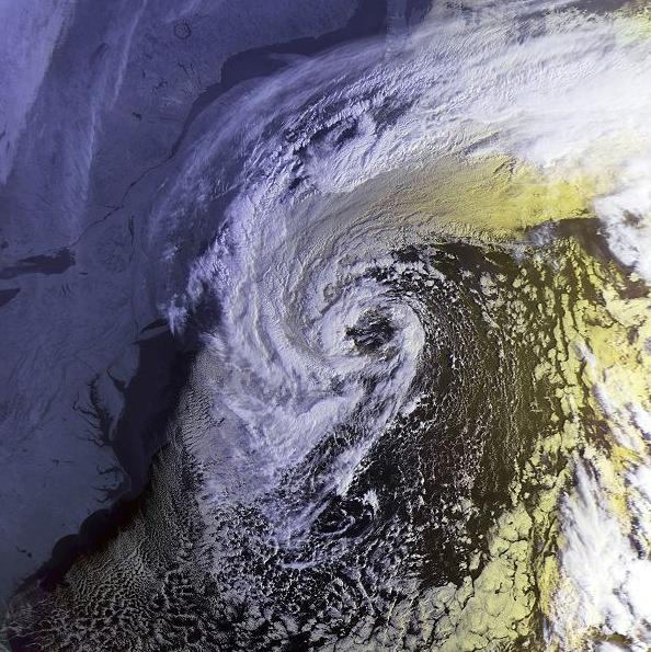
An Historic Sandy vs. "The Perfect Storm" of 1991
In some ways, Sandy will be much like "The
Perfect Storm" of 1991, when the remnants of Hurricane Grace interacted
with a cold front that moved through the Northeast. As tropical system
(strengthened by the warm ocean waters) merged with the cold front, it
became more of an typical Mid-Latitude Cyclone (strenghtened by the
large temperature difference across the front). Interestingly, the
center of the storm (minimum central pressure of 972mb) stayed off shore
and caused massive damage (estimated to over 200 million dollars with
13 dead). This storm (hybrid Sandy) is expected to MAKE landfall; some
models forecasting the central pressure down near 950mb, much lower than
that of 1991. The image below is from "The Perfect Storm" in 1991 when
it made its closest pass to the U.S.
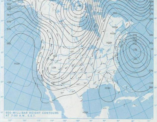
Weather Setup in 1991
The weather setup in 1991 was very similar
to that now, but the upper level maps from back then (impressive in
their own right) reveal something that wasn't as impressive as what
we're seeing now! The image below is the 500mb chart from October 30th,
1991. It shows the low off the Northeast coastline (remnants of
Hurricane Grace), which had already been interacting with a cold air
mass that had moved into the Noreast, but the upper level trough of low
pressure (upside down "U" in the western half of the country) was still
out west. In between these two areas of low pressure, a weak bubble of
high pressure allowed the remnants of Grace to stay just offshore.
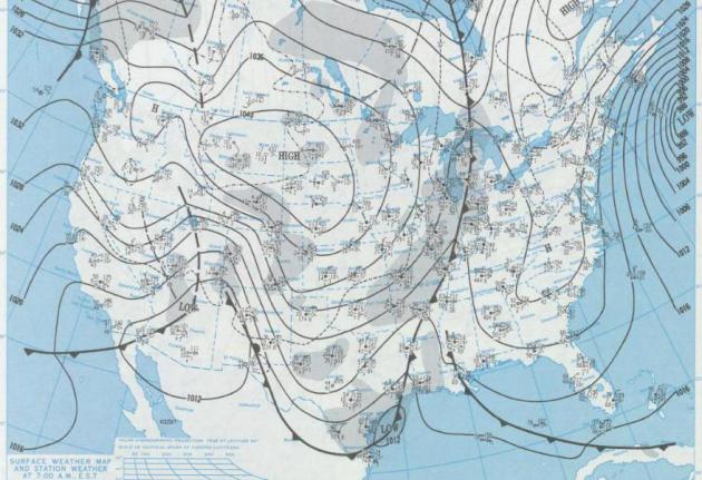
Surface Map on October 30th, 1991
The remnants of Hurricane Grace
allowed the upper level trough of low pressure to slow down, creating a
massive low to develop in the middle part of the nation. This area of
low pressure also slowed down and created the "Halloween Blizzard of
1991" to develop, which dumped nearly 30" of snow in some spots
throughout northern Minnesota!
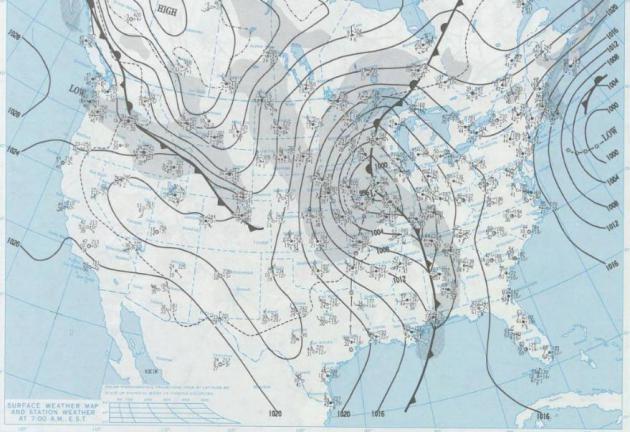
Surface Map on November 1st, 1991
This was the day after
Halloween, when the "Halloween Blizzard" was really blasting
Minnesota... Record snowtotals from that event (in several locations)
have never been touched since!
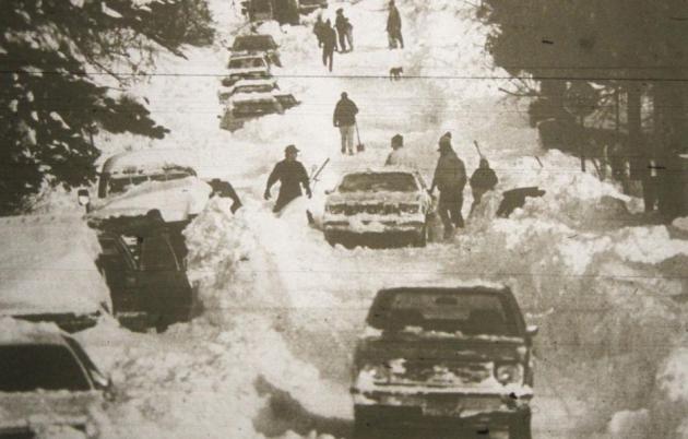
Record Snow Totals Around the Twin Cities in 1991
"Across much of eastern
Minnesota, trick-or-treaters donned snowmobile suits as snow began to
fall during the afternoon of October 31, 1991. This marked the beginning
of a major winter storm that pounded the eastern half of Minnesota over
a three day period. The storm dropped 28.4 inches of snow on the Twin
Cities, setting a single storm record for the metropolitan area. Duluth
received 36.9 inches, the largest single storm total in Minnesota
history."
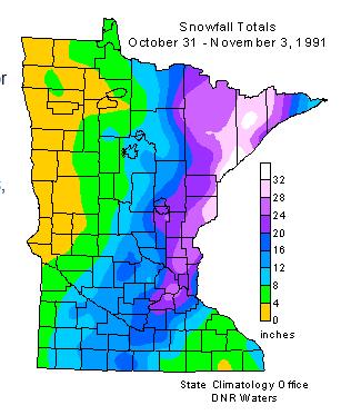
(Photo Courtesy: Bob King News-Tribune)
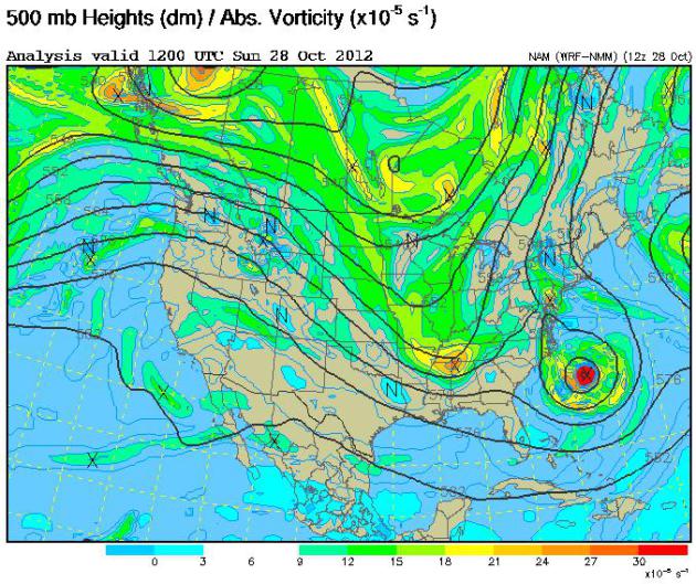
Weather Setup Nearly 21 Years Ago to the Day!
Let's take a look at the upper level map
(500mb) from Sunday, October 29th, 2012. Note the difference this time
around as that upper level trough of low pressure is in the eastern half
of the United States. Not only is this bringing a fresh batch of cold
air with it to help deepen the storm, but the trough of low pressure is
also helping to suck the storm back inland towards the Northeast. As the
trough of low pressure swallows the remnants of Sandy into the
Northeast, the merging of these two systems as well as the strong
temperature difference is going to help make this storm even more
perfect than "The Perfect Storm" of 1991!
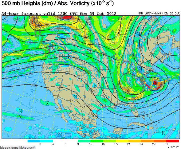
The 500mb vorticity map by AM Monday shows the upper level trough and the remants of Sandy starting to merge.
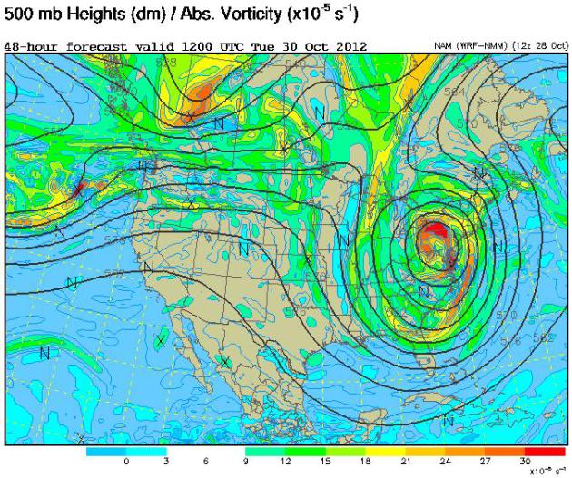
AM Tuesday - Full Merge
This is the 500mb voticity map by AM Tuesday, which shows that the upper level trough of low pressure and the remnants of Sandy have merged completely. This will result in one of the largest upper level low pressure systems I've ever seen over the Northeast. Look at the lines of equal air pressure (isobars) and note how widespread it is. The result here will be an EXTENSIVE wind field surrounding the very impressive hybrid low pressure system.
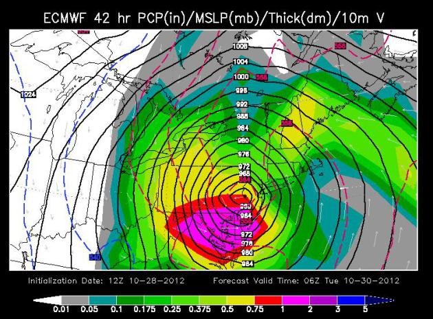
ECMWF (European) Model
This has been the most consistent model thus far... beating every other model to the punch last weekend with the scope and magnitute of the potential storm and yet again, it is consistent! Nearly spot on with its last several runs over the course of the week, it brings a near 950mb central pressure storm into the Northeast by Monday evening.
947mb Low Forecast by the GFS
At the surface, the area of low pressure will be even stronger! The GFS is forecasting a 947mb central pressure just prior to making landfall Monday evening. The lines of equal air pressure (isobars) are even more tightly packed, which will result in significant winds, likely for days, but tapering a bit by the middle and end of the week.
Here was an Interesting quote from the Baltimore, MD/Washington D.C. NWS discussion:
"I cannot recall ever seeing model forecasts of such an expansive areal wind field with values so high for so long a time. We are breaking new ground here."
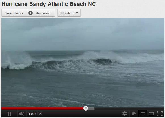
Significant Waves, Surf and Beach Erosion
One of the biggest concerns about this system is going to be the serious lashing across the coastal communities. Waves heights will be extreme, the storm surge will also be aided by the near full moon and high tide, which ultimately will have a dramatic impact of beach erosion along the beaches of the Eastern Seaboard.
Watch the waves from North Carolina thanks to Storm Chaser:
Impacts from Sandy (listed in rough order of priority, in terms of damage potential and number of people/companies impacted):
1). Storm surge: we expect the worst storm
surge flooding out ahead of Sandy to take place late morning, again
late evening on Monday, coinciding with high tide (and a full moon
Monday PM hours). Tides are already 2-3 feet higher than average due to
astronomical conditions – Sandy’s sustained winds and low pressure
(28.25”) will create a dome of water that will be pushed ashore in two
major surges: 9 am – noon, again 9 pm – midnight Monday.
2). Winds: sustained winds of 50-75 mph are
likely in a 300 mile swath Monday and Monday night, the strongest
winds over southern New England and Long Island Monday PM hours, with
gusts over 90 mph at times. There will be wind damage, downed trees and
power lines – I expect a rash of power outages. Companies with
well-maintained generators will be glad they made that investment by
midday Monday.
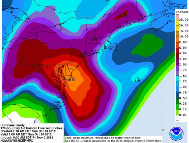
3). Inland flooding. One bit of (better)
news: the rainfall amounts from Sandy don’t look quite as extreme as
they did 2-3 days ago. Some 4-8” amounts are still likely from the
Delmarva Peninsula to coastal New Jersey, but New York, Long Island and
most of southern New England will probably receive less than 3-5” of
rain – still capable of flash flooding, but not the (historic) rainfall
amounts we feared last week. One complicating factor: leaves. The
timing is problematic, with leaves on the ground, leaves that will be
swept into storm sewers, exacerbating the flood risk and accelerate the
backing up of water in many residential and commercial areas.
Maximum Storm Surge for New Jersey. According
to NOAA “Slosh” models a 5-6 foot surge is most likely to occur during
the early morning hours Monday, close to 7-9 am, coinciding with high
tide.
Dangerous Storm Surge #1. NOAA surge models
suggest a 9 foot storm surge (above normal sea level) during the late
morning hours Monday over far western Long Island Sound, capable of
pushing very significant water in Queens and Brooklyn.
Dangerous Storm Surge #2. A second, even
higher surge is forecast for the late evening hours Monday, as the
center of Sandy comes ashore over central New Jersey – sustained 60-80
mph winds whipping up a dome of water as much as 10 feet above normal
sea level over eastern Long Island, with an 8-9 foot surge for
Greenwich, Stamford and Westport.
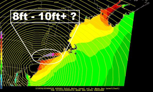
SLOSH Models... Storm Surge
The National Weather Service has a nice product
that suggests the storm surge expected near New York, Long Island and
the Jersey Coastline. If this were to verify, these areas could easily
see an 8ft. to 10ft.+ storm surge as this storm approaches!
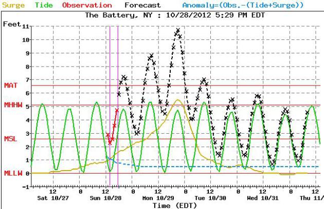
Point Forecast SLOSH Model
Look at the point data forecast for The Battery, NY... it is suggesting a near 11ft. storm surge by Monday evening.
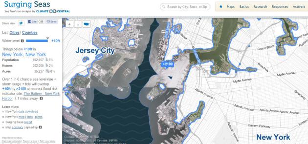
Surging Seas...
The image below suggests all the places the potentially could be impacted by flood water if the storm surge would climb to 10ft.
NYC Gearing Up for Superstorm
Thanks to my good friend Peter Brooks for this picture out of NYC. Peter said that businesses were already closing on Sunday ahead of the powerful storm. Look at this massive line outside a Trader Joe's, hoping to get supplies before the big storm hits.

Superstorm Causes Thousands of Flight Cancelations...
I sure hope you didn't have any big travel plans out east this week. According to The Washington Post, there have been thousands of flights cancelled with more possibly to come:
Read More HERE:
"NEW YORK — Airlines canceled more than 5,000 flights mostly as a result of Hurricane Sandy, with hubs along the East Coast bearing the brunt of the disruptions.
According to the flight-tracking service FlightAware, 1,100 Sunday flights have been canceled as of Sunday afternoon, with more than 265 cancellations at Newark Airport, a hub of United Airlines
For Monday, nearly 4,000 flights were canceled, with 857 cancellations at Newark, followed by 632 at New York’s Kennedy Airport and more than 500 cancellations at both New York’s LaGuardia and Philadelphia International.
FlightAware said it expects the number of flight cancellations for Monday and Tuesday to “rise considerably.”"
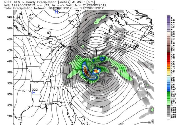
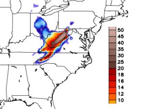
Significant Rainfall/Flooding
This storm has the potential to dump copious amounts moisture in the Northeast, likely to cause inland flooding in spots. Some of this moisture will even fall in the form of very heavy snowfall, likely to cause widespread power outages across parts of the Appalachians.
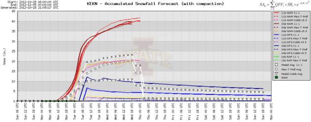
Significant Snowfall
The models have been consistently printing out a staggering amount of snow across the higher elevations of the Appalachians through the middle part of the week! In some cases, there could be 3ft.+. This will be a very wet, heavy snow, so there will likely be downed trees and power lines, which will cause power outages.
Meteogram Output From Elkins, WV
I can honestly say that I've never seen this before from this meteogram. Look at the projected snowfall accumulation from Elkins, West Virginia. Some of the models are suggesting over 40" of snow!
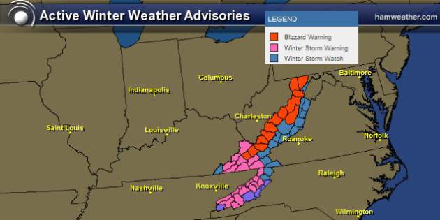
Winter Weather Headlines Posted
These are all of the winter weather headlines that have been posted for parts of the Appalachians and surrounding areas.
...BLIZZARD WARNING IN EFFECT FROM NOON MONDAY TO 4 PM EDT
WEDNESDAY...
THE NATIONAL WEATHER SERVICE IN CHARLESTON HAS ISSUED A BLIZZARD
WARNING...WHICH IS IN EFFECT FROM NOON MONDAY TO 4 PM EDT
WEDNESDAY.
* LOCATIONS...BEST CHANCES ACROSS HIGH TERRAIN...BUT CAN NOT BE
RULED OUT IN THE VALLEYS.
* HAZARD TYPES...HEAVY WET SNOW...AND STRONG GUSTY WINDS.
* SNOW ACCUMULATIONS...RANGING FROM 1 TO 6 INCHES BELOW 2000
FEET...TO 1 TO 2 FEET ABOVE 3000 FEET.
* WINDS...INCREASING ON MONDAY WITH GUSTS OF 35 TO 45 MPH. SOME
OF THE HIGHEST RIDGES COULD GUST TO NEAR 50 MPH.
* VISIBILITIES...WHITEOUT CONDITIONS AT TIMES.
* TIMING...RAIN WILL CHANGE TO SNOW OVERNIGHT SUNDAY NIGHT ACROSS
HIGH TERRAIN...WITH SOME ACCUMULATIONS OCCURRING SUNDAY NIGHT
AND EARLY MONDAY. HEAVIEST ACCUMULATIONS AND STRONGEST WINDS ARE
EXPECTED MONDAY AFTERNOON INTO TUESDAY. LOWER ELEVATIONS MAY
STRUGGLE TO CHANGE OVER TO SNOW. BEST CHANCES FOR CHANGING TO
SNOW IN THE LOWER ELEVATIONS WOULD BE MONDAY NIGHT INTO TUESDAY.
* IMPACTS...THE HEAVY WET SNOW MAY BRING DOWN TREE LIMBS...
CAUSING POWER OUTAGES OR FLUCTUATIONS. SNOW LOADING...OR THE
WEIGHT OF THE SNOW...MAY CAUSE STRUCTURAL DAMAGE...INCLUDING
COLLAPSING ROOFS. THE COMBINATION OF SNOW AND WIND WOULD LEAD TO
REDUCED VISIBILITY.
Thanks for checking in, don't forget to follow me on Twitter @TNelsonWNTV