Significant Rains For Some. Here's an excerpt of Mark Seeley's (always-excellent)
WeatherTalk blog: "
Then
over Wednesday night and Thursday additional persistent rains fell in
southeastern Minnesota where Lanesboro and Harmony reported 2.15
inches, Spring Valley 1.77 inches, Winona 1.70 inches, Zumbro Falls
1.67 inches and Chatfield 1.30 inches. Elsewhere in eastern counties
snow and snow flurries were widely reported on Thursday, though most
were not significant amounts. Among those getting measurable snowfalls
were Babbitt and Cook with 3 inches and Ely with 4.8 inches. Total
rainfall for the week was equivalent to an entire month of October for
some, but these observers were few and far between. There was
relatively little change in drought status across the state. You can
find more on this at.....http://climate.umn.edu/doc/journal/drought_2012.htm". Photo: Brad Birkholz.
Hybrid Superstorm
Will this storm be as bad as the media is
portraying? Is it more meteorological hype? I don't think so, because of
a convergence of factors. Sandy is a massive storm, forecast to be 500
miles wide, with a cone of hurricane-force gusts nearly 200 miles in
diameter. The storm is predicted to move slowly, blocked from shooting
north by a stalled high pressure bubble.
Throw in a full moon (Monday afternoon) and 50
million Americans in the high-impact zone, and you have a recipe for
trouble. Landfall is most likely in Delaware, but models are nudging the
track north over time. New York and Long Island are not out of the
woods; the worst storm surge (10-20+ feet) just north of where Sandy
hooks inland Monday or early Tuesday.
The lesson of Hurricane Irene last year: don't
underestimate the threat posed by inland flooding, which will impact the
most people.
Unlike 1991's "Perfect Storm" over New England
we don't have a storm nearby. No, we won't get 30 inches of snow this
time around.
We enjoy cool sun into most of next week with a
warming trend; highs near 50 for Halloween. The next chance of rain: a
week from today. No weather worries.
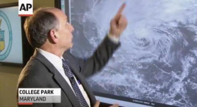
National Weather Service: "A Storm Like No Other". Details (and video) from
The Associated Press: "
The
National Weather Service says Hurricane Sandy is an extremely unique
storm that will hit the U.S. with strong winds and rain, potentially
causing massive damage."
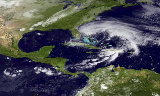
Frankenstorm 2012: Sandy "Hybrid" To Hit Northeast.
We're seeing a higher amplitude weather pattern in recent years, weather
systems deeper, moving slower. Could record Arctic ice melt this summer
be having an impact, helping to generate fewer (but stronger) storms
like Sandy's spawn? Details from
Huffington Post; here's an excerpt: "
Hurricane Sandy
has already slammed Cuba, bringing heavy rain and winds around 110
miles per hour on Thursday, as it moved north. By Friday morning, the
death toll had already risen across the Caribbean. Climate Central
reported that the jet stream winds boxing in Sandy and creating a "Frankenstorm" are part of "blocking patterns [which] have appeared with greater frequency and intensity in recent years."
Some scientists have suggested the patterns could be linked to 2012's
record Arctic sea ice loss, which exposes more open water to absorb the
sun's energy. Representative Ed Markey (D-MA) released a report
Thursday, saying, "If climate change continues unchecked, Hurricane Sandy won’t be our October surprise, it could be the new normal for New England...."
Hurricane Sandy: Freaky Forecast Prompts State of Emergency Declarations. Here's an excerpt from a good story at
The Washington Post: "...
Maryland’s Emergency Management Agency went further with its list hurricane/winter storm recommendations:
— Pay attention to weather forecasts
— Prepare for power outages of several days
— Gather blankets; temperatures will be 20 degrees cooler after the storm.
— Don’t turn on generators in basements or garages, take them outside where ventilated
— Charge cell phones, and buy a car charger for your phone if you don’t have one.
— Secure loose items, like patio furniture and grills."
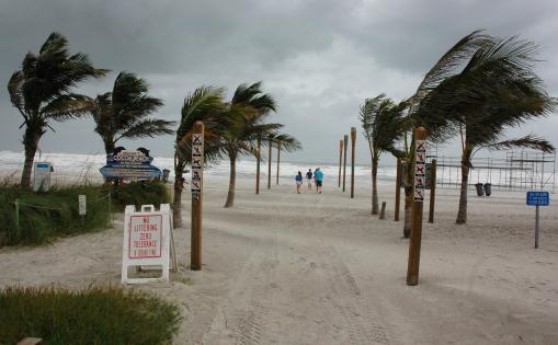
Image credit above: "
Beachgoers venture out to the end of
Minutemen Causeway in Cocoa Beach, Fla., around lunchtime to see the
waves, getting sandblasted from the wind and sand, due to the effects
of the outer bands of Hurricane Sandy." Friday, Oct. 26, 2012. (AP Photo/Florida Today, Malcolm Denemark)
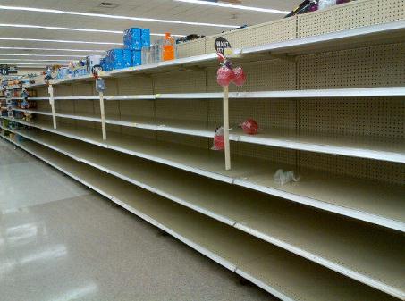
Empty Storeshelves. Amber Dawn snapped this photo Friday in Washington D.C. - via
Twitter. Yep, looks like a storm's coming...
Philly Mayor Tells People In Flood-Prone Regions To Leave.
State of Emergency in Pennsylvania, and now Philadelphia's mayor is
telling locals with a history of flooding to err on the side of caution
and get out now. Details from
NBC 10 Philadelphia.
State of Emergency: Virginia, Maryland, Delaware, Pennsylvania, and New York State (as of Friday night).
Sandy Nuggets From Meteorologist Alex Buck. Alex is
one of our (amazing) producers at WeatherNation TV. Here are some of the
highlights he gleaned from a NOAA-FEMA conference call Friday:
* Incident management teams and emergency resources are being moved
into the Northeast and Mid-Atlantic states. Local officials determine
evacuations, not FEMA. Craig Fugate, the FEMA Administrator briefed the
President this morning on the possible impacts across the NE and MA.
Sandy will change from a tropical system to an extra tropical system
sometime soon. It is still too difficult to pinpoint exactly where the
system will hit, but confidence is at 90% that it will hit the NE.
* This was the interesting thing: The storm could cover the eastern
third of the country. Winds greater than 50 kts (58 MPH) are expected
from the Carolinas to Maine. There is a full moon on Monday and
astronomical tides peak shortly after that, exactly when Sandy would
hit. Snow is expected in West Virginia and as far east as Ohio on
Tuesday.
* The Navy is moving ships out of Hampton Roads, Norfolk, VA in preparation for Sandy.

Here is the
Alerts Broadcaster
Update I just sent out to our corporate clients. In the name of public
safety and erring on the side of caution I wanted to share this with the
general public:
The stage is set for an historic storm over the
Mid-Atlantic and southern New England early next week, an unfortunate
convergence of meteorological (and astronomical) events, leading to the
formation of a huge storm capable of widespread damage, from winds,
waves and inland flooding. I am not an economist, but based on where the
highest impacts are predicted, I see no reason why this won’t be a
billion dollar storm, capable of extended power outages, beach erosion
and coastal flooding that may take weeks to repair and restore.
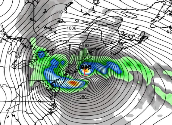
What makes Hurricane Sandy different?
1). Size of the storm. Sandy will be nearly
500 miles wide within 48 hours, with a 300 mile radius of tropical storm
force winds, and a 100-200 mile radius of hurricane-force wind gusts
Sunday night into Tuesday.
2). Duration of the storm. Unlike Irene,
which moved quickly ashore late August, 2011, Sandy, a hybrid
hurricane/Nor’easter, will move slowly, “hooking” westward, prolonging
the amount of time sustained, high winds can carve out a significant
storm surge, and extending the period of time when flooding rains will
fall well inland.
3). Astronomical Bad Luck. A full moon is
coming Monday afternoon, about the time Sandy will be pushing toward
coastal Delaware or New Jersey, increasing tides, making the resulting
storm surge even more severe.
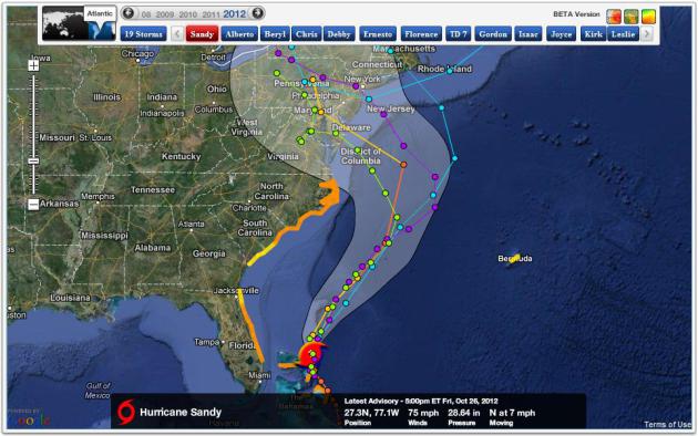
Hurricane Sandy has weakened slightly in the last 24 hours,
now a minimal Category 1 storm with 75 mph sustained winds. But don’t be
fooled – a jolt of energy from an approaching surge of much colder,
Canadian air will reenergize Sandy, causing it to strengthen
significantly into the weekend. The analog is Hurricane Grace in late
October, 1991 – some of the energy and moisture from Grace went on to
fuel “The Perfect Storm”, which battered New England with
hurricane-force winds on Halloween, 1991. There is growing speculation
that “Sandy” could be considerably worse than “Grace” in 1991, and Irene
in late August of 2011, due to the size and duration of the storm, as
well as a full moon (Monday) - and the population centers impacted.
Image: Naval Research Lab.
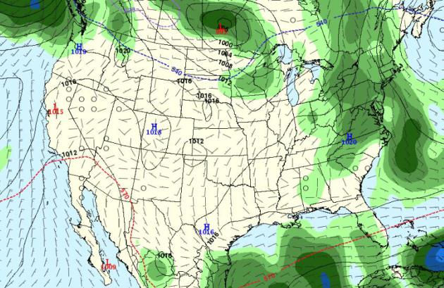
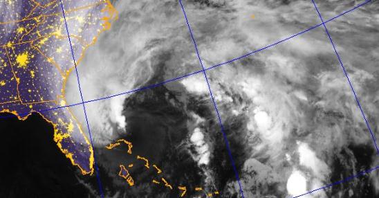
Tropical Storm Watch. NOAA NHC has extended a Tropical Storm
watch from Savannah northward to the Outer Banks of North Carolina. I
expect this to be upgraded to a Hurricane Watch for the Outer Banks by
tomorrow morning, and Hurricane Watches/Warnings may have to be issued
as far north as Long Island, Providence and Cape Cod by Sunday night and
Monday, depending on the final track and intensity. It’s important to
follow instructions from local authorities, and now wait until the last
moment to evacuate. I’m especially concerned about barrier islands, from
North Carolina to Long Island, and the amount of time necessary to
safely evacuate residents from the most vulnerable regions, within 5-8
feet of sea level. My advice: get out ahead of the curve and move people
faster, especially those near sea level.
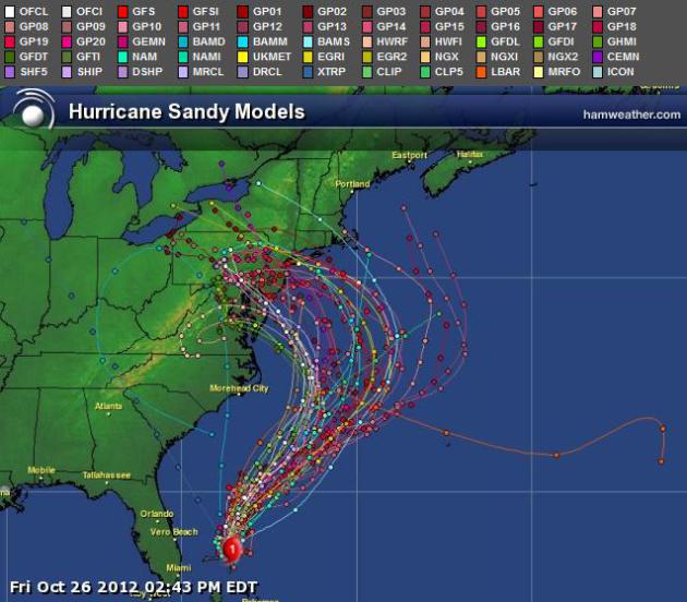
Image:
Ham Weather.
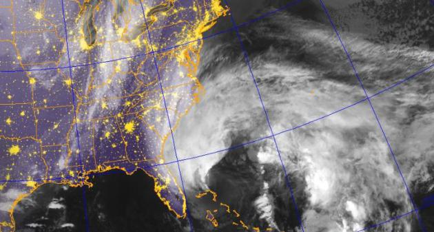
Model Ensemble. There has been a slight northward shift in the
models in the last 12 hours. Although the most likely track of Sandy
brings the core/eye of the storm into coastal Maryland or Delaware late
Monday or very early Tuesday, a slight northward wobble in the track
would bring the strongest winds/surf into New Jersey and metropolitan
New York/Long Island. It’s this scenario that I’m most concerned about.
Map:
Ham Weather.
* The odds of serious flooding/storm surge impacts
in New York Harbor and the southern coastline of Long Island have
increased from 30 to 40% in the last 12 hours. Your contingency plans need to include metro New York and Long Island.
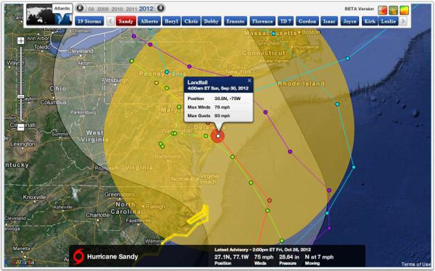
Most Likely Landfall. Based on model trends the most likely
landfall is near Bethany Beach or Rehoboth, Delaware during the very
early morning hours on Tuesday, September 30. But keep in mind that the
strongest winds – highest storm surge – will come within 24 hours of
landfall, so conditions will deteriorate Sunday, with the worst
wind/wave/flooding Monday into Tuesday.
Model guidance: NHC and
Ham Weather.
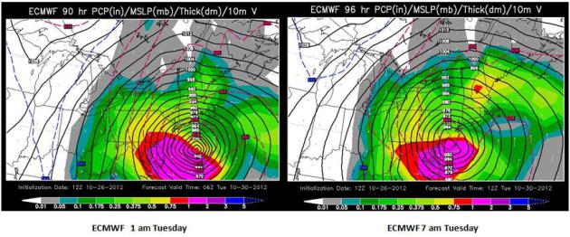
European Solution. The ECMWF has done the best job with Sandy,
to date, so I’m putting more weight on this solution. The latest
guidance shows Sandy tracking almost due west Monday into early Tuesday,
pushing a surge of water into southern New England, Long Island and New
York Harbor, before the eye/center of this hybrid storm comes ashore
over southern New Jersey or Delaware Tuesday morning. This constitutes a
slight northward shift to the track from previous model runs. It’s
worth pointing out that NHC, the National Hurricane Center, is putting
much more weight on the ECMWF and the GFS models for their (official)
forecasts, in essence splitting the difference between the two.
Images above: WSI Corporation.
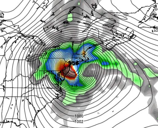
NOGAPS Model. The Navy’s NOGAPS model has a more northward
solution, one that prove much worse for southern New England, from Cape
Cod to Martha’s Vineyard, Long Island and metro New York City. As such
it falls fairly closely into line with the GFS model (below).
Map above: Weather Bell.
Why Boston Residents Can’t Let Their Guard Down Just Yet.
There’s still a (disturbingly) large spread in model solutions. By this
time, within 72-82 hours of landfall, you would expect more agreement
between the models, but that’s not to be, at least not yet. The GFS is
something of an outlier, with a (much) farther northward track, one that
would prove damaging for Boston and Cape Cod. With a sustained
(offshore) wind flow over New York this solution would actually spare
New York Harbor and Long Island from the worst storm surge, but Boston
might wind up enduring a 1 in 100 year storm/flood. Right now our
official track forecast splits the difference between the ECMWF and the
GFS, with probable landfall from Delaware into southern New Jersey.
Near-Blizzard Conditions. Well inland, enough cold air may be
in place for a foot of snow or more over the hills of West Virginia,
enough snow to plow and shovel over parts of western Pennsylvania.
Map: Weathercaster.com.
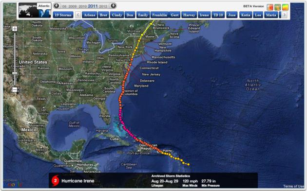
Why Sandy Is No Irene. Irene was a big fizzle, at least for
New York City, where the storm surge wasn’t nearly as severe as many had
feared. Irene moved quickly, 30 mph to the north/northeast. There was
less time for extended winds to create a powerful storm surge for New
York Harbor and Long Island. Not to minimize the headaches and
heartaches triggered by Irene - but the storm surge wasn't nearly as bad
as predicted. By comparison Sandy, or what Sandy mutates into, will
move slower, not racing northward, but curving westward, leaving more
time to generate a significant storm surge. The surge is created by the
combination of sustained winds, low pressure and underwater geological
considerations, the slope of the continental shelf. The result: a bulge
of water some 5-15 feet above normal high tide that pushes ashore near
the eye/center of the storm. Image:
Ham Weather.
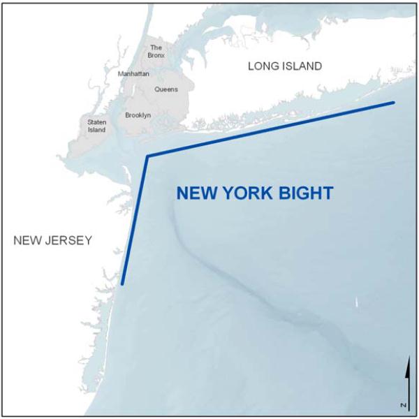
The New York Bight. New York City is at a geographical
disadvantage; the combination of sustained east/southeast winds can
funnel water toward the Hudson Valley Shelf. This “piling effect” can
compound a storm surge, especially when a major storm tracks 25-100
miles south of Manhattan. Expect to hear more about the New York Bight
and how this might magnify a predicted storm surge Monday into early
Tuesday.
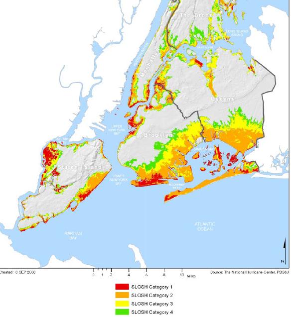
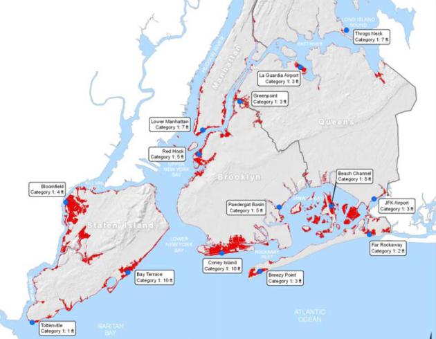
“SLOSH” Analysis. The Office of Emergency Management utilizes a
“SLOSH” Analysis to predict which regions of New York City are most
vulnerable to a storm surge. Here’s a description from the
New York City Natural Hazard Mitigation Plan (2009):
Vulnerable Areas In A Category 1 Hurricane. Lower Manhattan,
portions of Brooklyn, Queens and Staten Island would be inundated during
a Category 1 storm, especially one that passes just south of New York,
with southeast winds at the surface, funneling water into the New York
Bight. Maps courtesy of the New York City Natural Hazard Mitigation Plan
(2009).
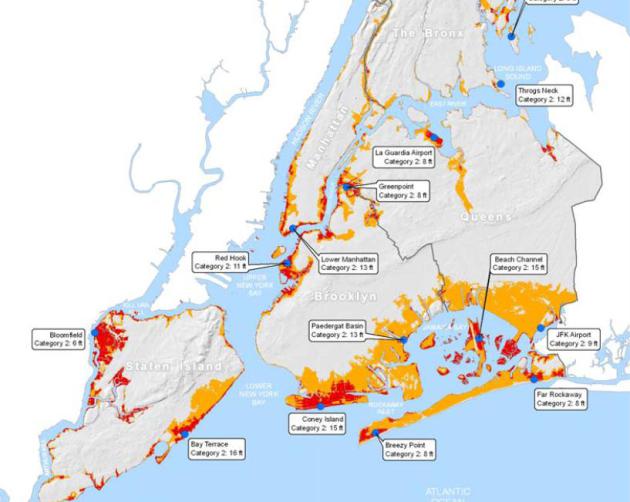
Vulnerable Areas In A Category 2 Hurricane. The area at risk
expands from a Category 2 storm, with sustained winds over 95-100 mph.
This seems unlikely right now – if Sandy does impact metro New York and
Long Island it will probably be as a Category 1 hurricane, or equivalent
Nor’easter.
Summary: Meteorological and astronomical
conditions are aligning for a 1 in 100 year storm for much of the
Northeast and Mid-Atlantic region. Although a precise landfall estimate
from Sandy remains unclear, residents from coastal Maryland and Delaware
northward to New Jersey, New York City, Long Island, Providence, Cape
Cod and Boston need to be on high alert, with contingency/evacuation
plans ready to go. The greatest probability of landfall from Sandy is
coastal Delaware or south Jersey Monday night and early Tuesday, but the trend is for models to nudge this landfall zone north over time.
We know Sandy is going to be an historic storm
– and in spite of lingering uncertainty focused on the exact location
of landfall, it would be prudent to take all necessary precautions to
safeguard life and property, especially coastal regions, within 5-8 feet
of sea level, from Ocean City, Maryland and Rehoboth, Delaware
northward to coastal New Jersey, metro New York, Long Island and Cape
Cod. The impacts from Sandy may be felt well into November.
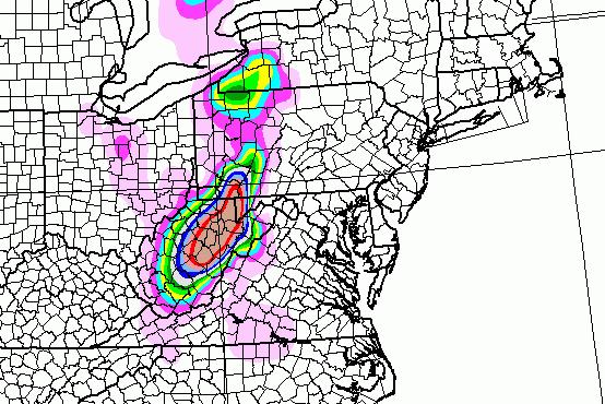
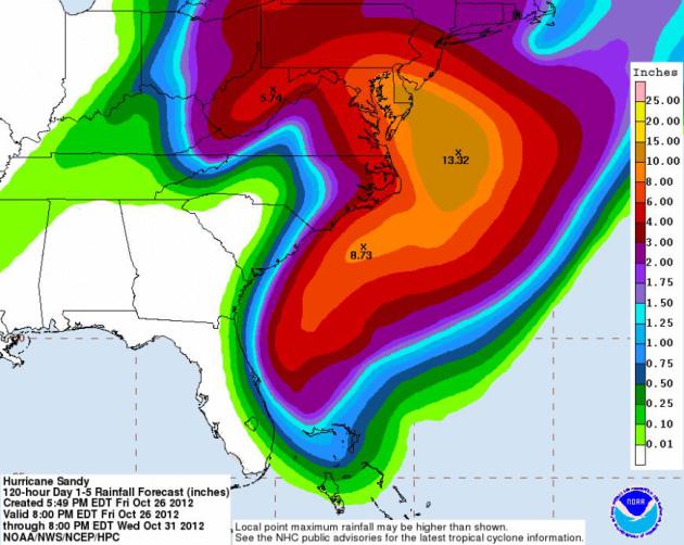
120 Hour Rainfall Forecast. The big lesson from
Hurricane Irene last year: don't underestimate inland flooding from
hurricane rains. The winds and waves get the most attention, but often
more people are impacted by severe flooding 50-300 miles inland, in some
cases days after landfall. Sandy may produce some 6-10" rains from the
Delmarva Peninsula into New Jersey. Map:
NOAA HPC.
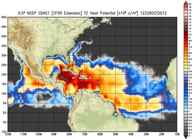 Sea Surface Temperatures
.
Water temperature in the Gulf Stream are still a few degrees warmer
than average, which may sustain Hurricane Sandy unusually far north (for
late October). The storm will become extra-tropical, deriving most of
its energy from a sharp temperature contrast and a deepening trough of
low pressure as high-velocity winds tighten up the pressure gradient - a
blocking fair weather high over Greenland preventing Sandy from
accelerating north, out to sea, turning it inland by Monday. Map: NOAA.
Experts: Team Obama Should Root For Hurricane Sandy To Interrupt Election. And what a mess that would be;
U.S. News and World Report has an intriguing story - here's an excerpt: "...
Pastor
says a natural disaster that impacts the election would "stretch the
fabric of American Democracy to the point of being torn" because, in
many cases, local disputes over voting "would be addressed in an area
where one party is largely dominant and the rules are extremely weak."
So far, American elections have been fairly natural disaster-free.
Hudak says there have been some "small scale issues" with blizzards in
the upper plains and Rocky Mountain states in previous elections. With
any luck, that streak will continue in 2012. But even if Sandy isn't
catastrophic, inclement weather throughout the country could have a more
predictable impact on the election..."
*
Election In Sandy's Shadow. Politico.com reports on the implications of Hurricane Sandy complicating the 2012 Election; details
here.
Election Day Weather. Here is the GFS (very
extended) Outlook for Tuesday evening, November 6. Showery rains are
likely from Ohio into much of the Northeast, a few showers from the Twin
Cities and western Wisconsin, dry weather over most of the south and
west.
"Ask Paul". Weather-related Q&A:
Hello Paul,
"From
what I read, Hurricane Grace hit the NE US in Halloween 1991 and
created the Perfect Storm. Of course, Minneapolis also got hit with the
Halloween Blizzard of 1991 about the same time.
With Sandy bearing down on the NE Coast and with some predicting another
Perfect Storm in that area, what is different in the Upper Midwest's
atmospheric conditions that there isn't even a hint of snow here for
this year, let alone a Blizzard? For those not meteorologically gifted, there would seem to be some parallel to 1991 conditiions and what's predicted for this year's Halloween's weather.
Please explain the difference in weather conditions between this year
and 1991. Was there a connection between Grace and the Halloween
Blizzard, and if so, why isn't that forecasted for this year? It's not
like I miss 29" of snow, but would appreciate an explanation."
Thank you!
TJ Hanson
TJ - thanks for a great question. The big difference this time
around: there are no storms nearby, capable of stalling and squeezing
out heavy, sustained rain (or snow). The 1991 "Perfect Storm" stalled
over New England, which caused a Minnesota storm to stall over Lake
Superior, prolonging our snow for 2-3 days, whipping up nearly 30" of
snow (as many of us remember vividly). This time around high pressure
will stall overhead, keeping us partly sunny, cool and quiet into much
of next week.
 Some People Have Too Much Free Time
. No, Sandy is no laughing matter. I'm sorry - very poor taste. I will be punished.
Slow Jam Weather. Yep, we have a good time on
TPT Almanac.
Last Friday I did the weather, with my son (Walt, of "The Lost Wheels")
playing lead guitar. A weather-music mash-up. I doubt it'll ever catch
on, but we did have some fun experimenting with a new (and
forgettable) weather format! Thanks to David Gillette from TPT Almanac
for taking a chance...
Climate Stories...
It May Be Too Late To Start Global Warming. I'm a
naive optimist, but I agree. We have to move from ill-fated attempts at
(global) regulation, which are probably doomed to failure... to
adaptation, and quickly.
ABC News has the story - and video clip with Diane Sawyer; here's an excerpt: "
Here's
a dark secret about the earth's changing climate that many scientists
believe, but few seem eager to discuss: It's too late to stop global
warming. Greenhouse gasses pumped into the planet's atmosphere will
continue to grow even if the industrialized nations cut their emissions
down to the bone. Furthermore, the severe measures that would have to
be taken to make those reductions stand about the same chance as that
proverbial snowball in hell. Two scientists who believe we are on the
wrong track argue in the current issue of the journal Nature Climate
Change that global warming is inevitable and it's time to switch our
focus from trying to stop it to figuring out how we are going to deal
with its consequences.."
MTV Shatters Climate Science With Serious Question To President Obama, And Obama Gives A Serious Response. Here's an excerpt from an article at
getenergysmart.com: "..
.And, from President Barack Obama, Calloway received a serious answer from the get-go:
The answer is number one, we’re not moving as fast as we need to
Absolutely true …
And there is a huge contrast in this campaign between myself and Governor Romney
Absolutely true …
I am surprised it didn’t come up in one of the debates.
Terrifyingly true … although President Obama and Vice President
Biden literally had hours of opportunities to raise the issue since,
after all, it is related to domestic and foreign policy, to budget
issues and security, and to energy issues where we had President Obama
and Mitt Romney arguing over who was the better friend to fossil fuels.
(Hint … Romney did win this but the President made him work for the
title.)"
Could Climate Change Be The Epitome Of Partisanship? Pacific Standard has a thought-provoking story; here's a snippet: "
It’s the issue that dare not speak its name – climate change. As the New York Times, NPR, the Associated Press and a host of pundits, including our Tom Jacobs,
have noticed, talk of global warming has been banished from the
hustings in this year’s U.S. presidential campaign. While both Barack
Obama and Mitt Romney embrace talk about energy – whether from fossil
fuels or renewable sources – with various amounts of gusto, the focus is
always economic, not environmental. Despite his muted voice this year,
in years past Obama has been an ardent believer in anthropogenic
climate change. Romney has said he accepts the that the planet is
warming, and that people have played some part in the increase, but it’s never been a centerpiece of his platform. The environment is not among the 27 issues on his campaign website, although energy is, and his position has seen a rightward shift, as CBS News described it..."

