Rare October Severe Outbreak.
SPC
has a broad swath of America in a "slight risk", from Green Bay and
Rochester, Minnesota southward to Austin, Texas. The red area shows an
enhanced risk, a 30% probability of severe weather within 25 miles of
any location from Oklahoma City and Tulsa to Kansas City and Des Moines.
Expect severe storms later today, a few supercells sprouting along the
I-35 corridor may produce large tornadoes.
Lifted Index. According to
twisterdata.com
lifted indices are forecast to drop as low as -7 to -9 from Oklahoma
City to Wichita this evening, enough instability (coupled with wind
shear aloft) capable of spinning up a few large, long-lasting tornadoes.
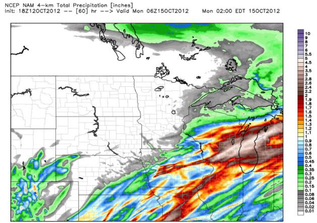
So close...and yet so far:
Total Rainfall By Sunday Night. Here is 4 km. NAM
model data valid 1 am Monday morning, showing some 2-3" amounts near
Madison and Milwaukee; the heaviest rain bands passing south and east of
Minnesota.
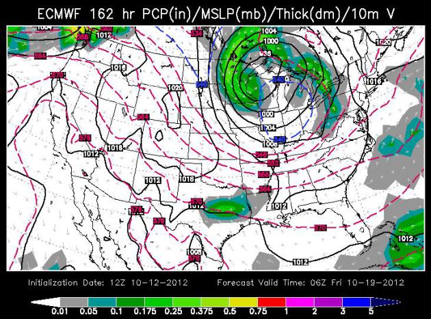
Hints of Winter. The ECMWF model output above shows a
storm "cutting off" from the main belt of westerlies over the Great
Lakes midnight, next Thursday, moisture wrapping all the way around the
low pressure system, approaching from the north. With 850 mb
temperatures close to 32 F. I wouldn't be surprised to see a little wet
snow mix in, especially over the northern half of Minnesota. Map above:
WSI Corporation.
“
We only have so many major physical features on the planet, four
or five, and you don’t really want to just start breaking them. That’s
why we can’t have nice things.” - 350.org enviromentalist Bill
McKibbon, appearing on HBO's "Real Time with Bill Maher". Check out one
of the more important video clips you'll watch this year, a 12 minute
interview from
grist.org. Image: NOAA/PMEL
Expected Rain A Drop In Bucket. Amen to that. Bill McAuliffe at
The Star Tribune summarizes the state of our drought, and (growing) impact on lake and river water levels statewide; here's an excerpt: "...
Across
Minnesota, meanwhile, rivers and lakes are gasping. The St. Louis
River near Scanlon, which rose to a record height in June and tore
apart Jay Cooke State Park, was at what appeared to be its
second-lowest height in more than 60 years Wednesday. The Minnesota
River at Jordan was down to one-seventh of its historical average for
the date. State rivers are contributing so little to the Mississippi
that three-fourths of the water in the river downstream from La Crosse
is now from the Wisconsin and Chippewa rivers, according to Steve Buan,
hydrologist with the North Central River Forecast Center, an NOAA
agency based in Chanhassen. And Lake Minnetonka has dropped 1.5
feet since late June. The low rivers could mean problems later, Buan
said. Lack of flow allows logs and other debris to pile up, and can
create obstructions when the water rises..."
Photo credit above: "
Eden Valley farmer Tom Haag emptied
corn into a holding wagon used to shuttle the grain to a nearby
semi-trailer for transport back to the farmstead and a storage
container." Jim Gehrz, Star Tribune.
Cyclones Brace For Storms. One of the more memorable
headlines I've stumbled across. Storms over Ames, Iowa may be stormy
for today's Iowa State home game; more details from
The Ames Tribune: "...
Rob
Bowers, associate director of ISU’s department of public safety, said
ISU public safety personnel are meeting today with officials from the
city of Ames, including police, emergency medical services, fire and
public works, to discuss the potential for bad weather and plans for
reacting to it. Bowers said his staff has been working with the
National Weather Service and the university’s own meteorology department
since Tuesday, and has had ISU meteorology personnel running models on
a daily basis to better track severe weather that may be headed to
Ames. Large storms including lighting, hail and possibly tornadoes, are
expected across the state Saturday. According to the National Weather
Service, a strong area of low pressure from the southwest will head
north tonight through Saturday..."
A Warm, Dry Bias. Here is an excerpt of this week's
WeatherTalk blog
from Mark Seeley: "This week NOAA also released a summary of national
climate conditions during September. Nationally it was the 23rd
warmest September on record, and the 16th consecutive month with above
normal temperatures. It was also a dry month, with near record setting
low statewide values for monthly precipitation in Minnesota, Montana,
North Dakota, and South Dakota. For the 2012 year so far the period
from January to September has been the warmest first nine months in the
USA climate records nationally. You can read more at
http://www.ncdc.noaa.gov/sotc/national/2012/9
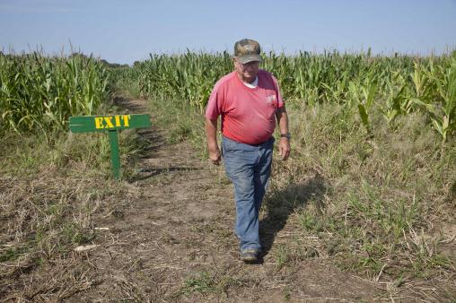
Photo credit above: "
In this photo taken Tuesday, Oct. 2,
2012, farmer Bob Schaefers walks from the exit of a trail through his
corn maze near Lollie, Ark. Devastating spring freezes and this year's
historic drought have taken some of the charm out of rustic fall
destinations, leaving some corn mazes too short for labyrinth duty,
orchards virtually devoid of U-pick apples and fall colors muted." (AP Photo/Danny Johnston)
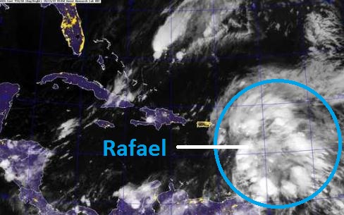
Up To The R's. It's the proverbial "bear in the
woods" dilemma. If a hurricane forms out over open water in the
mid-Atlantic does it still count? Absolutely. Rafael is the newest
tropical storm getting its act together over the Lesser Antilles.
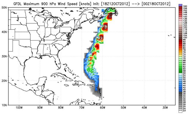
Rafael's Track. Right now it looks like Tropical
Storm Rafael will not pose any risk to the USA, based on GFDL hurricane
model guidance from NOAA. Once again the Canadian Maritimes may see the
soggy, windblown dregs of a somewhat weakened storm by the end of next
week.
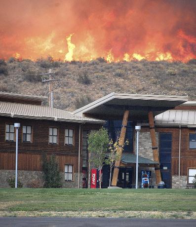
U.S. Runs Out Of Funds To Battle Wildfires. Details from
The Washington Post; here's an excerpt: "
In
the worst wildfire season on record, the U.S. Department of
Agriculture Forest Service ran out of money to pay for firefighters,
fire trucks and aircraft that dump retardant on monstrous flames. So
officials did about the only thing they could: take money from other
forest management programs. But many of the programs were aimed at
preventing giant fires in the first place, and raiding their budgets
meant putting off the removal of dried brush and dead wood over vast
stretches of land — the things that fuel eye-popping blazes,
threatening property and lives..."
Photo credit above: "
Flames roar down the hill toward
Paschal Sherman Indian School shortly after 51 live-in students were
evacuated from the campus six miles from Omak, Wash., on Tuesday, Oct.
2, 2012." (AP Photo/The Omak-Okanogan County Chronicle, Cary Rosenbaum)
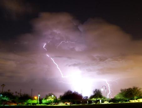
A Wild Sky Above Phoenix. Kudos to Paul Alder for this time-lapse of cloud to ground lightning in the Phoenix area Friday via
Facebook: "
Fall
Thunderstorms from Central Phoenix, Arizona this evening!!!! The cells
were moving quickly to the north, so the clouds look fuzzy, but the
lightning was beautiful!!!"
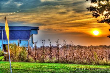
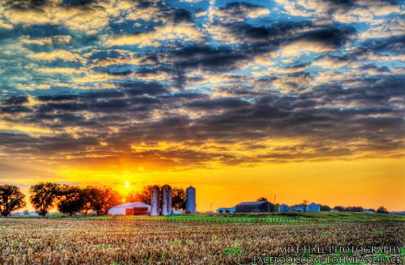
Touch of Disney. Thanks to one very prolific photographer by the name of Mike Hall for sending in this
fabulous photo from Lewisport, Kentucky Friday. Very nice.
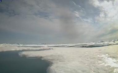
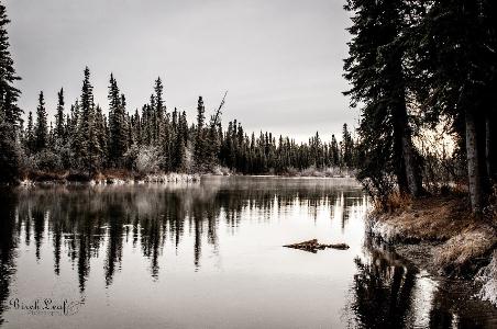
Frosty Start. Just staring at a photo like this one (snapped at Delta Junction Alaska) has a way of lowering my blood pressure. Thanks to
Birch Leaf Photography and WeatherNation TV for sharing this one.
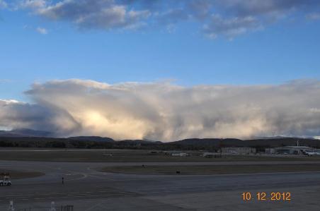
Looks Like Snow Showers. This
photo
comes from the Burlington, Vermont office of the NWS: "Great shot from
the roof of the Burlington International Airport of some snow showers
over the Bolton region.
"Smart Bra" Acts As An Early Warning System For Breast Cancer.
The arc of technology is truly remarkable; new breakthroughs may allow
women (wearing the right bra) to get notification if something isn't
quite right.
Gizmag.com has the story; here's an excerpt: "
We’ve previously seen bras that monitor a wearer’s heart rate, double as an emergency facemask, or help women search for a husband.
But the BSE (breast self exam) bra being developed by First Warning
Systems looks to be the best bit of added functionality for the support
undergarment we’ve come across yet. Using sensors integrated into the
cups, the bra looks for the slight variations in temperature on the
surface of the breast that can indicate a tumor growing within..."
9 Things Not To Wear On A Plane. This caught my eye
(how could it not?) Mea culpa. Men are such simple (borderline pathetic)
creatures. Here's a clip from a visual, laugh-worthy article at
smarttravel.com: "
The
rules of in-flight fashion are different from those on the ground.
When you're sitting for hours in a metal tube flying 35,000 feet in the
air, comfort trumps style. Wear an outfit that keeps you cozy and
relaxed, and you'll likely appear more chic than the traveler struggling
with heavy bags in four-inch stilettos or the one sweating in
too-tight synthetic fabrics. To look and feel your best while
jet-setting, avoid the following in-flight fashion faux pas."
* Photo above: Mike Hall.
What Rain?
You should see my office. It's the one with little dents in the sheet rock - from me banging my big fat head against the wall.
I feel cheated, meteorologically violated.
Here, let me blame the computer models.
The future is never black or white. It's always
some nebulous shade of gray. Our confidence goes up when a). all the
models agree, and b). there is continuity from run to run. Such was the
case earlier this week - but the latest solutions show the heaviest rain
bands (and severe storms) from Iowa into Wisconsin, brushing southeast
Minnesota. We may see a lonely shower, but not the soaking we had hoped
for.
One silver lining: you can stash the heavy
jackets - for now. This soggy southern storm pulls mild air north; highs
top 60 today & Sunday, 70s are likely Monday.
Then it gets interesting. A soggy cold front
Wednesday "cuts off", stalls over the Great Lakes, sending a swirl of
rain, possibly mixed with wet snow, into Minnesota by next Friday.
Slushy lawns in a week? I wouldn't be shocked. In fact very little
surprises me these days.
Long-range models bring more 60s into town the
last week of October. Wait, these are the same models that said it would
rain today.
Buyer beware.
Climate Stories...
 Hottest Year So Far In Philadelphia
. And a large chunk of the USA, for that matter. Here's an excerpt from a story at
philly.com: "
2012 is on pace to be the warmest on record in more than 100 U.S.
towns and cities, including Philadelphia, and for the continental United
States as a whole, according to the National Oceanic and Atmospheric
Administration. Philadelphia has certainly seen some extremes in recent years. 2011
was Philadelphia's wettest year on record, with precipitation equalling
64.33 inches of water. The winter of 2009-10 had the most snow ever,
78.7 inches. For the first nine months of 2012, Philadelphia's average
temperature was 62.2 degrees, 3.5 degrees above the average during the
two decades from 1981 to 2010. The city's record covers the last 65
years..."
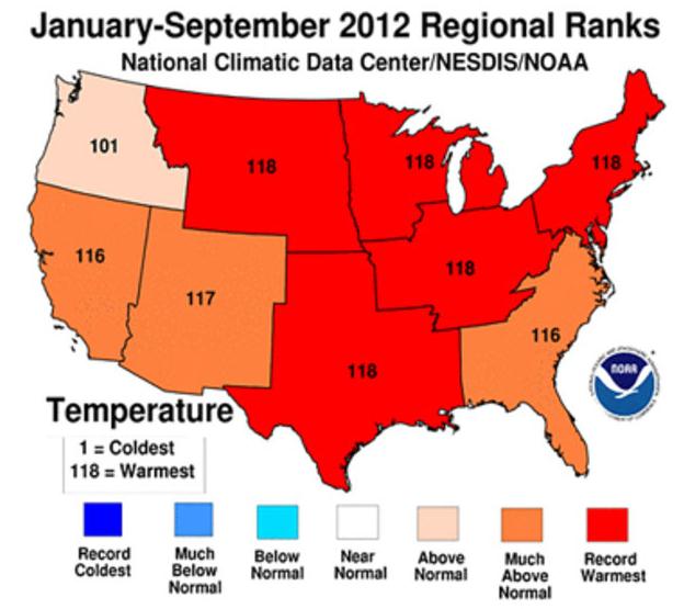
Graphic credit above: "
The continental U.S. had its hottest average temperature in 118 years,
according to federal researchers. Five of eight regions also set records
(in red), while three others had their second or third highest average
temperatures. The Pacific Northwest was also "above normal."
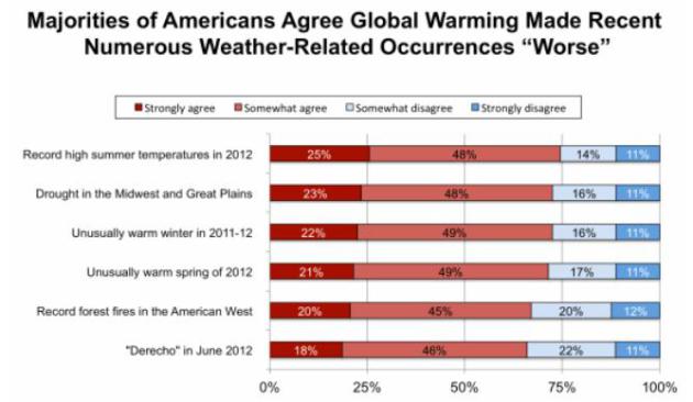 Yale Poll: Large And Growing Majority Of Americans Say "Global Warming Is Affecting Weather In The United States."
 Here's a snippet from a story at
Think Progress:
"
Yet
another survey finds that the public accurately understands global
warming makes extreme weather events worse. This new poll from George
Mason University and Yale’s Project on Climate Change Communication matches the finding of a February Brookings poll
that found Americans’ understanding of climate change was increasing
with more extreme weather and warmer temperatures. Heck, the weather has
been so off the charts that even the major media have taken notice
(see Every Network Gets Extreme Weather Story Right, ‘Now’s The Time We Start Limiting Manmade Greenhouse Gases’ — ABC). And the public’s understanding certainly matches the science (see “Has Global Warming Caused A Quantum Jump In Extreme Weather?” and links below)."
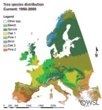
Forests To Feel Climate Change Effect - Damage Could Cost Billions. One
of my fears, one of many, is that these problems with bark beetles and
other pests begin to impact Minnesota's North Woods and the BWCA. I'm
holding my breath, especially after reading this article at
phys.org; here's an excerpt: "
Researchers
from Finland, Germany, the Netherlands and Switzerland believe that
changes in both temperature and precipitation will affect the range of
most tree species. Their estimates were calculated on a wide range of
temperature increases, between 1.4 C and 5.8 C. The anticipate this will
occur even if the climate change scenario is not extreme. Cold-adapted
and mesic species, including Norway spruce, which is the biggest
contributor to the economic value of European forests, will feel the
biggest crunch..."
Image credit above: "
A new pan-European study suggests
that the economic value of forests will decline between 14% and 50% due
to climate change. If measures are not taken to change this, the damage
could reach several hundred billion euros, say researchers led by the
Swiss Federal Institute for Forest, Snow and Landscape Research (WSL) in
Switzerland. The study was presented in the journal Nature Climate
Change."