“
We don’t have many modern precedents for what the models are suggesting....”
- Jim Cisco, NOAA's Hydrometeorological Prediction Center (via the
Associated Press and The Capital Weather Gang). Details below.
Worst Storm in 100 Years for Northeast USA? Business Week speculates
here.
"...
It does worry me that most powerful nation in the world,
North America, denies what the rest of us can see very clearly [on
climate change]. I don't know what you do about that. It's easier to
deny." - Sir David Attenborough, as quote in the U.K. Guardian. Details and links below.
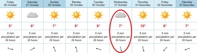
A Quiet Week Ahead. The European ECMWF outlook shows
storm-free weather into the end of next week. Right now Halloween looks
dry and seasonably cool, with highs in the mid 40s, Trick or Treat
temperatures around 40.
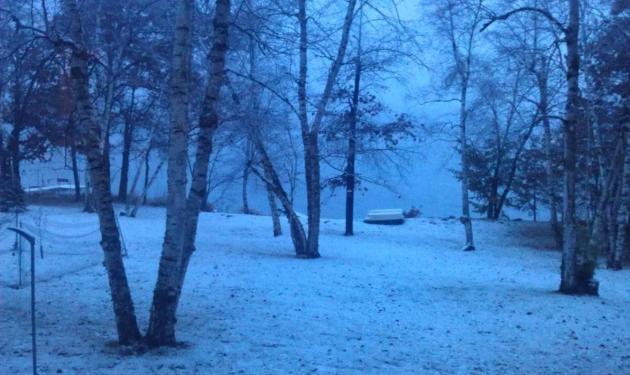
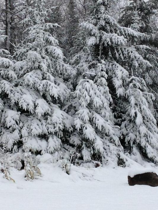
Taste of Winter. Kim Twigg snapped this shot near Crosby Thursday morning - about 1 to 1.5" of snow fell.
Friday Snowfall Amounts:
4.8" reported at Orr, Minnesota
3" Virginia
2.9" Aitkin
1.3" Fort Ripley
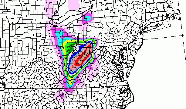
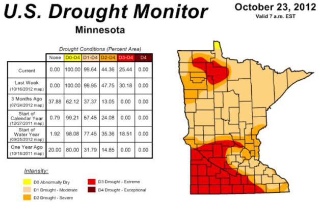 Minnesota Drought Update.
There was some improvement in drought conditions in the last week; the
area experiencing extreme drought shrank from 30 to 25%. But much of the
metro is in severe drought; the .75" of rain that fell yesterday was
welcome indeed, but we still need 6-8" of rain to completely pull out of
the drought in the Twin Cities, as much as 10" over southwestern
Minnesota. Source:
NOAA Drought Monitor.
"Frankenstorm"
Everything is interconnected, in ways we often
don't appreciate. Consider this: the same surge of Canadian air that
sparked slush and wind chill will suck Hurricane Sandy into the
Northeast Monday.
Sandy will impact tens of millions of Americans
over the next 4 days; damage from this hybrid hurricane/Nor'easter will
be extensive, especially north of where the core of this (mutant) storm
comes ashore. Clean-up may take weeks, and I've already gone on record
predicting that Sandy may have an impact on Election Day voter turnout.
This storm reminds me of "Grace" in 1991, which mutated into "The Perfect Storm", thrashing coastal New England.
Landfall? Anywhere from Virginia Beach to
Atlantic City, NJ. Washington D.C. may see significant flash flooding by
Monday. Florida will be grazed tonight, the Outer Banks may see a 5-8
ft. storm surge by Sunday.
Our weather looks like an afterthought by
comparison: partly sunny and 40s over the weekend; the next chance of
rain next weekend. Halloween? Low 40s, probably dry.
If you have friends/family on the east coast
encourage them to pay attention, and consider an evacuation plan - away
from the coast. Stay tuned.
A More Perfect Storm. Sandy Could Make U.S. History. Here's an interesting analysis from Bob Henson at
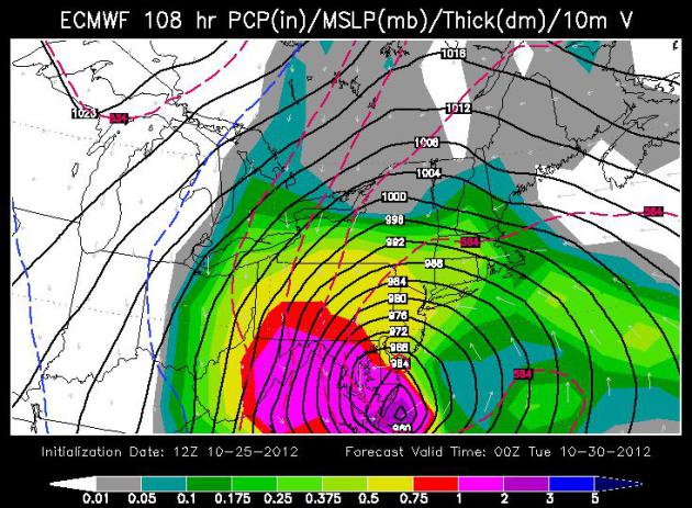
NCAR; an excerpt: "...
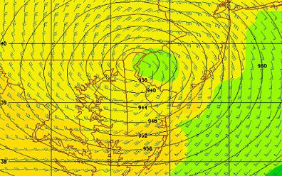
Leading
forecast models are producing spectacularly low pressures at the
center of Sandy. Here are several results from this morning’s 1200 UTC
runs for approximate projected intensity in hectopascals at or near
landfall. Note that 945 hPa is close to 28.00 inches of mercury on a
home barometer."
|
GFDL GHM
ECMWF
NOAA GFS
|
|
928 hPa
936 hPa
944 hPa
|
|
central NJ, Tuesday AM
Delmarva peninsula, Monday PM
Long Island, Tuesday PM
|
"
While a couple of hurricane landfalls in
Florida have produced pressures in this range, most cities in the
Northeast have never reached such values, as is evident in this state-by-state roundup. The region’s lowest pressure on record occurred with the 1938 hurricane at Bellport, Long Island (946 hPa)...."
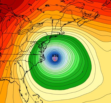
Image credit above: "
This forecast panel from the NOAA Geophysical Fluid Dynamics Laboratory hurricane model
(GFDL GHM), issued at 1200 UTC on Thursday, 25 October, shows
Hurricane Sandy producing record-low barometric pressure near
Philadelphia on Tuesday, 30 October." (Image courtesy NOAA.)
Thursday’s Gusts
Cuba:
Santiago De Cuba - 111.6 mph (12:11 a.m. today)
Guantanamo Bay – 75.8 mph (1:56 a.m. today)
Bahamas:
Nassau – 67 mph (8:31 p.m. today)
Bells Cay – 65.8 mph (5:13 p.m. today)
Florida (rain band squalls):
Miami Beach – 60.7 mph (6:33 p.m. today)
Thursday’s Rain
Bahamas:
Bells Cay – 2.04 inches
Florida:
Hialeah – 2.1 inches
Miami Beach – 1.73 inch
Cuba:
Guantanamo Bay – 3.22 inches (2-day total, 0.47 inch today, 2.75 inch yesterday)
* thanks to Julie Gaddy at Earth Networks for passing these details along.
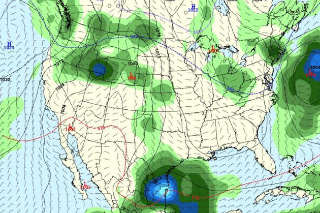
Election Day Weather, 2012. The
long-range GFS outlook shows showery rains over Ohio (a swing state, I
hear) and interior New England, showery rains and mountains snows for
the Northern Rockies and Pacific Northwest - dry weather over much of
the southern USA.
Could “Frankenstorm” Hurricane Sandy Impact the 2012 Elections? It’s Not as Far-Fetched as it Sounds.
Could Hurricane Sandy wind up being the “October Surprise” that political pundits have predicted?
I’m starting to think so. Will even the threat of another Perfect Storm
impact the 2012 Elections, on a local, state and national level?
Research suggests that foul weather may have played a role in the 1960
and 2000 Presidential elections.
In fact a 2007 study at
The Journal of Politics concluded, “…
we
find that, when compared to normal conditions, rain significantly
reduces voter participation by a rate of just less than 1% per inch,
while an inch of snowfall decreases turnout by almost .5%. Poor weather
is also shows to benefit the Republican party’s vote share. Indeed, the
weather may have contributed to two Electoral College outcomes, the 1960
and 2000 presidential elections.”
I’ll stick to trying to
predict the weather, but I won’t be one bit surprised if Sandy’s
aftermath lingers into Election Day, with many residents of the
northeast unable to reach the polls, and a predictable level of
finger-pointing if the electricity is off for an extended period of
time. But based on the size and potential ferocity of this 500 mile-wide
storm it may take weeks for some northeastern towns, especially along
the coast, to get back to anything resembling “normal”.
The biggest lesson from Hurricane Irene last year: don’t underestimate the perils of
inland flooding,
even 24-72 hours after a storm reaches land. The soggy dregs of Sandy
will contain unimaginable levels of moisture, rain that may come down in
sheets from the Shenandoah Valley to the Berkshires of Massachusetts.
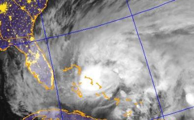
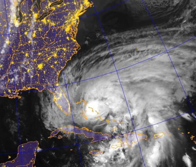
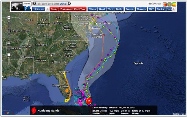
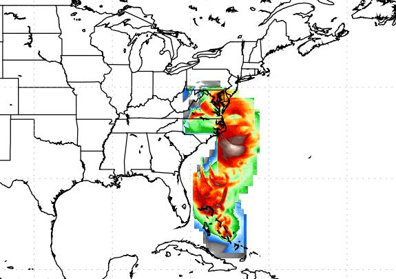
Tonight Hurricane
Sandy is a Category 2 storm, with 100 mph winds, churning north,
northwestward across the Bahamas at 17 mph. The storm will soak Florida
with some 5-10” rains Friday and Friday night, but the core of the
storm, strongest winds (and worst of the storm surge) will remain just
offshore, a near-miss for Miami, West Palm Beach and Jacksonville.
Here is an excerpt of a report I filed this even
for the corporate clients that subscribe to my company’s severe weather
automated alerting and briefing service:
Alerts Broadcaster:
Florida will experience flash flooding and moderate
coastal flooding at high tide tomorrow, but North Carolina’s Outer
Banks won’t be quite as lucky by Sunday, a rejuvenated Sandy, by this
time a hybrid hurricane/Nor’easter, pummeling the barrier islands of
North Carolina with hurricane-force winds and a 4-8 foot storm surge.
The Tidewater Region of Virginia (Norfolk, Virginia
Beach, Newport News) will be impacted Sunday afternoon into Monday
morning, with a potential for significant coastal flooding and beach
erosion.
The latest model run seems to be nudging landfall farther north, closer to Atlantic City later in the day Monday. Keep
in mind that the worst coastal (storm surge) flooding will take place
north of where the eye or center of Sandy comes ashore, as it gets sucked into a larger trough of low pressure approaching the east coast.
Richmond, Washington D.C. and Baltimore may see
extensive 4-10” rains with inland flooding a very real threat early next
week, but the strongest winds (and highest waves) will probably come
from Ocean City, Maryland northward to Cape May and Atlantic City. Sandy
may push a significant dome of water into New York Harbor by Monday,
with extensive flooding along coastal regions of Long Island, from
Southampton to Montauk.
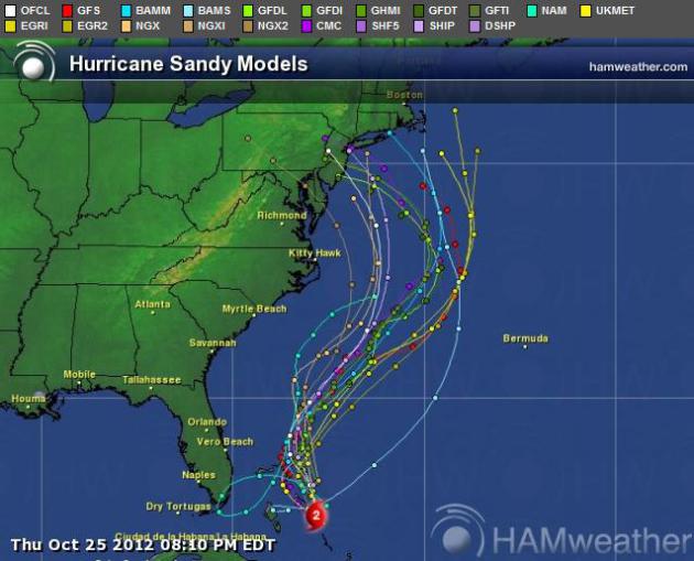
A Close Call for Florida. Most models take Hurricane Sandy
150-200 miles east of Miami and Ft. Lauderdale, although the NAM model
continues to “loop” Sandy directly into south Florida by Friday night.
This is still possible, but you have to go with the majority of models
and the trends, which keep the worst of the winds and waves out to sea.
That said, it will be a very close call, with a potential for
significant flash flooding across much of the Sunshine State. Map: Ham
Weather.
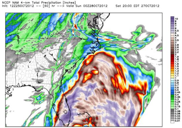
Florida Flash Flood Potential. The highest-resolution 4 km.
NAM model is hinting at some 5-10” rains from Daytona Beach and The Cape
southward to Naples and Miami over the next 60 hours. Although the core
of strongest winds and highest surf will pass east of Florida, the risk
of problems from inland flooding is considerable. Map courtesy of
Weather Bell.
Model Trends. Here is one map, courtesy of NHC and
Ham Weather,
which shows all the various model tracks. Meteorologists look for
continuity from model run to model run, and we examine the trends. Are
the models adjusting the track farther north or south over time? Right
now the general consensus is for the models to nudge Sandy’s track
slightly north, closer to Wildwood and Atlantic City by Monday, but
coastal residents from Virginia Beach to Cape Cod need to stay alert. We
expect the track to change several times, as new data initializes the
computer models. Hopefully these simulations will converge around a
similar solution as we get closer to landfall early next week.
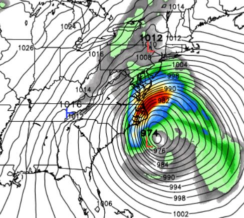
A Rough Sunday For The Outer Banks. Here is the NAM solution
for midday Sunday, hinting at hurricane force wind gusts for the Outer
Banks of North Carolina, as well as Norfolk and Virginia Beach, with
flooding rains overspreading Virginia’s Tidewater.
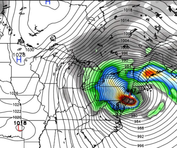
Solution #1. The ECMWF (European) model brings the center of
Sandy, by then a “Frankenstorm”, a hybrid hurricane/Nor’easter, close to
Ocean City, Maryland by Monday evening. This would imply the worst
storm surge flooding and highest winds for points north of the eye or
center of the storm, from Bethany Beach and Rehoboth, Delaware into
coastal New Jersey. The ECMWF was the first model to “hook” Sandy
inland, back on Monday of this week, so I tend to put a little more
stock into the ECMWF solution than most of the other models. Flooding
rains are likely 100-250 miles inland, with potentially serious flash
flooding likely from Roanoke and Richmond into Washington D.C. and
Baltimore Sunday night into Tuesday. Map: WSI Corporation.
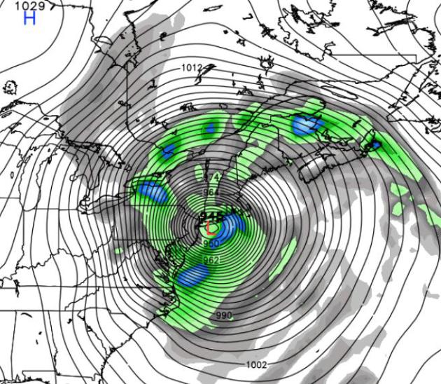
Solution #2. The Navy NOGAPS model shows a similar solution,
although farther north, with possible landfall Monday morning over New
Jersey. The farther north Sandy comes ashore, the greater the threat to
not only New Jersey but metropolitan New York City and Long Island. A
long “fetch” over the Atlantic may result in a storm surge 5-15 feet
above normal, with the greatest threat of coastal flooding and beach
erosion over the southern coastline of Long Island eastward to
Providence, Martha’s Vineyard, Nantucket and Cape Cod. Map: Weather
Bell.
Solution #3. The GFS model is coming into alignment with the
Navy NOGAPS solution, suggesting a more northern track, one that would
threaten New York City, Long Island, Groton, Providence and Cape Cod
with the largest storm surge and most widespread coastal flooding. If
this forecast verifies, still a big if, metro New York could see
hurricane-force winds during the day Monday.
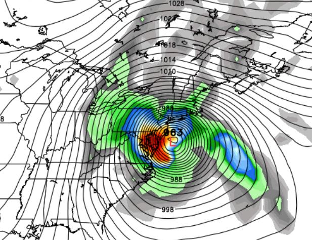
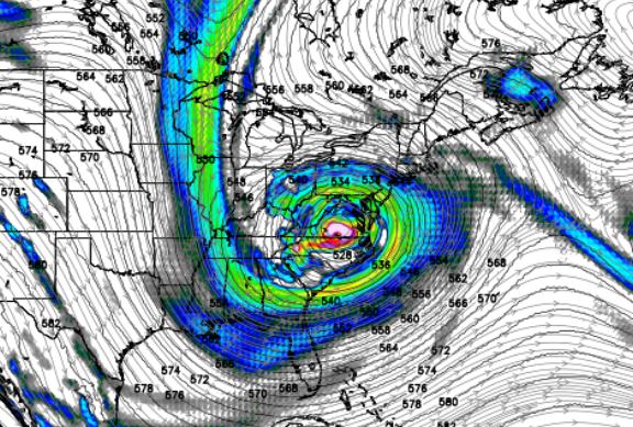
Solution #4. Lights out for The Big Apple? The Canadian (GEMS)
model shows a direct strike on Long Island and New York City, with
hurricane force gusts from Baltimore to Hartford, Worcester and
Providence. The map above is valid 1 am Tuesday. Again, I’m struck by
the sheer size of this storm.
One of my meteorological pet peeves is when the
forecaster gives a dozen scenarios, which leaves viewers or readers more
confused than ever. What’s going to happen? Odds still (strongly) favor
that a hybrid storm will come ashore early next week. Monday looks like
the worst day, but Sunday and Tuesday will be nearly as rough, in terms
of winds, waves and inland flooding across the Mid-Atlantic and
southern New England. Right now I suspect New Jersey is Ground Zero for a
direct strike, but this could shift anywhere from Ocean City, Maryland
to Providence. I’m leaning toward Scenario #2 above. If Sandy does
strike near Atlantic City Monday night, even if it’s not a warm-core
hurricane, a long-lasting fetch of high winds over the Atlantic may
build up a towering 8-15 foot storm surge, especially north of where
Sandy comes ashore, which would increase the threat of lowland flooding
for New York City and the southern coastline of Long Island.
What’s a “Frankenstorm”? A hybrid
hurricane/Nor’easter, similar to what happened on Halloween, 1991, when
moisture and energy from a decaying Hurricane Grace fueled “
The Perfect Storm”,
a massive super storm that thrashed New England with hurricane-force
winds. Technically the 1991 storm was a cold core storm, not a
hurricane, but if it can sink your boat or take the roof off your house,
it becomes a matter of semantics: hurricane or extreme Nor’easter? At
some point it doesn’t matter if winds are roaring a hurricane force.
Summary: Florida will be spared the worst of
Sandy’s wrath, but extensive flooding is likely along the Outer Banks
of North Carolina, from Wrightsville Beach northward to Cape Hatteras,
Duck and Corolla, on Sunday. I’m worried about lowland flooding in
Virginia Beach and Norfolk late Sunday into Monday as well.
If anything the models are nudging landfall slightly north,
closer to Atlantic City, which poses a greater risk to metro New York
City and Long Island, as well as Providence and Cape Cod. Serious inland
flooding is still expected Sunday night into Tuesday from Norfolk to
Washington D.C. to Philadelphia and New York. Again, Sandy is a huge
storm, and even though it may lose some of its hurricane-like
characteristics, it will still deliver hurricane-force winds when it
comes ashore early next week.
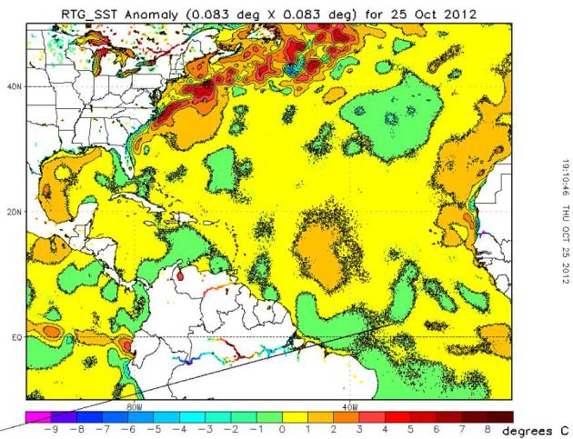
Mitigating Factor: Unusually Warm Gulf Stream Waters.
Sea surface temperatures (SST) are running as much as 5-8 F. warmer
than average in the Gulf Stream, just off the east coast. This warm
stain of water may help to sustain hurricane strength unusually far
north (for late October). Map: NOAA.
The 1% Is Nervous. At least the 1% of Americans who happen to have estates on the south shoreline of Long Island.
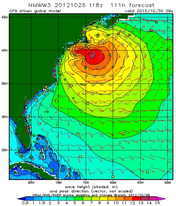
NOAA NCEP is predicting some 12-13 foot waves by Monday and Tuesday from near Cape Cod to New York Harbor.
Experts Sound Alarm On Hurricane Sandy, Like To Be Worse Than 1991 "Perfect Storm".
Here's a snippet of an interesting story (providing some much-needed
perspective) from meteorologist Jason Samenow, writing for The
Washington Post's
Capital Weather Gang: "...“
The Perfect Storm deepened to 972 mb...” Why Sandy could be more powerful, Will Komaromi:
“Most of the models now indicate even stronger jet dynamics will occur
next week than occurred during for the Perfect Storm, and that today’s
storm could potentially deepen to well below 960 mb or even below 950
mb. The fact that the Gulf Stream is anomalously warm for this time of
year means that Sandy will weaken less as a tropical system...” Sandy will be worse, Jeff Masters:
“The Perfect Storm only did $200 million of damage and I’m thinking a
billion.Yeah, it will be worse.”(via the Associated Press)..."
Evidence Mounting For Historic Storm To Strike The Northeast. Here's an excerpt of a good post from
Accu Weather meteorologist Joe Lundberg: "
The
weather from central and East Texas to the Florida Panhandle up to the
Great Lakes is nothing short of stunning today. There is a lot of
sunshine at this very hour, temperatures more reflective of early
September, if not late August, and there's seemingly not a care in the
world! Yet, it has turned much colder overnight down into the Texas
Panhandle behind a strong cold front. Snow accumulated a few inches
around Denver and Boulder overnight, and a wind-driven cold rain is
mixing with snow as I write this in the suburbs of Minneapolis.
Meanwhile, on the southeast coast of Florida, winds are gusting to 30
miles an hour with bands of rain rotating through on northwest flank of
Sandy, a strong hurricane that only lost some of her punch in crossing
Cuba early today. The cold front coming across the Plains and Sandy
coming out of the Caribbean appear to be on somewhat of a collision
course that many now agree could lead to an historic storm early next
week...."
A Snowy Hurricane? Bitter air surging eastward will
create the temperature contrast and high-level jet stream wind
configuration necessary to intensify "Sandy" into a super storm, a
massive Nor'easter capable of beach erosion and coastal flooding.
Inland, enough cold air may be in place for a foot of snow for the
mountains of West Virginia. GFS forecast courtesy of NOAA and
Weathercaster.
What Are The Best Stories About People Randomly Meeting Steve Jobs? A friend e-mailed me this link from
quora.com; here's an excerpt: "
I'm
particularly curious to know what he was like outside of Apple Inc. He
had a reputation for being "difficult" to work with, or work for. I
want to know about what he was like as "the guy buying coffee...", or
"the customer who stopped into an Apple Store..."
"I dated for years a young woman
whose father was Steve Jobs' neighbor in Palo Alto. I thus found myself
in the neighborhood often, at dinners, or parties, etc. We would see
the Jobs come and go – they have a “normal” house, no gates, no guards,
no high fences, not even a big lot. Often, leaving a party at my
girlfriend’s house late at night I would drive past their house and you
would actually see Steve sometimes, working on a Mac."
Weather History for October 25, courtesy of the Twin Cities NWS:
1996: An unusual outbreak of
severe occurred across north central Minnesota. Intense low pressure
tracking into Minnesota produced blizzard conditions over portions of
South Dakota, while further east in Minnesota, unseasonably mild
temperatures developed. Temperatures climbed near 70 with dew points in
the 50s. 1 to 1 3/4 inch hail and strong winds were reported in Lac Qui
Parle, Yellow Medicine, Chippewa, and Swift Counties. These storms
produced 12 tornadoes, the largest reported were F2s. Southwest of
Alexandria in Douglas County, an F2 tornado with a 9 mile track
destroyed several homes. One women sustained broken bones and internal
injuries when a portion of her house, with her inside, was flung 200
feet onto the interstate. This tornado also pushed over a 500 pound
fuel tank. Tornadoes also touched down in Swift, Kandiyohi, Pope,
Stearns, and Isanti Counties.
1985: Indian Summer across Minnesota. Twin Cities hits 70.
* photo above courtesy of Tami Sallis in Hibbing.
Climate Stories...
Romney, Obama Avoid Climate Change Stigma, Waste Air. Here's an excerpt of a timely Op-Ed at
Bloomberg Businessweek: "
The
cringe-inducing catfight about oil drilling in the second presidential
debate reminded us how carefully both candidates have avoided the topic
of climate change. Those two words weren’t mentioned once, unlike “gas”
(30 times). The candidates touched on oil and gas policy in the third
debate, but without voicing any concerns about the fact that fossil
fuels produce greenhouse-gas emissions. That’s because well-financed
voices with a big stake in America’s wasteful status quo have
successfully stigmatized global warming..."
Photo credit above: "
A courtyard view of the Kohler
Environmental Center at Choate Rosemary Hall in Wallingford,
Connecticut. To achieve net-zero energy use, the building uses natural
ventilation and controlled use of daylight and shade. Solar panels have
been installed on the roof." Photographer: Peter Aaron/Robert A. M. Stern Architects via Bloomberg
David Attenborough: U.S. Politicians Duck Climate Change Because Of Cost. Here's an excerpt from a story at
The Guardian: "...
Asked what was needed to wake people up, the veteran broadcaster famous for series such as Life and Planet Earth
said: "Disaster. It's a terrible thing to say, isn't it? Even disaster
doesn't do it. There have been disasters in North America, with
hurricanes and floods, yet still people deny and say 'oh, it has nothing
to do with climate change.' It visibly has got [something] to do with
climate change." But some US politicians found it easier to deny the
science on climate change than take action, he said, because the
consequence of recognising the science on man-made climate change "means
a huge section from the national budget will be spent in order to deal
with it, plenty of politicians will be happy to say 'don't worry about
that, we're not going to increase your taxes..." Photo: Clean Technica.
Frontline: Did The Climate Deniers Win? Here's an excerpt of a Chris Mooney story at
Mother Jones: "
On Tuesday Night, PBS's Frontline aired an hour-long special
on the climate saga over the past four years—focused centrally on the
skeptics themselves, whom PBS's John Hockenberry depicts as victorious
in stopping any policy action. Touring Heartland Institute conferences,
hearing plentiful sound bites from the Competitive Enterprise
Institute's Myron Ebell,
we learn that these folks are basically high-fiving right now as the
presidential campaigns studiously ignore the climate issue. And yes,
they really do think the science is on their side, and that they're
winning on the intellectual merits. Not that Hockenberry agrees—one of
the gems of "Climate of Doubt" is a deft explanation of how climate
skeptics come up with the bizarre assertion that the planet hasn't been
warming lately. As NASA's Gavin Schmidt nicely explains to
Hockenberry, all you have to do is go back over the noisy temperature
record and "pick the endpoints" of your analysis—and you can promptly
uncover numerous temporary cooling periods. "But actually, the whole
thing has been moving up," Schmidt explains—warming over the course of
many decades..."
Global Warming And Allergies. Here's a snippet from a story at
about.com: "
Global warming
is a hot-button issue in today’s political environment. Some say that
global warming, due to the man-made increases in greenhouse gases, is
responsible for melting the polar ice caps and warming the oceans—the
result being freakish weather patterns such as hurricanes and tsunamis,
all referred to as climate change.
Others say that climate change is an inevitable cycle that the earth
goes through every thousands to millions of years, and that it has
nothing to do with the actions of man. Regardless of your philosophy or
political affiliation, there are definite changes to the earth’s
climate, which may in part be responsible for the significant increase
in allergic diseases in the past few decades..."
Antarctic Runway Succumbs To Global Warming. Here's a story I tripped over yesterday, courtesy of
The Oman Observer: "
Australia
yesterday said it was searching for a new aircraft landing site for
planes supplying its three bases in Antarctica because the current
runway is melting. Australia has three stations on the icy continent —
Casey, Davis and Mawson — occupied by scientists and support staff,
with the Wilkins runway, carved into glacial blue ice, a vital
transport link. But a melting surface has started to restrict use of the
Aus$45 million (US$46.4 million) landing strip near Casey and the
Australian Antarctic Division said they were looking at alternatives.
They include the ice-free Vestfold Hills near Davis. “During the first
few years since the introduction of Australia’s airlink to Antarctica
in 2007/08 our operations have, on occasions, been hampered by glacial
melt at the current Wilkins runway,” a spokesperson said..."