Warmer than average temperatures predicted thru
December for much of the USA east of the Rockies.
Source: NOAA CPC. Details below.
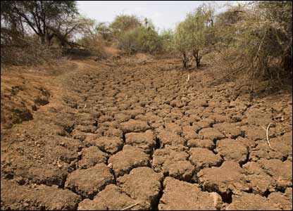
Close Call. Saturday's storm took a hard right turn,
dumping some .5 to 1"+ rainfall amounts on Wisconsin, just brushing far
southeastern Minnesota with .1 to .2" of rain. Our drought continues to
get worse. Map:
NOAA.
17 named storms in the Atlantic so far in 2012. The latest on "Rafael" below.
3rd warmest summer on record for the USA. Source: NOAA NCDC.
"...
Around the world, "the incidence of drought is consistent
with what the climate models are predicting," said John Seinfeld, an
atmospheric researcher at Caltech. "It certainly doesn't appear to be
out of line to conclude that this last summer could be statistically
attributed to global warming." - from a Los Angeles Times story, full details below.
"...
One of the problems with climate change has always been that
it was distant and remote, “but this year weather made it immediate.”
As extreme weather ravaged the majority of the United States this
summer, people who once doubted global warming are now seeing first
hand the wrath climate change can impose on their daily lives and their
wallets..." - from a story at Climate Science Watch, links below.
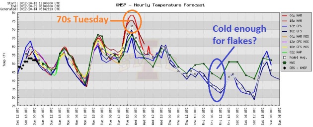
Indian Summer, Then A Cold Slap. Temperatures hold
in the 50s today, surge into the 60s tomorrow before peaking in the 70s
Tuesday, the warmest day in sight. Rain arrives Wednesday with a colder
surge, Canadian air that may spark a few wet flakes by Thursday night or
Friday morning. Graph above: Iowa State.
Some Rain In The Outlook. After Saturday's rainfall
bust I'm a little gun-shy and skeptical, but the ECMWF prints out rain
Wednesday into Friday, followed by a clearing trend next weekend.
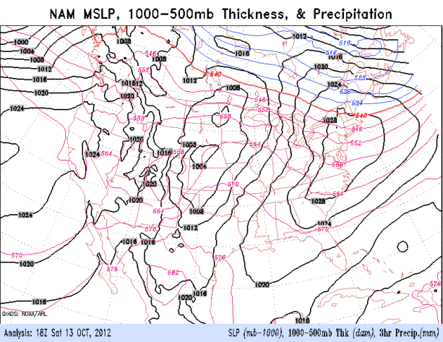
84-Hour Outlook. A wave of low pressure ripples
northeastward across the Ohio Valley and Great Lakes today, a
significant warming trend over the nation's midsection early this week,
before cold air pushes south the latter half of the week. NAM model
courtesy of NOAA.
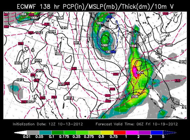
Cold Pool. The ECMWF solution shows a storm "cutting
off" from the main westerlies Thursday night - an unusually cold
whirlpool of air directly above Minnesota. Who cares? With the freezing
level close to the ground a little wet snow could survive the trip to
the ground. Air temperatures should stay above 32 F, so even if we see a
few hours of wet snow odds are it won't stick, at least not on the
metro area. Map above: WSI Corporation.
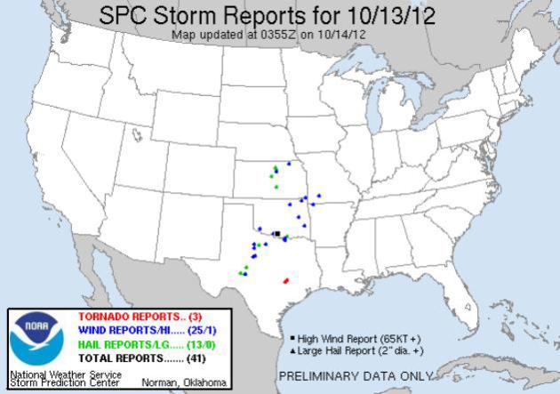
Saturday Severe Storm Reports.
The outbreak wasn't as bad as previously feared: 3 confirmed tornadoes
east of San Antonio, with hail and damaging winds into Missouri and
Kansas. Details from
SPC.
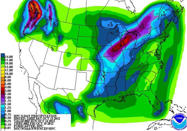
We Just Can't Buy A Storm.
NOAA HPC is predicting some 2-3"+ rainfall amounts from the Quad
Cities, Chicago and Milwaukee into Lower Michigan. Over 4" of rain may
soak the Seattle - Tacoma area over the next 5 days, while dry weather
persists over the southwest.
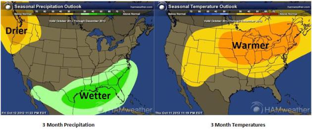
Very Extended Outlook. Based on a weak El Nino, NOAA
CPC is predicting a wetter October thru December for the far southern
USA, drier than average weather expected for the Pacific Northwest. Much
of the USA east of the Rockies is forecast to experience a warm bias
thru the end of 2012. Place your bets. Maps above:
Ham Weather.
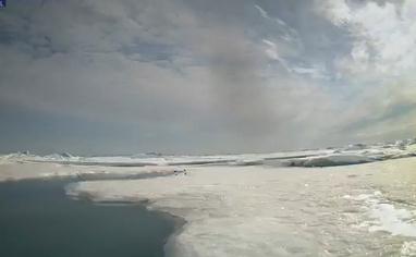
“
We only have so many major physical features on the planet, four
or five, and you don’t really want to just start breaking them. That’s
why we can’t have nice things.” - 350.org enviromentalist Bill
McKibbon, appearing on HBO's "Real Time with Bill Maher". Check out one
of the more important video clips you'll watch this year, a 12 minute
interview from
grist.org. Image: NOAA/PMEL
Expected Rain A Drop In Bucket. Amen to that. Bill McAuliffe at
The Star Tribune summarizes the state of our drought, and (growing) impact on lake and river water levels statewide; here's an excerpt: "...
Across
Minnesota, meanwhile, rivers and lakes are gasping. The St. Louis
River near Scanlon, which rose to a record height in June and tore
apart Jay Cooke State Park, was at what appeared to be its
second-lowest height in more than 60 years Wednesday. The Minnesota
River at Jordan was down to one-seventh of its historical average for
the date. State rivers are contributing so little to the Mississippi
that three-fourths of the water in the river downstream from La Crosse
is now from the Wisconsin and Chippewa rivers, according to Steve Buan,
hydrologist with the North Central River Forecast Center, an NOAA
agency based in Chanhassen. And Lake Minnetonka has dropped 1.5
feet since late June. The low rivers could mean problems later, Buan
said. Lack of flow allows logs and other debris to pile up, and can
create obstructions when the water rises..."
Photo credit above: "
Eden Valley farmer Tom Haag emptied
corn into a holding wagon used to shuttle the grain to a nearby
semi-trailer for transport back to the farmstead and a storage
container." Jim Gehrz, Star Tribune.
A Warm, Dry Bias. Here is an excerpt of this week's
WeatherTalk blog
from Mark Seeley: "This week NOAA also released a summary of national
climate conditions during September. Nationally it was the 23rd
warmest September on record, and the 16th consecutive month with above
normal temperatures. It was also a dry month, with near record setting
low statewide values for monthly precipitation in Minnesota, Montana,
North Dakota, and South Dakota. For the 2012 year so far the period
from January to September has been the warmest first nine months in the
USA climate records nationally. You can read more at
http://www.ncdc.noaa.gov/sotc/national/2012/9
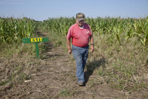
Photo credit above: "
In this photo taken Tuesday, Oct. 2,
2012, farmer Bob Schaefers walks from the exit of a trail through his
corn maze near Lollie, Ark. Devastating spring freezes and this year's
historic drought have taken some of the charm out of rustic fall
destinations, leaving some corn mazes too short for labyrinth duty,
orchards virtually devoid of U-pick apples and fall colors muted." (AP Photo/Danny Johnston)
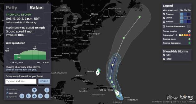
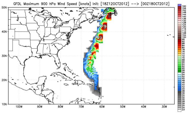
Tropical Storm Rafael Forms In Atlantic.
NBCNews.com has the details: "
After
forming Friday night, Tropical Storm Rafael was dumping rain across
the Less Antilles in the eastern Caribbean on Saturday. Up to 5 inches
of rain was expected, with a few spots potentially at 10 inches, making
for flood and mudslide conditions, the U.S. National Hurricane Center
said. Rafael, the 17th named storm of the Atlantic hurricane season,
will pass near or over the Virgin Islands Saturday night and eventually
accelerate northward..."
Rafael's Track. Right now it looks like Tropical
Storm Rafael will not pose any risk to the USA, based on GFDL hurricane
model guidance from NOAA. Once again the Canadian Maritimes may see the
soggy, windblown dregs of a somewhat weakened storm by the end of next
week.
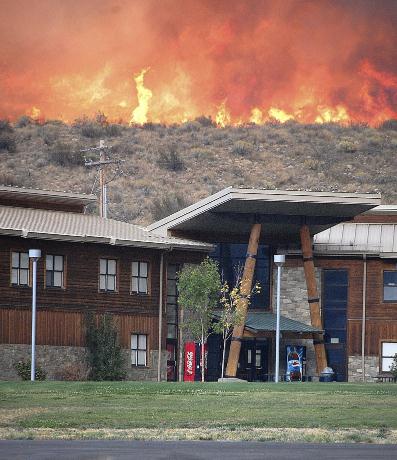
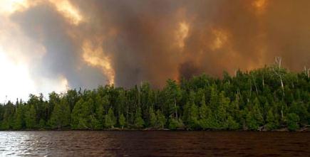
U.S. Runs Out Of Funds To Battle Wildfires. Details from
The Washington Post; here's an excerpt: "
In
the worst wildfire season on record, the U.S. Department of
Agriculture Forest Service ran out of money to pay for firefighters,
fire trucks and aircraft that dump retardant on monstrous flames. So
officials did about the only thing they could: take money from other
forest management programs. But many of the programs were aimed at
preventing giant fires in the first place, and raiding their budgets
meant putting off the removal of dried brush and dead wood over vast
stretches of land — the things that fuel eye-popping blazes,
threatening property and lives..."
Photo credit above: "
Flames roar down the hill toward
Paschal Sherman Indian School shortly after 51 live-in students were
evacuated from the campus six miles from Omak, Wash., on Tuesday, Oct.
2, 2012." (AP Photo/The Omak-Okanogan County Chronicle, Cary Rosenbaum)
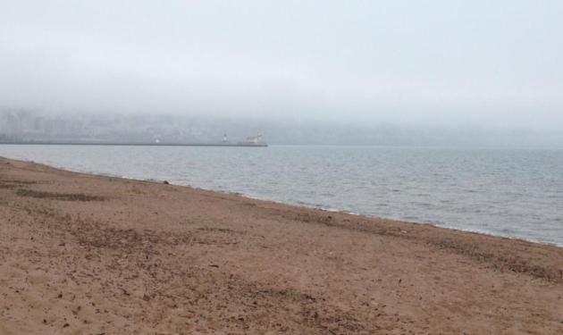
Taking In The Duluth Skyline. Walt Kruhoeffer sent
in this photo of the lakefront. The skyline is there...somewhere. 45 F
with drizzle in Duluth yesterday. In Duluth they call this a "warm
front."
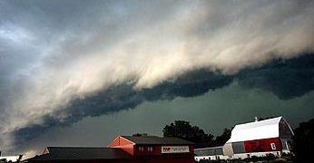
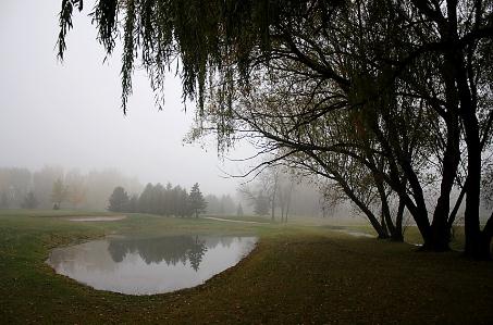
Savoring A Rainy Saturday. The Twin Cities just got
brushed by some very light rain - heavier amounts fell south and east.
Brad Birkholz snapped this photo near Neenah, Wisconsin yesterday.
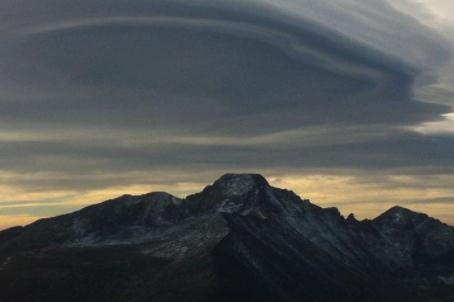
"Lenticularis". These massive wave clouds are formed
when air is forced up and over mountain ranges in a stable environment,
where temperatures warm with altitude. The result: smooth, lens-shaped
clouds, which are sometimes mistaken for UFO's! This
fine specimen is from Rocky Mountain National Park: "
Lenticular clouds, although beautiful, indicate that strong winds are present over the Fern Lake Fire today."
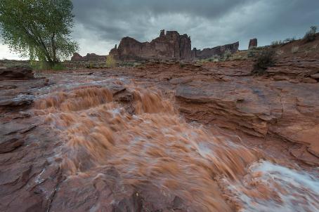
Muddy Rapids. Here's another terrific shot, this time of The Lower Park Avenue Falls at
Arches National Park.
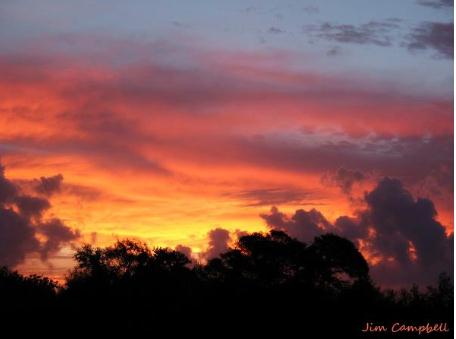
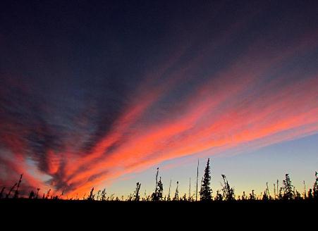
Red Sky At Night. Thanks to Jim Campbell and the
Brownsville office of the National Weather Service for sharing this one.
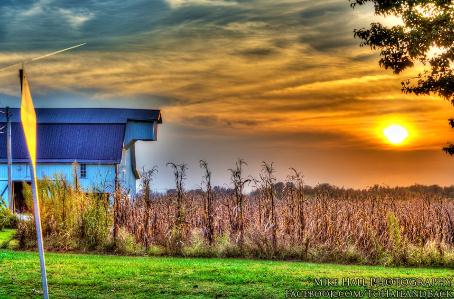
Touch of Disney. Thanks to one very prolific photographer by the name of Mike Hall for sending in this
fabulous photo from Lewisport, Kentucky Friday. Very nice.
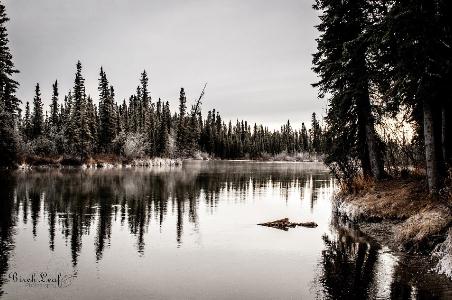
Frosty Start. Just staring at a photo like this one (snapped at Delta Junction Alaska) has a way of lowering my blood pressure. Thanks to
Birch Leaf Photography and WeatherNation TV for sharing this one.
One Antidote to Winter
I remember poking fun at snowbirds when we moved
to Minnesota in '83. Why would anyone do that? Today, at the ripe age
of 54, I see the wisdom of having a southern destination, especially for
the most unnecessary month of the year: February.
My advice? Try
vrbo.com.
Home ownership sounds great, but renting is so much easier. A week, a
month, the winter - you'd be amazed. Trust me on this. When you book a
hotel you're a tourist. When you rent a house you're treated as a local.
Big difference. If you want Florida sand without the traffic consider
Seaside or
Boca Grande.
Even an average winter will feel like a slap
across the face, after last year's Memphis-like 22 inches of slush and
70s in March.
This winter? Probably warmer than normal, based on the trends, but not as easy as last winter.
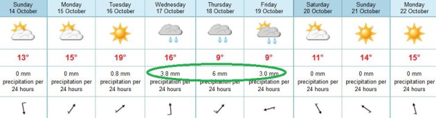
Headlines include a deepening drought and a
Jekyll & Hyde pattern. The sun reappears today; highs near 60. 70
isn't out of the question Monday & Tuesday.
A deepening storm pulls cold air into Minnesota
late week; Wednesday rain mixes with a few flurries by Thursday night.
60s return the last week of October.
Anxious about the winter to come? Consider renting a warm front or two!
Climate Stories...
Northeastern Minnesota Experiment To Study Effects Of Climate Change. The details in a story at
Northland's NewsCenter; here's an excerpt: "...
Funded
by the U.S. Department of Energy, the project is a collaborative
effort between the USDA Forest Service and Oak Ridge National
Laboratory, which is located in Tennessee. Once up and running, the
experiment will slowly heat 12 to 16 transparent chambers, which will
be about 30 feet tall and 40 feet in diameter. The scientists will
slowly heat the chambers to various temperatures, measuring how the
entire ecosystem, from soil to treetops, responds to elevated
temperatures and carbon dioxide levels. "This tower resides in the
center of those chambers and represents the means by which we can
document how warm our little plot of ecosystem has become," said Oak
Ridge National Laboratory researcher, Paul Hanson, of a large tower,
waiting to be placed in the area where the chambers will eventually be..."
Some Climate Scientists, In A Shift, Link Weather To Global Warming. Details from the
L.A. Times; here's a clip from the main story: "...
Extreme
events like drought, heat waves, intense rainfall, flooding and fires
have prompted many people to reconsider the connection between the
weather and the changing climate. Now, a handful of scientists are
among them. In a break with the mainstream scientific consensus, a few
prominent climate scientists now argue that there have been enough
episodes of drought and intense heat in the last 10 years to establish a
statistical pattern of extreme weather due to global warming..."
Researchers Find Link Between Arctic Meltdown And Summer Floods And Fires. The story from Climatewire and
Scientific American - here's an excerpt: "
A new weather
pattern that sends blasts of warm southern air into the Arctic each
June has fueled the recent, dramatic decline of the region's sea ice,
according to a new government-funded study. But that is not all it has
done, the analysis suggests, linking the shifting summer winds to
record thaws of the Greenland ice sheet, unusually wet European summers
and Rocky Mountain wildfires. Researchers say the switch from light,
variable east-west winds to stronger, warmer blasts of southern air
appears to have strengthened a climate feedback loop they call "Arctic
amplification."
Climate Change: Winning Issue Or Losing Battle?
Notice how neither President Obama or Gov. Romney is talking much about
climate change, and their plans to grow the economy without making the
warming, and subsequent extreme weather, that much worse by increasing
our dependence on fossil fuels.
Climate Science Watch has the story; here's a clip: "
Recent, fascinating, and underutilized national polls (also here and here) suggest climate change can be a winning issue in the 2012 elections. A panel of experts, hosted by Climate Desk,
discussed these key questions in Washington, DC, on October 10: With
this recent polling data, why are the President and other political
leaders still not talking about climate change? How can effective
communication between political leaders and the public be stimulated?
Betsy Taylor, President of Breakthrough Strategies & Solutions
and well-known driving force in numerous public interest
organizations, confirmed that climate change has been stifled from
public discourse. In the spring of 2009, after the financial crisis
had hit, “there was a decision made,” Taylor says, “to not talk about
climate change that was adopted by the majority of the environmental
groups and the White House. I was at that meeting.” Reluctantly, the
environmental organizations agreed, while some argued this decision
would come back to “haunt” them. They were right about climate change
haunting us, though the public discourse remains dysfunctional."
Hottest Year So Far In Philadelphia. And a large chunk of the USA, for that matter. Here's an excerpt from a story at
philly.com: "
2012
is on pace to be the warmest on record in more than 100 U.S. towns and
cities, including Philadelphia, and for the continental United States
as a whole, according to the National Oceanic and Atmospheric
Administration. Philadelphia has certainly seen some extremes in recent
years. 2011 was Philadelphia's wettest year on record, with
precipitation equalling 64.33 inches of water. The winter of 2009-10
had the most snow ever, 78.7 inches. For the first nine months of 2012,
Philadelphia's average temperature was 62.2 degrees, 3.5 degrees above
the average during the two decades from 1981 to 2010. The city's
record covers the last 65 years..."
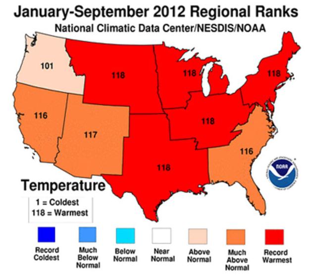
Graphic credit above: "
The continental U.S. had its
hottest average temperature in 118 years, according to federal
researchers. Five of eight regions also set records (in red), while
three others had their second or third highest average temperatures.
The Pacific Northwest was also "above normal."
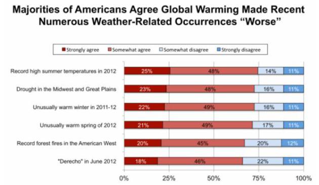
Yale Poll: Large And Growing Majority Of Americans Say "Global Warming Is Affecting Weather In The United States." Here's a snippet from a story at
Think Progress: "
Yet
another survey finds that the public accurately understands global
warming makes extreme weather events worse. This new poll from George
Mason University and Yale’s Project on Climate Change Communication matches the finding of a February Brookings poll
that found Americans’ understanding of climate change was increasing
with more extreme weather and warmer temperatures. Heck, the weather has
been so off the charts that even the major media have taken notice
(see Every Network Gets Extreme Weather Story Right, ‘Now’s The Time We Start Limiting Manmade Greenhouse Gases’ — ABC). And the public’s understanding certainly matches the science (see “Has Global Warming Caused A Quantum Jump In Extreme Weather?” and links below)."
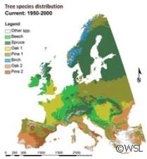
Forests To Feel Climate Change Effect - Damage Could Cost Billions. One
of my fears, one of many, is that these problems with bark beetles and
other pests begin to impact Minnesota's North Woods and the BWCA. I'm
holding my breath, especially after reading this article at
phys.org; here's an excerpt: "
Researchers
from Finland, Germany, the Netherlands and Switzerland believe that
changes in both temperature and precipitation will affect the range of
most tree species. Their estimates were calculated on a wide range of
temperature increases, between 1.4 C and 5.8 C. The anticipate this will
occur even if the climate change scenario is not extreme. Cold-adapted
and mesic species, including Norway spruce, which is the biggest
contributor to the economic value of European forests, will feel the
biggest crunch..."
Image credit above: "
A new pan-European study suggests
that the economic value of forests will decline between 14% and 50% due
to climate change. If measures are not taken to change this, the damage
could reach several hundred billion euros, say researchers led by the
Swiss Federal Institute for Forest, Snow and Landscape Research (WSL) in
Switzerland. The study was presented in the journal Nature Climate
Change."