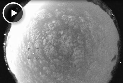
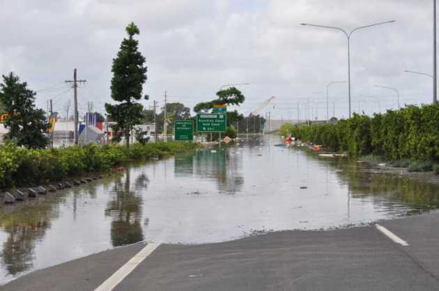
Wild Storms. WeatherNation TV's Lori Ryan snapped
the photo in the upper left Thursday morning, after the rare morning
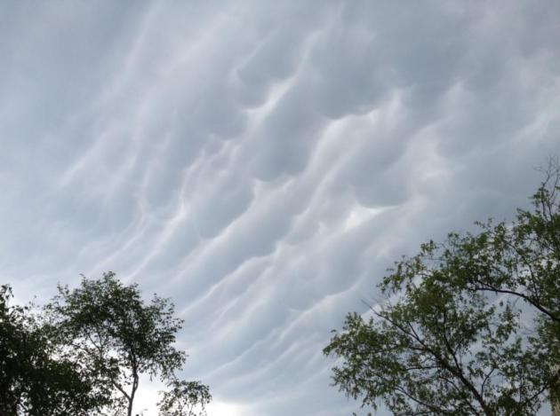
deluge. Meteorologist Addison Greene captured a great photo of
cumulonimbus mammatus (upper right) as the thunderhead anvils swept
overhead.
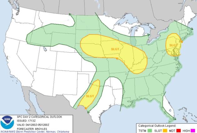
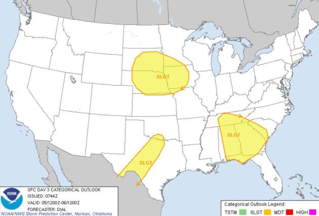
Severe Threat. SPC
is predicting a slight risk of severe storms from South Dakota and
southwestern Minnesota, across much of Iowa - southeast to Indianapolis
and Louisville today (upper left map). The upper right image shows
Saturday's severe risk across the Upper Midwest, southeast and parts of
central Texas.
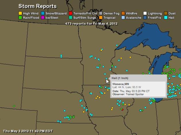
Hail And High Water. All those blue dots are severe
hail reports from Thursday, according to NOAA. 473 separate severe storm
reports for the Upper Midwest yesterday. Map: Ham Weather.
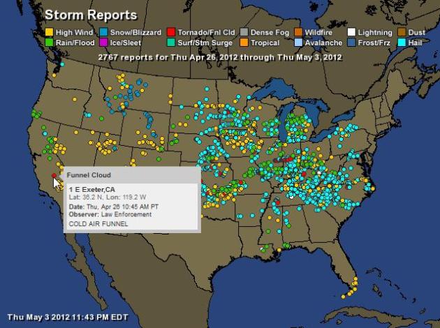
Week's Worth of Storm Reports. According to NOAA:
2,767 severe storm reports from coast to coast since April 26. Only
Texas was spared (ironically), with tornado touchdowns (red dots) from
California to central Kentucky to Brooten, Minnesota. Map: Ham Weather.
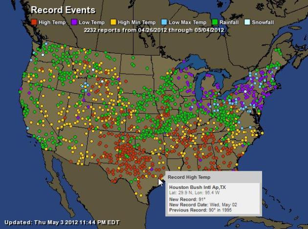
Week's Worth Of Temperature Records. Record chill
across the northeast, record heat in the south, record 24-hour rainfall
reports (green dots) for much of the Ohio Vallley and Plains, westward
to California. Something for the entire family. 2,232 temperature
records in 7 days. Map: NOAA and Ham Weather.
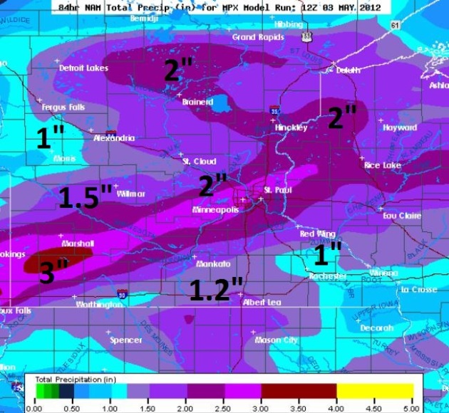 An Old Fashioned Soaking?
 The latest NAM
predicts
more than 1" for the Twin Cities, but I suspect amounts may go higher
than that, as much as 2" for some communities. The best chance of heavy
rain: Saturday night into early Sunday.
 Cooling Trend
. The good news:
no
more frost in sight looking out 2 weeks, at least not for the metro
area. After peaking above 70 today readings drop over the weekend:
low
to mid 60s for highs Sunday, maybe some 50s up north. Readings early
next week will run 5-10 degrees cooler than average for mid-May before recovering to near 70 the latter half of next week.
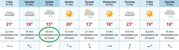
European
Solution: Sunday Soaking. The ECMWF model prints out a few isolated
showers and T-showers today, more numerous showers (late) Saturday, with
Sunday the wettest day in sight. After a cool Tuesday temperatures
recover the latter half of next week.
Meteor Alert. Earth is passing through space junk leftover from Halley's Comet. Details from spaceweather.com below.
Legacy Destinations. Now there's a new (and better?) way to explore Minnesota. Details below.
"
Here in the United States, 82 percent of Americans say that they've experienced a natural disaster or extreme weather event first-hand." - from a Huffington Post article on climate change and extreme weather below.
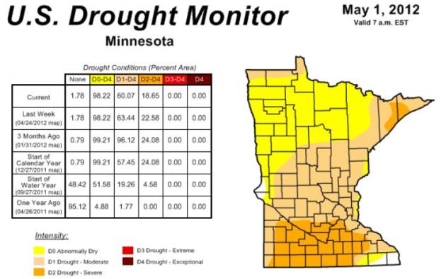
Easing Drought. Here is the latest
Drought Monitor
information for Minnesota, showing a slight improvement, especially
over central and northern counties. The area under "severe drought" has
dropped from 22% last week to 18% this week - further improvement is
likely in the coming days with moderate/heavy rain in the forecast.
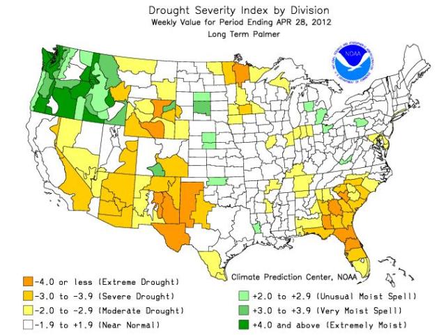
Palmer Index. At a glance you can see what areas of
America are still running a longterm rainfall deficit. Much of Minnesota
needs 2-5" of additional rain to get back up to normal. West Texas,
Wyoming and much of the southeast are also suffering from an extended
dry spell. Meanwhile much of the Pacific Northwest is running a 2-4"
rainfall surplus. Seattle is almost 5" wetter than normal since January
1, over 6" at Portland, Oregon!
Palmer Index courtesy of NOAA.
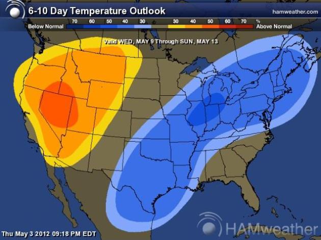
6-10 Day Temperature Outlook. CPC, the Climate
Prediction Center, is predicting a cool bias for much of the eastern two
thirds of America through mid-May, considerably warmer than average for
the western USA. Map courtesy of NOAA and Ham Weather.
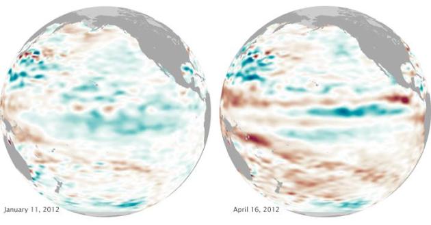
La Nina Comes To A Close. Maybe now our weather will become "normal" again? Don't bet on it. Details from
NASA's Earth Observatory: "
After cooling the eastern tropical Pacific for the second winter in a row—and teaming with other large-scale weather patterns to wreak havoc on North American winter—La
Niña ended in April 2012. Researchers from the Climate Prediction
Center of the U.S. National Weather Service reported on May 3 that the
Pacific has transitioned to “neutral conditions, which are expected to
continue through northern summer 2012.” La Niña and El Niño
are alternating patterns of ocean and atmospheric circulation that
have a distinct impact on weather around the Pacific basin. La Niña
brings cooler waters and stronger trade winds to the tropical Pacific,
boosting precipitation in western Pacific nations like Australia and
Indonesia and drying out southern North America. The pattern can alter
the path of the jet stream and other atmospheric phenomena."
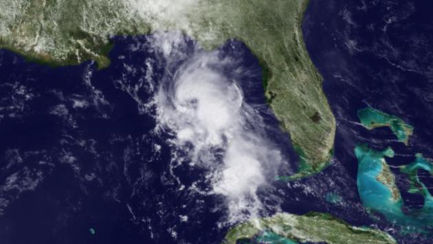
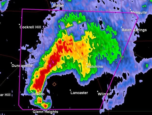
Storms In The Gulf Feed Off Warm Gulf Loop Current.
Gulf of Mexico water temperatures have been running at least 2 F. warmer
than average since February - some meteorologists theorize this may be a
factor in the unusually violent (and early) tornadoes across the USA.
More from
NOAA's Environmental Visualization Laboratory: "
The Loop Current, as seen in NOAA's Daily 5 km resolution sea surface temperature product, is providing fuel for convection today west of Florida in the Gulf of Mexico. The NOAA Atlantic Oceanographic and Meteorological Laboratory's Tropical Cyclone Heat Potential map of the Gulf of Mexico shows."
Report Points To Decline In Ability To Monitor The Earth. Here's a clip from a recent
New York Times article: "
Earth-observing
systems operated by the United States have entered a steep decline,
imperiling the nation’s monitoring of weather, natural disasters and climate change, a report from the National Research Council
warned Wednesday. Long-running and new missions are frequently
delayed, lost or canceled because of budget cuts, launching failures,
disorganization and changes in mission design and scope, the report
said."
Report Warns Of Diminished Tornado Tracking, Hurricane Forecasting, Climate Change Study. Here's an excerpt from
The Oshkosh Northwestern: "
....The number and capability of weather satellites circling the planet "is beginning a rapid decline" and tight budgets
have significantly delayed or eliminated missions to replace them,
according to a National Research Council analysis released Wednesday.The
number of in-orbit and planned Earth observation missions by NASA and
the National Oceanic and Atmospheric Administration is projected to
drop "precipitously" from 23 this year to only six by 2020 based on
information provided by both agencies, the report found. As a result,
the number of satellites and other instruments monitoring Earth's
activity is expected to decline from a peak of about 110 in 2011 to
fewer than 30 by the end of the decade."
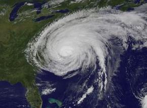
New Data Shows Hurricane Irene From 2011 Now 6th Costliest Hurricane In U.S. History. Details from
wsav.com: "
New
damage estimates released last month by NOAA now place the damage from
2011's Hurricane Irene at $15.8 billion, making the storm the 6th
costliest hurricane and 10th costliest weather-related disaster in U.S.
history. Irene hit North Carolina on August 27, 2011, as a
Category 1 hurricane with 85 mph winds, and made landfalls the next
day in New Jersey and New York City as a tropical storm. Most of
the damage from Irene occurred because of the tremendous fresh water
flooding the storm's rains brought to much of New England."
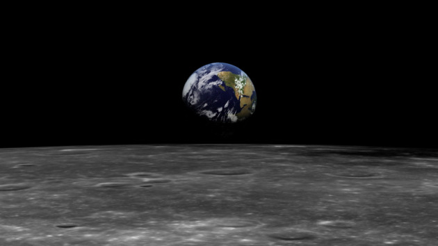
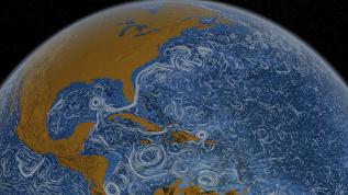
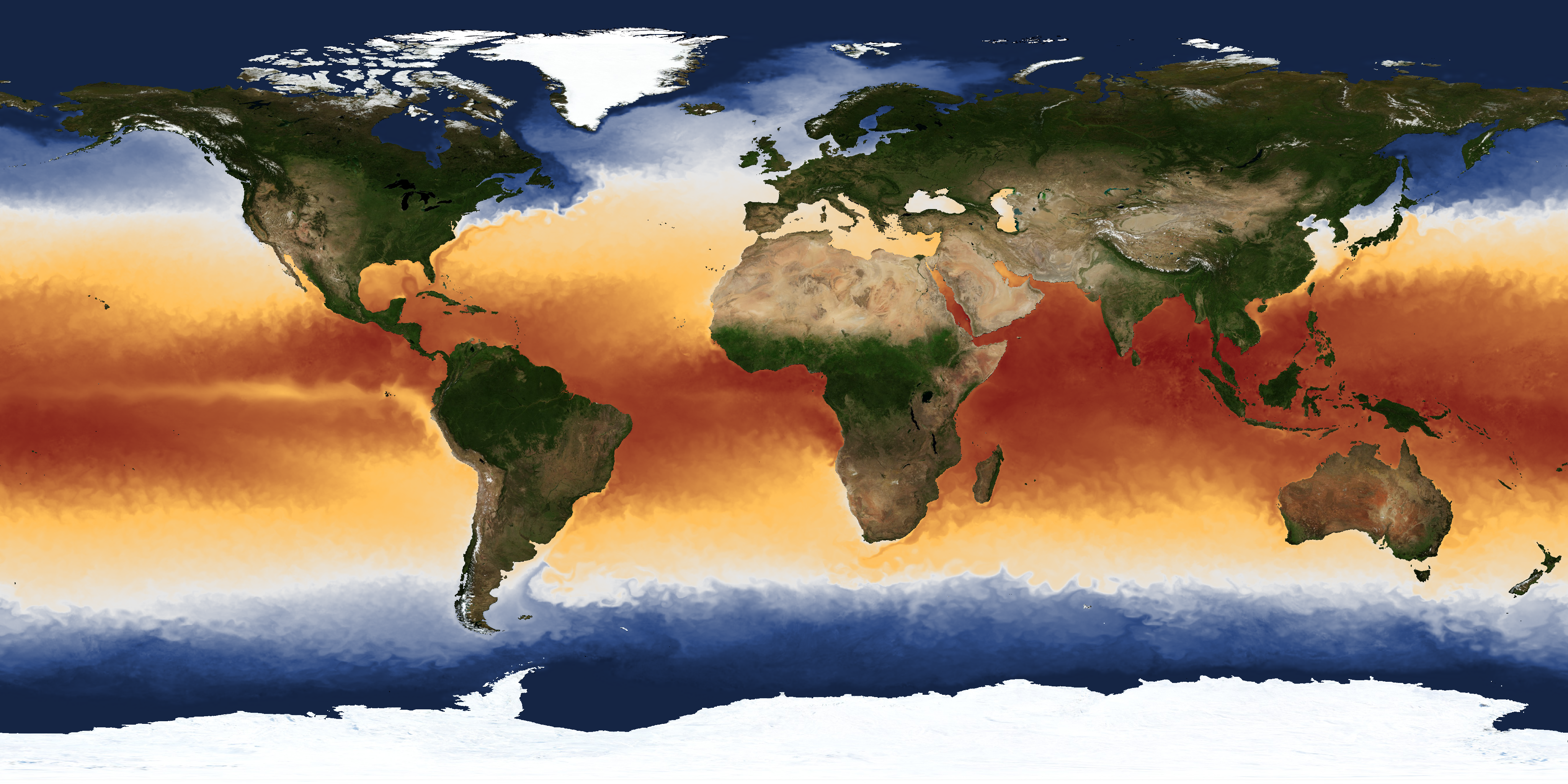
A New View Of The Aqueous Globe. Here's an excerpt of an interesting article at
The New York Times: “
There
is a river in the ocean” are the first words in Matthew Fontaine
Maury’s pioneering work, “The Physical Geography of the Sea,” first
published in 1855. Sailors have always been aware of ocean rivers —
currents, that is — but Maury was the first to produce a scientific
chart of the major currents. It was based on thousands of observations
recorded by seamen and was, in a sense, an expanded version of the Gulf
Stream chart printed in 1769 by Benjamin Franklin after consulting a
Nantucket skipper. "
Image of the "Perpetual Ocean" above courtesy of NASA Goddard's Space Flight Center
Scientific Visualization Studio.
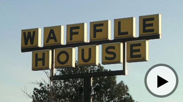
When Disaster Strikes, FEMA Turns To....Waffle House. Here's an excerpt of a fascinating blurb at
Foxnews.com: "
Waffle
House serves hungry customers bacon, eggs and hash browns, but when
disaster strikes, the iconic chain serves up valuable intel to the
government. The Federal Emergency Management Agency has developed an
unofficial, color-coded "Waffle House Index" to help make assessments
before sending response teams to areas hit by such natural disasters as
tornadoes, floods or hurricanes. “When business like that are closed,
that’s a good indication that resources are probably going to be needed
for the survivors there in that area,” explained Will Booher of
Florida’s Division of Emergency Management."
Flood Insurance Debate Resumes As Deadline Nears. Here's an excerpt of a story from Reuters and
The Chicago Tribune: "
(Reuters)
- Federal officials are putting fresh pressure on Congress to take
action on the National Flood Insurance Program, whose authorization
expires at the end of this month, one day before hurricane season
begins. The NFIP has been a political football in Washington for years,
particularly because of the unsustainable debt load it took on in the
wake of Hurricane Katrina
in 2005. There is a broad push to reform the program and put it on a
sound financial footing, but competing visions on that reform (including
whether to forgive the program's debts) have stalled legislation."
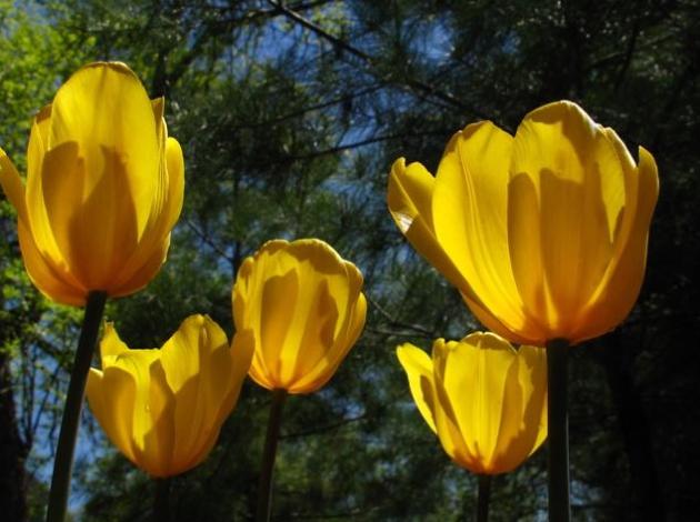
Tulip Tips. Thanks to my friend (and master gardener) Tricia Frostad, for passing these tips along: "After
all this rain you may lose a lot of those pretty tulip petals. The
ground around them is now littered with what used to make up that
beautiful flower. To give the bulbs the best chance of returning next
year, cut the stem back so that it does not produce seeds but do not
remove the leaves. I know they are not th emost attractive to look at,
but those leaves need the sun to create energy through photosynthesis.
If you remove the foliage too early, there won't be enough energy stored
to feed the bulbs and you'll end up with smaller or fewer blooms. It's
best to wait until the leaves are brown and dead-looking, usually about 6
weeks or late June (probably earlier this year). Following this rule
will give you the best chance of another great show next spring." Thanks Tricia.
* more tips for tulips from the Quad City Times here.
Meteors From Halley's Comet. Here's an excerpt from
spaceweather.com: "
Earth
is entering a stream of debris from
Halley's Comet, source of the annual eta Aquarid meteor shower.
The shower peaks this weekend; the best
time to look is during the hours before
sunrise on Sunday, May 6th. Because the shower's
radiant is located below the celestial equator,
southern hemisphere observers are favored, but even
northerners should be able to see a few flecks
of Halley-dust disintegrating in the
atmosphere. Super-bright moonlight will cap the meteor rate at about 30 per hour."
"Ask Paul". Weather-related Q&A:
Paul,
"
My daughter and her family live in a hollow, of sorts, on the
Mississippi south of Little Falls. They cannot get a signal for their
weather radio. While they will attempt to add an external antenna,
I scanned through articles on weather apps for iPhones (which they
have). It is not clear to me whether they will wake you up at night with
an alarm. I recall you writing about this very recently as I read your
blog every day. What is their best bet in the event the external antenna
does not work?"
Mary
Mary - NOAA Weather Radio is an amazing tool, but there are valleys
and hollows where reception is poor. There are a couple of apps that may
help, including
iMapWeather Radio ($9.99) and My-Cast Weather Radar.
My-Cast Weather Radar
costs $3.99 (one-time charge) - both apps allow you to set up favorite
locations, and then receive visual and audible alerts if a warning is
issued for your location. It's not quite as good as NOAA Weather Radio
(which lets out an audible shriek if a warning is issued at 3 am) but
it's better than nothing. I don't know of any (good) free alerting apps.
The reality:
it costs $$ for companies to
keep servers running to push out these alerts, and advertising just
doesn't get the job done, so for a quality solution you're going to
spend a few bucks. Better solutions are coming!
* Full disclosure: I don't have any equity/business interest in
either company, and no, I don't get a commission for recommending these
apps. I just think they're two of the best alerting apps out there on
the IOS market today.
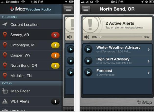 Screen Shot From iMapWeather Radio
, showing how you can save different locations and set different alerts for each town.
________________________________________________________________________
Hi-
"
Storm just ripped through our area of Eagan. We live in a wooded
area and behind our house we have at least 10 trees knocked down,
including one large oak tree. Is that common to have just an isolated
area have trees knocked down in a storm like this? Probably in a 150x200
foot area..."
Thanks,
Tim
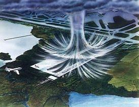
Tim- it sounds like you may have experienced a rare
microburst,
a severe thunderstorm downdraft that reached the ground, fanning out
into damaging straight-line winds that may have exceeded 60-70 mph. Hard
to say; the line that rumbled across the metro Thursday morning became
more severe as it pushed into the eastern suburbs. My hunch:
microburst. Link and image above courtesy of Wikipedia.
Legacy Destinations. We live in a remarkably diverse
state with much to do, much to see. My wife and I try to check out a
new town, a new Minnesota destination, every month. There may be a
better way to explore Minnesota. Check out the Legacy Destination
program at
Explore Minnesota: "
The passage of the "Legacy Amendment"
in 2008 created new funds to develop and support Outdoor Heritage,
Clean Water, Parks and Trails, and Arts and Cultural Heritage throughout
Minnesota. Legacy Destinations will host a weekend of arts, history
and outdoor events and activities during each month May through
September. The events celebrate these local resources and organizations
to their communities and offer Minnesota residents and visitors an
eclectic assortment of fun activities throughout the year. This is a
statewide collaborative project between the Minnesota Citizens for the
Arts, Conservation Minnesota, Explore Minnesota Tourism and local
community partners."
Site Of The Day: "The Cool Hunter". If you haven't investigated this site, it's worth a look. What is The Cool Hunter? "
I recently found a cool website called The Cool Hunter.
There are so many amazing photos on this site. Everything from travel,
architecture, art & design to urban living, gadgets and fashion. I
thought I'd share some with you now that I found so enjoy!"
"SAVE" Fashion Show. I've been involved with
SAVE (suicide
awareness, voices of education) for nearly 10 years, ever since Randi
Kaye's father died at his own hands. I saw the impact the suicide had on
her. My youngest son lost one of his best friends - it seems like every
family has been touched by depression and suicide. Everyone seems to
know someone who didn't get the help they needed to avoid an ultimately
preventable tragedy. There's something you can do about it - SAVE, based
in Bloomington (with a national outreach) has a Fashion Show coming up
in Excelsior on June 1. Check out the other SAVE events and fundraisers
here - including an annual golf tournament in August.
Here are the details on the Fashion Show - hope to see you there.. I'm a "model" - another sign of the pending Apocalypse.
7th Annual SAVE Fashion Show
Friday, June 1, 2012
6:30pm to 10pm
BayView Center
687 Excelsior Boulevard, Excelsior, MN
General Admission Tickets $40 ($50 at the door)
VIP Seating $100 (will not be available at the door)
VIP Tables of 8 $1,500 (limited tables available)
The 7th Annual SAVE Fashion Show will be held at the beautiful
BayView Event Center
on Lake Minnetonka in Excelsior and includes fabulous fashions, great
food by Wally's Roast Beef and a fantastic silent and live auction.
This years 60's & 70's fashions will be modeled by ICON's
Management models and Mark Steine of E SALON and his team of models
along with local celebrities. All models will be wearing specially
designed clothing by Christopher Straub, Samantha Rei Crossland and
others. This will be an amazing show that you don't want to miss!!
Meet "Signal", The Instagram Of Citizen Journalism.
Social media is changing...everything, including journalism. Good
idea? Here's a snippet of an article explaining this new app from
mashable.com: "
What
do you get when you combine a photo-sharing mobile platform like
Instagram with more geo-location awareness and a Reddit-style voting
system for stories breaking all over the world? Answer: Signal, the app citizen journalism may well have been been waiting for. The Signal app is currently in private beta launch, and will hit app stores for the iPhone in the next few months. You can sign up to test the app here.
Signal is the brainchild of Lebanese entrepreneur Mark Malkoun, who
says it will address the fundamental limitations of sharing stories on social media."
Who Will Survive The Social Media Bubble? Is Facebook worth $100 billion, give or take? Will we still all be using FB in 5 years? Remember AOL? Who knows - but
Read Write Web has an interesting series about the inevitable social media shake-out: "
A New York Times article
in Sunday's editions highlighted smaller, niche social networks that
gave people more control over their privacy when compared to the giants
such as Facebook, Google+ and Twitter. The article reviewed Path (for sharing with a small group of people), FamilyLeaf (for sharing with family members only) and Pair
(for sharing with one other person). These networks, and hundreds of
others like them, fill an obvious void that the big three social
networks are missing. The question is whether that void is big enough
to justify revenues that will allow all of these lesser social networks
to survive."
How To Muddy Your Tracks On The Internet. Paranoid about security? You should be. Here's an excerpt of an article at
The New York Times: "
Legal and technology researchers estimate
that it would take about a month for Internet users to read the
privacy policies of all the Web sites they visit in a year. So in the
interest of time, here is the deal: You know that dream where you
suddenly realize you’re stark naked? You’re living it whenever you open
your browser. There are no secrets online. That emotional
e-mail you sent to your ex, the illness you searched for in a fit of
hypochondria, those hours spent watching kitten videos (you can take
that as a euphemism if the kitten fits) — can all be gathered to create
a defining profile of you."
"Tree Piece" Helmets: Protective Loggin' For Your Noggin. Headline of the week? If you're looking for a unique helmet look no further than
gizmag.com: "
If
you want your product to stand out while also looking classy, warm and
organic, there’s one sure-fire way of doing in – make it out of wood.
In recent years, we’ve seen things like wooden headphones, MP3 players, and bicycles.
Now, sports helmets can be added to that list. Oregon-based woodworker
Dan Coyle started making his own wooden-shelled helmets in the late
90s, for his own use while whitewater kayaking. Just in the past few
years, however, he got the idea of making them for other people. The
result is his current line of Tree Piece Helmets."
"
I have found the paradox that if I love until it hurts, then there is no more hurt, but only more love." - Mother Teresa.
Drought-Busting Rains?
Wouldn't it be great if we could time rainy
soakings for weekdays, late at night, well away from your commute times?
We're working on that technology. Sadly, it'll be a company composed
entirely of lawyers. Once you start tinkering with the weather the
liability implications are staggering. What if you "seed" clouds and a
flood breaks out 100 miles downwind? Not good.
Storms, given a choice, PREFER to come on weekends; Murphy's little-known Second Law. 3 soggy Saturdays in a row? Uh huh.
The volatile warm front that sparked several
waves of severe, hail-producing storms sags just south of the MSP metro;
today 10 degrees cooler with a few T-showers. A storm rippling along a
stagnant east-west frontal boundary throws a shield of heavier, steadier
rain into Minnesota late Saturday into Sunday. Some 1-3" rainfall
amounts are possible - a few severe storms possible over southwestern
Minnesota.
According to NOAA's Palmer Index (details on the
blog) much of our fair state is still running a 2-5" rainfall deficit
since last autumn. The timing stinks, but our weekend soaking is a
meteorological Godsend for farmers.
No more frost in sight - I think you're safe to plant annuals.
Climate Stories...
Panetta: Environment Emerges As National Security Concern. Here's an excerpt from a recent story at the
U.S. Department of Defense: "
Climate
and environmental change are emerging as national security threats that
weigh heavily in the Pentagon's new strategy, Defense Secretary Leo E.
Panetta told an environmental group last night. "The area of climate
change has a dramatic impact on national security," Panetta said here at
a reception hosted by the Environmental Defense Fund to honor the
Defense Department advancing clean energy initiatives. "Rising sea
levels, severe droughts, the melting of the polar ice caps, the more
frequent and devastating natural disasters all raise demand for
humanitarian assistance and disaster relief," Panetta said."
The "Reasonable Middle" On Climate Change. Is there
common ground somewhere between the "warmist/alarmists" and the
"deniers"? Dr. Jon Foley from the University of Minnesota's Institute on
the Environment has a pragmatic take on climate change; here is a
portion of an interview at
grist.com: “.....
Some
people underplay the problem; some people overplay the problem; I play
it down the center, just the straight facts. I am not on a side. I am
in the reasonable middle.” I’d note two things about this message.
First, it is true. It is true that climate impacts will be worse than
the skeptics say and not as bad as some climate hawks say. It is also
true that Foley is honest, non-tribal, and scrupulous about scientific
facts when he communicates. Second, this kind of stance, being in the
reasonable center, is extremely attractive to a certain (I’ll never
forgive myself for using this word) psychographic, folks I somewhat
clumsily call “characterological centrists.”
People of a certain temperament will naturally drift to a Goldilocks —
not too hot, not too cool — position on matters of political import.
They want to be seen as credible, independent brokers of truth, not as
activists saying whatever it takes to advance one side or the other."
"Connecting The Dots" Between Climate Change And Extreme Weather. Here's an excerpt from a story at
The Huffington Post: "
Over the last year, millions of people around the world have felt first-hand the impacts of the growing climate crisis. From devastating flooding in Thailand to historic drought in Texas, global warming has moved from an abstraction to a dangerous new reality. Here in the United States, 82 percent of Americans say that they've experienced a natural disaster or extreme weather event first-hand. Yet, despite a few notable exceptions,
the mainstream media has failed to connect the dots between this
string of extreme weather events and global warming. Instead, coverage
of climate change has dropped precipitously. A recent report
by Media Matters for America found out that nightly news coverage on
the major networks decreased 72 percent between 2009 and 2011. The
Sunday shows, traditionally seen as forums for discussing the "important
issues" of the day, have all spent more time covering Donald Trump
than they have climate change."
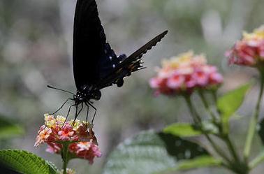
Plants Flowering Much Faster As Global Temperatures Rise. Details from
The Christian Science Monitor; here's an excerpt: "
Plants are flowering faster than scientists predicted in response to climate change, research in the United States
showed on Wednesday, which could have devastating knock-on effects for
food chains and ecosystems. Global warming is having a significant
impact on hundreds of plant and animal species around the world,
changing some breeding, migration and feeding patterns, scientists say.
Increased carbon dioxide concentration in the atmosphere from burning
fossil fuels can affect how plants produce oxygen, while higher
temperatures and variable rainfall patterns can change their behaviour."
Photo credit above: "
A butterfly lands on a flowering
Confetti Lantan plant in San Antonio, Texas. Scientists have commonly
under-predicted the climate change's effects on plants, says new
research." AP Photo/Eric Gay.
Much Ado About Nothing. Wind Farms = Global Warming? Here's a snippet of a story from
smartgridnews.com: "..
.So
is it a big deal? Zhou doesn't seem to think so. In a Q&A related
to the study Zhou said "Overall, the warming effect reported in this
study is local and is small compared to the strong background
year-to-year land surface temperature changes. Very likely, the wind
turbines do not create a net warming of the air and instead only
redistribute the air's heat near the surface (the turbine itself does
not generate any heat), which is fundamentally different from the
large-scale warming effect caused by increasing atmospheric
concentrations of greenhouse gases due to the burning of fossil fuels."
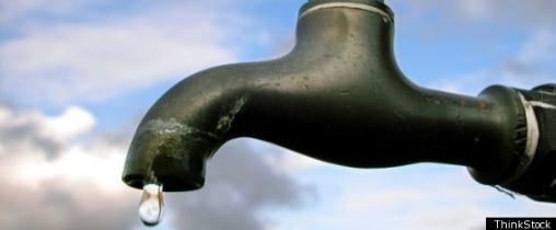
OECD Calls For Policy Reform And Technology To Prevent Impending Water Crisis. An interesting story from
gizmag.com; here's an excerpt: "
Worldwide
population growth and the related rapid increase in urbanization is
already posing problems in many areas for the management of that most
precious of resources, water. With these problems only set to
intensify, the Organization for Economic Co-Operation and Development
(OECD) has released a report outlining the challenges humanity faces to
maintain water resources in the face of demographic growth and climate
change. Called Meeting the Water Reform Challenge, the report says
that urgent reform of water policies is crucial in order to preserve
human and environmental health as well as economic growth."
When Global Warming Ate My Life. Here's an interesting story from
Huffington Post: "
Hell
is not a place; it's a time. It starts with the experience of
irreversible loss and ends as you learn to live with loss. My hell time
began on a summer night in 2009 while wrapping brownies at the kitchen
table in our Maine farmhouse. Fifteen years earlier my husband and I
gave up fame and fortune to raise our son and daughter on a Maine farm.
We wanted them to grow up with the respectful down-to-earth values of
our small Maine town. We hoped they would shape deeply lived authentic
lives surrounded by natural beauty and bound to the rhythms of the
seasons."

