
"...Steve Scolnik at Capital Climate analyzed the data from NOAA’s National Climatic Data Center and found U.S. heat records in June outnumbered cold records by 2706 to 251 — nearly 11 to 1." - article on June heat below.
Friday Severe Risk. A few isolated severe storms may fire later today from the Mid Atlantic states westward to Memphis, a second risk area from northeastern Colorado into the Dakotas.
Saturday Severe Threat. By Saturday the risk of hail/damaging winds shifts from the central Plains iinto southern and central Minnesota and western Iowa.
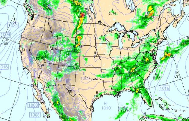
Friday Rainfall. The latest WRF/NAM model shows potentially severe storms rumbling across the Dakotas later today, a broad region of heavy showers and storms from Florida up the east coast into upstate New York, puddles predicted westward to Memphis and Little Rock. Most of the west stays dry - more 100-degree sunshine across Texas.
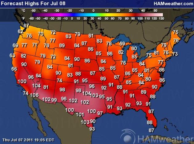
Another Free Sauna For The South. It's deja vu all over again. More 100s from California to Texas, comfortable 70s for New England. cool 60s from the Bay Area north to Portland and Seattle.
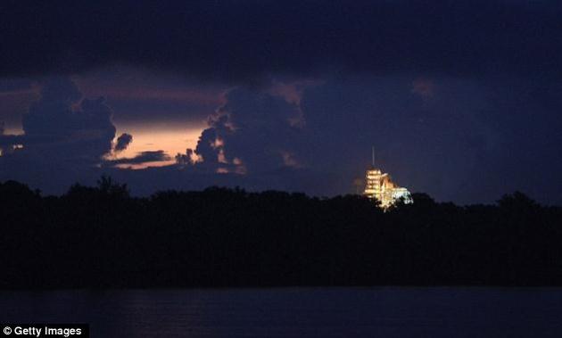
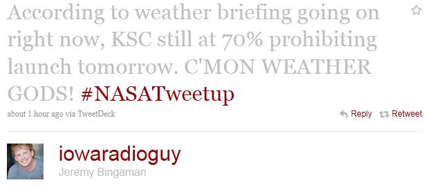
- By mid-afternoon, Kennedy Space Center was hit by a series of rain squalls – and at least one lightning strike roughly a third of a mile from the shuttle's launch pad. NASA officials immediately dispatched technicians to check for damage, though there were no immediate indications of any.
- Nonetheless, preparations for the launch remained underway.
- The Rotating Service Structure protecting Shuttle Atlantis was pulled away Thursday around 30 minutes later than planned due to the weather.
- Friday's launch of the space shuttle Atlantis remains iffy, with NASA saying Thursday morning there is a 70-percent chance that the launch may be delayed. And chances for bad weather scrubbing a Saturday lift-off are 60 percent.
- A tropical wave has moved into the Space Coast area from the south, threatening rain, lightning and overcast conditions Thursday and continuing into Friday, when Atlantis is scheduled to lift off at 11:26 a.m. ET.
- If late-morning weather forces NASA to scrub the launch, Saturday may be nearly as problematic for an 11:02 a.m. launch. If NASA reschedules for Sunday, launch time would be 10:38 a.m.
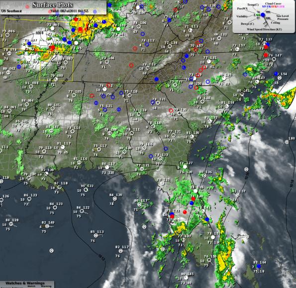
Tropical Wave: Florida Soaking. Here's more information on the tropical system generating heavy thunderstorms and flooding rains over the southeast. Parts of Florida have gone from drought to flood in the the span of 72 hours.
- An elongated low pressure system located about 300 miles southwest of Tampa, Florida has become a little better defined during the past few hours.
- In addition, surface pressures have decreased over the eastern Gulf of Mexico during the last 24 hours.
- Environmental conditions are expected to become marginally conducive for some additional development of this disturbance.
- There is a 40% chance of this system becoming a tropical or subtropical cyclone during the next 48 hours as it moves slowly northward or north-northeastward.
- Regardless of development, this weather system will produce periods of locally heavy rainfall across most of the Florida Peninsula and the eastern Florida Panhandle during the next couple of days.
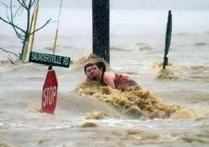
Photo credit above: (Credit: With permission from Rick Murray.)
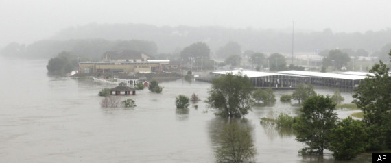
- North Central U.S. including Souris River (North Dakota) and Red River of the North (border of North Dakota and Minnesota), Minnesota River (Minnesota), Upper Mississippi River (Minnesota and Iowa), and Des Moines River (Iowa)
- Lower Missouri River from Gavin’s Point (Nebraska and South Dakota border) downstream along the border of Nebraska and Iowa, continuing through the borders of Kansas and Missouri then through Missouri to the Mississippi River
- Tributaries to the Lower Missouri including the James and Big Sioux Rivers in North Dakota
- Lower Ohio River Valley including the White, Wabash and lower Ohio River
- East of Rockies: North Platte River in Colorado, Wyoming and Nebraska and Yellowstone River in Wyoming and Montana
- West of Rockies: Utah and Colorado
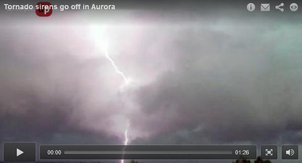
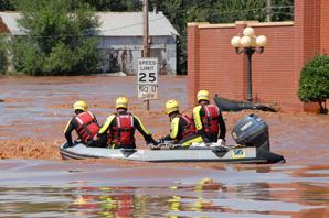
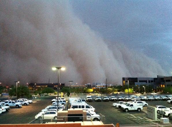
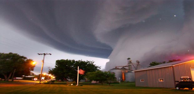
Heavy Rains Pound Denver Area, Street Flooding Traps Cars. The Denver Post has the latest on severe storms that roared through the Denver area late Thursday: "A severe thunderstorm is dropping heavy rain, flooding streets, swamping cars, sweeping away manhole covers and causing power outages as it moves through the metro area. Denver Fire Department crews has made scores of water rescues as more than 10 cars at a time found themselves trapped in rising, fast water, said Lt. Phil Champagne. "It's widespread through the city, but the northeast quadrant has been hard hit," he said. "But it's been all over the board, and it's been fast and furious all afternoon long." Xcel Energy reported that, as of 8 p.m., 18,000 customers were still without power. Xcel spokesman Mark Stutz said Xcel called in extra crews to help restore the power. The National Weather Service reported numerous gauges indicated 2 inches of rain fell on parts of Denver in less than an hour between 4:15 p.m. and 5:15 p.m. Denver and Aurora are under a flash flood warning until 10:15 p.m. for parts of Denver, Arapahoe and Adams counties. A severe thunderstorm warning expired at 6 p.m. The National Weather Service also issued a flash flood warning for central Boulder County until 9:15 p.m. "This is a life-threatening situation," the National Weather Service in Boulder stated. "Heavy rainfall will cause extensive and severe flash flooding of creeks, streams and ditches the Fourmile burn area."
Thursday Records:
- Oklahoma City, OK: 108 Old record: 106 in 1996
- Fort Smith, AR: 107 Old record: 106 in 1964
- Tulsa, OK: 104 Old record: 103 in 1917
- Record coldest highs
- Naples, FL: 81 Old record: 85 in 1968
- Miami, FL: 81 Old record: 83 in 1933
- West Palm Beach, FL: 82 (tie) Old record: 82 in 1988

Number of Record Highs In June:
Houston - 7
Birmingham - 6
Amarillo - 6
Mobile - 5
Savannah - 4
Memphis - 4
St. Louis - 4
Washington D.C. - 3

Las Conchas Fire Update. Photo above courtesy of Wikipedia. Here's the latest on New Mexico's largest wildfire on record. An increase in relative humidity, lighter winds, and showers and T-storms in the area have helped firefighters get an edge of the blaze. A few details:
- According to the latest infrared mapping, the Las Conchas fire had burned 136,955 acres and was 40 percent contained.
- It’s still smoky in northern New Mexico, but life is returning to normal as thousands of employees are back at work after a wildfire had threatened the nation’s premier nuclear weapons laboratory.
- The danger to Los Alamos National Laboratory and the town that surrounds it has waned.
- Scientists and technicians will spend the next few days assessing the status of key research projects.
- So far 63 residences have been destroyed since the fire began with a downed tree falling into a power line on June 26, and another 410 residence remain threatened.
- A total of 32 outbuildings have been destroyed, and 45 are threatened, and five injuries have been reported to date.
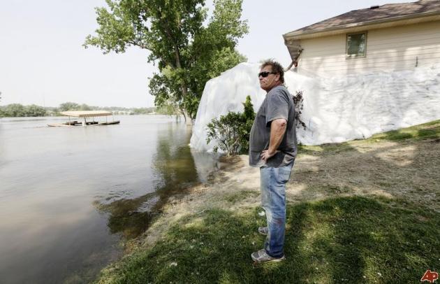
Disaster? Don't Panic - Everything Can Be Fixed. The Telegraph-Journal has some good advice for people facing a disaster, weather-related or otherwise: "What you need to do is take some time and assess what really needs to be done.
1. Don't panic. Yes, it's a disaster, but try not to overreact. Everything can be fixed. Call your insurance company.
2. Safety first. Make sure your home and family are safe. Call in the right pros. For example, in the case of flood, have the electrical system checked before it's used. Don't enter a building that's not structurally safe.
3. Clean up. Wear appropriate protective clothing, masks and gloves, and get rid of destroyed furnishings, such as carpet and drapes. Tear out drywall and soaked insulation.
4. Assess. Now that you've cleaned up, you can see what the extent of the damage is, and what you can and should do first.
5. Take your time. Rushing always costs more and it leads to mistakes.
Did you see on the list where I said call the contractor? No, because it's not there. One of the worst things you can do is to hire too quickly. That's where you hire the wrong guy.
I've always said the best contractors are the busiest. They aren't able to immediately come and do your repair - disaster or not. You will have to wait."
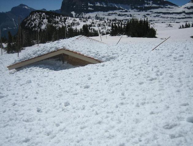
Logan Pass Restroom Facility - Glacier National Park. O.K. I won't be using that restroom anytime soon. The amount of snow still on the ground at Glacier National Park is remarkable - check out GNP's flickr page.
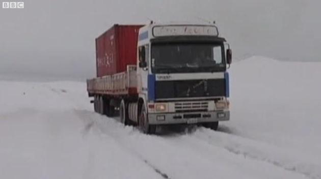
Hyper-Arid Atacama Desert Hit By Snow. Freakish weather continues to daze and amaze (meteorologists). The Atacama Desert is thought to be the driest spot on the face of the Earth. The BBC has a video update on a bizarre snowstorm in the desert: "A large dump of snow has fallen on the Atacama desert in South America, one of the driest places on earth."
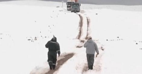
Paralyzing Snowstorm In The Driest Spot On Earth? Steven Goddard's Real Science has more details on the mind-boggling snowstorm in the Atacama Desert: "One of the driest spots on earth has experienced its heaviest snowfall in almost two decades, according to the Chilean Directorate of Meteorology (DMC). A cold front brought up to 80 centimetres (31.5 inches) of snow to the Atacama desert region of South America forcing emergency services to close local roads and rescue dozens of motorists from their vehicles. The temperature in the Chilean capital, Santiago, dropped below minus 8c on Wednesday. Neighbouring Argentina and Uruguay are also experiencing subzero temperatures."
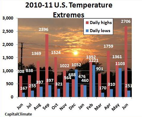
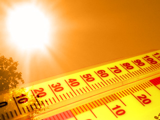
It's Obscenely Hot: June 2011 Heat Records Crush Cold Records By Nearly 11 To 1. Here are the NOAA details from Joe Romm at Climate Progress: "Steve Scolnik at Capital Climate analyzed the data from NOAA’s National Climatic Data Center and found U.S. heat records in June outnumbered cold records by 2706 to 251 — nearly 11 to 1:. I like the statistical aggregation across the country, since it gets us beyond the oft-repeated point that you can’t pin any one record temperature on global warming. If you want to know how to judge whether the near 11-to-1 ratio is a big deal, see “Record high temperatures far outpace record lows across U.S.” As for global temperatures, the anti-science crowd had been crowing that this year’s big La Niña — which they called a “Super La Niña” — would drive temperatures way, way down. But even the satellite datasets, which are more sensitive to the El Niño Southern oscillation, show that how modest and short-lived the temperature dip was."
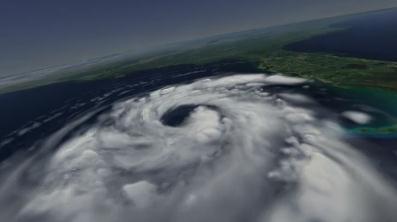
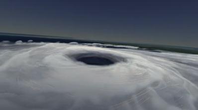
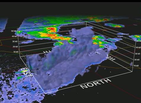
Katrina In 3-D. The NCSA Advanced Visualization Laboratory has an amazing animation of Hurricane Katrina, a 3-D thumbprint showing the inner anatomy of the growing superstorm, which went on to devastate much of coastal Louisiana and Mississippi in 2005: "A new visualization showing the dramatic evolution of hurricane Katrina, the storm that wreaked havoc along the east coast of the US in August 2005; created by Advanced Visualization Laboratory, is featured on the blog, New Scientist TV and on the NCSA homepage. The animation is part of a full-length planetarium film called Dynamic Earth which explores the inner workings of the Earth's climate engine."
"Science is the belief in the ignorance of the experts" – Richard Feynman
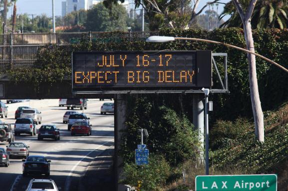
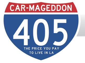
"Car-Mageddon". L.A. Prepares For The Worst And Hopes For The Best In Freeway Shutdown. You may want to avoid Los Angeles the weekend of July 16-17. The New York Times has the latest: "LOS ANGELES — You would think that Los Angeles, of all places, would know how to handle a catastrophe. But in just over a week, 11 miles of Interstate 405 — the north-south spine of the West Side of Los Angeles, which carries 500,000 cars every weekend over the Sepulveda Pass into the San Fernando Valley — is going to shut down for 53 hours, from late Friday night to early Monday morning. No cars, trucks or motorcycles will be allowed, to make way for the latest phase in a $1 billion widening project for a highway that serves as an unhappy second home for commuters during rush hours. And they are calling it Carmageddon. City officials are warning of a traffic nightmare, urging people to stay home or get out of town with pronouncements that have taken on an increasingly alarming tone. “EXPECT BIG DELAY” reads the warning on electronic billboards on highways and streets from Bakersfield to San Diego. The Metropolitan Transportation Authority has an official “Countdown to the Closure” clock on its Web site, ticking down to the weekend of July 16 and 17. The Los Angeles Police Department, leaving no electronic stone unturned, asked Lady Gaga to post a warning on her Twitter feed, which has 11.4 million followers and is usually more concerned with promoting “Born This Way” than a highway."
* The "Car-Mageddon" web site, with up-to-the-minute details of the 405 closure, is here.

Turn Your iPhone Into A DSLR Camera. MWD, Mixed Web Data, has the story, an interesting development for anyone who wants to push the limits of their iPhone's built-in camera: "Photojojo just came up with another cool iPhone gadget called iPhone SLR Mount. With iPhone SLR mount you can attach your SLR lense that you have been using it for DSLR camera. Photojojo SLR mount for iPhone supports two types of SLR Lenses: Canon and Nikon as of right now, it is still unknown if they will release any other mounts that are compatible with Sony, Pentax and some other slr lenses."
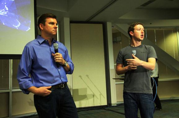
Facebook Offers Video Chat In Arrangement With Skype. Pretty shrewd on the part of Mr. Zuckerberg, integrating video chat into Facebook. No wonder they have 750 million users. The New York Times has the details: "PALO ALTO, Calif. — Hoping to give its users a more intimate way to stay in touch, Facebook on Wednesday introduced video chatting inside its online social network through a deal with Skype, the Internet calling service. The new feature allows users a way to connect with friends other than just posting messages, said Mark Zuckerberg, Facebook’s founder and chief executive, said at a news conference here at the company’s headquarters. “It’s so easy, so minimal to use,” he said. Last week, Google introduced Google+, its latest and most serious challenge yet in social networking, which includes video chatting for up to 10 people in an area of the site called Hangouts. So far, Google has limited the number of people who can sign up for the networking service. To a certain extent, Facebook is playing catch-up — an unfamiliar position for a company that has grown to 750 million users worldwide, a figure Mr. Zuckerberg disclosed at the news conference. He has spent the last few years lifting Facebook past its rivals — it had 500 million users a year ago — but now faces questions about why he is following their lead."

Facebook Gets Skype-Powered Video Calling. Gizmag.com has more details: "As expected, Facebook has announced Skype-powered video calling for its users, who now number more than 750 million according to the company. The new feature was unveiled by Facebook CEO Mark Zuckerberg and Skype CEO Tony Bates at a news conference at Facebook HQ on Wednesday where Facebook engineer Philip Su provided a walkthrough of the application. The social networking giant also launched a new chat sidebar and what Su says is one of the site's most requested features in multi-person chat. Facebook video calling won't require users to set up a Skype account but will require a one-time setup. This will be triggered the first time someone attempts to call you or you attempt to call someone by clicking the 'Call' button that now appears between the 'Message' and 'Poke' buttons on a friend's profile or at the top right of a chat window. Users can also leave a video message if the call recipient doesn't respond."
Climate Stories...

Fat Planet: Melting Ice Caused By Global Warming Is Adding Girth To Earth's Girth. The U.K. Daily Mail has the (eye-opening) story:
"The Earth is putting on 'weight' around its 'midriff' - and global warming is to blame. Melting ice in Antarctica and Greenland is adding volume to the oceans and this extra water is being pulled towards the Equator, adding to the girth at the widest part of our planet, according to scientists. Earth had been 'slimming down' following the Ice Age, which finished about 20,000 years ago. During this geological period of long-term reduction in the temperature of the Earth's surface and atmosphere, the weight of ice sheets was so great that they deformed the Earth's crust and mantle, causing it to bulge at the middle. The Earth isn't completely spherical - land at the North Pole is a number of kilometres nearer to the core of the planet than land at the Equator."
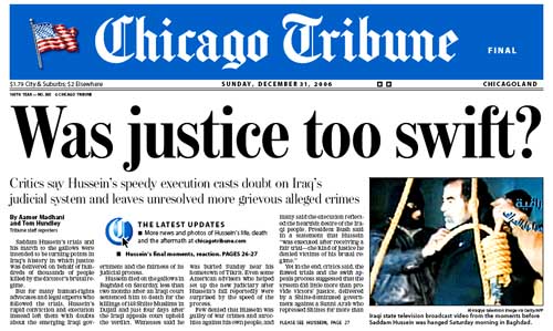
Chicago Tribune: "We're 75% Honest About Climate Change. The story from Think Progress: “We don’t have set policy on climate change,” Cristi Kempf, the national foreign editor at the Chicago Tribune, told Midwest Energy News’ Tom Vandyck:
You have to remember that most European newspapers are papers with point of view, maybe liberal or right wing. Most U.S. papers still do try to retain that objectivity. We will print stories that bring both sides of the view. We will print stories about climate change presenting it as fact, and we will print stories about people who say climate change doesn’t exist. It’s very obvious that a lot of people, including members of the U.S. Congress, believe it’s not true.
When people say they are disbelievers of climate change, you have to point out that most of this has been debunked. I would say most of our stories — 75 percent — are overwhelmingly showing that climate change exists. Ice is melting, animals are dying — that kind of thing. And then every once in a while, you get something else.One might hope that a major newspaper might aim for a higher rate of accuracy on an issue of civilizational importance than three out of four."
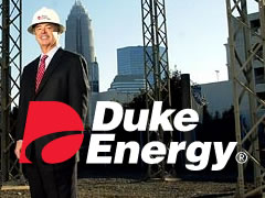
To Stay Competitive, Businesses Urged To Make Climate Resiliency A Priority. The story from Reuters. Three cheers to Duke Energy for taking a brave, proactive role in preparing their business for the 21st century: "As Duke Energy attempts to scale back its 100 million-ton greenhouse gas footprint to reduce future emissions, the utility giant is also studying how it can cope with the damage already being caused by climate change. The Charlotte, N.C.-based power company is in the third and final year of a $1 million effort with the nonprofit Nature Conservancy to slow saltwater intrusion in the Albemarle Peninsula, near the Outer Banks. By creating oyster reefs and planting 20,000 different kinds of trees in the estuary, the research team aims to ward off rising sea levels and restore the ecosystem's peat-rich soils before the peninsula is submerged in a century. Heather Quinley, Duke's director of energy and environmental policy, said the project marked the start of the utility's efforts to develop climate preparation plans for the areas it serves. It has also made the utility one of a growing, but still small, number of companies trying to address adaptation, as global warming shifts agricultural patterns and alters coastlines."
Leaving the "Carnival" Of Climate Change Denial. Rev. Jim Ball has some thoughts on the religious, moral implications of climate change at Huffington Post. Here's an excerpt: "It is well past time for those of us still at the carnival of climate denial to exit the gates and allow the love of God to help us see and face the truth about climate change or global warming and the need to act. Once we do, we will discover that overcoming global warming presents us with tremendous opportunities to love God back and create a better world. Let me clarify things right up front: climate inaction is no longer an option for those who have the love of God in their hearts.
What are some of the common barriers to action? Let's face them together:
Simple Ignorance
Do you not know what a serious threat global warming is, especially to the poor and vulnerable? Do you not understand that we all have a role to play, that for Christians overcoming global warming is now a part of following Jesus Christ today? Then it's past time for you to understand this. My book, Global Warming and the Risen LORD, can provide some guidance (as well as a great deal of encouragement).
"I Still Don't Think the Science is Settled"
Some of you might want to say to me, "Jim, you may think the science is settled, but I still don't think it is. I'm sorry, but reasonable people can still disagree." For Christians and others of good will, this dodge is simply unacceptable today. If you are still not convinced, read the latest reports from our National Academy of Sciences (NAS) for yourself. (Check out my earlier blog for a brief introduction.) Ask God to help you see the truth, to have "eyes to see."
Climate Change: Get Practical About Issue. The Florida Times-Union has a thoughtful Op-Ed at jacksonville.com: "The Times-Union supports solutions that work on several levels, such as improving the nation's energy independence and lowering long-term energy costs. This newspaper has endorsed proposals that would be revenue neutral - taxing carbon, for instance, but reducing payroll taxes by the same amount. That would provide incentives for what's needed - jobs - and disincentives for what we don't need - carbon.
Practical solutions
Better gas mileage: Better fuel-efficiency standards for cars. In recent years, automakers often have used efficiency improvements to make cars heavier rather than more fuel-efficient.
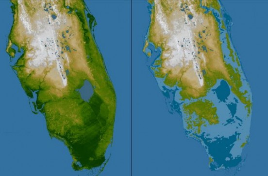
Better design: As a result of continued global warming, sea levels inevitably will rise. This is a huge issue in Florida. Allow for that when designing and deciding where to put things - airport runways, streets and port infrastructure, for example.
Energy-efficient buildings: This is one of the most cost-efficient improvements that could be made since it would last as long as the life of the building. To finance this, some sort of conservation bank could be used for low-interest loans. Payments could be offset by savings in electricity bills.
Embrace clean energy standards. For example, require utilities to make a certain percentage of their electricity from clean energy sources - wind, solar, nuclear or maybe natural gas. This should be phased in carefully so that consumers aren't socked overnight with higher energy costs.
Use education: Conservation can save money as well as energy. Show people how to save energy.
It's unfortunate that global warming deniers can exert enough political pressure to block badly needed reforms. But there are steps we can take today that don't require immersion in the controversy to make practical sense."
How Soon Is Now? A timely post on Real Climate: "Willie Soon is a name that pops up every so often in climate ‘debate’. He was the lead author on the Soon and Baliunas (2003) paper (the only paper that has ever led to the resignation of 6 editors in protest at the failure of peer-review that led to its publication). He was a recent speaker (from 37.20) at the 2011 Heartland Institute conference, and can be counted on to produce a contrarian take on any particular issue that anyone might care about – ranging from climate, to mercury in fish and polar bear population dynamics. Recently, there has been a renewed focus on how much money Willie Soon has taken from fossil fuel companies for his ‘research’ (over a $1 million dollars). While that is impressive, the real issue is not how he gets paid, but the quality of his science. The discussion last week about his finances did lead people to notice his publically accessible website where he has posted papers, emails, calculations and reviews going back to 2003. There is quite a lot of interesting stuff there, including a few curioustidbits."
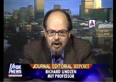
A Climate Change Dissenter Who Has Left His Mark On U.S. Policy. The New York Times has a story about Richard Lindzen, a PhD scientists at MIT who has been a long-time cheerleader of climate denial, with a long, rich history of advancing alternative theories to AGW (arguing that its not greenhouse gases, but changes in the sun or shifts in atmospheric water vapor: "BOSTON -- Richard Lindzen is 71. His career as professor of meteorology at Massachusetts Institute of Technology is winding down. The rumpled, bearded, soft-spoken scientist no longer teaches regular classes and looks forward to a quiet retirement a year from now, perhaps at his second home, in Paris. "Quiet" is not a word you could apply to his career. In the 1970s, he developed a mathematical analysis that disproved much of the accepted scientific theories about how "tides" in the Earth's atmosphere move heat around the planet. For that, he won a number of prestigious awards and was invited to become a member of the National Academy of Sciences at the tender age of 37. In the 1990s, when a group of climate scientists using computer-driven climate models and environmental groups asserted that climate change caused by man-made greenhouse gases would dangerously warm the Earth, Lindzen set out to disprove them. He lost that battle. The message of the computer modelers is now the prevailing wisdom of the National Academy and other distinguished scientific bodies around the world. But Lindzen hasn't given up. He became a major force in the political war that raged within the incoming George W. Bush Administration over what to do about global warming. After holding seminars with leading climate scientists, Bush rejected U.S. participation in the Kyoto Protocol to reduce greenhouse gas emissions."