
Next week may be the hottest of the summer for the central third of the USA.
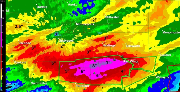
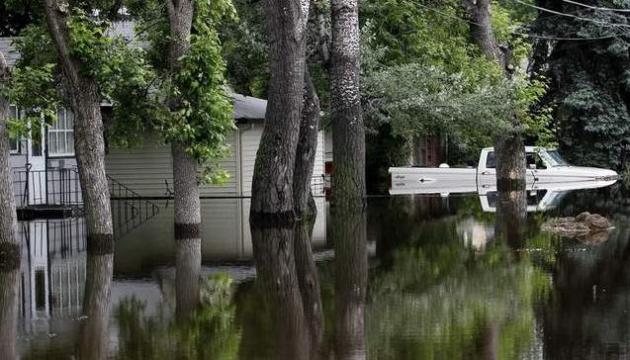
Friday Rainfall. Anywhere from 2-4" of rain fell yesterday from Alexandria into the far western suburbs of the Twin Cities to Mankato and Rochester, Minnesota, roughly 2-4 week's worth of rain. Click here to see more details.
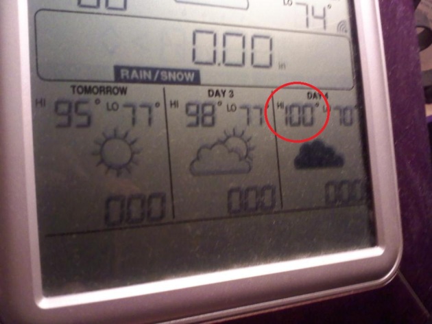
"Susie's Magic Weather Station". One of my friends and colleagues at WeatherNation, meteorologists Susie Martin, has a La Crosse Technology weather station at home. This thing is remarkably accurate - so much so that there are some days we toss out all the other model runs and go with "Susie's weather station". Glad we invested a few million dollars in state of the art weather technology. All we really needed was a $30 weather station. Ugh. Well, this remarkable little weather gizmo is predicting 95 Saturday, 98 Sunday and a sizzling 100 for the Twin Cities on Monday. With a dew point forecast to be in the 75 degree range that could translate into a heat index of 110-120. I suspect we'll see a lot of problems with heat-related ailments in the days to come. Please take the heat seriously.
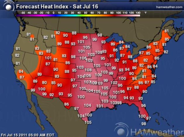
Saturday Afternoon Heat Index. Factoring temperature and dew point it will feel like 108 in the Twin Cities this afternoon, suffocating heat/humidity from the Upper Midwest southward to the Gulf coast. Map courtesy of Ham Weather.
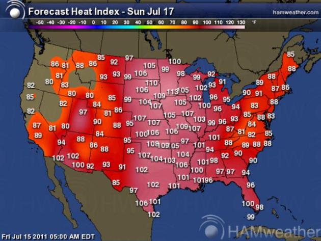
Sunday Heat Index. Sunday may be a few degrees hotter, an afternoon heat index ranging from 113 in the Twin Cities to 107 at Omaha, and almost reasonable 104 heat index at Dallas and 101 at New Orleans.
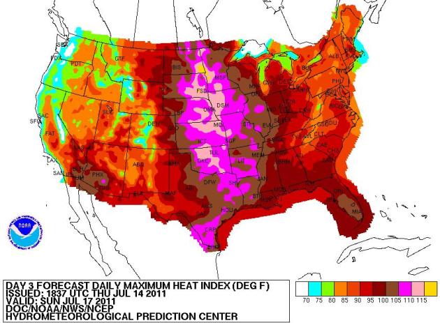
Sunday Heat Index. Good grief. Every new computer run seems to take the projected heat index up a few more notches. It may feel like 120 in the Fargo/Moorhead area Sunday afternoon, closer to 105-115 across the rest of central/southern Minnesota. The central third of the nation will bake from the weekend through at least Wednesday or Thursday of next week. Map source: NOAA NCEP.
...EXCESSIVE HEAT WARNING IN EFFECT FROM NOON SUNDAY TO 9 PM CDT
WEDNESDAY...

THE NATIONAL WEATHER SERVICE IN TWIN CITIES/CHANHASSEN HAS ISSUED
AN EXCESSIVE HEAT WARNING...WHICH IS IN EFFECT FROM NOON SUNDAY
TO 9 PM CDT WEDNESDAY. THE EXCESSIVE HEAT WATCH IS NO LONGER IN
EFFECT.

* TEMPERATURE...AFTERNOON HIGHS IN THE MID 90S WITH LOW
  TEMPERATURES AROUND 80 DEGREES.

* HEAT INDEX...AROUND 110 DEGREES IN THE AFTERNOON AND EARLY
  EVENING.

* IMPACTS...THESE HOT AND HUMID CONDITIONS WILL LEAD TO A
  HEIGHTENED RISK OF HEAT RELATED STRESS AND ILLNESSES.

PRECAUTIONARY/PREPAREDNESS ACTIONS...

TAKE EXTRA PRECAUTIONS IF YOU WORK OR SPEND TIME OUTSIDE. WHEN
POSSIBLE...RESCHEDULE STRENUOUS ACTIVITIES TO EARLY MORNING OR
EVENING. KNOW THE SIGNS AND SYMPTOMS OF HEAT EXHAUSTION AND HEAT
STROKE. WEAR LIGHT WEIGHT AND LOOSE FITTING CLOTHING WHEN
POSSIBLE AND DRINK PLENTY OF WATER.

TO REDUCE RISK DURING OUTDOOR WORK...THE OCCUPATIONAL SAFETY AND
HEALTH ADMINISTRATION RECOMMENDS SCHEDULING FREQUENT REST BREAKS
IN SHADED OR AIR CONDITIONED ENVIRONMENTS. ANYONE OVERCOME BY
HEAT SHOULD BE MOVED TO A COOL AND SHADED LOCATION. HEAT STROKE
IS AN EMERGENCY...CALL 9 1 1.

AN EXCESSIVE HEAT WARNING MEANS THAT A PROLONGED PERIOD OF
DANGEROUSLY HOT TEMPERATURES WILL OCCUR. THE COMBINATION OF HOT
TEMPERATURES AND HIGH HUMIDITY WILL COMBINE TO CREATE A DANGEROUS
SITUATION IN WHICH HEAT ILLNESSES ARE LIKELY. DRINK PLENTY OF
FLUIDS...STAY IN AN AIR-CONDITIONED ROOM...STAY OUT OF THE SUN...
AND CHECK UP ON RELATIVES AND NEIGHBORS.
Friday Record Highs: TEXAS
Dalhart TX 103
Dallas Fort Worth 107
Friday Record 24-Hour Rain
St. Cloud MN 1.74”
Meridian, MS 1.79”
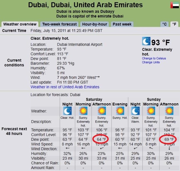
More Humid In The Twin Cities Than Dubai? The Friday afternoon dew point in Dubai (United Arab Emirates) was a steamy 81, but it's forecast to drop to 64 this afternoon, rising to 69 by Sunday afternoon. That compares to predicted dew points in Minnesota in the 75-80 range. Yes, more humidity than Dubai - just in case anyone asks. Forecast courtesy of timeanddate.com.
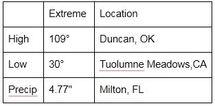
24 Hour Extremes From Around The USA
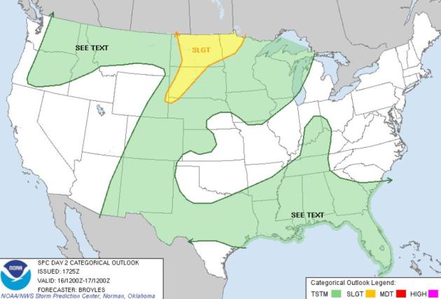
Saturday Severe Threat. It will actually be too hot for T-storms from the Upper Midwest across the Plains states, a slight chance of hail and damaging winds for the Dakotas and Red River Valley of northwestern Minnesota. Map courtesy of SPC.
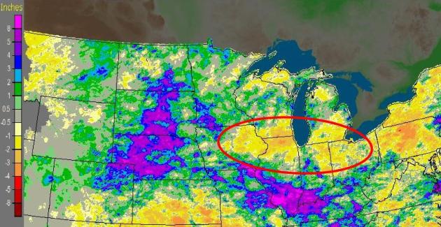
Fickle Rainfall Pattern. WGN's weather blog shows the 30-day departure from normal rainfall. Rainfall since mid June has been 3-8" above average over the central Dakotas and Nebrasa, as well as southern Illinois - parts of southwestern Minnesota have picked up 3-5" more rain than usual since June 15. But from the Quad Cities to Rockford, Milwaukee and Chicago it's been too dry, a (growing) rainfall deficit of 1-3".
Very Wet Start To July. Professor Mark Seeley has some useful information in his latest WeatherTalk blog: "July 10-11 (Sunday-Monday) brought more severe weather to parts of Minnesota. A tornado was reported in Meeker and Kandiyohi Counties and large hail was reported in Pipestone County. But the more widespread reports of severe weather included strong winds (50-90 mph) and some heavy rainfall, especially in west-central Minnesota's Pope, Douglas, and Stearns Counties where hundreds of trees were blown down. A more complete report of the wind damage can be found on the NOAA-National Weather Service web site....http://www.crh.noaa.gov/mpx/. Through the first 15 days of the month some areas of the state have already reported above normal July rainfall amounts. Some of these include:
6.37 inches at Melrose
6.06 inches at Lakefield
5.68 inches at Kimball
5.57 inches at Madison
7.77 inches at Worthington
4.64 inches at Sherburn
4.27 inches at Browns Valley
4.05 inches at Watson
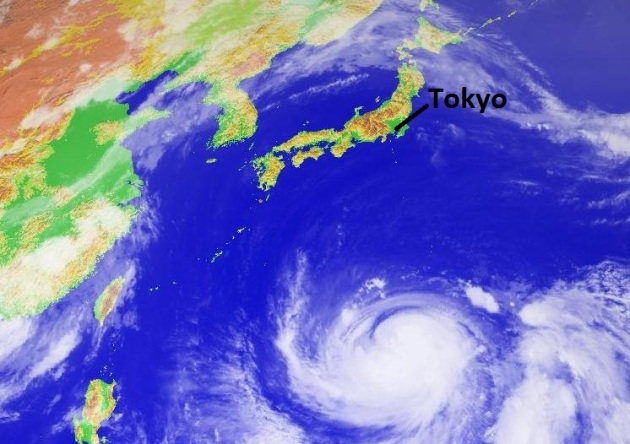
Typhoon Ma-On. Currently a category 3 hurricane, "Ma-On" is forecast to strengthen to near category 5 strength, with sustained winds possibly topping 150 mph, before weakening slightly before hitting Japan as early as Monday of next week. Right now projections call for Typhoon Ma-On to weaken into a category 3 hurricane before coming ashore. Right now a direct strike on Tokyo is not expected. More details:
- Current max sustained winds of 114 mph.
- equivalent to a Category 3 hurricane.
- Storm movement is likely to become northwesterly or even northerly by the end of the week.
- Typhoon Ma-On forecast to reach super typhoon status early next week, make landfall in southern Japan shortly afterward.
- winds forecast to hit 138 mph (strong Cat 4 hurricane).
- Greater Tokyo is unlikely to feel the worst of the storm, no matter its ultimate track. Still, flooding rain and damaging winds could take place in the early to middle parts of the week.
- Likewise, in northeastern Honshu, at the site of the March tsunami and nuclear disasters, there is the potential for heavy rain, high winds and rough seas next week.
- Storms like this can unload 10-20 inches of rain.
- danger for mudslides and flooding upon reaching Japan.


Japanese Tsunami Tour From Inside A Car. This is incredible HD footage, taken from inside a car that was swept up in Japan's spring tsunami. Amazingly, the windshield wipers keep working as the car bobs along through the wreckage, thousands of vehicles instantly transformed into reluctant boats: "Incredible HD footage from inside Yu Muroga's car as he was caught out by the tsunami that devastated Japan's north east coast, March 2011." Video courtesy of boreme.com. Love that URL.
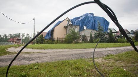
Severe Storms Batter Central Poland. An update from CTV News: "WARSAW, Poland — Heavy storms overnight in central Poland have blown the roofs off homes, cut power lines and flooded sections of a major highway. Traffic on highways linking Warsaw to the southern cites of Katowice and Wroclaw faced disruptions Friday, with some areas cut off fully because of flooding and the collapse of some sections of the roads. The storm felled trees, destroyed power lines and caused massive damage to hundreds of homes, farmhouses and other structures in many parts of the country."
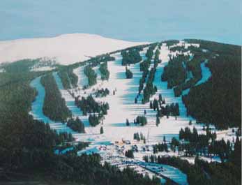
Ski Industry Sets All-Time Record: 60 Million Visits In 2010-2011. It was a record year for the skiing/snowboarding industry. A few details:
The National Ski Areas Association announced this week that - despite the nation's lingering economic slump - a new all-time record of 60.4 million skiers and snowboarders was recorded during the 2010-2011 season in the final Kottke End of Season Survey. Estimates are that 50,000 people took advantage of snow fun over the Fourth of July weekend. The industry hit the 60 million mark once before during the 2007-2008 season. What it means is that we skiers and snowboarders might give up eating, but we won't give up our sliding.'

Future Mt. Rushmore Fireworks Shows In Jeopardy. The problem? Beetles. Details:
- Officials at Mount Rushmore National Memorial say that as long as pine beetles are killing trees in the southern Black Hills, there likely won't be Fourth of July holiday fireworks shows.
- The annual July 3 show that started in 1998 has been canceled the past two years because of the fire danger that has resulted from the pine beetle infestation. Eliminating the pest is expected to take years and cost millions of dollars.
- Rushmore Superintendent Cheryl Schreier says the threat of fireworks starting a fire is too great a risk for the thousands of people who visit the monument for the Independence Day holiday.

GOP Bill Would Shift Bullet Train Money To Midwest Flood Relief. The L.A. Times has the story: "Jeopardizing $213 million promised to California, the House is poised to pass a bill that would divert money for high-speed rail projects around the country to Midwest flood relief. In a preview of the bitter partisan fights that lay ahead over ways to reduce the federal budget deficit, Democrats on Thursday protested a provision of a Republican-drafted spending bill that would rescind $2 billion in unobligated high-speed rail funds from the 2009 economic stimulus bill. A large chunk of that is money rejected by Florida’s governor for high-speed rail and awarded to California and other states after a fierce competition. Democrats accused Republicans of putting at risk projects that will provide jobs critical to the nation’s economic recovery. "The flooding that has occurred in our nation's heartland is being used as an excuse to eliminate an investment in our transportation network and our future," said Rep. Louise Slaughter (D-N.Y.). While many Republicans are cool to high-speed rail, a priority of President Obama’s, Republicans said the budget deficit made it necessary to shift the money to funding repairs to the widespread damage caused by this year’s heavy flooding. "We’ve got to make tough choices," said Rep. Steve Scalise (R-La.) "That means balancing a budget and not just saying everything can get all the funding it wants."

Weathering The Storms: Home Improvements Could Save Your Life. The Kansas City Star has a story about steps you can take to reinforce your home to make it more storm-proof. Considering there's a large and growing body of evidence that severe weather is on the increase, you might want to pay attention to some of these suggestions: "KANSAS CITY, Mo. - It can take seconds for a monster tornado to tear a stick-built Midwest house to shreds. But even much weaker winds have damaged regional residences this storm season. We've seen the destroyed roofs and broken windows that prove it. Fred Haan, a mechanical engineering professor at Rose-Hulman Institute of Technology in Terre Haute, Ind., builds 5-inch-tall houses with little holes drilled inside them -small-scale versions of our life-size abodes-to see how they fare versus tornadoes big and small. A giant simulating machine at Iowa State University creates twisters that are 3 feet in diameter. The models are typically demolished in seconds. "The main issue with houses in the Midwest is the lack of strong connections," says Haan, whose academic research helps lead to better storm-shielding products. Relying on gravity, roofs rest on walls sitting atop foundations, and there is nothing fastening those components together. Unfortunately, saving frame-construction houses from 200-mph winds that occur in EF-4 or EF-5 tornadoes , such as the May 22 Joplin tornado, is almost impossible. But there are steps to help strengthen houses so they can survive more than a 3-second gust of 90-mph wind, the standard to which most houses in the Midwest are built.
Roof: If you need to have your roof replaced, specify: Ring-shank nails . The design of a ring-shank nail resembles a screw, except that the head is flat.
Shingles: Look for materials rated by UL 2218 or FM 4473 as Class 3 or 4, which indicates they have been tested and found to stand up to increasing levels of hail damage. Also make sure the roof cover you choose is rated for the wind speed in your area. For example, shingles meeting the ASTM D 3161 Class F standard are rated for wind speeds up to 110 mph, while shingles meeting the ASTM D 7158 Class H standard are rated for wind speeds up to 150 mph."
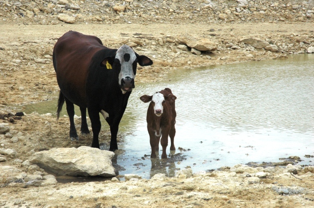
Cruel Paradox: Texas Drought Causing Cattle To Die From Too Much Water. An explanation:
- As with humans, water intoxication can occur when there's too much water in the body, which disrupts electrolyte balance in cells. Death can occur.
- Typically an average cow grazing green forage consumes as much as 8.4 gallons of water a day from it. This year, because drought precluded forage growth and there's been a relatively low intake of dry forage, daily water consumption is around 0.6 gallons.
- In addition to too much water, ranchers also must watch for dehydration in their animals and should regularly check on the quality of water from stock tanks that cattle use.
- Cattle will drink out of tanks where water quality suffers from high concentrations of salt, nitrates and other organic materials, but they're taking in less water because of the mix.
- Also, hot, sunny days can warm stagnant water and produce blue-green algae blooms, some species of which are toxic. Ingesting the algae or the toxins from them can be fatal.
- Weather forecasters predict the drought in Texas won't diminish until at least the end of September.

Study Shows Strong El Nino Can Bring Increased Sea Levels, Storm Surges To U.S. East Coast. BNO News has the story: "WASHINGTON, D.C. (BNO NEWS) -- Coastal communities along the U.S. East Coast may be at risk to higher sea levels accompanied by more destructive storm surges in future El Niño years, according to a new study by the U.S. National Oceanic and Atmospheric Administration (NOAA). The study, led by Bill Sweet from NOAA's Center for Operational Oceanographic Products and Services, was prompted by an unusual number of destructive storm surges along the East Coast during the 2009-2010 El Niño winter. The study examined water levels and storm surge events during the 'cool season' of October to April for the past five decades at four sites representative of much of the East Coast: Boston, Atlantic City, New Jersey, Norfolk, Virginia, and Charleston, South Carolina."
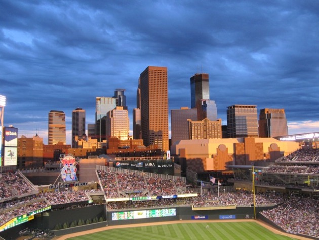
Does Cloudiness Affect The Outcome of Baseball Games? The Washington Post's always entertaining and informative Capital Weather Gang takes a look at that question. A few highlights:
- According to the first published study of its kind in the journal Weather, Climate, and Society, the influence of clouds on baseball can help/harm one team moreso than the other.
- Among the principal statistically significant results are:
- Cloudy skies benefit the batter while clear skies benefit the pitcher.
- Offensive production generally declines during clearer-sky games compared to cloudy-sky games.
- Batting averages increase under cloudy conditions.
- Pitching performance increases when skies are clear with strikeouts having the strongest response.
- The number of errors increases during clear-sky games (it’s also noted that errors increase during all daytime games when compared to games played at night).
- Fly outs and ground outs increase between clear- and cloudy-sky games.

- It’s so hot in Atlanta they’re carjacking ice cream trucks. One such vehicle was recovered, sans frigid treats, off Cascade Road.
- Another one only had its supply of ice cream stolen in the South Bend, IN, area. The owner of a fleet of ice cream trucks says it's only a matter of time before he finds a group of young kids responsible for a substantial ice cream heist from one of his trucks. They snatched popsicles and boxes of ice cream bars valued between 100 and 150 dollars.

48 Years Apart: Lightning Strikes Kill Dad, Son. This is a sad (and bizarre story) from WPVI-TV in Philadelphia: "HAMMONTON, N.J. - July 14, 2011 (WPVI) -- The story seems almost unbelievable, but the bark blown off an old sycamore tree is a reminder this tragedy is all too real. It was in a Hammonton backyard that 54-year-old Stephen Rooney was struck by lightning at a family barbeque July 3rd as he stepped away from the crowd to light a cigar. The party host, Rooney's cousin and next door neighbor, Funzi Digerolamo, says a giant bolt shook the yard. "Hit the tree, went up the tree. It electrified all through the root system of the tree at that time so he was standing right in the electric field," Digerolamo said. Digerolamo's son Scott was blown right off a bench, but survived. Steve Rooney died five days later. Just before he was hit, Rooney downplayed concerns about the lightning. "He had just said that lightning doesn't strike two people in one family right before it happened, not long before it happened, he said that," neighbor Paula Weisbecker said."

25,000 Airport Breaches Since 2001. CNN has a slightly terrifying story. Here's an excerpt:
"The nation's airports have suffered more than 25,000 security breaches since November 2001, according to a House committee, citing information it says it received from the Transportation Security Administration. The breaches -- amounting to about seven a day, or about five per year at every airport -- include everything from people who accidentally leave a bag on a checkpoint conveyor belt to those who purposefully evade security and get onto airplanes without proper screening. A TSA spokesman did not contest the figure, but questioned its significance, saying all breaches are investigated and resolved. The agency said it did not have a breakdown of breaches by severity. With about 25,000 of these incidents over a decade at more than 450 TSA-regulated airports, this amounts to just over five such incidents per airport per year, according to the TSA. The 25,000 breaches include:
-- 14,322 breaches into secure entries, passages or other means of access to the secure side of the airport.
-- Approximately 6,000 breaches involving a TSA screener failing to screen a passenger or a passenger's carry-on property, or doing either improperly."
Before We Go (hey, if local TV stations can do it, so can I...):


Best Album Covers. Do you still have any vinyl lurking in the attic or basement? Me neither. But virusoflife.com has a collection of some of the funniest album art you'll ever see. Click here, if you dare: "So this is a list of the best album covers I have ever seen. When I say “best” I mean weird, creepy, scary and anything but something I would ever consider purchasing. This list is in no particular order simply because each of these is pretty damn strange in its own way and rating them against each other is just not possible. So, let’s begin!"
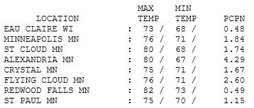
Super-Soggy Friday Across Minnesota. Clouds and storms kept temperatures cooler on Friday, highs mostly in the 70s. Rainfall amounts ranged from 1.74" at St. Cloud to 1.84" at MSP International Airport, to 2.6" at Eden Prairie, a whopping 4.29" at Alexandria, more than 5 week's worth of rain in 24 hours.

"Heat Spike"
The Small Cooler Advisory has been upgraded to a full-blown Hot Vinyl Car-Seat Warning. And to think, 4 months ago we were still driving on frozen Minnesota lakes. When the sun does decide to come out temperatures will soar to 92-96 statewide. The dew point should rise into the upper 70s to near 80, creating a (ghastly) Heat Index in the 105-115 range from the Twin Cities and Des Moines southward to the Gulf coast.
When there's this much water in the air your body can't cool itself effectively by evaporating sweat off your skin. It's easy to overheat, especially infants, the elderly (and pets kept outside). Take the heat seriously in the coming days; I have a strong hunch next week will be the hottest of summer for the central USA.
Climate Stories...
Climate Stories...

Global Weirding: Get Ready For 21st Century Revolutions In Climate, Politics And Religion. The story from Business Insider: "If the green movement hasn’t done much for the planet lately, it has given us some cool new expressions. One of the best is “global weirding,” the trendy new way of branding the apocalypse formerly known as global warming. It combines the virtue of "climate change" (which is that anything from deep freezes and record blizzards to ferocious hot spells and droughts can be held up as evidence) with the catchiness of global warming. Not bad. And unlike some green scare propaganda, the global weirding hype is actually true—although more about the human rather than about the natural world. Politics, economics, international relations, religion: Everything in our world is getting weirder, and the weirding is happening faster all the time. These are the best of times and the worst of times in ways that would blow Charles Dickens’ mind."

Global Warming Extends Ragweed Allergy Season. The story from Newswise: "Feel like there’s no end in sight when it comes to fall allergy misery? Blame global warming. Research suggests that with global warming, nasal allergy during the ragweed pollen season – also called hay fever or seasonal allergic rhinitis – lasts up to three weeks longer than it used to, and the further north you live, the longer you have to wait for relief. Considered the most allergenic of all pollens, ragweed pops up in the Eastern and Midwest states everywhere starting in mid-August. One plant alone can produce up to one billion pollen grains, and each grain can travel more than 100 miles. To help the one in 10 Americans affected by the sniffling, sneezing and itching of ragweed allergies, the American College of Allergy, Asthma and Immunology (ACAAI) and its allergist members suggest following these six steps:
1. Get a jump start – Mark your calendar to remind you to take medication before ragweed allergy symptoms start. Mid-August is when the plant blooms in most of the country, but it’s a little later in the South.
1. Get a jump start – Mark your calendar to remind you to take medication before ragweed allergy symptoms start. Mid-August is when the plant blooms in most of the country, but it’s a little later in the South.