16 days this summer with a dew point of 70 or higher in the Twin Cities.
214 hours with a dew point over 70 so far this summer in Minneapolis/St. Paul. That's 50 hours more than the Twin Cities normally see all summer long! Yes, America's summers
are becoming more humid.
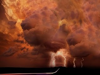
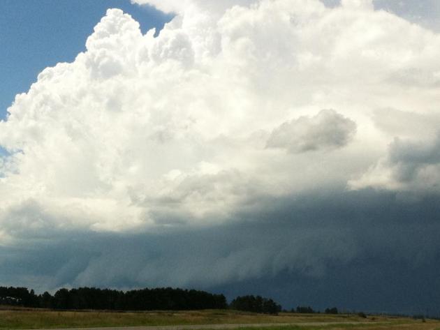
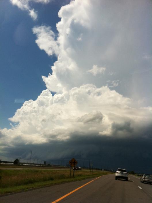
Cumulonimbus. Yesterday I drove through torrential rains near Little Falls, Minnesota. Less than 3% of Minnesota saw rain yesterday. Somehow I managed to drive right into this tropical thunderstorm.
"...
Here in 2011, the average dew point since June 1st has been 59.6 F, which is a little over 4 degrees above normal. In July the moisture has been even more pronounced. The average dew point this month through the 27th has been 64.5 F. This is actually higher than the normal July low temperature." - from the local MSP National Weather Service, details below.
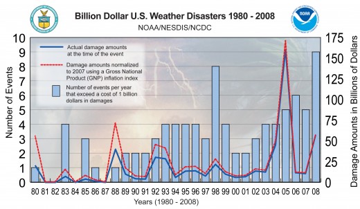
"...Since roughly 1980, the United States has seen a total of 107 weather-related disasters of over $1 billion each in damage, with total losses exceeding $750 billion."
"....The economic impact of severe weather events is only projected to grow," Senator Dick Durbin said at a hearing of the Senate Subcommittee on Financial Services and Government, which he chairs. "We are not prepared. Our weather events are getting worse, catastrophic in fact." - Reuters article on extreme weather. Details below.
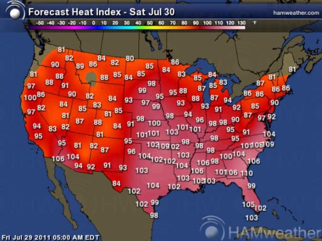
Sweltering Saturday. The combination of 90-100 degree heat and dew points in the 70s will make it feel like 100-110 from the central Plains to the Carolinas. Slight relief is forecast for New York, Philadelphia and Washington D.C, while Dallas experiences its 29th day/row above 100 degrees (air temperature). Map courtesy of Ham Weather.
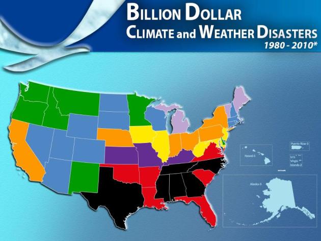
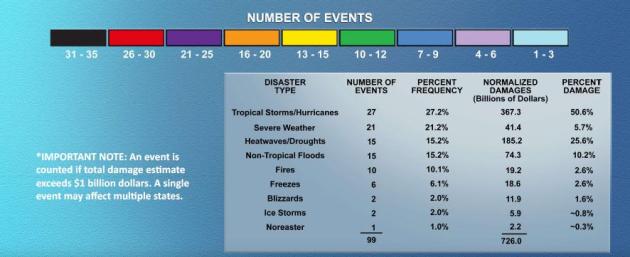
Billion Dollar Disasters Since 1980. The most dangerous part of the USA (in terms of the sheer number of billion dollar weather disasters) is the southern and southeastern U.S. - vulnerable to floods, tornadoes and hurricanes. Texas and Mississippi have seen more than 3 times more (billion dollar) disasters since 1980 than Minnesota. The safest states (from the standpoint of natural disasters) are Hawaii and Alaska. In the lower 48 the risk is lowest from the Great Lakes into northern New England. Source: NOAA's
NCDC, the National Climatic Data Center.
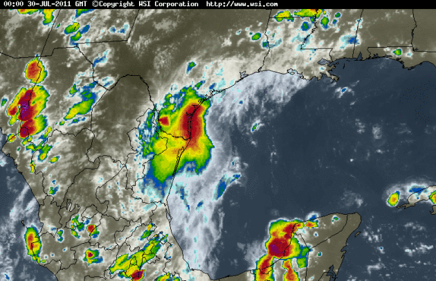
Don Fizzles. The enhanced IR satellite loop (courtesy of WSI) shows Don weakening rapidly over far southern Texas - now just a tropical depression, incapable of dropping the kind of rain that Texas needs to pull out of one of the Lonestar State's worst droughts in history.
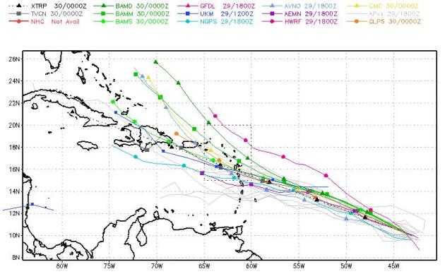
Emily? Another potential tropical cyclone is brewing in the Carribean. I have a hunch we'll be tracking Tropical Storm Emily within 72 hours, a potential threat to the Lesser Antilles, and eventually the U.S. Virgin Islands and Puerto Rico. Map courtesy of
NOAA.
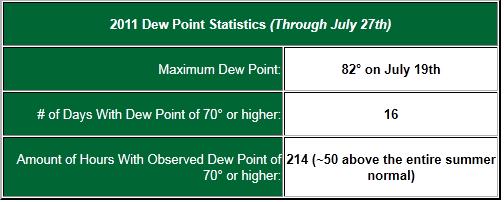
High Dew Points This Summer With An Official Record Dew Point On July 19th. Yes, it's been a VERY humid summer across the great state of Minnesota - a potentially record-setting summer in terms of dew points and humidity levels. Here's an excerpt from a
post from the local NWS Office:
"Using the Twin Cities climate records since 1980, the normal number of days each year with dew points of 70° F or higher is 23. The all-time record year for dew points of 70° F or higher is 2002 with 48 days. Courtesy of the Minnesota State Climatology Office.
Here in 2011, the average dew point since June 1st has been 59.6°, which is a little over 4° above normal. In July the moisture has been even more pronounced. The average dew point this month through the 27th has been 64.5°. This is actually higher than the normal July low temperature.
Dew Points and Severe Thunderstorms
Dew point often directly correlates to deeper atmospheric moisture and instability, two parameters that are conducive for severe thunderstorms in the presence of some type of weather front. Thus meteorologists often look at dew point as one of the key elements in forecasting severe weather potential. Indeed, the dew point during some of the area's severe weather events this year was quite high, over 9° above the 2011 summer average so far.
President Obama Declares A Major Disaster For Minnesota Following Severe Storms.
Hometownsource.com has the full story: "
Washington, D.C. The U.S. Department of Homeland Security’s Federal Emergency Management Agency (FEMA) announced that federal disaster aid has been made available on an order from President Obama to Minnesota and ordered federal aid to supplement state and local recovery efforts in the area struck by severe storms, flooding, and tornadoes during the period of July 1-11, 2011. Federal funding is available to state, tribal and eligible local governments and certain private nonprofit organizations on a cost-sharing basis for emergency work and the repair or replacement of facilities damaged by the severe storms, flooding, and tornadoes in the counties of Chisago, Isanti, Kandiyohi, Lincoln, Lyon, McLeod, Meeker, Mille Lacs, Pine, Pipestone, Redwood, Renville, Stearns, and Yellow Medicine, and the Mille Lacs Band of Ojibwe. Federal funding is also available on a cost-sharing basis for hazard mitigation measures for all counties and tribes within the state."
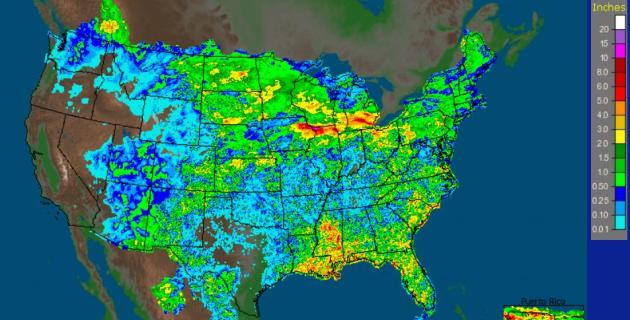
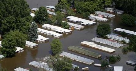
Record Rains Soak U.S. Midwest, Prompting More Flood Fears. The
NOAA map above shows rainfall in just the last week, more than 5 from eastern Iowa into northern Illinois and southern Michigan.
Reuters has the story of how tropical heat and dew point levels are resulting in record rains (and subsequent flooding): "
Overnight storms dumped a record amount of rain on parts of the Midwest, including more than 10 inches falling on Dubuque, Iowa, prompting fears of more Mississippi River flooding. The hardest hit area appeared to be the Mississippi River town of Dubuque, Iowa, where more than 10.3 inches fell over the past 24 hours, prompting officials to close the city's flood wall along the river, which has risen over two-and-a-half feet since Wednesday. The storm, which was accompanied by spectacular thunderstorms that lit up the night skies like a Fourth of July fireworks display, triggered numerous lightning strikes in Dubuque. One bolt "knocked off" a section of an apartment building, according to Dubuque Fire Chief Dan Brown."We did call in all personnel, the first time in my career that I remember that we've called all hands," Brown said."
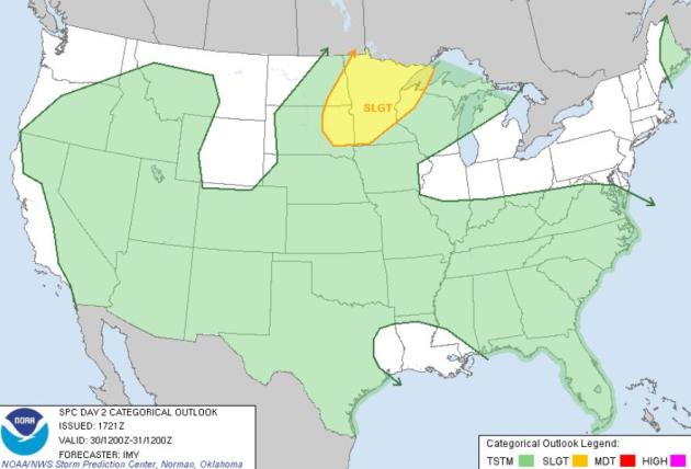
Saturday Severe Risk. A few storms may exceed severe limits across the eastern Dakotas and Minnesota later today, wind gusts over 58 mph and/or hail larger than 1" (quarter-size) in diameter, according to SPC.
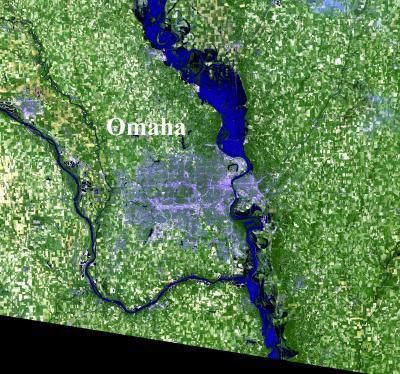
Flood Relief A Month Away. Satellite image of Omaha flooding courtesy of
sciencecodex.com. A 5-6 month flood on the Missouri River? It's looking that way.
Omaha.com has the details: "
Local officials say they are about a month away from feeling more comfortable with the flooded Missouri River now that they know the schedule for cutting releases from upstream reservoirs. The river is expected to drop below flood stage at Omaha by mid-to-late September, according to Friday's long-awaited announcement by the Army Corps of Engineers. But metro officials say conditions should begin improving much sooner. “It's good news,” said Council Bluffs Mayor Tom Hanafan, where the homes of 30,000 people are at risk if a levee breaks. Based on the corps schedule, Bluffs officials calculate the river could drop off the city's levees within about a month. “We're doing everything humanly possible and financially possible to hold those levees,” Hanafan said. “Do I have perfect confidence? I can't say that. I can say this, I feel more confident today than I did when we started.” Communities and businesses have been battling flooding since late May. In Omaha, Marty Grate of the public works department said the city could open some flood gates in about a month, allowing rainwater to drain more normally."
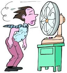
Heatwave Facts: Expect A (Much) Higher Electric Bill This Month. Here is some fascinating information from
Planalytics, a weather firm in the Philadelphia area that assesses the impact of weather trends on various weather-sensitive businesses:
"The excessive heat that enveloped much of North America during the last half of July has certainly caused a variety of short-term impacts for businesses and consumers. Companies that sell air conditioners, fans, cold beverages, swimwear and other similar products have benefited from a surge in demand. On the other hand, consumers looking to beat the heat scaled back on certain products, services and activities.
As the extreme heat subsides and more normal summer temperatures return, there are some longer-term, lasting effects that the recent weather will have on the economy.
August Electricity Bills = Higher Costs & Reduced Spending Power
Planalytics’ Power Weather Index (a measure that isolates the impact of temperatures on electric demand) is showing the following for the U.S. as a whole:
- +2% vs. July 2010 (Note: last year was the second warmest July in 50 years!)
- +6% vs. the 10-year average
- Many metropolitan areas in the Midwest & Northeast saw even larger increases during the last half of the month (St. Louis +16%, Chicago +14%, Cleveland +11%, Philadelphia +11% vs. the 10-year average)
"Recent 'brown outs' in New York, Texas and parts of Midwest are evidence of how much the power grid struggled to keep pace with record demand for electricity as day after day air conditioners were working away at full blast," commented Paul Corby, Senior VP Planalytics Energy. "The cost of power hit all-time highs in the North East and Midwest and came close to highs in other parts of the country."
Economic impacts for households and businesses include:
- Significantly higher August utility bills will claim a greater share of household disposable income leaving fewer dollars to spend on dining out, back-to-school shopping, etc.
- For many, disposable income has already taken a hit with unplanned purchases of air conditioners and fans or repair/servicing costs for home and car air conditioners that malfunctioned under the strain of heavy use.
- Higher electricity bills will increase manufacturing costs for many businesses, putting upward pricing pressure on finished goods sold at retail.
For many areas in the country, the heat wave lasted only a week or two, but in a difficult economy where consumer spending is already fragile, the ramifications of those 100 degree days will be longer lasting."
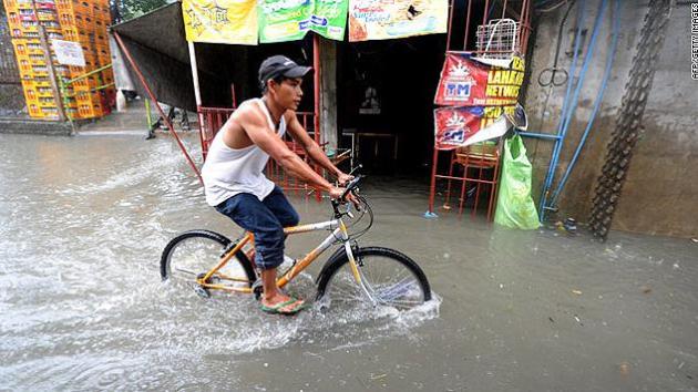
Slow-Moving Tropical Storm Kills 27 in Philippines. The truth: tropical storms can be just as destructive as hurricanes (in terms of rainfall potential). Slow-moving storms that temporarily stall out after coming ashore pose the greatest threat. The story from
CNN: "
A tropical storm moving through the Philippines on Wednesday has killed 27 people and left more than 60 injured or missing, according to a government disaster response agency. Hours after Tropical Storm Juaning made landfall along northern Aurora province, the country's National Disaster Risk Reduction and Management Council began rescuing stranded people and searching for fishermen swept away by powerful waves. The slow-moving storm continues to drag through northern parts of the island nation at about 10 mph (16 kph). It is expected to cross into parts of the Northern Luzon island Wednesday night, the agency said. Though winds have decreased slightly, the agency warned against gusts of up to 60 mph. The government has been tracking the storm since it intensified from a depression Monday."
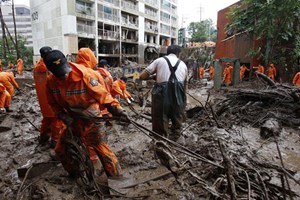
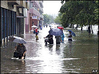
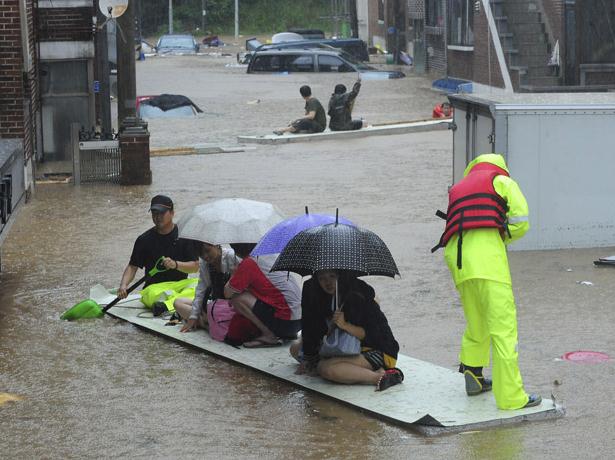
Dozens Killed In South Korea Floods, Landslides.
UPI has more details: "
SEOUL, July 29 (UPI) -- Record-breaking rains in South Korea set off landslides and floods that killed at least 59 people and left another 10 missing, officials said Friday. Rescue workers were joined by volunteers from across the country in massive humanitarian and cleanup efforts in Seoul and neighboring areas in the aftermath of record rains totaling nearly 2 feet this week. The Yonhap News Agency said rains were the heaviest in a century and left about 10,000 people from 4,800 households in Seoul and Gyeonggi Province homeless. About 2,000 people in nearby Paju and other areas were evacuated from their homes because of fears of flooding, authorities said. Landslides swept through homes, apartment buildings and roads." (photo courtesy of
3news.co.nz).
Thousands of Buildings Destroyed As Heavy Rainfall, Flooding Hits North Korea.
Wireupdate.com has the story: "
PYONGYANG (BNO NEWS) -- 'Thousands' of buildings have been destroyed in various parts of North Korea after it was hit by heavy rainfall and flooding this week, state-run media reported on Friday. Details about casualties are unknown. The Korean Peninsula was hit by record rainfall this week, causing flooding and landslides in both North and South Korea. At least 67 people are believed to have been killed in South Korea alone, and officials fear the death toll could still rise. In North Korea, where news gathering by foreign journalists is nearly impossible, state-run media reported that large areas of the country were 'seriously affected' by the weather. It is the third time in a month that severe weather in North Korea caused extensive damage. According to the Hydro-meteorological Service in North Korea, 564 millimeters (22.2 inches) of rain was recorded in the county of Chongdan in South Hwanghae province alone between midnight Tuesday and noon Thursday. Similar amounts of rain hit other parts of the country." (photo courtesy of the BBC).
The Difficulty With Predicting The Weather. Canada's
National Post has the story: "
BEVERLY HILLS, Calif. — Hindsight isn’t just 20/20. Where weather forecasting is concerned, it’s easier to explain what just happened than it is to predict what’s going to happen next. We’re living in an age, the weather experts say, where it’s becoming tougher to predict what the weather is going to do this afternoon, let alone tomorrow or next week. The world’s weather is changing. Case in point: Earlier this week, U.S. National Weather Association meteorologist and storm tracker Jim Cantore, and tropical weather and hurricane science analyst Dr. Rick Knabb, faced reporters to talk about the Weather Channel’s approach to covering extreme weather. On the very same day, torrential rains inundated much of South Korea, triggering flash floods and landslides that killed at least 34 people, according to early news reports. As of this past week, Seoul had received 850 millimetres of rain this month alone, following a June in which 450 millimetres of rain fell. Last year, the city received less than 400 millimetres of rain in June and July combined. According to Weather Channel programming president Bob Walker, 2011 is fast becoming the most volatile, extreme year on record. On Groundhog Day, “literally a third of the U.S.” was gripped in one of the most severe winter storm systems on record. Chicago was buried under 20 inches of snow; Chicago schools closed for the first time in 12 years."
Meet KOIN-TV's New Weathercaster: Fabio. O.K. Here's one way to amp up the ratings.
TV Spy and Gawker have all the (thoroughly ripped) details and a video clip you won't be able to get out of your brain, no matter how hard you try: "
Locked in a staggeringly handsome internet duel with original Old Spice guy Isaiah Mustafa, new Old Spice spokesman Fabio stopped by Portland’s KOIN this week to forecast the weather (video above). “It’s very sunny today,” the fledgling weathercaster reported, “and it feels so nice on Fabio’s skin.”
Wall Cloud. I was driving north on 371 between Royalton and Little Falls yesterday, and saw a lowering, rotating wall cloud under a developing thunderstorm (that produced torrential rain and small hail).
A Little Perspective
People get a lot of grief for living in Minnesota, where we originate much of the weather coverage for "WeatherNation". I sure do. My dad in Lancaster, PA (my hometown) asks, "How can you SURVIVE up there during the winter - don't you all go nuts?" The short answer is yes. Minnesotans are all a little mad for not packing up our stuff and fleeing south. Winters are challenging, but it could be worse. No earthquakes, volcanoes or Texas-size hurricanes.
Minnesota has seen 10-12 billion dollar weather disasters since 1980. Texas and much of the southeast (vulnerable to hurricanes, floods & tornadoes) has seen more than 3 TIMES more billion dollar disasters, according to NOAA.
And don't let anyone in Dallas give you an earful: DFW has endured 28 days/row above 100, and it may get even hotter next week (107 in the shade).
Tropical Storm Don fizzles over south Texas today; not the drought-busting storm some were hoping for. Emily may be forming in the eastern Caribbean, still well east of the U.S. Virgin Islands. Looks like we're heading into a much more active tropical pattern now.
Climate Stories...
Weather Disasters Seen As Costly Sign Of Things To Come.
Reuters has a must-read article on the accerating rate of (costly) weather extremes across the USA: "
As of June, the United States has seen eight weather disasters exceeding $1 billion each in damage, and the annual hurricane season has hardly begun, said Kathryn Sullivan, Assistant Secretary of Commerce for Environmental Observation and Prediction and NOAA's Deputy Administrator. The record is nine in a single year, 2008. But April alone saw separate tornado, wildfire, flood and drought disasters. "Any one such a event in a year would be considered quite notable, and we had four in totally different hazard categories in the space of a month," Sullivan told Reuters. The costs of weather-disaster damages have climbed past $32 billion for 2011, according to NOAA estimates. The agency also projects that water flowing into the Gulf of Mexico from record flooding will create the largest-ever "dead zone" from pollutants led by run-off from agricultural chemicals, threatening marine life and threatening the $2.8 billion annual commercial and recreational fisheries."
Climate Change Debunked? Not So Fast. LiveScience has an interesting read. Here's an excerpt: "
New research suggesting that cloud cover, not carbon dioxide, causes global warming is getting buzz in climate skeptic circles. But mainstream climate scientists dismissed the research as unrealistic and politically motivated. "It is not newsworthy," Daniel Murphy, a National Oceanic and Atmospheric Administration (NOAA) cloud researcher, wrote in an email to LiveScience. The study, published July 26 in the open-access online journal Remote Sensing, got public attention when a writer for The Heartland Institute, a libertarian think-tank that promotes climate change skepticism, wrote for Forbes magazine that the study disproved the global warming worries of climate change "alarmists." However, mainstream climate scientists say that the argument advanced in the paper is neither new nor correct. The paper's author, University of Alabama, Huntsville researcher Roy Spencer, is a climate change skeptic and controversial figure within the climate research community."
"Misdiagnosis Of Surface Temperature Feedback.
RealClimate has the complete story; here's an excerpt: "
The hype surrounding a new paper by Roy Spencer and Danny Braswell is impressive (see for instance Fox News); unfortunately the paper itself is not. News releases and blogs on climate denier web sites have publicized the claim from the paper’s news release that “Climate models get energy balance wrong, make too hot forecasts of global warming”. The paper has been published in a journal called Remote sensing which is a fine journal for geographers, but it does not deal with atmospheric and climate science, and it is evident that this paper did not get an adequate peer review. It should not have been published. The paper’s title “On the Misdiagnosis of Surface Temperature Feedbacks from Variations in Earth’s Radiant Energy Balance” is provocative and should have raised red flags with the editors. The basic material in the paper has very basic shortcomings because no statistical significance of results, error bars or uncertainties are given either in the figures or discussed in the text. Moreover the description of methods of what was done is not sufficient to be able to replicate results. As a first step, some quick checks have been made to see whether results can be replicated and we find some points of contention. The basic observational result seems to be similar to what we can produce but use of slightly different datasets, such as the EBAF CERES dataset, changes the results to be somewhat less in magnitude. And some parts of the results do appear to be significant. So are they replicated in climate models? Spencer and Braswell say no, but this is where attempts to replicate their results require clarification. In contrast, some model results do appear to fall well within the range of uncertainties of the observations. How can that be? For one, the observations cover a 10 year period. The models cover a hundred year period for the 20th century. The latter were detrended by Spencer but for the 20th century that should not be necessary. One could and perhaps should treat the 100 years as 10 sets of 10 years and see whether the observations match any of the ten year periods, but instead what appears to have been done is to use only the one hundred year set by itself."
Climate Scientists Debunk Latest Bunk By Denier Roy Spencer. Joe Romm at
Climate Progress has the details: "
Long wrong climate science disinformer Roy Spencer has published another deeply flawed article. That ain’t news. What is news is that the deniers have a couple of new tricks up their sleeves. First, the disinformers have figured out they should focus on journals that don’t seem to have a very deep understanding of climate science. In May, it was a paper in a statistics journal, which was ultimately withdrawn because of “evidence of plagiarism and complaints about the peer-review process.” This time it’s an article in the open-access Remote Sensing co-authored by Spencer. It bears repeating that Spencer committed one of the most egregious blunders in the history of remote sensing — committing multiple errors in analyzing the satellite data and creating one of the enduring denier myths, that the satellite data didn’t show the global warming that the surface temperature data did. It also bears repeating that Spencer wrote this month, “I view my job a little like a legislator, supported by the taxpayer, to protect the interests of the taxpayer and to minimize the role of government.”
Cool Dudes: Climate Denial Among Conservative White Males. Here's a post from
Discover Magazine: "Someone had to say this eventually, and now,
someone has. It has been apparent for a while (at least anecdotally) that conservative white men (CWM) in the U.S. are more prone than the average bear towards climate change denial. Now, based on new research by social scientists Aaron McCright and Riley Dunlap, we have the figures to back that up, including the following:
— 14% of the general public doesn’t worry about climate change at all, but among CWMs the percentage jumps to 39%.
— 32% of adults deny there is a scientific consensus on climate change, but 59% of CWMs deny what the overwhelming majority of the world’s scientists have said.
Nation's Climatologists Exhibiting Strange Behavior.
The Onion has the (very funny) "story", clueless anchors and all: "
For some reason, climatologists have been running around in an agitated state, waving their little arms and squawking about "global warming."