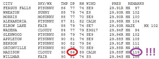
119 F: highest heat index ever recorded in the Twin Cities (July 11, 1966).
125 F: highest heat index in the state of Minnesota (at the airport in Red Wing, at 3 pm on July 30, 1999, when a temperature of 97 combined with a dew point of 84)
* thanks to the University of Minnesota climatologist, and climate historian Charles Fisk.
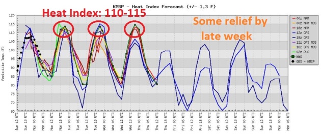
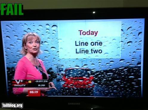
Where exactly are we living again? Yesterday felt like Bangladesh - with pine trees. Temperatures shot up into the 90, a dew point near 80 typical for Fiji or Dubai but Minnesota? Hardly. It felt like 100 to 110 - and the next couple of days promise to be the hottest of summer. By Wednesday the air temperature may reach 100°. Throw in a dew point near 75 and it may feel like 115 later this week, the Danger Zone. Yes, this will probably be the hottest week of summer
And no, you're not imagining it: America's summers are becoming more human. Not significantly hotter, at least not yet, but in recent decades there has been a trend toward higher dewpoints, and for a number of reasons. A warmer atmosphere can hold more water vapor, and as we discussed last week, improved farming practices now allow farmers to plant corn rows closer together, which releases more water into the air at night through a process known as "evapotranspiration." Something is putting more water into the air above and beyond what the Gulf of Mexico can provide. More fuel = a potential for more severe storms, more hail, and a greater potential for flash flooding. Welcome to the new normal here in Minnesota.
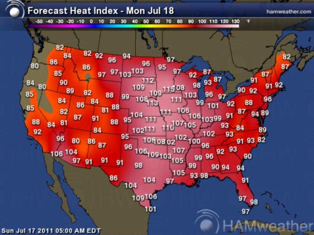
- Dangerous, Prolonged Heat Wave began last weekend, will spill over into much of this week.
- From Norman Heat statement (useful statement for days ahead): “...PEOPLE NEED TO REMAIN DILIGENT TO STAY SAFE DURING PROLONGED HEAT...”
- Parts of at least 13 states in Heat Advisories/Watches/Warnings.
- At least 38 of the lower 48 states will be impacted by 90°+ weather this weekend into next week.
- The prolonged period of 90+ heat forecast for NE WI next week could be longest since mid July 2006.
AN EXCESSIVE HEAT WARNING IS IN EFFECT FOR MUCH OF CENTRAL AND SOUTHERN MINNESOTA... INCLUDING THE TWIN CITIES... AND ADJOINING AREAS OF WEST CENTRAL WISCONSIN... THROUGH 9 PM ON WEDNESDAY. AN EXCESSIVE HEAT WARNING BEGINS FOR THE REMAINDER OF WEST CENTRAL WISCONSIN THIS AFTERNOON AND WILL REMAIN IN EFFECT THROUGH 9 PM ON WEDNESDAY. AFTERNOON HEAT INDICES WILL EXCEED 105 DEGREES FOR SEVERAL HOURS EACH AFTERNOON... WITH OVERNIGHT LOW TEMPERATURES ONLY FALLING INTO THE MIDDLE 70S TO LOWER 80S.
THE COMBINATION OF HOT TEMPERATURES AND HIGH HUMIDITY WILL COMBINE TO CREATE A DANGEROUS SITUATION IN WHICH HEAT ILLNESSES ARE LIKELY. DRINK PLENTY OF FLUIDS... STAY IN AN AIR-CONDITIONED ROOM... STAY OUT OF THE SUN... AND CHECK UP ON RELATIVES...NEIGHBORS... AND PETS.
AN EXCESSIVE HEAT WARNING REMAINS IN EFFECT UNTIL 9 PM CDT WEDNESDAY.
* TEMPERATURE...AFTERNOON HIGHS IN THE LOWER TO MIDDLE 90S WITH
LOW TEMPERATURES IN THE MIDDLE TO UPPER 70S.
* HEAT INDEX...105 TO 115 DEGREES IN THE AFTERNOON AND EARLY
EVENING.
* IMPACTS...THESE HOT AND HUMID CONDITIONS WILL LEAD TO A
HEIGHTENED RISK OF HEAT RELATED STRESS AND ILLNESSES.
PRECAUTIONARY/PREPAREDNESS ACTIONS:
TAKE EXTRA PRECAUTIONS IF YOU WORK OR SPEND TIME OUTSIDE. WHEN POSSIBLE... RESCHEDULE STRENUOUS ACTIVITIES TO EARLY MORNING OR EVENING. KNOW THE SIGNS AND SYMPTOMS OF HEAT EXHAUSTION AND HEAT STROKE. WEAR LIGHT WEIGHT AND LOOSE FITTING CLOTHING WHEN POSSIBLE AND DRINK PLENTY OF WATER.
TO REDUCE RISK DURING OUTDOOR WORK... THE OCCUPATIONAL SAFETY AND HEALTH ADMINISTRATION RECOMMENDS SCHEDULING FREQUENT REST BREAKS IN SHADED OR AIR CONDITIONED ENVIRONMENTS. ANYONE OVERCOME BY HEAT SHOULD BE MOVED TO A COOL AND SHADED LOCATION. HEAT STROKE IS AN EMERGENCY... CALL 9 1 1.
AN EXCESSIVE HEAT WARNING MEANS THAT A PROLONGED PERIOD OF DANGEROUSLY HOT TEMPERATURES WILL OCCUR. THE COMBINATION OF HOT TEMPERATURES AND HIGH HUMIDITY WILL COMBINE TO CREATE A DANGEROUS SITUATION IN WHICH HEAT ILLNESSES ARE LIKELY. DRINK PLENTY OF FLUIDS... STAY IN AN AIR-CONDITIONED ROOM...STAY OUT OF THE SUN...
AND CHECK UP ON RELATIVES... NEIGHBORS... AND PETS.
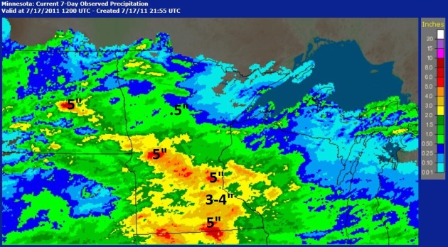
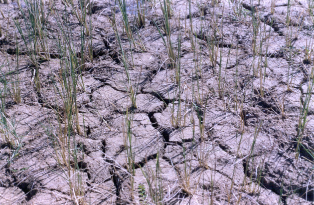 Record Drought. According to data from the Oklahoma Mesonet, the last 365 days were the driest July 15-July 14 period on record in Oklahoma. In other words, the July 15, 2010 through July 14, 2011 statewide average precipitation total of 22.99 inches is drier than any other July 15-July 14 period dating back to 1921.
Record Rain:
Apalachicola, FL 5.8”
Pensacola, FL 4.39”
Record Highs:
Pensacola, FL 4.39”
Record Highs:
Gaylord, MI 94
Alpena, MI 97
Fort Lauderdale, FL 97
Miami, FL 97
Record Low:
New Bern, NC 63Alpena, MI 97
Fort Lauderdale, FL 97
Miami, FL 97
Record Low:
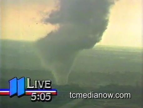
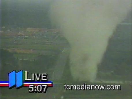
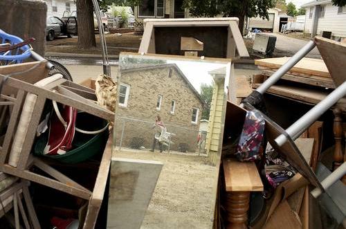
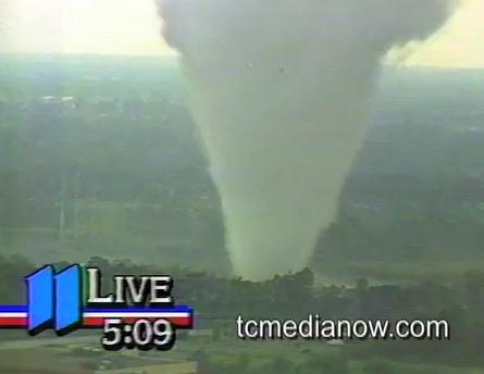
The Brooklyn Park tornado helped to put KARE-TV on the map. We showed viewers that we could cover the news better than WCCO and KSTP, at least during a big breaking weather story. There was a rumor that WCCO tried to get their helicopter pilot in the air, and he refused, as any sane pilot would probably have done. A couple of days later, during the Aquatennial Parade KARE-11 had the good sense to put the chopper, Max Messmer, and Tom Empey on a float. They got a standing ovation through the streets of Minneapolis. This may have been the most-watched, most photographed tornado in history. it almost seemed like the tornado wanted to have its picture taken. 25 years later there hasn't been a comparable tornado, one that enabled a TV news helicopter to totally circle the twister "safely", with no hail, severe lightning, turbulence or dangerous debris nearby.
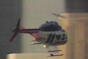
"Gyro-Zoom" Lens. Talk about the planets aligning. On the day Sky11 pilot Max Messmer was heading out to cover a different story, he just happened to have a). NPPA award-winning photographer Tom Empey onboard and b). an experimental "gyro-zoom" lens. That allowed for the smooth zooms into the tornado, no jittery/shaky video - amazingly smooth zooms and pans that took coverage to an entirely new level. Thanks to KARE-11 and Tom Oszman, who created TCMedia Now, an amazing on-line library of broadcast TV video clips going back many decades. If you haven't checked it out yet, do yourself a favor and see what he's created. Truly bookmark-worthy.
A few more random thoughts about the tornado:
1). This was a freak event. There were no watches/warnings in effect at the time – nothing from SPC, I don’t think we were even in a "slight risk" area.
2). It was oppressive: temp of 91 with a dew point close to 80. The CAPES must have been over 4,000 that afternoon – incredible instability, but NO wind shear to speak of. It just goes to show that you can still get a moderate tornado (without any wind shear) if the upward motion/instability is severe enough, as it was that day.
3). About 4:50 someone in the newsroom yells out “there’s a funnel cloud over Brooklyn Park!” At first I thought it was a bad joke, I told them to shut up. But they were insistent, said that Sky11 was about to send back live pictures. We all raced into the studio and were SHOCKED when the live video feed came up showing a rope tornado forming. Max Mesmer (Sky11 pilot) had been on his way to another story, saw the wall cloud forming, and immediately raced toward the developing tornado – didn’t get permission from KARE-11 management. He just did it on his own.
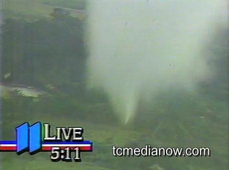
4). The tornado appears white much of the time because the sun was shining on the funnel.
5). There was very little lightning, virtually no hail to speak of, on radar (not Doppler, btw) you can see a classic hook. Because winds aloft were virtually nonexistent that thing sat over the Springbrook Nature Center, just chewed it up, like a massive vacuum cleaner. I assumed it was at least moving at 10-20, but it was stationary most of the time.
6). Smooth video from the chopper. Sky11 pilot Max Mesmer had a photographer onboard, Tom Empey, who was testing a new piece of hardware called a “gyro-zoom lens”. All the stations have them now for their choppers, but at the time they were extremely rare. We were lucky that Tom had one of these gyro-zooms – it’s one of the reasons why the video was so good.
7). Max circles the tornado – I keep pleading with him to be careful and “stay a safe distance away from the tornado”. I was scared to death that a tree limb would fall through the rotor blades and bring the chopper down.
8). At one point Paul Magers asks where Max is. There’s a long pause as Max takes the chopper down to treetop level, he READS A STREET SIGN, before rising back up to altitude to radio in his exact location. I think Max got into some trouble with the FAA for that move. But again, Max was fearless. The first thing photographer Tom Empey did when Sky11 landed was stumble out and KISS THE GROUND!
9). The tornado lasted about 35 minutes, give or take. It was a weak F-2 tornado, winds up in the 95-120 mph range. There were no serious injuries or fatalities, which is miraculous.
10). This may have been the most-watched tornado, certainly live, in Minnesota history. A few hundred thousand people were watching on KARE-11. Channel 4’s (reportedly) helicopter pilot refused to go into the air to cover the tornado. I can't say I blame him.
11). A few days later KARE-11 put the chopper, Max and Tom on a float in the Aquatennial Parade in Minneapolis. The float got a standing ovation as it passed by. People were blown away by the coverage. This event, more than anything I can remember, really put KARE-11 on the map, it showed viewers that 11 could cover the news. This was the start of the big ratings turnaround.
12). I got numerous requests for the raw footage from scientists at SPC and NSSL – there were many papers written on the tornado, and calculated wind speeds/circulation within the funnel.
13). The planets lined up: we had a chopper in the area, with a gyro-zoom lens, and an award-winning photographer, a chopper pilot with NO FEAR who probably didn’t even realize the danger he was in (he was about ¼ to ½ mile away from the funnel). The tornado was nearly stationary, which allowed him to totally circle the storm from every angle. No hail, little or no lightning. I don't think there has been a similar tornado/helicopter encounter since...
It almost seemed like the tornado WANTED to have its picture taken!
* What happened to the Springbrook Nature Center, which bore the brunt of the July 18, 1986 twister? The Star Tribune has a follow-up story on regrowth and rebirth at the park. A very good read.
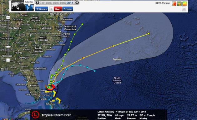
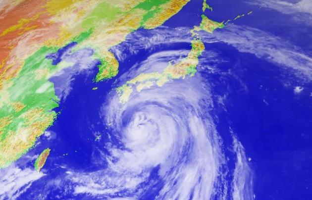
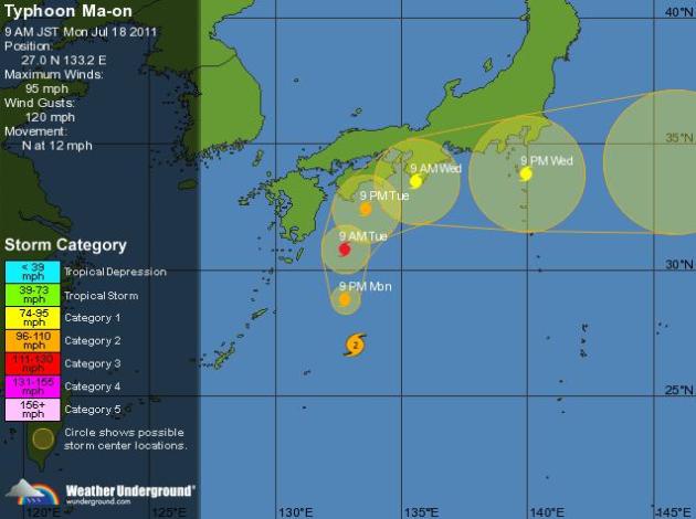
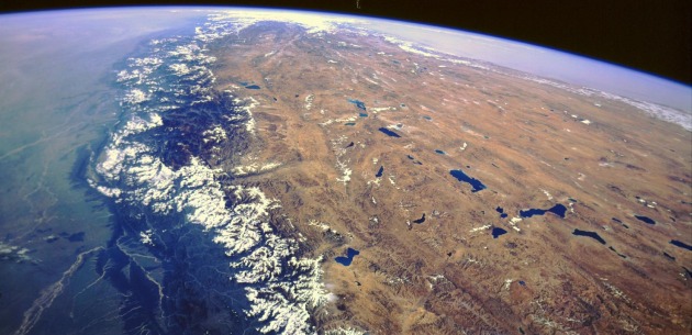
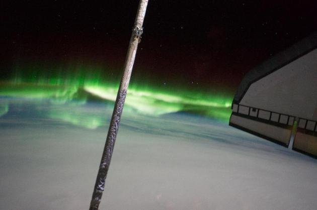 Photo Of The Day. This panoramic view was photographed from the International Space Station toward Earth, looking past space shuttle Atlantis' docked cargo bay and part of the station, including a solar array panel. Photo was taken as the joint complex passed over the southern hemisphere. Aurora Australis or the Southern Lights can be seen on Earth's horizon and a number of stars also are visible. Image courtesy of NASA.
Tropical Storm Bret. 2-4" rains are predicted for the northern Bahamas, but Bret is forecast to veer rapidly into the Atlantic, not a threat to the coastal USA.
Bret's Track. One of NHC's storm models brings Brett right up the east coast, the majority of solutions whisk this tropical storm, packing 40 mph sustained winds, quickly out to sea. Map courtesy of NHC and Ham Weather.
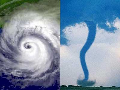
Typhoon Ma-On. This typhoon (same thing as a hurricane) is forecast to gradually weaken as it approaches the east coast of Japan over the next 36 hours. According to Bloomberg, TEPCO officials are rushing to shield the crippled nuclear reactors from wind and rain.
Ma-On Track. According to the Weather Underground and the JMA, the Japan Meteorological Agency, Ma-On is forecast to weaken to a category 1 storm before impacting the Osaka/Tokyo area, still capable of 10-15" rains.

"Leo". We lost our dog a few months ago - Max had been part of the family for 15 years. Over the weekend we drove to Chicago to pick up another Cavalier King Charles Spaniel, "Leo", who is a distant relative of Max. Yep, we're dog-people, and we're thrilled to have a new addition to our family.
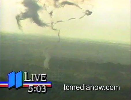
Posing For The Camera
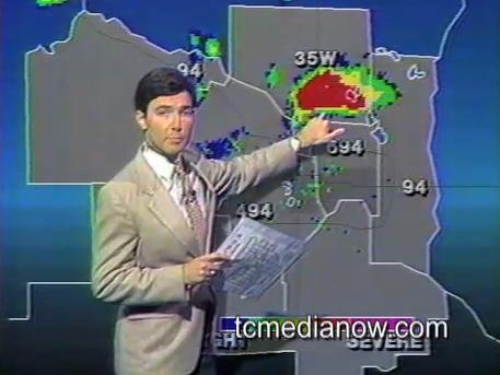
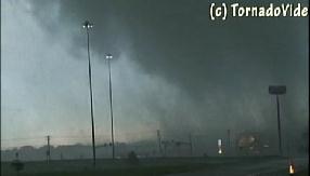
"There are flashes on the high tension wires - this is really spectacular!" KARE-11's chopper pilot, Max Messmer, reported during a wild (live) 5p pm newscast on July 18, 1986. With no warning an F2 tornado formed over the Springbrook Nature Center in Brooklyn Park, televised live during KARE-11's newscast. An atypical tornado: no wind shear, but enough instability to support a white tornado funnel that pulled trees out of the ground like weeds; a live feed for the entire tornado. Every time KARE-11 lost the live shot they'd come back to me, in front of the radar, a dazed expression on my face. It was surreal. Scientists have been studying the footage for 25 years; more memories on my blog.
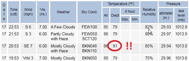
I'm trying not to think about the heat: 6 more days above 90 for the central USA, 100 not out of the question on Wednesday. The dew point hit 81 Sunday in the Twin Cities, typical for the Amazon (or Guam); making it feel like 105-110. More debilitating heat is on tap this week, probably the hottest week of summer.
Infants and the elderly, and people who are ill or on certain medications, are most at risk. Slow down, stay hydrated, and try to avoid the afternoon sun. Relief? Models are hinting at a cooler front by Sunday.
Climate Stories...

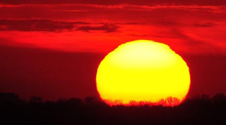
Could The Sun Save Us From Global Warming? Salon poses the question: "During the summer months, it's both difficult and remarkably easy to forget how dangerous the sun can be. Sometimes it takes a space weather event to reinforce the point. Last month, the Solar Dynamic Observatory recorded a massive eruption on the sun's surface that produced a mushroom cloud of ionized particles. Had the resulting solar winds struck the Earth's magnetic field directly, the damage to our electrical grids might have proven catastrophic. If you think our politicians have a tough time agreeing on debt ceilings, just imagine how much difficulty they'd have figuring out how to finance trillion-dollar repairs to our country's infrastructure. As astronomy author Bob Berman's new book reveals, storms like these are actually a common byproduct of the Sun's 11-year cycle of pulsing, dimming and brightening. "The Sun's Heartbeat," which takes its title from this phenomenon, offers a compelling and surprisingly playful history of our solar system's most famous star -- from the alternately brilliant and misguided theories of the ancient Greeks, to the modern-day discoveries that would make Arthur C. Clarke and Stanley Kubrick blush. Along the way, Berman, a columnist for Astronomy magazine and the science editor of the Old Farmer's Almanac, examines how solar cycles can offset global warming and how mankind has, by its own ambitions and neuroses, devolved into a collection of sun-starved troglodytes."
Mountaineers See Dramatic Climate Change In the Himalayan Region. A few first-hand observations reported by The Hindu: "Since 2007 the ice pinnacles in the Everest area have reduced in height and at the advanced base camp, there has been flowing water in the climbing season, a clear indication that ice is melting. “You no longer have to melt ice to drink water,” says Dawa Steven Sherpa. He too noted that the Imja lake was growing bigger. It is upstream of the Everest Base Camp and above major village settlements. “Imja and its potential threat are in the forefront of everyone's mind since the devastation could be huge,” he fears. Unpredictable weather is making climbing risky but that did not seem to stop 506 climbers, including 219 sherpas, getting to the top of Mt. Everest in 2011. “Rockfall is increasing and I have seen it break a leg. Ice avalanches are also dangerous.” However, we are getting good at judging the mountain and we know it so well now which is why there are fewer deaths,” says Dawa Steven Sherpa. Motup Chewang of Rimo Expeditions said major changes had swept the Karakoram Range as well in the last 20-30 years. The glaciers were retreating much faster and huge glacial lakes were forming there. Central east Bhutan also had a large glacial lake and it could be seen from satellites. Even near the Everest base camp some large cornices were disappearing. The Khumbu glacier had retreated by at least a couple of km."

More Climate B.S. At Forbes: Hiding The Energy Imbalance Of The Planet. Climate scientists are upset with Forbes, an otherwise reputable publication that has been (allegedly) reporting a fair amount of climate-nonsense in recent months. Peter Gleick, a water and climate scientists, and President of the Pacific Institute has a retort to a recent Forbes story at Huffington Post: "On July 1st, I published a blog entry here about climate distortions and misrepresentations at Forbes, which regularly publishes biased and misleading opinion pieces on climate issues. That entry described a remarkable piece by serial climate science conjurer Patrick Michaels and showed his clear misrepresentation of data on food production and climate risks. This falls well into the category of climate B.S. (bad science). While I have no misconceptions about the likelihood of Forbes trying to apply any error-checking or fact checking to these opinion pieces, I was somewhat astounded to read today another piece by Michaels on the Forbes site, in which he makes even more egregious and outrageous claims and errors. In this new piece, Michaels poses and then tries to answer a rhetorical question: "Why Hasn't The Earth Warmed In Nearly 15 Years?" I am not going to go into the detail of why his specific arguments in his opinion piece are wrong, self-serving, or serious misinterpretations of good, peer-reviewed science. Why? Because his fundamental premise -- his initial rhetorical question -- is wrong. Very simply, the Earth has warmed over the past 15 years. Significantly. Michaels' essay is like trying to prove why the sun goes around the Earth. Or why gravity doesn't work. Or how the U.S. faked the moon landing. It doesn't matter what his arguments are: his initial premise is wrong.