326 days since the last U.S. tropical storm landfall (Hermine in 2010), otherwise 711 since Claudette in 2009 (source: @angelafritz)
Tropical Storm Don may strengthen into a strong tropical storm (sustained winds of 60-70 mph) before coming ashore near Corpus Christi, Texas tonight.
28 days. Today the mercury should top 100 again in Dallas, for the 28th day in a row.
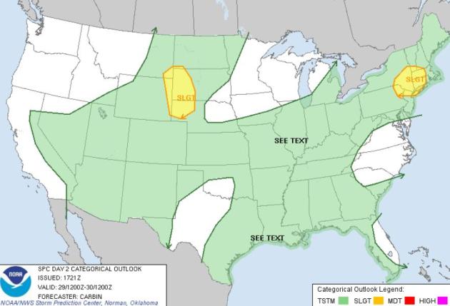
Friday Severe Threat. SPC expects fewer severe storms today, one risk area from the Poconos to New York City, northward to Albany and Worcester, MA - a second area over western Nebraska and the Black Hills of South Dakota.
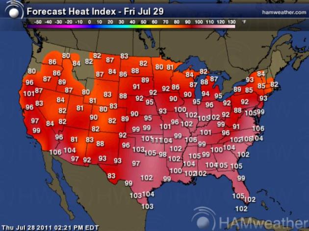
The Hot & Sweaty United States of America. I feel like Bill Murray in the movie, "Groundhog Day". Cue the music from Sonny and Cher. Good grief: more 100+ heat indexes predicted from the southern and central Plains to the east coast. Washington D.C. is expecting a high of 101, with an afternoon heat index in the 105-110 range, considerably hotter than Phoenix and Las Vegas (because there will be 2-3 times more water in the air). Map courtesy of Ham Weather.
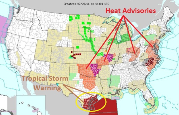
Sweltering Heat. NOAA has issued Heat Advisories from Dallas (where today should be the 28th day/row above 100) to Kansas City, Cincinnati, Ohio, and a huge swath of the east coast, from South Carolina to the Philadelphia area. Excessive Heat Warnings are posted for eastern Oklahoma and the St. Louis area, an Excessive Heat Watch for Charlotte and Raleigh, North Carolina. Click here to see the latest watches and warnings from NOAA.
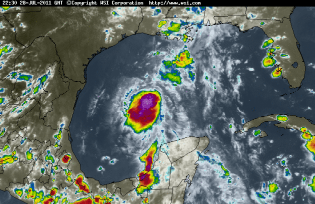
Tropical Storm Don Stats:
LOCATION...24.7N 92.5W
ABOUT 370 MI...600 KM SE OF CORPUS CHRISTI TEXAS
ABOUT 325 MI...520 KM ESE OF BROWNSVILLE TEXAS
MAXIMUM SUSTAINED WINDS...50 MPH...85 KM/H
PRESENT MOVEMENT...WNW OR 290 DEGREES AT 14 MPH...22 KM/H
MINIMUM CENTRAL PRESSURE...998 MB...29.47 INCHES
* satellite loop courtesy of WSI.
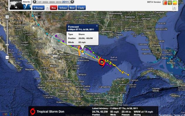
Don's Projected Path. None of the models strengthen Tropical Storm Don to hurricane status before reaching the Texas coastline sometime tonight. Too much wind shear aloft (shredding the storm's circulation) and too much dry air over the western Gulf of Mexico for rapid intensification. Don will probably come ashore near Corpus Christi as a strong Tropical Storm. According to NHC and Ham Weather, sustained winds are forecast to be close to 63 mph by 8 pm this evening as the storm comes ashore.
- A Tropical Storm Warning is in effect for the Texas coast from San Luis Pass to the mouth of the Rio Grande.
- General motion is expected to continue until landfall late Friday or early Saturday.
- Only slight strengthening is anticipated before the center reaches the Texas coast. A gradual weakening should begin thereafter.
- Tropical storm wind conditions are expected within the warning area by late Friday.
- A storm surge will raise water levels by as much as 1 to 2 feet above ground level, mainly along the immediate coast near and to the northeast of where the center makes landfall. Near the coast, the surge will be accompanied by large and damaging waves.
- Don is expected to produce total rain accumulations of 3 to 5 inches from the central Texas coast westward into south central Texas, with possible isolated maximum amounts of 7 inches
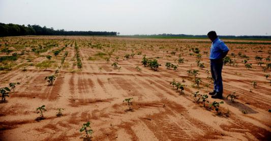
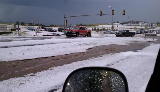
Don NOT A "Drought-Buster". Rainfall from Tropical Storm Don may put a dent in the 3rd largest drought in Texas history, but it won't rain long enough (or hard enough) to totally alleviate the "exeptional" drought, now impacting 75% of the Lonestar state, an area 3.5 times larger than the state of Georgia. Photo courtesy of the New York Times.
- Tropical Storm Don, now moving across the Gulf of Mexico toward the Texas coast, is not potent enough to break the ongoing Texas drought, says Texas State Climatologist John Nielsen-Gammon.
- “It’s been so dry in Texas for so long, this one storm will be a drop in an empty bucket,” says Nielsen-Gammon, who is a professor of atmospheric sciences at Texas A&M University in addition to serving as the state climatologist for Texas.
- “For rainfall potential, it doesn’t really matter whether or not it becomes a hurricane,” says Nielsen-Gammon. ”Hurricanes are windier, but they’re not rainier. Some of Texas’s worst floods have come from tropical storms or tropical depressions.”
- “Don is forecast to keep moving northwest after making landfall. So it should produce a broad swath of moderate rain rather than a concentrated flood.”
- The National Weather Service’s Hydrometeorological Prediction Center (HPC) is forecasting 3″ to 5″ in a 100-mile-wide swath along the path of the storm after it makes landfall. Precipitation amounts are expected to decrease as it moves farther inland.
- Nielsen-Gammon warns that some flooding is not out of the question. “It’s always possible that an individual cluster of thunderstorms will end up stalling or regenerating over one particular area and produce a localized flood event.”
- What does Don mean for the Texas drought? ”Unfortunately, Don is a fairly small storm at this point,” Nielsen-Gammon says. “The majority of the state will probably receive little or no rainfall. The drought is going to continue.”
- Don would have to dump about two and a half inches across all of Texas to prevent the state from having its driest January through July on record, according to statistics compiled by Brent McRoberts of the State Climate Office.
- “The lucky areas, if they receive 2″ to 5″ of rainfall, will be picking up one or two months’ worth of precipitation,” Nielsen-Gammon says. “That’s not enough to end the drought, but it will help reduce irrigation demands and perhaps let struggling ranchers produce another cutting of hay.”
- Don might even be bad news for some, according to Nielsen-Gammon. “The area around Victoria and Corpus Christi has been suffering, but they’ve managed to get just enough rain at just the right times to produce some decent crops. Right now, according to Texas AgriLife Extension Service, part of The Texas A&M University System, the cotton harvest is under way. If Don dumps a bunch of water on cotton that’s about to be harvested, it will hurt rather than help.”

Gulf Oil Producers Cut Output Due To "Don".
- Gulf of Mexico producers reduced oil and natural gas output on Thursday as Tropical Storm Don churned northwest toward the Texas Coast.
- Although Don has cut a small 7 percent of U.S. Gulf of Mexico crude output and 3 percent of natural gas output according to government data by midday Thursday, analysts said the storm's relative weakness and position in the Gulf of Mexico made it unlikely to cause prolonged production outages or energy infrastructure damage.
- But analysts and meteorologists said output cuts were precautionary and Don isn't likely to cause platform damage or affect output for long.
- Gulf Coast refiners reported no cuts in crude processing, but several said they were closely monitoring Don or taking steps to ensure plants were prepared for severe weather.
- In oil exporter Mexico, production has not been affected so far, although state oil firm Pemex is monitoring Don and has convened its emergency response team.

Thursday Record Highs:
- Wichita, KS: 107 Old record: 105 in 1910, 1980
- Joplin, MO: 104 Old record: 102 in 1952
- Bluefield, WV: 90 (tie) Old record: 90 in 1993
- Alamosa, CO: 89 (tie) Old record: 89 in 1995

Subject: Record Dew Point Temperature and Heat Index Value for the Twin Cities - July 19, 2011
Date: July 28, 2011
From: State Climatology Office - Minnesota Department of Natural Resources (DNR)
Contact: Greg Spoden 651-296-4214, gregory.spoden@state.mn.us
The National Weather Service Forecast Office (NWS) in Chanhassen and the DNR State Climatology Office have conferred on last week's extraordinary dew point temperatures in the Twin Cities. It was agreed that the 82 degree F dew point temperature value reported at 3:00 PM and again at 4:00 PM on Tuesday July 19, 2011 at the Twin Cities International Airport will be considered by these offices as the highest dew point temperature ever recorded in the Twin Cities. It is known that July 19 dew point temperatures exceeded 82 degrees F at moments between the routine hourly observations. However, in the interest of historical consistency and practicality in establishing future records, only hourly dew point temperature measurements were utilized to determine the new record. Heat index values on July 19 were extraordinarily high. The 4:00 PM observation may have tied or set an all-time heat index record for the Twin Cities. The air temperature reported at that hour was 95 degrees F and was paired with the 82 degree F dew point temperature. In the next few weeks, the heat index formula used by the NWS hourly "Weather Roundup" product will be used with the historical hourly air temperature/dew point temperature data set to create a heat index climatology. Another announcement will be sent when this is completed.
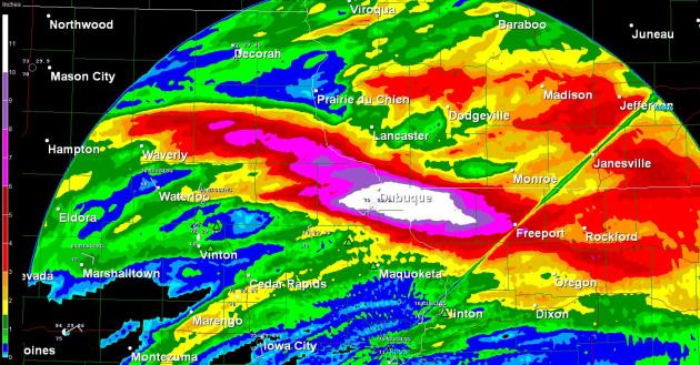
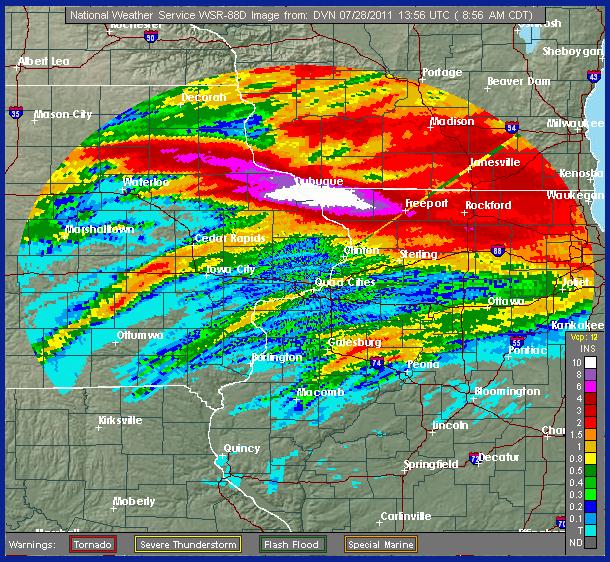
Impressive rainfall totals across NW Illinois/NE Iowa:
13.45" in Galena, IL
14.50" 4 miles south of Dubuque
10.31" at the Dubuque Airport
14.50" 4 miles south of Dubuque
10.31" at the Dubuque Airport
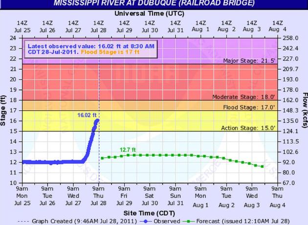
- Mississippi river at Dubuque rose 4 feet in 12 hours.
- Areas of Dubuque are reporting rain totals as high as 14.33” over 12 hours (6pm last night to 6am this morning).
- Residents in the East Dubuque Flats area are being asked to evacuate after 4 to 5 feet of water has risen in many areas.
14.3" Rain: Not A New Iowa State Rainfall Record. Here is an e-mail from the Iowa State Climatologist:
"The 14.3 inch total was not from an official location thus would not qualify for the state record. Iowa’s official 24-hour state record rain amount is 13.18 inches set at Atlantic on June 14, 1998. The unofficial record is 20.70 inches set at Boyden on September 18, 1926. There was an official total of 13.45 inches overnight at Galena, Illinois. Thus the unofficial 14.3 total certainly looks possible. Most locations make only one rain measurement per day. Thus whatever amount they had when they make their regular daily measurement will be their official 24-hour total. However, a very few official locations maintain continuous records and the Dubuque Airport happens to be one of those. As of 11:18 CDT today they have a 24-hour total of 10.62 inches. The current rain event began at the Dubuque Airport at 5:53 p.m. CDT yesterday. Thus any more rain they have today (until 5:52 p.m.) will add to their official (though preliminary) 24-hour total."
Harry Hillaker
Iowa State Climatologist

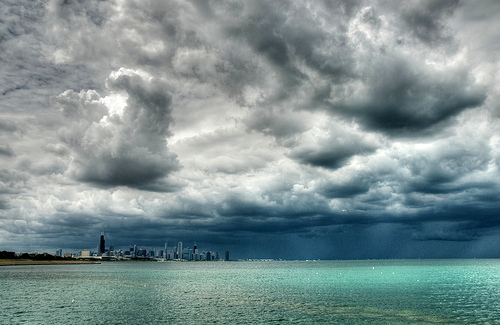
Chicago: Wettest July On Record. Photo courtesy of flickr. More details on a very soggy month in the Windy City:
- With more rainy weather on the way, the record is expected to keep climbing, forecasters said. "Ten inches isn't out of the question," said Andrew Krein, a meteorologist with the National Weather Service.
- Wednesday's storms, which were accompanied by lightning and strong wind gusts, initially knocked out power to about 69,000 ComEd customers, according to the utility.
- Continuing rainfall overnight raised that total to about 82,000. But by 6 a.m. repair crews had reduced that number to 69,000 once again.

Hurricane Basics From NOAA. Here's a good overview of hurricanes:
Each year, an average of eleven tropical storms develop over the Atlantic Ocean, Caribbean Sea, and Gulf of Mexico. Many of these remain over the ocean and never impact the U.S. coastline. Six of these storms become hurricanes each year. In an average 3-year period, roughly five hurricanes strike the US coastline, killing approximately 50 to 100 people anywhere from Texas to Maine. Of these, two are typically "major" or "intense" hurricanes (a category 3 or higher storm on the Saffir-Simpson Hurricane Scale).
What is a Hurricane?
A hurricane is a type of tropical cyclone, which is a generic term for a low pressure system that generally forms in the tropics. The cyclone is accompanied by thunderstorms and, in the Northern Hemisphere, a counterclockwise circulation of winds near the earth's surface. Tropical cyclones are classified as follows:
| * Sustained winds A 1-minute average wind measured at about 33 ft (10 meters) above the surface. ** 1 knot = 1 nautical mile per hour or 1.15 statute miles per hour. Abbreviated as "kt". |
Tropical Depression
An organized system of clouds and thunderstorms with a defined surface circulation and maximum sustained winds* of 38 mph (33 kt**) or less
An organized system of clouds and thunderstorms with a defined surface circulation and maximum sustained winds* of 38 mph (33 kt**) or less
Tropical Storm
An organized system of strong thunderstorms with a defined surface circulation and maximum sustained winds of 39-73 mph (34-63 kt)
An organized system of strong thunderstorms with a defined surface circulation and maximum sustained winds of 39-73 mph (34-63 kt)
Hurricane
An intense tropical weather system of strong thunderstorms with a well-defined surface circulation and maximum sustained winds of 74 mph (64 kt) or higher."
An intense tropical weather system of strong thunderstorms with a well-defined surface circulation and maximum sustained winds of 74 mph (64 kt) or higher."
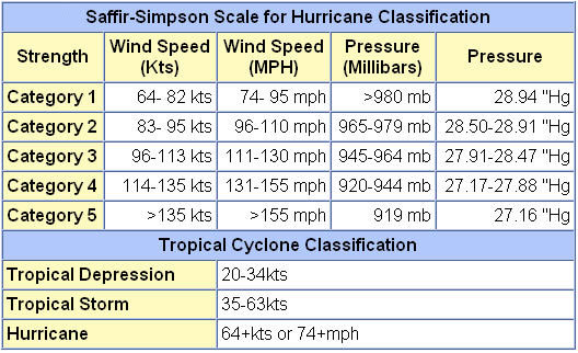
Saffir-Simpson Scale For Rating Hurricanes. None of the models strengthen "Don" to hurricane status before reaching landfall sometime late tonight or early Saturday. Here are more details (than you ever wanted to know) about the Saffir-Simpson scale, courtesy of NOAA.

How To Talk About Hurricanes To Your Kids. FEMA has a good resource for children: you certainly want your kids to have a healthy respect for these Texas-size storms, without traumatizing them. Here are a few basics: "Hurricanes are severe tropical storms that form in the southern Atlantic Ocean, Caribbean Sea, Gulf of Mexico, and in the eastern Pacific Ocean. Hurricanes gather heat and energy through contact with warm ocean waters. Evaporation from the seawater increases their power. Hurricanes rotate in a counter-clockwise direction around an "eye." Hurricanes have winds at least 74 miles per hour. When they come onto land, the heavy rain, strong winds and heavy waves can damage buildings, trees and cars. The heavy waves are called a storm surge. Storm surges are very dangerous and a major reason why you MUST stay away from the ocean during a hurricane warning or hurricane."


Outlook: More "Dog Days"
Can we go a few days without any weather drama? Thursday was a close call: over 14" rain (4 month's worth) soaked Dubuque, Iowa; the Mississippi rose 4 feet in a few hours. Over 10" rain has soaked Chicago this month; the wettest July on record. And "Don" is bearing down on Texas. Dry air & wind shear will probably prevent Don from becoming a strong hurricane - folks in Texas are hoping that some 5-10" rains from Don may help ease an historic drought.
Every day this summer there's been something on the weather map that's made me do a triple-take. No, it's not your grandfather's weather pattern anymore.
We're just getting a taste: Dallas has endured 27 days/row above 100. The predicted high in Washington D.C. today is 101; a heat index close to 110. Incentive for politicians to get a deal done? We can only hope....
Climate Stories...